生态环境学报 ›› 2025, Vol. 34 ›› Issue (3): 461-473.DOI: 10.16258/j.cnki.1674-5906.2025.03.013
张任菲1( ), 肖萌2, 刘志成1,*()
收稿日期:2024-09-23
出版日期:2025-03-18
发布日期:2025-03-24
通讯作者:
*刘志成。E-mail: zhicheng_liu@bjfu.edu.cn作者简介:张任菲(1996年生),女,博士研究生,研究方向为景观规划与城乡生态网络构建。E-mail: renfei_zhang@bjfu.edu.cn
基金资助:
ZHANG Renfei1(), XIAO Meng2, LIU Zhicheng1,*()
Received:2024-09-23
Online:2025-03-18
Published:2025-03-24
摘要:
探索京津冀地区景观破碎化的时空异质性及其驱动机制,对于揭示景观格局的动态演变规律具有重要意义,同时有助于深入理解自然环境和人类活动对景观系统的影响。基于ArcGIS与Fragstats软件,采用景观格局指数、移动窗口和主成分分析方法,提出了景观破碎化指数来定量评估和分析1990-2020年京津冀地区景观破碎化的时空演变特征,并利用地理探测器展开驱动因素的研究。结果表明,1)30年间研究区内景观最大斑块指数(LPI)和蔓延度指数(CONTAG)逐年降低,景观分离度(DIVISION)和香农多样性(SHDI)逐年升高。京津冀全域的景观破碎度在1990-2020年间增长6.19%,年均上升0.2%。分类型景观中耕地、水域和建设用地破碎化程度加剧,林地、草地和未利用地破碎化程度降低。2)京津冀地区各城市中,承德市和秦皇岛市的破碎化程度最高,30年间破碎度降低占据主导地位。平原地区整体破碎化程度低于西北部山区,但各城市在研究期间破碎化程度显著加剧,以廊坊市和沧州市最显著,增幅超过30%。大城市的城乡交错区域遭受了较大的人为干扰,以北京市、天津市和石家庄市城郊区的受损状况最显著。3)时空异质性表明,京津冀地区景观破碎化格局是自然地理因素和人为活动干扰的综合作用结果,二者在相互作用后解释力显著提升。30年间高程、建设用地面积占比和土地利用类型始终是影响景观破碎化的重要驱动力。
中图分类号:
张任菲, 肖萌, 刘志成. 京津冀地区景观破碎化的时空异质性及驱动因素研究[J]. 生态环境学报, 2025, 34(3): 461-473.
ZHANG Renfei, XIAO Meng, LIU Zhicheng. Spatio-temporal Heterogeneity and Driving Factors of Landscape Fragmentation in Beijing-Tianjin-Hebei Region[J]. Ecology and Environment, 2025, 34(3): 461-473.

图1 研究区位
Figure 1 Research location
| 景观指数 | 公因子方差 | 成分荷载矩阵 | 成分 | 初始特征值 | |||||
|---|---|---|---|---|---|---|---|---|---|
| 初始 | 提取 | 1 | 2 | 总计 | 方差% | 累积% | |||
| 香农多样性SHDI | 1 | 0.935 | 0.966 | −0.031 | 1 | 5.023 | 83.712 | 83.712 | |
| 斑块密度PD | 1 | 0.980 | 0.775 | 0.616 | 2 | 0.625 | 10.420 | 94.132 | |
| 最大斑块指数 LPI | 1 | 0.933 | −0.946 | 0.195 | 3 | 0.196 | 3.265 | 97.398 | |
| 边缘密度ED | 1 | 0.933 | 0.939 | 0.225 | 4 | 0.088 | 1.459 | 98.856 | |
| 景观分离度DIV | 1 | 0.981 | 0.977 | −0.164 | 5 | 0.059 | 0.987 | 99.843 | |
| 蔓延度CONTAG | 1 | 0.887 | −0.870 | 0.360 | 6 | 0.009 | 0.157 | 100.000 | |
表1 京津冀地区景观指数的主成分分析
Table 1 The principal component analysis of landscape index in Beijing-Tianjin-Hebei region
| 景观指数 | 公因子方差 | 成分荷载矩阵 | 成分 | 初始特征值 | |||||
|---|---|---|---|---|---|---|---|---|---|
| 初始 | 提取 | 1 | 2 | 总计 | 方差% | 累积% | |||
| 香农多样性SHDI | 1 | 0.935 | 0.966 | −0.031 | 1 | 5.023 | 83.712 | 83.712 | |
| 斑块密度PD | 1 | 0.980 | 0.775 | 0.616 | 2 | 0.625 | 10.420 | 94.132 | |
| 最大斑块指数 LPI | 1 | 0.933 | −0.946 | 0.195 | 3 | 0.196 | 3.265 | 97.398 | |
| 边缘密度ED | 1 | 0.933 | 0.939 | 0.225 | 4 | 0.088 | 1.459 | 98.856 | |
| 景观分离度DIV | 1 | 0.981 | 0.977 | −0.164 | 5 | 0.059 | 0.987 | 99.843 | |
| 蔓延度CONTAG | 1 | 0.887 | −0.870 | 0.360 | 6 | 0.009 | 0.157 | 100.000 | |
| 驱动因子 | 分区方法 | 分区数 | 区段说明 | |
|---|---|---|---|---|
| X1 | 高程/m | 参考 Natural Breaks | 1-7 | 1)0-150 m;2)150-400 m;3)400-700 m;4)700-1000 m;5)1000-1500; 6)1500-2000;7)2000以上 |
| X2 | 坡度/(°) | 参考 Natural Breaks | 1-7 | 1)0-5;2)5-10;3)10-15;4)15-20;5)20-25;6)25-35;7)35以上 |
| X3 | 降水/mm | 参考 Natural Breaks | 1-7 | 1)420以下2)420-450;3)450-480;4)480-510;5)510-550;6)550-620; 7)620以上 |
| X4 | 气温/℃ | 参考 Natural Breaks | 1-7 | 1)5以下2)5-7;3)7-9;4)9-11;5)11-12.5;6)12.5-14;7)14以上 |
| X5 | 植被指数 NDVI | 参考前人研究 (郭帅等, | 1-7 | 1)≤0.2;2)0.2-0.3;3)0.3-0.4;4)0.4-0.5;5)0.5-0.6;6)0.6-0.7;7)>0.7 |
| X6 | 人口密度/ (person·km−2) | 参考前人研究 (王婧等, | 1-7 | 1)0-200;2)200-500;3)500-1000;4)1000-2000;5)2000-5000; 6)5000-10000;7)10000以上 |
| X7 | 建设用地面积占比 | 参考 Natural Breaks | 1-7 | 1)0-0.1;2)0.1-0.2;3)0.2-0.3;4)0.3-0.4;5)0.4-0.5;6)0.5-0.6; 7)0.6-1 |
| X8 | 土地利用类型 | 参考前人研究 (Li et al., | 1-6 | 1)耕地;2)林地;3)草地;4)水域;5)建设用地;6)未利用地 |
表2 驱动因子的分区说明
Table 2 Zone instruction of the explanatory factors
| 驱动因子 | 分区方法 | 分区数 | 区段说明 | |
|---|---|---|---|---|
| X1 | 高程/m | 参考 Natural Breaks | 1-7 | 1)0-150 m;2)150-400 m;3)400-700 m;4)700-1000 m;5)1000-1500; 6)1500-2000;7)2000以上 |
| X2 | 坡度/(°) | 参考 Natural Breaks | 1-7 | 1)0-5;2)5-10;3)10-15;4)15-20;5)20-25;6)25-35;7)35以上 |
| X3 | 降水/mm | 参考 Natural Breaks | 1-7 | 1)420以下2)420-450;3)450-480;4)480-510;5)510-550;6)550-620; 7)620以上 |
| X4 | 气温/℃ | 参考 Natural Breaks | 1-7 | 1)5以下2)5-7;3)7-9;4)9-11;5)11-12.5;6)12.5-14;7)14以上 |
| X5 | 植被指数 NDVI | 参考前人研究 (郭帅等, | 1-7 | 1)≤0.2;2)0.2-0.3;3)0.3-0.4;4)0.4-0.5;5)0.5-0.6;6)0.6-0.7;7)>0.7 |
| X6 | 人口密度/ (person·km−2) | 参考前人研究 (王婧等, | 1-7 | 1)0-200;2)200-500;3)500-1000;4)1000-2000;5)2000-5000; 6)5000-10000;7)10000以上 |
| X7 | 建设用地面积占比 | 参考 Natural Breaks | 1-7 | 1)0-0.1;2)0.1-0.2;3)0.2-0.3;4)0.3-0.4;5)0.4-0.5;6)0.5-0.6; 7)0.6-1 |
| X8 | 土地利用类型 | 参考前人研究 (Li et al., | 1-6 | 1)耕地;2)林地;3)草地;4)水域;5)建设用地;6)未利用地 |
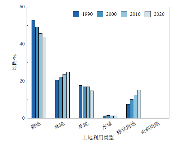
图2 1990-2020年京津冀地区各类型景观面积占比
Figure 2 Percentage of landscape area by types in Beijing-Tianjin-Hebei region from 1990 to 2020

图3 1990-2020年京津冀地区各类型景观空间分布图
Figure 3 Spatial distribution of various types of landscape in Beijing-Tianjin-Hebei region from 1990 to 2020
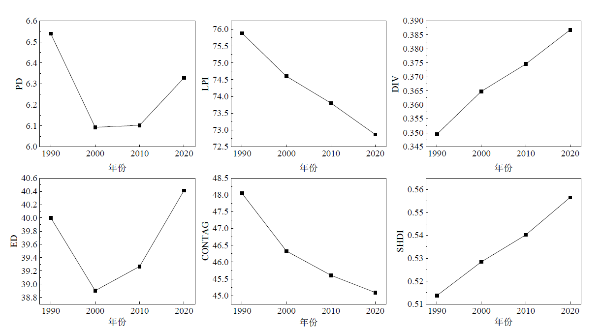
图4 1990-2020年京津冀地区景观格局时空演变特征
Figure 4 Evolutionary characteristics of landscape pattern in Beijing-Tianjin-Hebei region from 1990 to 2020

图5 1990-2020年京津冀地区景观破碎度空间分布图
Figure 5 Spatial distribution of landscape fragmentation in Beijing-Tianjin-Hebei region from 1990 to 2020

图6 京津冀地区景观破碎度变化空间分布图
Figure 6 Spatial distribution of landscape fragmentation changes in Beijing-Tianjin-Hebei region
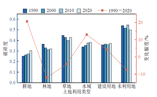
图7 1990-2020年京津冀地区各类型用地破碎度
Figure 7 Fragmentation for various types of land in Beijing-Tianjin-Hebei region from 1990 to 2020
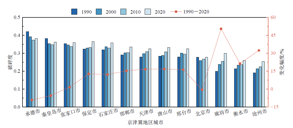
图8 1990-2020年京津冀地区各城市的破碎度
Figure 8 Fragmentation for cities in the Beijing-Tianjin-Hebei region from 1990 to 2020

图9 地理探测器的因子探测结果
Figure 9 Factors detection results of the GeoDetector
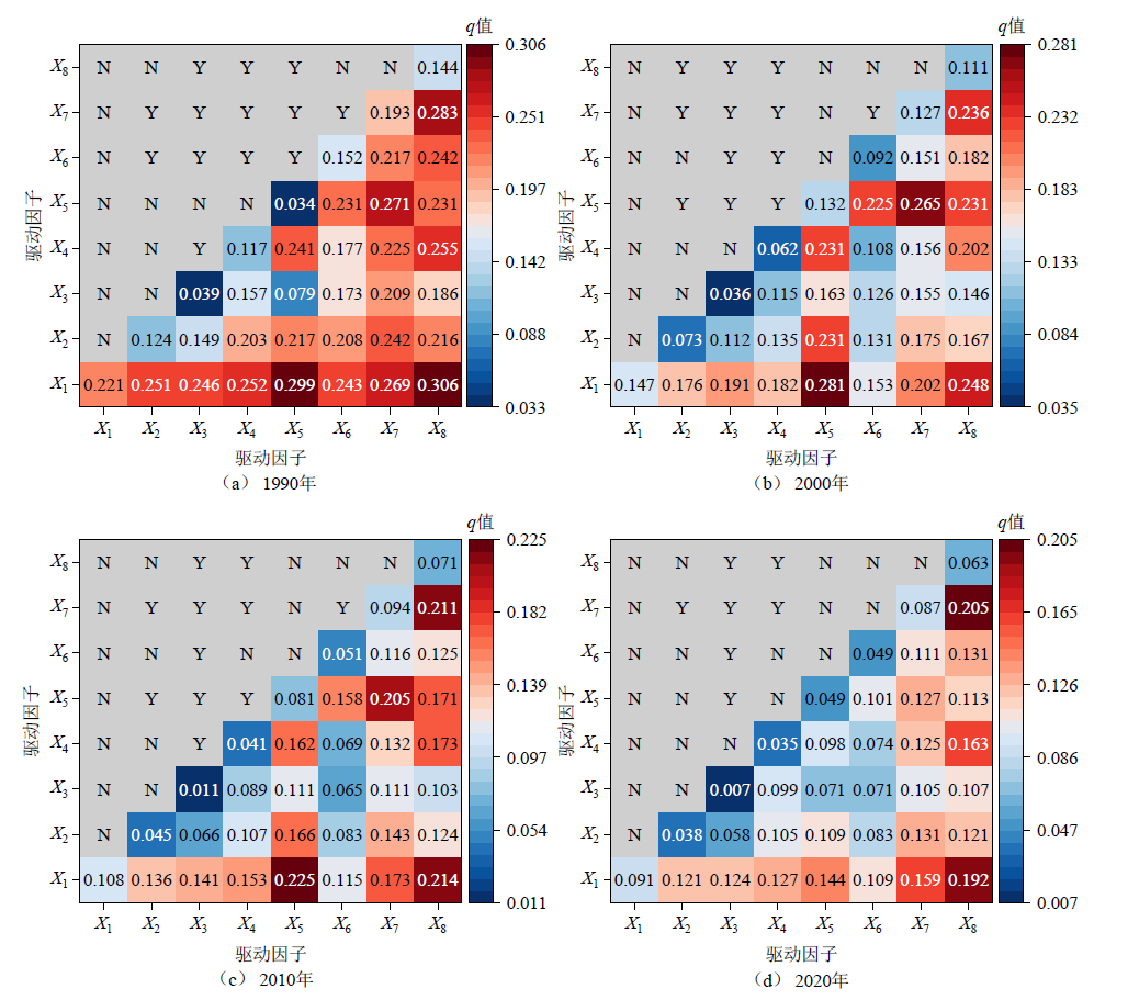
图10 驱动因子的交互探测和生态探测结果
Figure 10 Results of interaction detection and ecological detection of driving factors
| [1] | AI J W, YU K Y, ZENG Z, et al., 2022. Assessing the dynamic landscape ecological risk and its driving forces in an island city based on optimal spatial scales: Haitan Island, China[J]. Ecological Indicators, 137: 108771. |
| [2] | CLAUDIA C, FRANCESCO C, et al., 2017. Landscape fragmentation and urban sprawl in the urban region of Milan[J]. Landscape Research, 43(5): 632-651. |
| [3] | FOELSKE L, VAN RIPER C J, 2020. Assessing spatial preference heterogeneity in a mixed-use landscape[J]. Applied Geography, 125: 102355. |
| [4] | HOSSAIN M S, RAMIREZ J A, HAISCH T, et al., 2020. A coupled human and landscape conceptual model of risk and resilience in Swiss Alpine communities[J]. Science of The Total Environment, 730: 138322. |
| [5] | LEMOINE-RODRÍGUEZ R, INOSTROZA L, ZEPP H, 2020. The global homogenization of urban form. An assessment of 194 cities across time[J]. Landscape and Urban Planning, 204: 103949. |
| [6] | LI S C, BING Z L, JIN G, 2019. Spatially explicit mapping of soil conservation service in monetary units due to land use/cover change for the Three Gorges Reservoir area, China[J]. Remote Sensing, 11(4): 468. |
| [7] | LONG H L, QU Y, 2018. Land use transitions and land management: A mutual feedback perspective[J]. Land Use Policy, 74: 111-120. |
| [8] | SHAHDOOSTI H R, GHASSEMIAN H, 2016. Combining the spectral PCA and spatial PCA fusion methods by an optimal filter[J]. Information Fusion, 27: 150-160. |
| [9] | SNELDER T, LILBURNE L, BOOKER D, et al., 2023. Land-use suitability is not an intrinsic property of a land parcel[J]. Environmental Management, 71: 981-997. |
| [10] | TAO B, YANG Y J, YANG J, et al., 2020. Recent shrinkage and fragmentation of bluegrass landscape in Kentucky[J]. Remote Sensing, 12(11): 1815. |
| [11] | WANG H, LIU X M, ZHAO C Y, et al., 2021. Spatial-temporal pattern analysis of landscape ecological risk assessment based on land use/land cover change in Baishuijiang National nature reserve in Gansu Province, China[J]. Ecological Indicators, 124: 107454. |
| [12] | WEI L, LUO Y, WANG M, et al., 2020. Essential fragmentation metrics for agricultural policies: Linking landscape pattern, ecosystem service and land use management in urbanizing China[J]. Agricultural Systems, 182: 102833. |
| [13] | WU J G, 2004. Effects of changing scale on landscape pattern analysis: Scaling relations[J]. Landscape Ecology, 19(2): 125-138. |
| [14] |
WU J M, HOU Y J, CUI Z, 2024. Coupled InVEST-MGWR modeling to analyze the impacts of changing landscape patterns on habitat quality in the Fen River basin[J]. Scientific Reports, 14: 13084.
DOI PMID |
| [15] | YANG J, HUANG X, 2021. The 30 m annual land cover dataset and its dynamics in China from 1990 to 2019[J]. Earth System Science Data, 13(8): 3907-3925. |
| [16] | ZOU L L, WANG J Y, BAI M D, 2022. Assessing spatial-temporal heterogeneity of China’s landscape fragmentation in 1980-2020[J]. Ecological Indicators, 136: 108654. |
| [17] | 常玉旸, 高阳, 谢臻, 等, 2021. 京津冀地区生境质量与景观格局演变及关联性[J]. 中国环境科学, 41(2): 848-859. |
| CHANG Y Y, GAO Y, XIE Z, et al., 2021. Spatiotemporal evolution and spatial correlation of habitat quality and landscape pattern over Beijing-Tianjin-Hebei region[J]. China Environmental Science, 41(2): 848-859. | |
| [18] |
陈万旭, 李江风, 朱丽君, 2019. 长江中游地区生态系统服务价值空间分异及敏感性分析[J]. 自然资源学报, 34(2): 325-337.
DOI |
| CHEN W X, LI J F, ZHU L J, 2019. Spatial heterogeneity and sensitivity analysis of ecosystem services value in the Middle Yangtze River region[J]. Journal of Natural Resources, 34(2): 325-337. | |
| [19] | 付刚, 肖能文, 乔梦萍, 等, 2017. 北京市近二十年景观破碎化格局的时空变化[J]. 生态学报, 37(8): 2551-2562. |
| FU G, XIAO N W, QIAO M P, et al., 2017. Spatial-temporal changes of landscape fragmentation patterns in Beijing in the last two decades[J]. Acta Ecologica Sinica, 37(8): 2551-2562. | |
| [20] |
高祖桥, 白永平, 周亮, 等, 2020. 宁夏沿黄城市带湿地景观格局演变特征及驱动力[J]. 应用生态学报, 31(10): 3499-3508.
DOI |
| GAO Z Q, BAI Y P, ZHOU L, et al., 2020. Characteristics and driving forces of wetland landscape pattern evolution of the city belt along the Yellow River in Ningxia, China[J]. Chinese Journal of Applied Ecology, 31(10): 3499-3508. | |
| [21] | 郭帅, 裴艳茜, 胡胜, 等, 2020. 黄河流域植被指数对气候变化的响应及其与水沙变化的关系[J]. 水土保持通报, 40(3): 1-7, 13. |
| GUO S, PEI Y Q, HU S, et al., 2020. Response of vegetation index to climate change and their relationship with runoff-sediment change in Yellow River basin[J]. Bulletin of Soil and Water Conservation, 40(3): 1-7, 13. | |
| [22] | 冀正欣, 许月卿, 黄安, 等, 2022. 冀北山区 “三生” 空间识别与演化特征分析——以张家口市为例[J]. 北京大学学报(自然科学版), 58(1): 123-134. |
| JI Z X, XU Y Q, HUANG A, et al., 2022. Spatial pattern and evolution characteristics of the Production-Living-Ecological space in the mountainous area of northern Hebei province: A case study of Zhangjiakou city[J]. Acta Scientiarum Naturalium Universitatis Pekinensis, 58(1): 123-134. | |
| [23] | 焦利民, 肖丰涛, 许刚, 等, 2015. 武汉都市区绿地破碎化格局对城市扩张的时空响应[J]. 资源科学, 37(8): 1650-1660. |
| JIAO L M, XIAO F T, XU G, et al., 2015. Spatial-temporal response of green land fragmentation patterns to urban expansion in Wuhan metropolitan area[J]. Resources Science, 37(8): 1650-1660. | |
| [24] | 李栋科, 丁圣彦, 梁国付, 等, 2014. 基于移动窗口法的豫西山地丘陵地区景观异质性分析[J]. 生态学报, 34(12): 3414-3424. |
| LI D K, DING S Y, LIANG G F, et al., 2014. Landscape heterogeneity of mountainous and hilly area in the western Henan Province based on moving window method[J]. Acta Ecologica Sinica, 34(12): 3414-3424. | |
| [25] |
李文秀, 燕振刚, 2024. 基于地理探测器的甘肃农牧交错带土地利用时空演化及其驱动机制[J]. 干旱区研究, 41(4): 590-602.
DOI |
|
LI W X, YAN Z G, 2024. Analysis of spatiotemporal evolution of land use and its driving mechanism in the agro-pastoral ecotone of Gansu Province using Geodetector[J]. Arid Zone Research, 41(4): 590-602.
DOI |
|
| [26] | 梁加乐, 陈万旭, 李江风, 等, 2022. 黄河流域景观破碎化时空特征及其成因探测[J]. 生态学报, 42(5): 1993-2009. |
| LIANG J L, CHEN W X, LI J F, et al., 2022. Spatiotemporal patterns of landscape fragmentation and causes in the Yellow River Basin[J]. Acta Ecologica Sinica, 42(5): 1993-2009. | |
| [27] | 刘吉平, 马长迪, 刘雁, 等, 2017. 基于地理探测器的沼泽湿地变化驱动因子定量分析——以小三江平原为例[J]. 东北师大学报(自然科学版), 49(2): 127-135. |
| LIU J P, MA C D, LIU Y, et al., 2017. Quantitative study on the driving factors of marsh change based in Geographical Detector: Case study on small Sanjiang plain[J]. Journal of Northeast Normal University (Natural Science Edition), 49(2): 127-135. | |
| [28] |
马寅秋, 李佳慧, 曹巍, 等, 2024. 京津冀地区退耕还林还草碳增汇潜力及贡献预估[J]. 地理学报, 79(3): 732-746.
DOI |
|
MA Y Q, LI J H, CAO W, et al., 2024. Projecting the carbon sink potential and contribution of Grain for Green Program in the Beijing-Tianjin-Hebei region[J]. Acta Geographica Sinica, 79(3): 732-746.
DOI |
|
| [29] | 买迪娜艾尼瓦尔, 阿里木江卡斯木, 2024. 基于移动窗口法的库尔勒市土地利用景观格局特征分析[J]. 西北林学院学报, 39(2): 247-255. |
| MAIDINA A, ALIMUJIANG K, 2024. Characteristics of landscape pattern of land use in Korla City based on moving window method[J]. Journal of Northwest Forestry University, 39(2): 247-255. | |
| [30] | 潘竟虎, 刘晓, 2015. 基于空间主成分和最小累积阻力模型的内陆河景观生态安全评价与格局优化——以张掖市甘州区为例[J]. 应用生态学报, 26(10): 3126-3136. |
| PAN J H, LIU X, 2015. Assessment of landscape ecological security and optimization of landscape pattern based on spatial principal component analysis and resistance model in arid inland area: A case study of Ganzhou District, Zhangye City, Northwest China[J]. Chinese Journal of Applied Ecology, 26(10): 3126-3136. | |
| [31] | 潘梅, 陈天伟, 黄麟, 等, 2020. 京津冀地区生态系统服务时空变化及驱动因素[J]. 生态学报, 40(15): 5151-5167. |
| PAN M, CHEN T W, HUANG L, et al., 2020. Spatial and temporal variations in ecosystem services and its driving factors analysis in Jing-Jin-Ji region[J]. Acta Ecologica Sinica, 40(15): 5151-5167. | |
| [32] | 任浩洋, 刘艳军, 王肖惠, 等, 2024. 快速城镇化地区土地利用景观格局演化及影响因素——以苏州市为例[J]. 东北师大学报(自然科学版), 56(1): 143-153. |
| REN H Y, LIU Y J, WANG X H, et al., 2024. Evolution of land use landscape pattern and influencing factors in rapid urbanization areas: a case study of Suzhou City[J]. Journal of Northeast Normal University (Natural Science Edition), 56(1): 143-153. | |
| [33] |
王劲峰, 徐成东, 2017. 地理探测器: 原理与展望[J]. 地理学报, 72(1): 116-134.
DOI |
|
WANG J F, XU C D, 2017. Geodetector: Principle and prospective[J]. Acta Geographica Sinica, 72(1): 116-134.
DOI |
|
| [34] |
王婧, 刘奔腾, 李裕瑞, 2018. 京津冀人口时空变化特征及其影响因素[J]. 地理研究, 37(9): 1802-1817.
DOI |
| WANG J, LIU B T, LI Y R, 2018. Spatial-temporal characteristics and influencing factors of population distribution and floating changes in Beijing-TianjinHebei region[J]. Geographical Research, 37(9): 1802-1817. | |
| [35] | 王思楠, 吴英杰, 王宏宙, 等, 2024. 基于地理探测器的鄂尔多斯遥感干旱时空变化驱动因素分析[J/OL]. 干旱区研究: 1-12. [2024-12-30]. http://kns.cnki.net/kcms/detail/65.1095.X.20241115.1751.004. |
| WANG S N, WU Y J, WANG H Z, et al., 2024. Spatial and temporal drivers of drought analysis using the geodetector in Ordos[J/OL]. Arid Zone Research, 1-12. [2024-12-30]. http://kns.cnki.net/kcms/detail/65.1095.X.20241115.1751.004. | |
| [36] |
王云, 周忠学, 郭钟哲, 2014. 都市农业景观破碎化过程对生态系统服务价值的影响——以西安市为例[J]. 地理研究, 33(6): 1097-1105.
DOI |
| WANG Y, ZHOU Z X, GUO Z Z, 2014. Impact of the urban agricultural landscape fragmentation on ecosystem services: A case study of Xi’an City[J]. Geographical Research, 33(6): 1097-1105. | |
| [37] | 邬紫荆, 李枝坚, 曾辉, 2021. 惠州市景观格局空间分异特征的梯度分析[J]. 生态学杂志, 40(2): 490-500. |
|
WU Z J, LI Z J, ZENG H, 2021. A gradient analysis of urban landscape pattern in Huizhou[J]. Chinese Journal of Ecology, 40(2): 490-500.
DOI |
|
| [38] | 巫丽芸, 何东进, 游巍斌, 等, 2020. 东山岛海岸带景观破碎化时空梯度分析[J]. 生态学报, 40(3): 1055-1064. |
| WU L Y, HE D J, YOU W B, et al., 2020. A gradient analysis of coastal landscape fragmentation change in Dongshan island, China[J]. Acta Ecologica Sinica, 40(3): 1055-1064. | |
| [39] | 熊畅, 吴卓, 曾梓瑶, 等, 2023. 基于 “空间形态-破碎化-聚集度” 的粤港澳大湾区森林景观格局时空演变[J]. 生态学报, 43(8): 3032-3044. |
| XIONG C, WU Z, ZENG Z Y, et al., 2023. Spatiotemporal evolution of forest landscape pattern in “spatial Morphology-Fragmentation-Aggregation”[J]. Acta Ecologica Sinica, 43(8): 3032-3044. | |
| [40] | 徐芝英, 胡云锋, 刘越, 等, 2012. 空间尺度转换数据精度评价的准则和方法[J]. 地理科学进展, 31(12): 1574-1582. |
|
XU Z Y, HU Y F, LIU Y, et al., 2012. A review on the accuracy analysis of spatial scaling data[J]. Progress in Geography, 31(12): 1574-1582.
DOI |
|
| [41] |
闫宇星, 杨园园, 王永生, 等, 2023. 近40年京津冀地区生境质量变化趋势与归因分析[J]. 遥感技术与应用, 38(2): 251-263.
DOI |
| YAN Y X, YANG Y Y, WANG Y S, et al., 2023. Trends and attribution analysis of habitat quality changes in Beijing-Tianjin-Hebei region over the past 40 years[J]. Remote Sensing Technology and Application, 38(2): 251-263. | |
| [42] |
元冰瑜, 高建华, 池源, 等, 2022. 1990-2020年江苏省海岸带景观生态状况指数跨尺度时空特征[J]. 应用生态学报, 33(2): 489-499.
DOI |
| YUAN B Y, GAO J H, CHI Y, et al., 2022. Cross-scale spatiotemporal characteristics of landscape ecological conditions index in coastal zone of Jiangsu Province, China during 1990-2020[J]. Chinese Journal of Applied Ecology, 33(2): 489-499. | |
| [43] |
张金茜, 巩杰, 柳冬青, 2018. 地理探测器方法下甘肃白龙江流域景观破碎化与驱动因子分析[J]. 地理科学, 38(8): 1370-1378.
DOI |
| ZHANG J Q, GONG J, LIU D Q, 2018. Dynamics and driving factors of landscape fragmentation based on Geo Detector in the Bailongjiang watershed of Gansu province[J]. Scientia Geographica Sinica, 38(8): 1370-1378. | |
| [44] | 张磊, 2009. 基于地形起伏度的地貌形态划分研究——以京津冀地区为例[D]. 河北: 河北师范大学: 10-11. |
| ZHANG L, 2009. A study of the geomorphologic forms classification based on relief: Take Beijing-Tianjin-Hebei region for example[D]. Hebei: Hebei Normal University: 10-11. | |
| [45] | 张耀军, 柴多多, 2017. 京津冀县域人口城镇化时空格局及驱动力研究[J]. 人口研究, 41(5): 26-39. |
| ZHANG Y J, CHAI D D, 2017. Spatial-temporal pattern and driving forces of urbanization at county level in Beijing-Tianjin-Hebei megacity region[J]. Population Research, 41(5): 26-39. | |
| [46] | 赵根庄, 王云, 董硕, 等, 2018. 河北坝上草原植被覆盖度时空变化特征分析[J]. 地理信息世界, 25(6): 31-38, 44. |
| ZHAO G Z, WANG Y, DONG S, et al., 2018. Analysis of spatiotemporal variation characteristics of vegetation coverage in Bashang Grassland of Hebei Province[J]. Journal of Spatio-temporal Information, 25(6): 31-38, 44. | |
| [47] | 赵莉, 危小建, 程朋根, 等, 2022. 大南昌都市圈景观破碎化及驱动因素分析[J]. 测绘科学, 47(9): 181-191, 223. |
| ZHAO L, WEI X J, CHENG P G, et al., 2022. Analysis of landscape fragmentation and driving factors in greater Nanchang metropolitan area[J]. Science of Surveying and Mapping, 47(9): 181-191, 223. | |
| [48] | 朱智洺, 徐婕, 林文雪, 2024. 长三角城市群碳减排与经济高质量发展时空耦合及驱动因素[J]. 长江流域资源与环境, 33(10): 2285-2298. |
| ZHU Z M, XU J, LIN W X, 2024. Spatial-temporal coupling and driving factors of carbon emission reduction and high-quality economic development in Yangtze River Delta urban agglomeration[J]. Resources and Environment in the Yangtze Basin, 33(10): 2285-2298. |
| [1] | 李曼, 吴东丽, 何昊, 余慧婕, 赵琳, 刘聪, 胡正华, 李琪. 1990-2020年黄河流域碳储量时空演变及驱动因素研究[J]. 生态环境学报, 2025, 34(3): 333-344. |
| [2] | 郭昭, 师芸, 刘铁铭, 张雨欣, 闫永智. 2001-2020年秦岭北麓NPP时空格局及驱动因素分析[J]. 生态环境学报, 2025, 34(3): 401-410. |
| [3] | 赵乐鋆, 王诗瑶, 赵子渝, 洪星, 李夫星, 吴佳仪, 华婧妤. 2008-2022年华北平原七省市AOD时空变化特征及主要影响因素分析[J]. 生态环境学报, 2025, 34(2): 256-267. |
| [4] | 赵忠宝, 李婧, 刘小丹, 柏祥, 刘昊野, 徐晓娜, 耿世刚, 鲁少波. 河北省森林生态产品价值评估及其空间分布驱动因素研究[J]. 生态环境学报, 2025, 34(2): 321-332. |
| [5] | 汪洋, 李帆, 严笑, 梅言, 李培, 黄林, 赵俊杰. 山地高密度城市空间形态对冬季气溶胶格局的约束力探测——重庆中心城区案例研究[J]. 生态环境学报, 2025, 34(1): 56-66. |
| [6] | 侯金龙, 马志强, 杨澄, 葛双双, 何迪, 董璠. 京津冀地区植被碳源/汇的时空变化特征及影响因素分析[J]. 生态环境学报, 2024, 33(9): 1329-1338. |
| [7] | 吴东阳, 吴家欢, 李伟志, 黄志杰, 杨春亚, 陈火君. 蚓粪、猪粪配施化肥对土壤质量、辣椒生长及品质的影响[J]. 生态环境学报, 2024, 33(9): 1416-1425. |
| [8] | 张舒涵, 姜海玲, 于海淋, 冯馨慧. 沈阳现代化都市圈景观生态风险时空演变及驱动力分析[J]. 生态环境学报, 2024, 33(9): 1471-1481. |
| [9] | 戴晓爱, 马佳欣, 唐艺菱, 李为乐. 甘肃省植被时空动态变化及其归因分析[J]. 生态环境学报, 2024, 33(8): 1163-1173. |
| [10] | 王雪融, 龚建周, 俞方圆. 粤港澳大湾区4种生态系统调节服务的互馈关系及机制[J]. 生态环境学报, 2024, 33(7): 1130-1141. |
| [11] | 张维琛, 王惺琪, 王博杰. 塔布河流域生态系统服务时空格局及影响因素分析[J]. 生态环境学报, 2024, 33(7): 1142-1152. |
| [12] | 廖洪圣, 卫伟, 石宇. 黄土丘陵区典型流域土壤侵蚀时空演变特征及其驱动机制:以祖厉河为例[J]. 生态环境学报, 2024, 33(6): 908-918. |
| [13] | 王美娜, 范顺祥, 舒翰俊, 张建杰, 褚力其, 法玉琦. 河南省土壤侵蚀时空分异特征及土壤保持经济价值[J]. 生态环境学报, 2024, 33(5): 730-744. |
| [14] | 田叙辰, 魏洪玲, 解胜男, 储启名, 杨婧, 张颖, 肖思秋, 唐中华, 刘英, 李德文. 基于MaxEnt模型的东北地区槭树潜在地理分布[J]. 生态环境学报, 2024, 33(4): 509-519. |
| [15] | 李霞, 陈永昊, 陈喆, 张国壮, 唐梦雅. 中国沿海地区植被NDVI时空变化及驱动力分析[J]. 生态环境学报, 2024, 33(2): 180-191. |
| 阅读次数 | ||||||
|
全文 |
|
|||||
|
摘要 |
|
|||||