生态环境学报 ›› 2024, Vol. 33 ›› Issue (9): 1471-1481.DOI: 10.16258/j.cnki.1674-5906.2024.09.014
张舒涵( ), 姜海玲*(), 于海淋, 冯馨慧
收稿日期:2024-05-10
出版日期:2024-09-18
发布日期:2024-10-18
通讯作者:
*姜海玲。E-mail: hai.ling.1986@163.com作者简介:张舒涵(1999年生),女,硕士研究生,主要研究方向为生态环境遥感。E-mail: jlzhangsh99@163.com
基金资助:
ZHANG Shuhan(), JIANG Hailing*(), YU Hailin, FENG Xinhui
Received:2024-05-10
Online:2024-09-18
Published:2024-10-18
摘要:
沈阳现代化都市圈作为辽宁省规划构建的关键区域协调发展格局,具有重要的战略地位。多重因素的综合影响改变了城市景观结构,降低了景观生态质量,导致生态环境较为脆弱。从景观层面评估区域的景观生态风险、揭示驱动因素是维护区域生态稳定的关键。基于土地利用、DEM、NDVI、气象、社会经济等数据,构建综合景观生态风险评价模型,全面评估2000―2020年间沈阳现代化都市圈的景观生态风险时空演变特征;借助空间自相关模型,揭示景观生态风险空间分异特征;利用参数最优地理探测器,进一步剖析影响景观生态风险变化的主要驱动因子。结果表明,1)2000―2020年间,沈阳现代化都市圈的景观格局显著变化,以林地与耕地为主。建设用地面积增幅最大,面积增加了1.78×10³km2,主要源自于林地和耕地的转入。2)2000―2020年间,区域内生态基本保持稳定。景观生态风险整体呈下降趋势,以较低、中风险区等级为主,生态风险等级降低区域的面积占9.50%,空间上呈现出“西高东低”的分布格局,生态发展有向好势头。3)2000、2010、2020年全局Moran’s I指数值分别为0.534、0.508和0.519,风险高值表明风险分布并非孤立,而是相互关联的,呈显著正相关,具有较强的空间集聚效应。4)单一驱动因素分析,降水量、气温变化、归一化植被指数是驱动景观生态风险变化的主要因素,自然因素对其影响大于社会经济因素。双因子交互探测结果显示,气候因子与地形地貌因子的交互协同效应对景观生态风险的影响最为突出。研究结果可为区域土地资源利用优化和生态风险管控提供科学依据。
中图分类号:
张舒涵, 姜海玲, 于海淋, 冯馨慧. 沈阳现代化都市圈景观生态风险时空演变及驱动力分析[J]. 生态环境学报, 2024, 33(9): 1471-1481.
ZHANG Shuhan, JIANG Hailing, YU Hailin, FENG Xinhui. Spatio-temporal Evolution and Driving Force Analysis of Landscape Ecological Risk in Shenyang Modern Metropolitan[J]. Ecology and Environment, 2024, 33(9): 1471-1481.
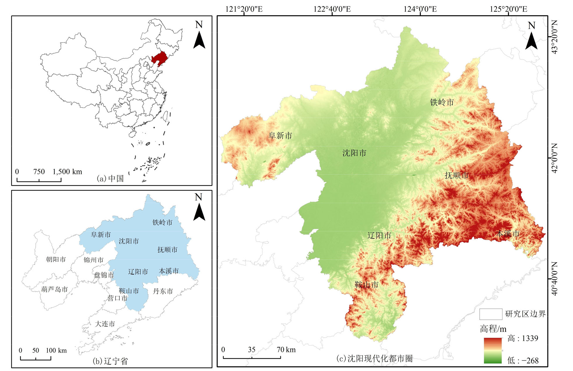
图1 沈阳现代化都市圈地理位置示意图 该图基于审图号为GS(2019) 1822 号的标准地图制作,底图边界无修改
Figure 1 The geographical location of Shenyang modern metropolitan
| 景观类型 | 面积/km2 | 2000‒2020变化量/km2 | |||||
|---|---|---|---|---|---|---|---|
| 2000 | 2010 | 2020 | 2000‒2010 | 2010‒2020 | 2000‒2020 | ||
| 耕地 | 3.53×10⁴ | 3.55×10⁴ | 3.46×10⁴ | 2.20×10² | −8.98×10² | −6.77×10² | |
| 林地 | 2.72×10⁴ | 2.66×10⁴ | 2.65×10⁴ | −5.80×10² | −84.6 | −6.64×10² | |
| 草地 | 1.46×10³ | 7.82×10² | 9.64×10² | −6.78×10² | 1.81×10² | −4.96×10² | |
| 水域 | 6.05×10² | 7.45×10² | 6.8×10² | 1.40×10² | −65.5 | 74.8 | |
| 建设用地 | 4.83×10³ | 5.74×10³ | 6.61×10³ | 9.12×10² | 8.68×10² | 1.78×10³ | |
| 未利用地 | 27.6 | 12.2 | 10.3 | −15.5 | −1.87 | −17.3 | |
表1 2000-2020年沈阳现代化都市圈景观类型面积变化情况
Table 1 Landscape type area change of Shenyang Modern Metropolitan from 2000 to 2020
| 景观类型 | 面积/km2 | 2000‒2020变化量/km2 | |||||
|---|---|---|---|---|---|---|---|
| 2000 | 2010 | 2020 | 2000‒2010 | 2010‒2020 | 2000‒2020 | ||
| 耕地 | 3.53×10⁴ | 3.55×10⁴ | 3.46×10⁴ | 2.20×10² | −8.98×10² | −6.77×10² | |
| 林地 | 2.72×10⁴ | 2.66×10⁴ | 2.65×10⁴ | −5.80×10² | −84.6 | −6.64×10² | |
| 草地 | 1.46×10³ | 7.82×10² | 9.64×10² | −6.78×10² | 1.81×10² | −4.96×10² | |
| 水域 | 6.05×10² | 7.45×10² | 6.8×10² | 1.40×10² | −65.5 | 74.8 | |
| 建设用地 | 4.83×10³ | 5.74×10³ | 6.61×10³ | 9.12×10² | 8.68×10² | 1.78×10³ | |
| 未利用地 | 27.6 | 12.2 | 10.3 | −15.5 | −1.87 | −17.3 | |

图2 2000-2020年沈阳现代化都市圈景观类型分布图
Figure 2 Landscape type distribution map in Shenyang Modern Metropolitan from 2000 to 2020
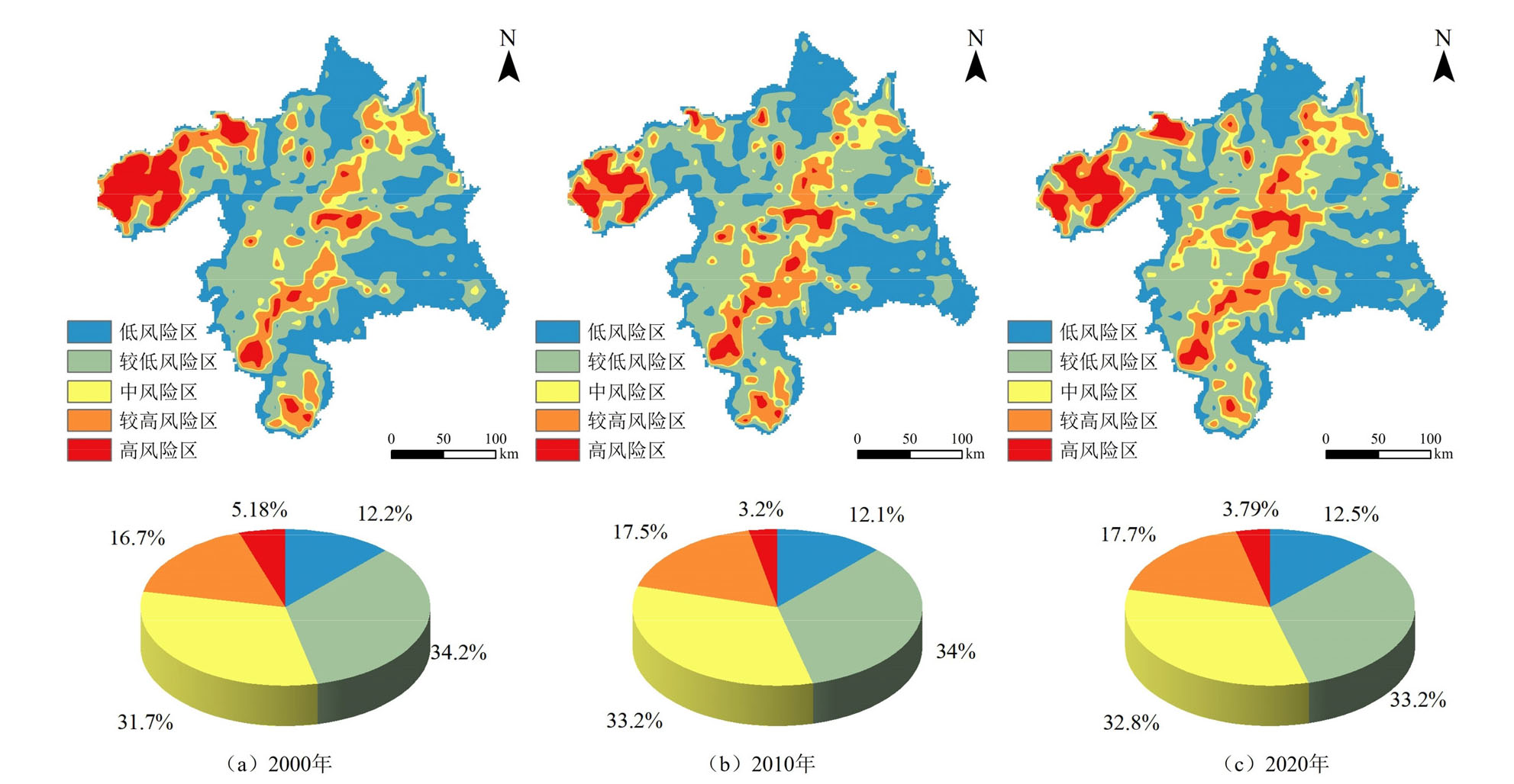
图3 2000-2020年沈阳现代化都市圈景观生态风险时空分布图
Figure 3 Spatial distribution of landscape ecological risks in Shenyang Modern Metropolitan from 2000 to 2020
| 生态风险 等级变化 | 2000‒2010年 | 2010‒2020年 | 2000‒2020年 | |||||
|---|---|---|---|---|---|---|---|---|
| 面积/km2 | 占比/% | 面积/km2 | 占比/% | 面积/km2 | 占比/% | |||
| 风险等级降低 | 8.39×10³ | 12.1 | 3.89×10³ | 5.61 | 6.59×10³ | 9.50 | ||
| 风险等级不变 | 5.41×10⁴ | 78.4 | 5.60×10⁴ | 80.9 | 5.23×10⁴ | 75.4 | ||
| 风险等级升高 | 6.84×10³ | 9.87 | 9.38×10³ | 13.5 | 1.05×10⁴ | 15.1 | ||
表2 景观生态风险等级变化及占比
Table 2 Change and proportion of the area of landscape ecological risk level
| 生态风险 等级变化 | 2000‒2010年 | 2010‒2020年 | 2000‒2020年 | |||||
|---|---|---|---|---|---|---|---|---|
| 面积/km2 | 占比/% | 面积/km2 | 占比/% | 面积/km2 | 占比/% | |||
| 风险等级降低 | 8.39×10³ | 12.1 | 3.89×10³ | 5.61 | 6.59×10³ | 9.50 | ||
| 风险等级不变 | 5.41×10⁴ | 78.4 | 5.60×10⁴ | 80.9 | 5.23×10⁴ | 75.4 | ||
| 风险等级升高 | 6.84×10³ | 9.87 | 9.38×10³ | 13.5 | 1.05×10⁴ | 15.1 | ||
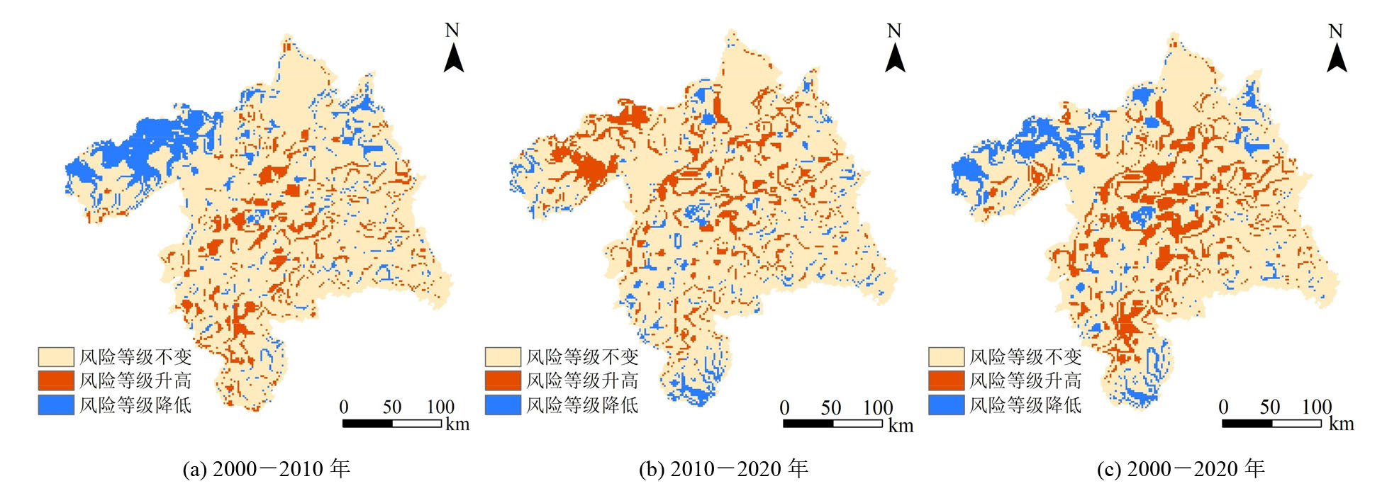
图4 2000-2020年沈阳现代化都市圈景观生态风险等级变化图
Figure 4 Grade change of landscape ecological risk in Shenyang Modern Metropolitan from 2000 to 2020
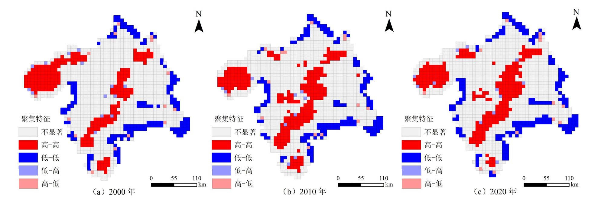
图5 2000-2020年景观生态风险LISA聚集图
Figure 5 Local spatial autocorrelation LISA results of landscape ecological risk level from 2000 to 2020
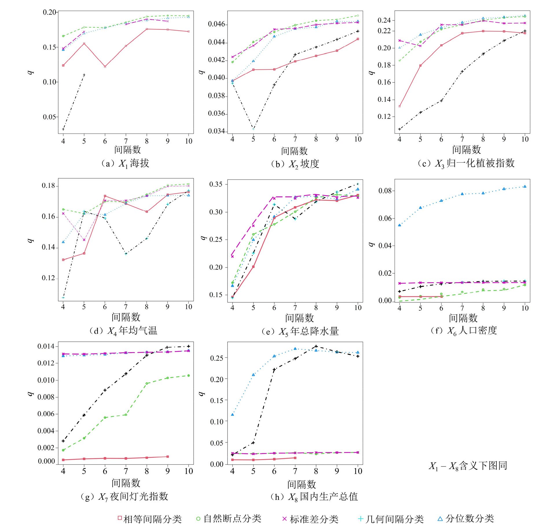
图6 不同分类方法及分区数量q值统计图
Figure 6 Statistical chart of different classification methods and q-values of the number of partitions
| 影响因素 | 影响因子 | q值 | ||
|---|---|---|---|---|
| 2000年 | 2010年 | 2020年 | ||
| 地形地貌 | 高程 | 0.195 | 0.122 | 0.121 |
| 坡度 | 0.047 | 0.044 | 0.062 | |
| 归一化植被指数 | 0.238 | 0.145 | 0.117 | |
| 气候因子 | 年均气温 | 0.182 | 0.242 | 0.233 |
| 年总降水量 | 0.351 | 0.207 | 0.317 | |
| 社会经济 | 人口密度 | 0.083 | 0.120 | 0.098 |
| 夜间灯光指数 | 0.014 | 0.054 | 0.075 | |
| 国内生产总值 | 0.276 | 0.161 | 0.090 | |
表3 单因子探测结果
Table 3 Single factor detection results
| 影响因素 | 影响因子 | q值 | ||
|---|---|---|---|---|
| 2000年 | 2010年 | 2020年 | ||
| 地形地貌 | 高程 | 0.195 | 0.122 | 0.121 |
| 坡度 | 0.047 | 0.044 | 0.062 | |
| 归一化植被指数 | 0.238 | 0.145 | 0.117 | |
| 气候因子 | 年均气温 | 0.182 | 0.242 | 0.233 |
| 年总降水量 | 0.351 | 0.207 | 0.317 | |
| 社会经济 | 人口密度 | 0.083 | 0.120 | 0.098 |
| 夜间灯光指数 | 0.014 | 0.054 | 0.075 | |
| 国内生产总值 | 0.276 | 0.161 | 0.090 | |
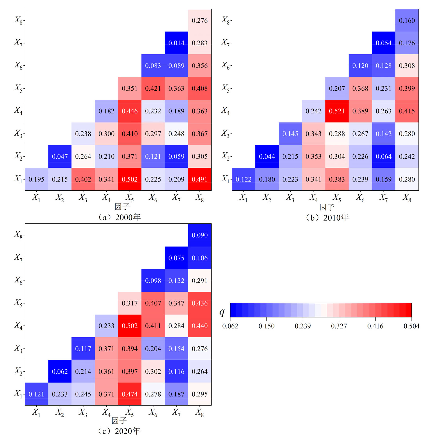
图7 2000—2020年各因子交互作用解释力
Figure 7 Explanatory power of the interaction of each factor from 2000 to 2020
| [1] | BROWN S S, REINERT K H, 1992. Framework for ecological risk assessment[J]. Environmental Toxicology & Chemistry, 11(2): 143-144. |
| [2] | CHEN S Q, CHEN B, FATH B D, 2013. Ecological risk assessment on the system scale: A review of state-of-the-art models and future perspectives[J]. Ecological Modelling, 250: 25-33. |
| [3] | GONG J, CAO E J, XIE Y C, et al., 2021. Integrating ecosystem services and landscape ecological risk into adaptive management: Insights from a western mountain-basin area, China[J]. Journal of Environmental Management, 281: 111817. |
| [4] | GUO X Y, ZHANG Z K, ZHANG X Q, et al., 2023. Landscape vulnerability assessment driven by drought and precipitation anomalies in sub-Saharan Africa[J]. Environmental Research Letters, 18(6): 064035. |
| [5] | HOU M J, GE J, GAO J, et al., 2020. Ecological risk assessment and impact factor analysis of alpine wetland ecosystem based on LUCC and boosted regression tree on the Zoige Plateau, China[J]. Remote Sensing, 12(3): 368. |
| [6] | LIN Y Y, HU X S, ZHENG X X, et al., 2019. Spatial variations in the relationships between road network and landscape ecological risks in the highest forest coverage region of China[J]. Ecological Indicators, 96(Part 1): 392-403. |
| [7] | LIU H, NIU G Y, ZHANG Q X, et al., 2022. Town-level aquatic environmental sensitivity assessment based on an improved ecological footprint model[J]. Water Resources Management, 36: 763-777. |
| [8] | LI Q, GUO F Q, GUAN Y T, 2018. A GIS-based evaluation of environmental sensitivity for an urban expressway in Shenzhen, China[J]. Engineering, 4(2): 230-234. |
| [9] | MALEKMOHAMMADI B, BLOUCHI L R, 2014. Ecological risk assessment of wetland ecosystems using Multi-Criteria Decision Making and Geographic Information System[J]. Ecological Indicators, 41: 133-144. |
| [10] | PENG J, ZONG M L, HU Y N, et al., 2015. Assessing landscape ecological risk in a Mining City: A case study in Liaoyuan City, China[J]. Sustainability, 7(7): 8312-8334. |
| [11] | PETER C, 1998. Ecological Risk Assessment: Risk for What? How Do We Decide?[J]. Eco toxicology and Environmental Safety, 40(1-2): 15-18. |
| [12] | RANI M, REHMAN S, SAJJAD H, et al., 2018. Assessing coastal landscape vulnerability using geospatial techniques along Vizianagaram-Srikakulam coast of Andhra Pradesh, India[J]. Natural Hazards, 94(5): 711-725. |
| [13] | SONG Y Z, WANG J F, GE Y, et al., 2020. An optimal parameters based geographical detector model enhances geographic characteristics of explanatory variables for spatial heterogeneity analysis: cases with different types of spatial data[J]. GIScience & Remote Sensing, 57(5): 593-610. |
| [14] | XU W X, WANG J M, ZHANG M, et al., 2021. Construction of landscape ecological network based on landscape ecological risk assessment in a large-scale opencast coal mine area[J]. Journal of Cleaner Production, 286: 125523. |
| [15] | YAN Y C, JU H R, ZHANG S R, et al., 2021. The Construction of Ecological Security Patterns in Coastal Areas Based on Landscape Ecological Risk Assessment-A Case Study of Jiaodong Peninsula, China[J]. International Journal of Environmental Research and Public Health, 18(22): 12249. |
| [16] | YU T, BAO A M, XU W Q, et al., 2019. Exploring variability in landscape ecological risk and quantifying its driving factors in the amu darya delta[J]. International Journal of Environmental Research and Public Health, 17(1): 79. |
| [17] | ZANG Z, ZOU X Q, ZUO P, et al., 2017. Impact of landscape patterns on ecological vulnerability and ecosystem service values: An empirical analysis of Yancheng Nature Reserve in China[J]. Ecological Indicators, 72: 142-152. |
| [18] | ZHANG C, LÜ W Y, ZHANG P, et al., 2023. Multidimensional spatial autocorrelation analysis and it’s application based on improved Moran’s I[J]. Earth Science Informatics, 16(4): 3355-3368. |
| [19] |
曹祺文, 张曦文, 马洪坤, 等, 2018. 景观生态风险研究进展及基于生态系统服务的评价框架: ESRISK[J]. 地理学报, 73(5): 843-855.
DOI |
|
CAO Q W, ZHANG X W, MA H K, et al., 2018. Review of landscape ecological risk and an assessment framework based on ecological services: ESRISK[J]. Acta Geographica Sinica, 73(5): 843-855.
DOI |
|
| [20] | 陈辉, 刘劲松, 曹宇, 等, 2006. 生态风险评价研究进展[J]. 生态学报, 26(5): 1558-1566. |
| CHEN H, LIU J S, CAO Y, et al., 2006. Progresses of ecological risk assessment[J]. Acta Ecologica Sinica, 26(5): 1558-1566. | |
| [21] | 郭彦君, 郭文炯, 2022. “三生空间” 视角下山西中部盆地城市群景观生态风险分析[J]. 生态学杂志, 41(9): 1813-1824. |
|
GUO Y J, GUO W J, 2022. Landscape ecological risk analysis of urban agglomeration in the central basin of Shanxi from the perspective of “production-living-ecological spaces”[J]. Chinese Journal of Ecology, 41(9): 1813-1824.
DOI |
|
| [22] |
韩美, 孔祥伦, 李云龙, 等, 2021. 黄河三角洲 “三生” 用地转型的生态环境效应及其空间分异机制[J]. 地理科学, 41(6): 1009-1018.
DOI |
| HAN M, KONG X L, LI Y L, et al., 2021. Eco-environmental effects and its spatial heterogeneity of “ecological-production-living” land use transformation in the Yellow River Delta[J]. Scientia Geographica Sinica, 41(6): 1009-1018. | |
| [23] | 刘迪, 陈海, 梁小英, 等, 2018. 黄土丘陵沟壑区生态风险动态变化及其地形梯度分析——以陕西省米脂县为例[J]. 生态学报, 38(23): 8584-8592. |
| LIU D, CHEN H, LIANG X Y, et al., 2018. The dynamic changes to ecological risk in the Loess Hilly-gully Region and its terrain gradient analysis: A case study of Mizhi county, Shaanxi province, China[J]. Acta Ecologica Sinica, 38(23): 8584-8592. | |
| [24] |
雷金睿, 陈宗铸, 陈毅青, 等, 2020. 1990-2018年海南岛湿地景观生态安全格局演变[J]. 生态环境学报, 29(2): 293-302.
DOI |
| LEI J R, CHEN Z Z, CHEN Y Q, et al., 2020. Dynamic analysis of wetland landscape ecological security pattern of Hainan Island in1990-2018[J]. Ecology and Environment Sciences, 29(2): 293-302. | |
| [25] |
金梦婷, 徐丽萍, 徐权, 2021. 基于FLUS-Markov模型的多情景景观生态风险评价与预测——以南疆克州为例[J]. 干旱区研究, 38(6): 1793-1804.
DOI |
| JIN M T, XU L P, XU Q, 2021. FLUS-Markov model-based multi-scenario evaluation and prediction of the landscape ecological risk in Kezhou, South Xinjiang[J]. Arid Zone Research, 38(6): 1793-1804. | |
| [26] | 潘竟虎, 刘晓, 2016. 疏勒河流域景观生态风险评价与生态安全格局优化构建[J]. 生态学杂志, 35(3): 791-799. |
| PAN J H, LIU X, 2016. Landscape ecological risk assessment and ecological security pattern optimization in Shule River Basin[J]. Chinese Journal of Ecology, 35(3): 793-799. | |
| [27] | 王金亮, 陈成龙, 倪九派, 等, 2018. 小流域农业面源污染阻力评价及 “源-汇” 风险空间格局[J]. 农业工程学报, 34(10): 216-224. |
| WANG J L, CHEN C L, NI J P, et al., 2018. Resistance evaluation and “source-sink” risk spatial pattern of agricultural non-point source pollution in small catchment[J]. Transactions of the Chinese Society of Agricultural Engineering (Transactions of the CSAE), 34(10): 216-224. | |
| [28] | 王涛, 张超, 于晓童, 等, 2017. 洱海流域土地利用变化及其对景观生态风险的影响[J]. 生态学杂志, 36(7): 2003-2009. |
| WANG T, ZHANG C, YU X T, et al., 2017. Effect of land use change on landscape ecological security in Erhai Basin[J]. Chinese Journal of Ecology, 36(7): 2003-2009. | |
| [29] | 尉芳, 刘京, 夏利恒, 等, 2022. 基于LUCC的陕西渭北旱塬区景观生态风险评价[J]. 中国环境科学, 42(4): 1963-1974. |
| WEI F, LIU J, XIA L H, et al., 2022. Landscape ecological risk assessment in Weibei dryland region of Shaanxi Province based on LUCC[J]. Chinese Environmental Science, 42(4): 1963-1974. | |
| [30] |
谢小平, 陈芝聪, 王芳, 等, 2017. 基于景观格局的太湖流域生态风险评估[J]. 应用生态学报, 28(10): 3369-3377.
DOI |
| XIE X P, CHEN Z C, WANG F, et al., 2017. Ecological risk assessment of Taihu Lake basin based on landscape pattern[J]. Chinese Journal of Applied Ecology, 28(10): 3369-3377. | |
| [31] |
王劲峰, 徐成东, 2017. 地理探测器: 原理与展望[J]. 地理学报, 72(1): 116-134.
DOI |
|
WANG J F, XU C D, 2017. Geodetector: Principle and prospective[J]. Acta Geographica Sinica, 72(1): 116-134.
DOI |
|
| [32] | 王敏, 胡守庚, 张绪冰, 等, 2022. 干旱区绿洲城镇景观生态风险时空变化分析——以张掖绿洲乡镇为例[J]. 生态学报, 42(14): 5812-5824. |
| WANG M, HU S G, ZHANG X B, et al., 2022. Spatio-temporal evolution of landscape ecological risk in oasis cities and towns of arid area: A case study of Zhangye Oasis Township[J]. Acta Ecologica Sinica, 42(14): 5812-5824. | |
| [33] |
汪亚琴, 姚顺波, 侯孟阳, 等, 2021. 基于地理探测器的中国农业生态效率时空分异及其影响因素[J]. 应用生态学报, 32(11): 4039-4049.
DOI |
| WANG Y Q, YAO S B, HOU M Y, et al., 2021. Spatial-temporal differentiation and its influencing factors of agricultural eco-efficiency in China based on geographic detector[J]. Chinese Journal of Applied Ecology, 32(11): 4039-4049. | |
| [34] | 张云路, 李雄, 田野, 2018. 基于景观生态学 “源-汇” 理论的市域尺度生态功能分区——以内蒙古通辽市为例[J]. 生态学报, 38(1):65-72. |
| ZHANG Y L, LI X, TIAN Y, 2018. Study on ecological function zoning in the Municipal Administrative Area based on the landscape ecology source-sink theory: A case study of Tong Liao, Inner Mongolia[J]. Acta Ecologica Sinica, 38(1): 65-72. | |
| [35] | 郑杰, 王志杰, 喻理飞, 等, 2019. 基于景观格局的草海流域生态风险评价[J]. 环境化学, 38(4): 784-792. |
| ZHENG J, WANG Z J, YU L F, et al., 2019. Ecological risk assessment of Caohai watershed based on landscape pattern[J]. Environmental Chemistry, 38(4): 784-792. |
| [1] | 程鹏, 孙明东, 宋晓伟. 中国灰水足迹时空动态演进及驱动因素研究[J]. 生态环境学报, 2024, 33(5): 745-756. |
| [2] | 王美娜, 范顺祥, 舒翰俊, 张建杰, 褚力其, 法玉琦. 河南省土壤侵蚀时空分异特征及土壤保持经济价值[J]. 生态环境学报, 2024, 33(5): 730-744. |
| [3] | 李荣杰, 李惠梅, 武非非, 赵明德, 王诗涵, 孙雪颖. 青海湖流域生态系统服务空间分异规律及驱动力研究[J]. 生态环境学报, 2024, 33(2): 301-309. |
| [4] | 雷金睿, 陈宗铸, 陈毅青, 陈小花, 李苑菱, 吴庭天. 1990—2018年海南岛湿地景观生态安全格局演变[J]. 生态环境学报, 2020, 29(2): 293-302. |
| 阅读次数 | ||||||
|
全文 |
|
|||||
|
摘要 |
|
|||||