生态环境学报 ›› 2024, Vol. 33 ›› Issue (7): 1142-1152.DOI: 10.16258/j.cnki.1674-5906.2024.07.015
张维琛1,2( ), 王惺琪1, 王博杰1,*()
收稿日期:2024-03-04
出版日期:2024-07-18
发布日期:2024-09-04
通讯作者:
*王博杰。E-mail: wbj8383@163.com作者简介:张维琛(1999年生),女,硕士研究生,研究方向为生态系统服务与人类福祉。E-mail: zweichen0726@163.com
基金资助:
ZHANG Weichen1,2(), WANG Xingqi1, WANG Bojie1,*()
Received:2024-03-04
Online:2024-07-18
Published:2024-09-04
摘要:
中国干旱半干旱地区的生态环境脆弱,水资源匮乏,不合理的人类活动导致生态系统退化,探究内蒙古塔布河流域生态系统服务的时空变化特征、影响因素及其交互关系,对于生态系统的可持续管理更有针对性和现实性。基于遥感和GIS技术,利用模型模拟2000、2010和2020年内蒙古塔布河流域产水、粮食供给、防风固沙、固碳等4项生态系统服务时空格局,并通过地理探测器分析生态系统服务的影响因子及其交互作用。结果表明:在空间上,塔布河流域各项生态系统服务总体呈现南高北低的趋势。2000-2020年间,各项生态系统服务总体呈上升趋势,均在2020年达到峰值。其中,产水量增加了94 mm,提高区域占流域总面积的97.4%;粮食产量逐年增加,2020年达到44 t·km−2,增加区域占总面积的95.9%;防风固沙服务在不断提升,截至2020年,高值区的防风固沙量达到114 t·km−2,增加的区域占总面积的78.3%;固碳呈现出先下降后上升的趋势,在2020年达到最高值,为644 g·m−2·a−1,增加区域占总面积的87%。影响该区域生态系统服务的主要因素有年降水、年均温、归一化植被指数(NDVI)等,交互效应对生态系统服务的影响变得更为显著,特别是年降水与土地利用方式的组合,影响系数的增长率高达61%。受地形、气候、植被等自然因素和土地利用方式、人口密度等社会经济因素的影响,2000-2020年塔布河流域的产水、粮食供给、防风固沙及碳固服务均有大幅提升,全域生态系统服务有70%以上的区域呈增加趋势。该研究有助于进一步了解有关季节性河流各生态系统服务及其影响因素的差异,可为干旱半干旱地区的流域生态系统管理和可持续发展提供参考。
中图分类号:
张维琛, 王惺琪, 王博杰. 塔布河流域生态系统服务时空格局及影响因素分析[J]. 生态环境学报, 2024, 33(7): 1142-1152.
ZHANG Weichen, WANG Xingqi, WANG Bojie. Spatiotemporal Pattern and Influencing Factors of the Ecosystem Services in the Tabu River Basin[J]. Ecology and Environment, 2024, 33(7): 1142-1152.

图1 塔布河流域研究区概况 基于自然资源部标准地图服务网站GS (2019) 1697 号的标准地图制作,底图边界无修改
Figure 1 Overview of the tabuhe basin study area
| 服务类型 | 计算模型及原理 | 所需参数 |
|---|---|---|
| 产水 | InVEST模型产水模块: | Yxj ——x栅格单元上土地利用类型j的产水量; Axj ——j类土地利用类型x栅格单元上的年均实际蒸散量; Px——x栅格单元上年均降雨量 |
| 粮食供给 | 经验公式 (赵文亮等, | Gi ——第i个栅格所分配的粮食产量; Gsum——粮食总产量; N——第i个栅格的归一化植被指数; Nsum——研究区耕地或草地的归一化植被指数之和 |
| 防风固沙 | RWEQ模型 (Fryrear, s=150.71×(WF×EF×SCF×K′×COG)−0.3711 (4) SLpv=SLp−SLv (6) | SLpv——防风固沙量; SLp——潜在风蚀量; SLv——实际风蚀量; Qmax——潜在最大输沙能力; x——最大风蚀出现距离; WF、EF、SCF、K′、COG——气候因子、土壤侵蚀因子、土壤结皮因子、地表粗糙度因子和植被覆盖因子 |
| 固碳 | 改进CASA模型 (朱文泉, | P(x, t)——t时间内在像元x处的净初级生产力; A(x, t)——t时间在像元x处所吸收的光合有效辐射; ε(x, t)——实际光能利用率 |
表1 模型所需参数及计算方法
Table 1 Required parameters of model and calculation method
| 服务类型 | 计算模型及原理 | 所需参数 |
|---|---|---|
| 产水 | InVEST模型产水模块: | Yxj ——x栅格单元上土地利用类型j的产水量; Axj ——j类土地利用类型x栅格单元上的年均实际蒸散量; Px——x栅格单元上年均降雨量 |
| 粮食供给 | 经验公式 (赵文亮等, | Gi ——第i个栅格所分配的粮食产量; Gsum——粮食总产量; N——第i个栅格的归一化植被指数; Nsum——研究区耕地或草地的归一化植被指数之和 |
| 防风固沙 | RWEQ模型 (Fryrear, s=150.71×(WF×EF×SCF×K′×COG)−0.3711 (4) SLpv=SLp−SLv (6) | SLpv——防风固沙量; SLp——潜在风蚀量; SLv——实际风蚀量; Qmax——潜在最大输沙能力; x——最大风蚀出现距离; WF、EF、SCF、K′、COG——气候因子、土壤侵蚀因子、土壤结皮因子、地表粗糙度因子和植被覆盖因子 |
| 固碳 | 改进CASA模型 (朱文泉, | P(x, t)——t时间内在像元x处的净初级生产力; A(x, t)——t时间在像元x处所吸收的光合有效辐射; ε(x, t)——实际光能利用率 |
| 变量名称 | 离散方法 | 类别 |
|---|---|---|
| 海拔高度 | 几何间隔 | 10 |
| 年均温 | 分位数间隔 | 9 |
| 年降水 | 自然间隔 | 10 |
| 归一化植被指数 | 分位数间隔 | 10 |
| 人均生产总值 | 分位数间隔 | 10 |
| 人口密度 | 分位数间隔 | 9 |
| 人类足迹 | 分位数间隔 | 9 |
| 土地利用方式 | 手动 | 6 |
表2 地理探测器因子离散化方法与类别
Table 2 Discretization methods and categories of geographic detector factors
| 变量名称 | 离散方法 | 类别 |
|---|---|---|
| 海拔高度 | 几何间隔 | 10 |
| 年均温 | 分位数间隔 | 9 |
| 年降水 | 自然间隔 | 10 |
| 归一化植被指数 | 分位数间隔 | 10 |
| 人均生产总值 | 分位数间隔 | 10 |
| 人口密度 | 分位数间隔 | 9 |
| 人类足迹 | 分位数间隔 | 9 |
| 土地利用方式 | 手动 | 6 |
| 数据名称 | 空间分辨率 | 数据来源 |
|---|---|---|
| 降水 | 1 km | 国家青藏高原科学数据中心 ( |
| 蒸散发 | 1 km | 国家青藏高原科学数据中心 ( |
| 土地利用数据 | 30 m | 中国科学院资源环境科学与数据中心 ( |
| 海拔高度 | 30 m | 地理空间数据云 ( |
| 归一化植被指数 | 30 m | 中国科学院资源环境科学与数据中心 ( |
| 土壤类型 | 1 km | 国家青藏高原科学数据中心 ( |
| 温度 | 30 m | 国家气象数据中心 ( |
| 太阳辐射 | 30 m | 国家气象数据中心 ( |
| 人口密度 | 1 km | Open Spatial Demographic Data and Research ( |
| 人类足迹指数 | 1 km | 中国农业大学土地科学与技术学院的城市环境监测及建模团队 ( |
表3 研究数据来源与描述
Table 3 Source and description of research
| 数据名称 | 空间分辨率 | 数据来源 |
|---|---|---|
| 降水 | 1 km | 国家青藏高原科学数据中心 ( |
| 蒸散发 | 1 km | 国家青藏高原科学数据中心 ( |
| 土地利用数据 | 30 m | 中国科学院资源环境科学与数据中心 ( |
| 海拔高度 | 30 m | 地理空间数据云 ( |
| 归一化植被指数 | 30 m | 中国科学院资源环境科学与数据中心 ( |
| 土壤类型 | 1 km | 国家青藏高原科学数据中心 ( |
| 温度 | 30 m | 国家气象数据中心 ( |
| 太阳辐射 | 30 m | 国家气象数据中心 ( |
| 人口密度 | 1 km | Open Spatial Demographic Data and Research ( |
| 人类足迹指数 | 1 km | 中国农业大学土地科学与技术学院的城市环境监测及建模团队 ( |
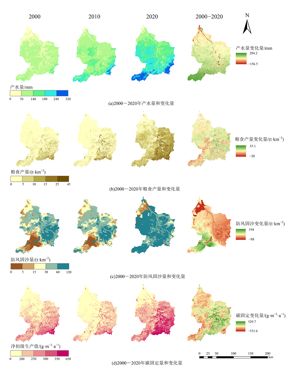
图2 2000-2020年各生态系统服务的空间格局
Figure 2 Spatial pattern of ecosystem services from 2000 to 2020
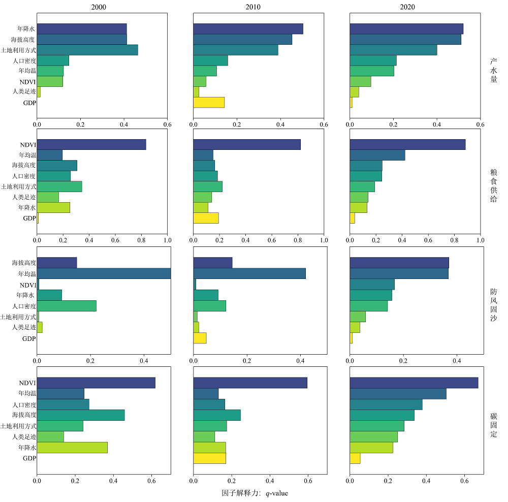
图3 2000-2020年塔布河流域生态系统服务影响因子结果
Figure 3 Results of influencing factors on ecosystem services in the tabu river basin from 2000 to 2020
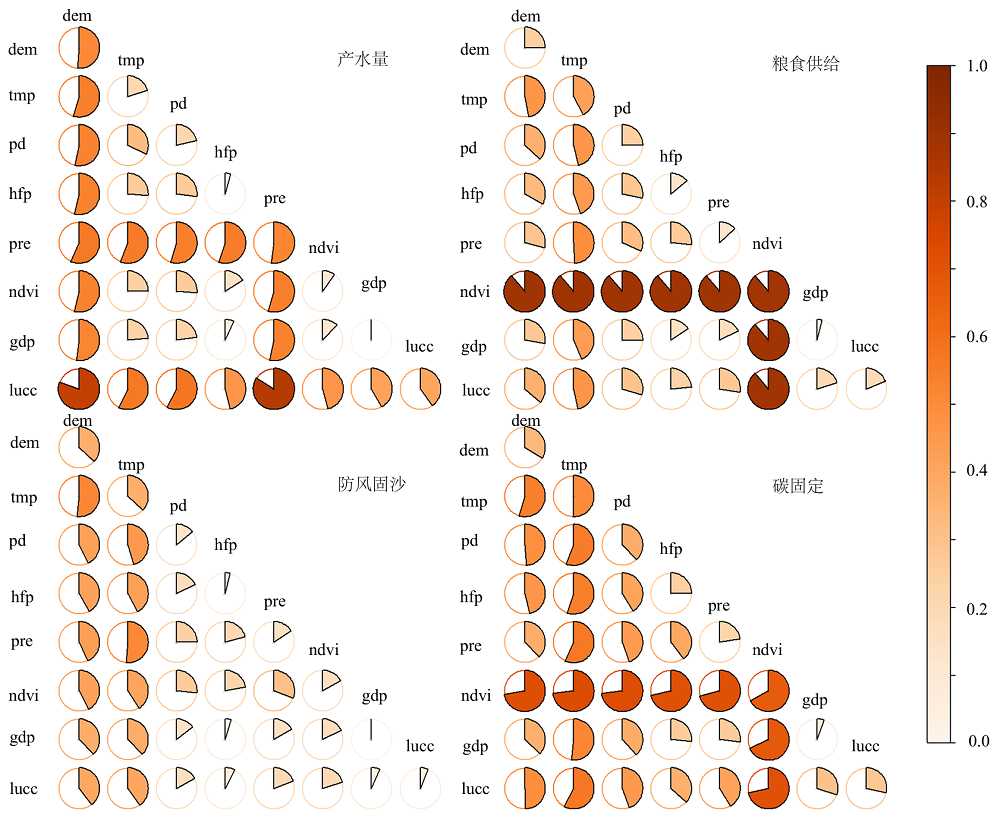
图4 2022年塔布河流域生态系统服务影响因素交互作用结果 dem:地理高程;tmp:年均温;pd:人口密度;hfp:人类足迹指数;pre:年降水;ndvi:归一化植被指数;gdp:人均生产总值;lucc:土地利用方式
Figure 4 Interactive effects of influencing factors on ecosystem services in the tatu river basin in 2022
| 生态系统服务 | 影响因子 | 对应q值 | 交互因子 | 对应q值 | 交互影响 | 增长率/% |
|---|---|---|---|---|---|---|
| 产水 | 土地利用方式 | 0.4002 | 人口密度 | 0.2135 | 0.5771 | 44.2 |
| 土地利用方式 | 0.4002 | 海拔高度 | 0.5110 | 0.8008 | 56.7 | |
| 粮食供给 | 年均温 | 0.4216 | 年降水 | 0.1304 | 0.4901 | 16.3 |
| 年均温 | 0.4216 | 土地利用方式 | 0.1896 | 0.4667 | 10.7 | |
| 防风固沙 | 年均温 | 0.3677 | 年降水 | 0.1568 | 0.5113 | 39.1 |
| 年均温 | 0.3677 | 人口密度 | 0.1407 | 0.4533 | 23.3 | |
| 固碳 | 年均温 | 0.5041 | 年降水 | 0.2246 | 0.5655 | 12.2 |
| 年均温 | 0.5041 | 土地利用方式 | 0.2836 | 0.5747 | 14.0 |
表4 2020年塔布河流域生态系统服务的影响因子交互探测结果对比
Table 4 Results of dominant interaction detection of influencing factors on ecosystem services in the tatu river basin in 2020
| 生态系统服务 | 影响因子 | 对应q值 | 交互因子 | 对应q值 | 交互影响 | 增长率/% |
|---|---|---|---|---|---|---|
| 产水 | 土地利用方式 | 0.4002 | 人口密度 | 0.2135 | 0.5771 | 44.2 |
| 土地利用方式 | 0.4002 | 海拔高度 | 0.5110 | 0.8008 | 56.7 | |
| 粮食供给 | 年均温 | 0.4216 | 年降水 | 0.1304 | 0.4901 | 16.3 |
| 年均温 | 0.4216 | 土地利用方式 | 0.1896 | 0.4667 | 10.7 | |
| 防风固沙 | 年均温 | 0.3677 | 年降水 | 0.1568 | 0.5113 | 39.1 |
| 年均温 | 0.3677 | 人口密度 | 0.1407 | 0.4533 | 23.3 | |
| 固碳 | 年均温 | 0.5041 | 年降水 | 0.2246 | 0.5655 | 12.2 |
| 年均温 | 0.5041 | 土地利用方式 | 0.2836 | 0.5747 | 14.0 |
| [1] | CUI L H, SHEN Z, LIU Y X, et al., 2022. Identification of driving forces for windbreak and sand fixation services in semiarid and arid areas: A case of Inner Mongolia, China[J]. Progress in Physical Geography, 47(1): 32-49. |
| [2] | FANG L L, WANG L C, CHEN W X, et al., 2021. Identifying the impacts of natural and human factors on ecosystem service in the Yangtze and Yellow River Basins[J]. Journal of Cleaner Production, 314(1): 127995. |
| [3] | GU Q, WEI J, LUO S C, et al., 2018. Potential and environmental control of carbon sequestration in major ecosystems across arid and semi-arid regions in China[J]. Science of The Total Environment, 645(2): 796-805. |
| [4] | KANDZIORA M, BURKHARD B, MÜLLER F, 2013. Interactions of ecosystem properties, ecosystem integrity and ecosystem service indicators: A theoretical matrix exercise[J]. Ecological Indicators, 28(3): 54-78. |
| [5] |
LAL R, 2019. Carbon Cycling in Global Drylands[J]. Current Climate Change Reports, 5(3): 221-232.
DOI |
| [6] | LI B J, CHEN D X, WU S H, et al., 2016. Spatio-temporal assessment of urbanization impacts on ecosystem services: Case study of Nanjing City, China[J]. Ecological Indicators, 71(4): 416-427. |
| [7] | LI H N, DANG X H, HAN Y L, et al., 2023. Sand-fixing measures improve soil particle distribution and promote soil nutrient accumulation for desert - Yellow River coastal ecotone, China[J]. Ecological Indicators, 157(5): 111239. |
| [8] | LI Q, ZHANG X F, LIU Q F, et al., 2017. Impact of Land Use Intensity on Ecosystem Services: An example from the agro-pastoral ecotone of central Inner Mongolia[J]. Sustainability, 9(6): 1030. |
| [9] | LI Z H, XIA J, DENG X Z, et al., 2021. Multilevel modelling of impacts of human and natural factors on ecosystem services change in an oasis, Northwest China[J]. Resources Conservation and Recycling, 169(6): 105474. |
| [10] | LIU J J, XU Y, SHAN Y X, et al., 2021. Biotic and abiotic factors determine species diversity-productivity relationships in mountain meadows[J]. Journal of Plant Ecology, 14(6): 1175-1188. |
| [11] | NARAIN P, 2008. Dryland management in arid ecosystem[J]. Journal of the Indian Society of Soil Science, 56(4): 337-347. |
| [12] | SALEH A, FRYREAR D W, 1999. Soil roughness for the revised wind erosion equation (RWEQ)[J]. Journal of Soil and Water Conservation, 54(2): 473-476. |
| [13] | SINGH P K, CHUDASAMA H, 2021. Pathways for climate change adaptations in arid and semi-arid regions[J]. Journal of Cleaner Production, 7(7): 124744. |
| [14] | SONG S R, CHEN X, HU Z Y, et al., 2023. Deciphering the impact of wind erosion on ecosystem services: An integrated framework for assessment and spatiotemporal analysis in arid regions[J]. Ecological Indicators, 154(8): 110693. |
| [15] | WANG H, LIU G H, LI Z S, et al., 2020. Processes and driving forces for changing vegetation ecosystem services: Insights from the Shaanxi Province of China[J]. Ecological Indicators, 112(9): 106105. |
| [16] | WANG L J, GONG J W, MA S, et al., 2022. Ecosystem service supply- demand and socioecological drivers at different spatial scales in Zhejiang Province, China[J]. Ecological Indicators, 140(10): 109058. |
| [17] | XIANG S J, WANG Y, DENG H, et al., 2022. Response and multi-scenario prediction of carbon storage to land use/cover change in the main urban area of Chongqing, China[J]. Ecological Indicators, 142(11): 109205. |
| [18] | XUE C L, ZHANG H Q, WU S M, et al., 2022. Spatial-temporal evolution of ecosystem services and its potential drivers: A geospatial perspective from Bairin Left Banner, China[J]. Ecological Indicators, 137(12): 108760. |
| [19] | YANG Y, TILMAN D, FUREY G, et al., 2019. Soil carbon sequestration accelerated by restoration of grassland biodiversity[J]. Nature Communications, 10(1): 1-7. |
| [20] | YU Y, HUA T, CHEN L D, et al., 2023. Divergent changes in vegetation greenness, productivity, and rainfall use efficiency are characteristic of ecological restoration towards high-quality development in the Yellow River Basin, China[J]. Engineering, 13(13): 109-119. |
| [21] |
YU Y, PI Y Y, YU X, et al., 2019. Climate change, water resources and sustainable development in the arid and semi-arid lands of Central Asia in the past 30 years[J]. Journal of Arid Land, 11(1): 1-14.
DOI |
| [22] |
曹云, 孙应龙, 姜月清, 等, 2022. 黄河流域净生态系统生产力的时空分异特征及其驱动因子分析[J]. 生态环境学报, 31(11): 2101-2110.
DOI |
| CAO Y, SUN Y L, JIANG Y Q, et al., 2022. Analysis on temporal-spatial variations and driving factors of net ecosystem productivity in the Yellow River Basin[J]. Ecology and Environment, 31(11): 2101-2110. | |
| [23] | 陈海霞, 黄宗胜, 赵明伟, 等, 2020. 喀斯特地区4种草本植物及其基质的优先选择[J]. 土壤学报, 57(4): 1017-1031. |
| CHEN H X, HUANG Z S, ZHAO M W, et al., 2020. Four species of herbs in karst areas and their adaptabilities to the karst matrices[J]. Acta Pedologica Sinica, 57(4): 1017-1031. | |
| [24] |
陈云, 李玉强, 王旭洋, 等, 2022. 中国生态脆弱区全球变化风险及应对技术途径和主要措施[J]. 中国沙漠, 42(3): 148-158.
DOI |
|
CHEN Y, LI Y Q, WANG X Y, et al., 2022. Risk and countermeasures of global change in ecologically vulnerable regions of China[J]. Journal of Desert Research, 42(3): 148-158.
DOI |
|
| [25] |
傅伯杰, 于丹丹, 2016. 生态系统服务权衡与集成方法[J]. 资源科学, 38(1): 1-9.
DOI |
|
FU B J, YU D D, 2016. Trade-off analyses and synthetic integrated method of multiple ecosystem services[J]. Resources Science, 38(1): 1-9.
DOI |
|
| [26] |
刘璐璐, 曹巍, 吴丹, 等, 2018. 国家重点生态功能区生态系统服务时空格局及其变化特征[J]. 地理科学, 38(9): 1508-1515.
DOI |
|
LIU L L, CAO W, WU D, et al., 2018. Temporal and spatial variations of ecosystem services in national key ecological function zones[J]. Scientia Geographica Sinica, 38(9): 1508-1515.
DOI |
|
| [27] | 刘利民, 王婷婷, 李秀芬, 等, 2021. 近15年内蒙古防沙带防风固沙功能时空变化特征[J]. 生态学杂志, 40(11): 3436-3447. |
|
LIU L M, WANG T T, LI X F, et al., 2021. Spatiotemporal variations of wind prevention and sand fixation function in the sand-prevention belt in Inner Mongolia in recent 15 years[J]. Chinese Journal of Ecology, 40(11): 3436-3447.
DOI |
|
| [28] |
欧定华, 夏建国, 张莉, 等, 2015. 区域生态安全格局规划研究进展及规划技术流程探讨[J]. 生态环境学报, 24(1): 163-173.
DOI |
| OU D H, XIA J G, ZHANG L, et al., 2015. Research progress on regional ecological security pattern planning and discussion of planning techniqueflow[J]. Ecology and Environmental Sciences, 24(1): 163-173. | |
| [29] |
潘换换, 吴树荣, 姬倩倩, 等, 2021. 山西煤田生态系统服务时空格局及驱动力[J]. 应用生态学报, 32(11): 3923-3932.
DOI |
| PAN H H, WU S R, JI Q Q, et al., 2021. Spatio-temporal pattern and driving forces of ecosystem services in coalfields of Shanxi Province, China[J]. Chinese Journal of Applied Ecology, 32(11): 3923-3932. | |
| [30] | 孙贺阳, 2018. 基于SWAT模型塔布河流域水文模拟与预测[D]. 呼和浩特: 内蒙古大学. |
| SUN H Y, 2018. Hydrologic simulation and prediction basedon the swat model[D]. Hohhot: Inner Mongolia university. | |
| [31] | 田美荣, 高吉喜, 宋国宝, 等, 2017. 基于主导生态功能与生态退化程度的生态修复分区研究[J]. 生态与农村环境学报, 33(1): 7-14. |
| TIAN M R, GAO J X, SONG G B, et al., 2017. Zoning for ecological remediation by dominant ecological function and ecological degradation degree[J]. Journal of Ecology and Rural Environment, 33(1): 7-14. | |
| [32] |
王劲峰, 徐成东, 2017. 地理探测器: 原理与展望[J]. 地理学报, 72(1):116-134.
DOI |
| WANG J F, XU C D, 2017. Geodetector: Principle and prospective[J]. Actc Geographica Sinica, 72(1): 116-134. | |
| [33] |
王琳, 卫伟, 2023. 黄土高原典型县域生态系统服务变化特征及驱动因素[J]. 生态环境学报, 32(6): 1140-1148.
DOI |
| WANG L, WEI W, 2023. Characteristics and driving factors of ecosystem services changes in a typical county of the Loess Plateau[J]. Ecology and Environmental Sciences, 32(6): 1140-1148. | |
| [34] |
王晓峰, 符鑫鑫, 楚冰洋, 等, 2021. 秦岭生态屏障产水服务时空演变特征及驱动要素[J]. 自然资源学报, 36(10): 2507-2521.
DOI |
| WANG X F, FU X X, CHU B Y, et al., 2021. Spatio-temporal variation of water yield and its driving factors in Qinling Mountains barrier region[J]. Journal of Natural Resources, 36(10): 2507-2521. | |
| [35] | 王彦阁, 2020. 内蒙古阴山北麓农牧交错区土地利用动态分析及预测[J]. 浙江林业科技, 40(4): 10-17. |
| WANG Y G, 2020. Analysis and Prediction of Land Use Types in Agro-Pastoral Ecotone in the Northern Yinshan Mountain of Inner Mongolia[J]. Journal of Zhejiang Forestry Science and Technology, 40(4): 10-17. | |
| [36] | 王一, 郝利娜, 许强, 等, 2023. 2001-2019年黄土高原植被覆盖度时空演化特征及地理因子解析[J]. 生态学报, 43(6): 2397-2407. |
| WANG Y, HAO L N, XU Q, et al., 2023. Spatio-temporal variations of vegetation coverage and its geographical factors analysis on the Loess Plateau from 2001 to 2019[J]. Acta Ecologica Sinica, 43(6): 2397-2407. | |
| [37] | 徐勇, 卢云贵, 戴强玉, 等, 2023. 气候变化和土地利用变化对长江中下游地区植被NPP变化相对贡献分析[J]. 中国环境科学, 43(9): 4988-5000. |
| XU Y, LU Y G, DAI Q Y, et al., 2023. Assessment of the relative contribution of climate change and land use change on net primary productivity variation in the middle and lower reaches of the Yangtze River Basin[J]. China Environmental Science, 43(9): 4988-5000. | |
| [38] | 张彪, 王爽, 2020. 锡林郭勒盟风沙源治理区防风固沙功能变化评估[J]. 生态与农村环境学报, 36(3): 291-299. |
| ZHANG B, WANG S, 2020. Dynamic changes of the sand-fixing service in the sandstorm source control region of Xilingol League[J]. Journal of Ecology and Rural Environment, 36(3): 291-299. | |
| [39] | 张浩斌, 王婉, 宋妤婧, 等, 2024. 基于改进遥感生态指数的干旱内流区生态质量评价——以阴山北麓塔布河流域为例[J]. 生态学报, 44(2): 523-543. |
| ZHANG H B, WANG W, SONG Y J, et al., 2024. Ecological index evaluation of arid inflow area based on the modified remote sensing ecological index: A case study of Tabu River Basin at the northern foot of Yin Mountains[J]. Acta Ecologica Sinica, 44(2): 523-543. | |
| [40] | 赵恒谦, 刘轩绮, 刘哿, 等, 2024. 京津风沙源区NPP时空变化及其对治理工程实施的响应[J]. 生态学报, 44(6): 2406-2419. |
| ZHAO H Q, LIU X Q, LIU G, et al., 2024. Spatio-temporal variation of net primary productivity in the Beijing-tianjin sandstorm source area and its response to the implementation of control projects[J]. Acta Ecologica Sinica, 44(6): 2406-2419. | |
| [41] |
张静静, 朱文博, 朱连奇, 等, 2020. 伏牛山地区森林生态系统服务权衡/协同效应多尺度分析[J]. 地理学报, 75(5): 975-988.
DOI |
| ZHANG J J, ZHU W B, ZHU L Q, et al., 2020. Multi-scale analysis of trade-off/synergy effects of forest ecosystem services in the Funiu Mountain Region[J]. Actc Geographica Sinica, 75(5): 975-988. | |
| [42] | 赵文亮, 贺振, 贺俊平, 等, 2012. 基于MODIS-NDVI的河南省冬小麦产量遥感估测[J]. 地理研究, 31(12): 2310-2320. |
| ZHAO W L, HE Z, HE J P, et al., 2012. Remote sensing estimation for winter wheat yield in Henan based on the MODIS-NDVI data[J]. Geographical Research, 31(12): 2310-2320. | |
| [43] | 朱文泉, 2005. 基于GIS和RS的区域陆地植被NPP估算——以中国内蒙古为例[J]. 遥感学报, 5(3): 300-307. |
| ZHU W Q, 2005. Estimating net primary productivity of terrestrial vegetation based on GIS and RS: A Case Study in Inner Mongolia, China[J]. National Remote Sensing Bulletin, 5(3): 300-307. | |
| [44] | 张鑫建, 龙胤慧, 廖梓龙, 等, 2023. 阴山北麓塔布河流域产水量时空变化规律研究[J]. 节水灌溉, 23(10): 98-107. |
| ZHANG X J, LONG Y H, LIAO Z L, et al., 2023. Temporal and spatial variation of water yield in the tabu river basin of the northern Yinshan Mountain[J]. Water Saving Irrigation, 23(10): 98-107. |
| [1] | 徐佳乐, 杨兴川, 赵文吉, 杨志强, 钟一雪, 师乐颜, 马鹏飞. 气候变化背景下内蒙古中西部植被覆盖度演变特征研究[J]. 生态环境学报, 2024, 33(7): 1008-1018. |
| [2] | 王雯, 侯青青, 裴婷婷. 甘肃河东地区坡度对生态系统服务的影响及其阈值效应[J]. 生态环境学报, 2024, 33(7): 1117-1129. |
| [3] | 王雪融, 龚建周, 俞方圆. 粤港澳大湾区4种生态系统调节服务的互馈关系及机制[J]. 生态环境学报, 2024, 33(7): 1130-1141. |
| [4] | 廖洪圣, 卫伟, 石宇. 黄土丘陵区典型流域土壤侵蚀时空演变特征及其驱动机制:以祖厉河为例[J]. 生态环境学报, 2024, 33(6): 908-918. |
| [5] | 向男, 王明旭, 张宏锋, 廖宝淦. 生态保护重要性分区及其长时间序列生境状况时空分异研究——以广东省为例[J]. 生态环境学报, 2024, 33(6): 958-968. |
| [6] | 王鹭莹, 李小马, 甘德欣, 刘鹏翱, 郭胜, 李毅. 长株潭城市群生态系统服务权衡与协同关系的空间异质性及其驱动因素[J]. 生态环境学报, 2024, 33(6): 969-979. |
| [7] | 李程, 程志鹏, 刘育金, 姚义鸣, 李春雷. 全(多)氟烷基化合物生态风险及其管控政策研究[J]. 生态环境学报, 2024, 33(6): 980-996. |
| [8] | 王美娜, 范顺祥, 舒翰俊, 张建杰, 褚力其, 法玉琦. 河南省土壤侵蚀时空分异特征及土壤保持经济价值[J]. 生态环境学报, 2024, 33(5): 730-744. |
| [9] | 田叙辰, 魏洪玲, 解胜男, 储启名, 杨婧, 张颖, 肖思秋, 唐中华, 刘英, 李德文. 基于MaxEnt模型的东北地区槭树潜在地理分布[J]. 生态环境学报, 2024, 33(4): 509-519. |
| [10] | 杨非凡, 何浩. 基于“EVI-ESV”伊犁河谷生态环境评估及生态分区构建[J]. 生态环境学报, 2024, 33(4): 655-664. |
| [11] | 李霞, 陈永昊, 陈喆, 张国壮, 唐梦雅. 中国沿海地区植被NDVI时空变化及驱动力分析[J]. 生态环境学报, 2024, 33(2): 180-191. |
| [12] | 梁燕, 刘家齐, 肖凡, 潘民萍, 韦凯文, 张楚雯, 段敏. 氮沉降形态对西南岩溶区森林土壤有效磷来源的影响[J]. 生态环境学报, 2024, 33(2): 192-201. |
| [13] | 李荣杰, 李惠梅, 武非非, 赵明德, 王诗涵, 孙雪颖. 青海湖流域生态系统服务空间分异规律及驱动力研究[J]. 生态环境学报, 2024, 33(2): 301-309. |
| [14] | 袁茜, 傅开道, 陶雨晨, 张年, 杨丽莎. 澜沧江(云南段)水-气界面氧化亚氮释放通量时空分布特征及其影响因素研究[J]. 生态环境学报, 2024, 33(1): 54-61. |
| [15] | 田成诗, 孙瑞欣. 长江经济带市域生态环境质量空间分异与影响因素分析——基于三生空间的土地利用转型[J]. 生态环境学报, 2023, 32(7): 1173-1184. |
| 阅读次数 | ||||||
|
全文 |
|
|||||
|
摘要 |
|
|||||