生态环境学报 ›› 2022, Vol. 31 ›› Issue (9): 1909-1918.DOI: 10.16258/j.cnki.1674-5906.2022.09.022
陈乐1,2( ), 卫伟1,2,3()
收稿日期:2022-01-18
出版日期:2022-09-18
发布日期:2022-11-07
通讯作者:
*卫伟(1978年生),男,研究员,博士,主要研究方向为景观生态与生态水文。E-mail: weiwei@rcees.ac.cn作者简介:陈乐(1993年生),女,博士研究生,研究方向为景观生态与生态遥感。E-mail: 1113819261@qq.com
基金资助:
CHEN Le1,2(), WEI Wei1,2,3()
Received:2022-01-18
Online:2022-09-18
Published:2022-11-07
摘要:
基于土地利用变化探讨干旱区流域生境质量的演变特征及驱动力,对保护干旱区生物多样性、促进生态系统健康具有重要意义。以西北旱区典型流域--玛纳斯河流域为例,基于1980-2020年8期土地利用数据、气象站点数据和DEM数据,借助InVEST模型生境质量模块,定量研究了干旱区流域生境质量的时空变化规律及其复杂驱动因素。结果表明,(1)未利用地和草地是玛纳斯河流域主要的土地利用类型,分别占研究区面积的41.49%和28.54%。(2)耕地持续扩张并侵占草地与未利用地,积雪冰川大面积消融转为裸岩和草地是研究区土地利用变化的基本特征。(3)1980-2020年期间,玛纳斯河流域生境质量呈先改善后持续恶化的趋势,生境质量均值减小了0.059。(4)生境质量空间分布差异显著,整体表现为低山区>高山区>绿洲区>荒漠区,生境质量等级以较低为主,占研究区面积的40.36%以上。(5)耕地扩张不断侵占草地和未利用地、积雪冰川大面积融化以及中、高覆盖度草地退化是玛纳斯河流域生境质量恶化的主要原因。其中耕地扩张侵占草地导致绿洲生境质量大幅度下降。绿洲扩展侵占荒漠以及荒漠-绿洲交错带低覆盖度草地面积的增加是荒漠区生境质量改善主要原因。低山区生境质量变化取决于气候变化导致的中、低覆盖度草地之间的相互转化。积雪冰川融化以及高、中覆盖度草地退化是高山区生境质量恶化的首要原因。因此,今后干旱区应坚持适度追求和因地制宜原则,积极响应和开展重大生态恢复及保护工程建设,加强对草地、湿地、林地、高山冰川等生态系统的保护。
中图分类号:
陈乐, 卫伟. 西北旱区典型流域土地利用与生境质量的时空演变特征[J]. 生态环境学报, 2022, 31(9): 1909-1918.
CHEN Le, WEI Wei. Spatiotemporal Changes in Land Use and Habitat Quality in A Typical Dryland Watershed of Northwest China[J]. Ecology and Environment, 2022, 31(9): 1909-1918.
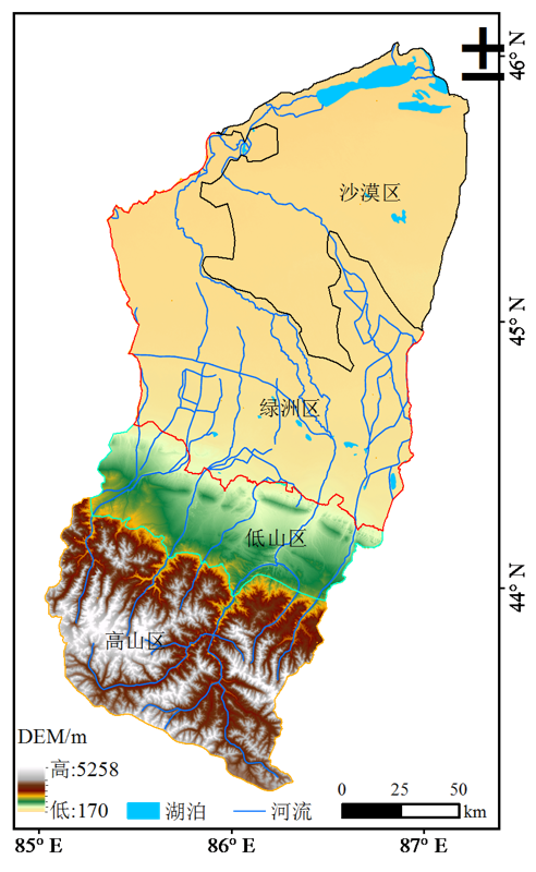
图1 研究区示意图
Figure 1 Sketch map of the study area
| 威胁因子 Threat factor | 最大胁迫距离 Maximum distance of stress/km | 权重 Weight | 空间衰退类型 Spatial decay function |
|---|---|---|---|
| 耕地 Cultivated land | 4 | 0.6 | 线性 |
| 城镇用地 Urban land | 10 | 0.9 | 指数 |
| 农村居民点 Rural land | 5 | 0.6 | 指数 |
| 工矿用地 Industrial land | 7 | 0.7 | 指数 |
| 未利用地 Unused land | 5 | 0.3 | 线性 |
表1 威胁因子及其胁迫强度
Table 1 Threat factors and their stress intensities
| 威胁因子 Threat factor | 最大胁迫距离 Maximum distance of stress/km | 权重 Weight | 空间衰退类型 Spatial decay function |
|---|---|---|---|
| 耕地 Cultivated land | 4 | 0.6 | 线性 |
| 城镇用地 Urban land | 10 | 0.9 | 指数 |
| 农村居民点 Rural land | 5 | 0.6 | 指数 |
| 工矿用地 Industrial land | 7 | 0.7 | 指数 |
| 未利用地 Unused land | 5 | 0.3 | 线性 |
| 土地利用类型 Land use type | 生境适宜度 Habitat suitability | 耕地 Cultivated land | 城镇用地 Urban land | 农村居民点 Rural land | 工矿用地 Industrial land | 未利用地 Unused land |
|---|---|---|---|---|---|---|
| 耕地 Cultivated land | 0.5 | 0 | 0.8 | 0.6 | 0.7 | 0.4 |
| 有林地 Arbor forest land | 1 | 0.8 | 0.95 | 0.85 | 0.7 | 0.5 |
| 灌木林 Shrub land | 1 | 0.5 | 0.8 | 0.65 | 0.7 | 0.6 |
| 疏林地 Sparse forest land | 0.9 | 0.7 | 0.9 | 0.8 | 0.8 | 0.5 |
| 其他林地 Other forest land | 1 | 0.7 | 0.9 | 0.8 | 0.8 | 0.5 |
| 高覆盖度草地 High-coveraged grassland | 0.8 | 0.6 | 0.7 | 0.55 | 0.45 | 0.6 |
| 中覆盖度草地 Medium-coveraged grassland | 0.75 | 0.65 | 0.75 | 0.6 | 0.5 | 0.65 |
| 低覆盖度草地Low-coveraged grassland | 0.7 | 0.7 | 0.8 | 0.65 | 0.55 | 0.7 |
| 湿地 Wetland | 1 | 0.7 | 0.85 | 0.8 | 0.7 | 0.5 |
| 城镇用地 Urban land | 0 | 0 | 0 | 0 | 0 | 0 |
| 农村居民点 Rural land | 0 | 0 | 0 | 0 | 0 | 0 |
| 工矿用地 Industrial land | 0 | 0 | 0 | 0 | 0 | 0 |
| 未利用地 Unused land | 0.2 | 0.4 | 0.5 | 0.45 | 0.4 | 0 |
表2 生境类型对生态威胁因子敏感度
Table 2 Sensitivity of habitat types to ecological threat factors
| 土地利用类型 Land use type | 生境适宜度 Habitat suitability | 耕地 Cultivated land | 城镇用地 Urban land | 农村居民点 Rural land | 工矿用地 Industrial land | 未利用地 Unused land |
|---|---|---|---|---|---|---|
| 耕地 Cultivated land | 0.5 | 0 | 0.8 | 0.6 | 0.7 | 0.4 |
| 有林地 Arbor forest land | 1 | 0.8 | 0.95 | 0.85 | 0.7 | 0.5 |
| 灌木林 Shrub land | 1 | 0.5 | 0.8 | 0.65 | 0.7 | 0.6 |
| 疏林地 Sparse forest land | 0.9 | 0.7 | 0.9 | 0.8 | 0.8 | 0.5 |
| 其他林地 Other forest land | 1 | 0.7 | 0.9 | 0.8 | 0.8 | 0.5 |
| 高覆盖度草地 High-coveraged grassland | 0.8 | 0.6 | 0.7 | 0.55 | 0.45 | 0.6 |
| 中覆盖度草地 Medium-coveraged grassland | 0.75 | 0.65 | 0.75 | 0.6 | 0.5 | 0.65 |
| 低覆盖度草地Low-coveraged grassland | 0.7 | 0.7 | 0.8 | 0.65 | 0.55 | 0.7 |
| 湿地 Wetland | 1 | 0.7 | 0.85 | 0.8 | 0.7 | 0.5 |
| 城镇用地 Urban land | 0 | 0 | 0 | 0 | 0 | 0 |
| 农村居民点 Rural land | 0 | 0 | 0 | 0 | 0 | 0 |
| 工矿用地 Industrial land | 0 | 0 | 0 | 0 | 0 | 0 |
| 未利用地 Unused land | 0.2 | 0.4 | 0.5 | 0.45 | 0.4 | 0 |
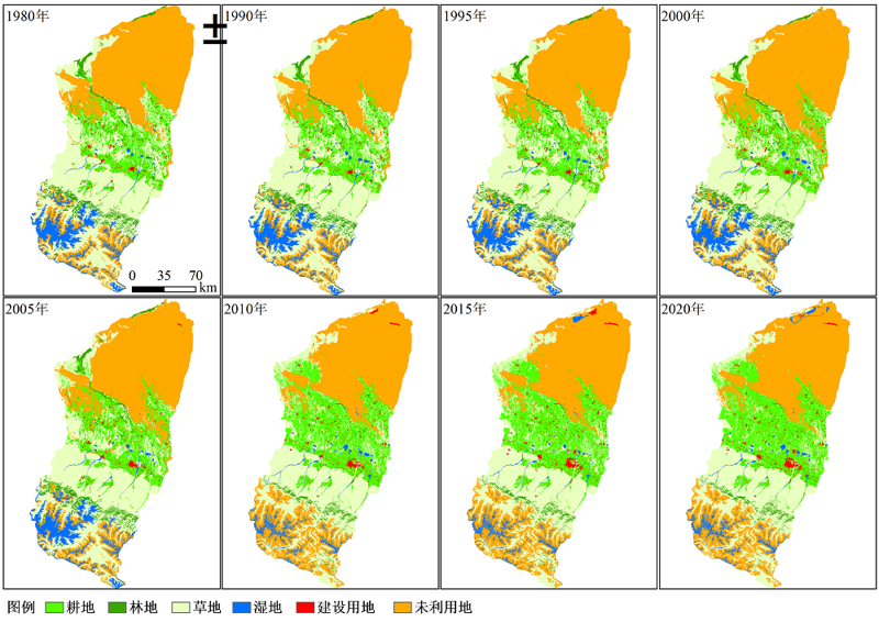
图2 1980-2020年玛纳斯河流域土地利用变化空间分布图
Figure 2 Spatial distribution of land use change in Manas River Basin from 1980 to 2020
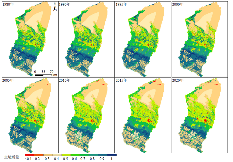
图3 1980-2020年玛纳斯河流域生境质量的空间分布
Figure 3 Spatial distribution of habitat quality in Manas River Basin from 1980 to 2020
| 区域 Region | 年份 The year | |||||||
|---|---|---|---|---|---|---|---|---|
| 1980 | 1990 | 1995 | 2000 | 2005 | 2010 | 2015 | 2020 | |
| 玛纳斯河流域 Manas river basin | 0.5533 | 0.5536 | 0.5539 | 0.5459 | 0.5425 | 0.5024 | 0.5017 | 0.4945 |
| 沙漠区 Desert area | 0.3052 | 0.3051 | 0.3050 | 0.3057 | 0.3056 | 0.3028 | 0.3061 | 0.3088 |
| 绿洲区 Oasis area | 0.5476 | 0.5484 | 0.5490 | 0.5248 | 0.5151 | 0.5067 | 0.5022 | 0.4904 |
| 低山区 Low mountain area | 0.7563 | 0.7561 | 0.7562 | 0.7573 | 0.7570 | 0.7429 | 0.7423 | 0.7407 |
| 高山区 High mountain area | 0.7289 | 0.7289 | 0.7295 | 0.7293 | 0.7294 | 0.5890 | 0.5889 | 0.5886 |
表3 1980-2020年玛纳斯河流域及其各区域生境质量均值
Table 3 Mean value of habitat quality in Manas River Basin and its regions from 1980 to 2020
| 区域 Region | 年份 The year | |||||||
|---|---|---|---|---|---|---|---|---|
| 1980 | 1990 | 1995 | 2000 | 2005 | 2010 | 2015 | 2020 | |
| 玛纳斯河流域 Manas river basin | 0.5533 | 0.5536 | 0.5539 | 0.5459 | 0.5425 | 0.5024 | 0.5017 | 0.4945 |
| 沙漠区 Desert area | 0.3052 | 0.3051 | 0.3050 | 0.3057 | 0.3056 | 0.3028 | 0.3061 | 0.3088 |
| 绿洲区 Oasis area | 0.5476 | 0.5484 | 0.5490 | 0.5248 | 0.5151 | 0.5067 | 0.5022 | 0.4904 |
| 低山区 Low mountain area | 0.7563 | 0.7561 | 0.7562 | 0.7573 | 0.7570 | 0.7429 | 0.7423 | 0.7407 |
| 高山区 High mountain area | 0.7289 | 0.7289 | 0.7295 | 0.7293 | 0.7294 | 0.5890 | 0.5889 | 0.5886 |
| 等级 Grade | 年份 The year | |||||||
|---|---|---|---|---|---|---|---|---|
| 1980 | 1990 | 1995 | 2000 | 2005 | 2010 | 2015 | 2020 | |
| 低 Low | 0.81 | 0.82 | 0.81 | 0.97 | 1.04 | 1.32 | 1.51 | 1.58 |
| 较低 Lower | 40.39 | 40.38 | 40.36 | 41.65 | 41.58 | 42.39 | 42.15 | 42.03 |
| 中等 Medium | 14.44 | 14.36 | 14.36 | 15.04 | 16.28 | 23.74 | 24.02 | 25.2 |
| 较高 Higher | 22.80 | 22.83 | 22.78 | 20.71 | 19.67 | 19.87 | 19.55 | 18.44 |
| 高 High | 21.55 | 21.60 | 21.69 | 21.64 | 21.43 | 12.67 | 12.77 | 12.75 |
表4 1980-2020玛纳斯河流域生境质量各等级面积比例
Table 4 Area proportion of different grades of habitat quality in Manas River Basin from 1980 to 2020 %
| 等级 Grade | 年份 The year | |||||||
|---|---|---|---|---|---|---|---|---|
| 1980 | 1990 | 1995 | 2000 | 2005 | 2010 | 2015 | 2020 | |
| 低 Low | 0.81 | 0.82 | 0.81 | 0.97 | 1.04 | 1.32 | 1.51 | 1.58 |
| 较低 Lower | 40.39 | 40.38 | 40.36 | 41.65 | 41.58 | 42.39 | 42.15 | 42.03 |
| 中等 Medium | 14.44 | 14.36 | 14.36 | 15.04 | 16.28 | 23.74 | 24.02 | 25.2 |
| 较高 Higher | 22.80 | 22.83 | 22.78 | 20.71 | 19.67 | 19.87 | 19.55 | 18.44 |
| 高 High | 21.55 | 21.60 | 21.69 | 21.64 | 21.43 | 12.67 | 12.77 | 12.75 |
| 区域 Region | 年份 Year | 土地利用类型 Land use type | 改善贡献率 Improvement contribution rate/% | 土地利用类型 Land use type | 恶化贡献率 Deterioration Contribution rate/% |
|---|---|---|---|---|---|
| 玛纳斯河流域 Manas river basin | 1980-1995 | 未利用地: 高覆盖度草地 | 22.45 | 中覆盖度草地: 低覆盖度草地 | 29.43 |
| 有林地: 湿地 | 16.47 | 疏林地: 未利用地 | 15.68 | ||
| 未利用地: 疏林地 | 14.32 | 高覆盖度草地: 未利用地 | 11.23 | ||
| 耕地: 中覆盖度草地 | 10.25 | 耕地: 农村居民点 | 9.42 | ||
| 1995-2005 | 未利用地: 耕地 | 19.40 | 低覆盖度草地: 未利用地 | 32.59 | |
| 有林地: 低覆盖度草地 | 9.72 | 低覆盖度草地: 耕地 | 15.62 | ||
| 耕地: 中覆盖度草地 | 8.41 | 中覆盖度草地: 耕地 | 10.04 | ||
| 农村居民点: 耕地 | 8.34 | 高覆盖度草地: 耕地 | 6.77 | ||
| 2005-2010 | 未利用地: 低覆盖度草地 | 22.56 | 湿地: 未利用地 | 32.00 | |
| 未利用地: 耕地 | 21.97 | 高覆盖度草地: 未利用地 | 15.12 | ||
| 未利用地: 高覆盖度草地 | 12.51 | 低覆盖度草地: 耕地 | 10.12 | ||
| 未利用地: 湿地 | 12.49 | 中覆盖度草地: 未利用地 | 5.98 | ||
| 绿洲区 Oasis area | 1980-1995 | 耕地: 湿地 | 23.48 | 疏林地: 未利用地 | 22.80 |
| 未利用地: 疏林地 | 20.40 | 耕地: 农村居民点 | 17.27 | ||
| 耕地: 中覆盖度草地 | 14.57 | 低覆盖度草地: 未利用地 | 14.37 | ||
| 农村居民点: 有林地 | 11.53 | 未利用地: 农村居民点 | 10.15 | ||
| 1995-2020 | 未利用地: 耕地 | 37.93 | 低覆盖度草地: 耕地 | 31.46 | |
| 未利用地: 低覆盖度草地 | 28.17 | 中覆盖度草地: 耕地 | 12.35 | ||
| 农村居民点: 耕地 | 9.89 | 高覆盖度草地: 耕地 | 10.26 | ||
| 荒漠区 Desert area | 1980-2020 | 未利用地: 耕地 | 40.43 | 低覆盖度草地: 未利用地 | 28.36 |
| 未利用地: 低覆盖度草地 | 28.33 | 中覆盖度草地: 未利用地 | 17.20 | ||
| 未利用地: 湿地 | 17.01 | 疏林地: 耕地 | 14.15 | ||
| 低山区 Low mountain area | 1980-2020 | 中覆盖度草地: 高覆盖度草地 | 32.61 | 中覆盖度草地: 低覆盖度草地 | 37.90 |
| 低覆盖度草地: 中覆盖度草地 | 30.38 | 高覆盖度草地: 中覆盖度草地 | 21.75 | ||
| 农村居民点: 耕地 | 10.63 | 中覆盖度草地: 耕地 | 8.72 | ||
| 高山区 High mountain area | 1980-2020 | 未利用地: 低覆盖度草地 | 47.28 | 湿地: 未利用地 | 54.04 |
| 未利用地: 湿地 | 25.54 | 高覆盖度草地: 未利用地 | 24.59 | ||
| 未利用地: 中覆盖度草地 | 9.09 | 中覆盖度草地: 未利用地 | 9.30 |
表5 主要土地利用类型转化对区域生境质量变化的贡献率
Table 5 Contribution rates of major land use types conversions to regional habitat quality
| 区域 Region | 年份 Year | 土地利用类型 Land use type | 改善贡献率 Improvement contribution rate/% | 土地利用类型 Land use type | 恶化贡献率 Deterioration Contribution rate/% |
|---|---|---|---|---|---|
| 玛纳斯河流域 Manas river basin | 1980-1995 | 未利用地: 高覆盖度草地 | 22.45 | 中覆盖度草地: 低覆盖度草地 | 29.43 |
| 有林地: 湿地 | 16.47 | 疏林地: 未利用地 | 15.68 | ||
| 未利用地: 疏林地 | 14.32 | 高覆盖度草地: 未利用地 | 11.23 | ||
| 耕地: 中覆盖度草地 | 10.25 | 耕地: 农村居民点 | 9.42 | ||
| 1995-2005 | 未利用地: 耕地 | 19.40 | 低覆盖度草地: 未利用地 | 32.59 | |
| 有林地: 低覆盖度草地 | 9.72 | 低覆盖度草地: 耕地 | 15.62 | ||
| 耕地: 中覆盖度草地 | 8.41 | 中覆盖度草地: 耕地 | 10.04 | ||
| 农村居民点: 耕地 | 8.34 | 高覆盖度草地: 耕地 | 6.77 | ||
| 2005-2010 | 未利用地: 低覆盖度草地 | 22.56 | 湿地: 未利用地 | 32.00 | |
| 未利用地: 耕地 | 21.97 | 高覆盖度草地: 未利用地 | 15.12 | ||
| 未利用地: 高覆盖度草地 | 12.51 | 低覆盖度草地: 耕地 | 10.12 | ||
| 未利用地: 湿地 | 12.49 | 中覆盖度草地: 未利用地 | 5.98 | ||
| 绿洲区 Oasis area | 1980-1995 | 耕地: 湿地 | 23.48 | 疏林地: 未利用地 | 22.80 |
| 未利用地: 疏林地 | 20.40 | 耕地: 农村居民点 | 17.27 | ||
| 耕地: 中覆盖度草地 | 14.57 | 低覆盖度草地: 未利用地 | 14.37 | ||
| 农村居民点: 有林地 | 11.53 | 未利用地: 农村居民点 | 10.15 | ||
| 1995-2020 | 未利用地: 耕地 | 37.93 | 低覆盖度草地: 耕地 | 31.46 | |
| 未利用地: 低覆盖度草地 | 28.17 | 中覆盖度草地: 耕地 | 12.35 | ||
| 农村居民点: 耕地 | 9.89 | 高覆盖度草地: 耕地 | 10.26 | ||
| 荒漠区 Desert area | 1980-2020 | 未利用地: 耕地 | 40.43 | 低覆盖度草地: 未利用地 | 28.36 |
| 未利用地: 低覆盖度草地 | 28.33 | 中覆盖度草地: 未利用地 | 17.20 | ||
| 未利用地: 湿地 | 17.01 | 疏林地: 耕地 | 14.15 | ||
| 低山区 Low mountain area | 1980-2020 | 中覆盖度草地: 高覆盖度草地 | 32.61 | 中覆盖度草地: 低覆盖度草地 | 37.90 |
| 低覆盖度草地: 中覆盖度草地 | 30.38 | 高覆盖度草地: 中覆盖度草地 | 21.75 | ||
| 农村居民点: 耕地 | 10.63 | 中覆盖度草地: 耕地 | 8.72 | ||
| 高山区 High mountain area | 1980-2020 | 未利用地: 低覆盖度草地 | 47.28 | 湿地: 未利用地 | 54.04 |
| 未利用地: 湿地 | 25.54 | 高覆盖度草地: 未利用地 | 24.59 | ||
| 未利用地: 中覆盖度草地 | 9.09 | 中覆盖度草地: 未利用地 | 9.30 |
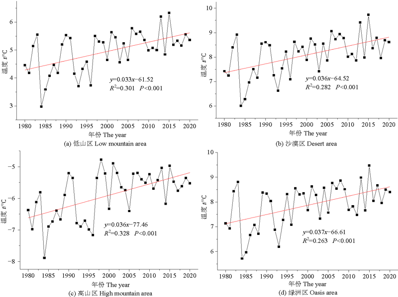
图4 1980-2020年玛纳斯河流域年平均温度趋势变化
Figure 4 Slope change of annual average temperature in Manas River Basin from 1980 to 2020
| [1] |
BAI Y, XU H L, LING H B, 2014. Eco-service value evaluation based on eco-economic functional regionalization in a typical basin of northwest arid area, China[J]. Environmental Earth Sciences, 71(8): 3715-3726.
DOI URL |
| [2] |
BHAGABATI N K, RICKETTS T, SULISTYAWAN T B S, et al., 2014. Ecosystem services reinforce Sumatran tiger conservation in land use plans[J]. Biological Conservation, 169: 147-156.
DOI URL |
| [3] |
CHRISTIANSON K R, JOHNSON B M, HOOTEN M B, 2020. Compound effects of water clarity, inflow, wind and climate warming on mountain lake thermal regimes[J]. Aquatic Sciences, 82(1): 6. 1-6.17.
DOI URL |
| [4] |
FU B, XU P, WANG Y K, et al., 2018. Assessment of the ecosystem services provided by ponds in hilly areas[J]. Science of the Total Environment, 642: 979-987.
DOI URL |
| [5] |
HOTALING S, HOOD E, HAMILTON T L, 2017. Microbial ecology of mountain glacier ecosystems: biodiversity, ecological connections and implications of a warming climate[J]. Environmental microbiology, 19(8): 2935-2948.
DOI PMID |
| [6] |
HUANG J P, YU H P, GUAN X D, et al., 2015. Accelerated dryland expansion under climate change[J]. Nature Climate Change, 6(2): 166-171.
DOI URL |
| [7] | KIM T, SONG C, LEE W, et al., 2015. Habitat quality valuation using InVEST model in Jeju Island[J]. Journal of the Korea Society of Environmental Restoration Technology, 18(5): 1-11. |
| [8] |
LI F X, WANG L Y, CHEN Z J, et al., 2020. Extending the SLEUTH model to integrate habitat quality into urban growth simulation[J]. Journal of Environmental Management, 217(1): 486-498.
DOI URL |
| [9] |
LI X Y, MA Y J, XU H Y, et al., 2010. Impact of land use and land cover change on environmental degradation in Lake Qinghai Watershed, northeast Qinghai-Tibet Plateau[J]. Land Degradation & Development, 20(1): 69-83.
DOI URL |
| [10] |
LI X Y, WANG N L, DING Y J, et al., 2022. Globally elevated chemical weathering rates beneath glaciers[J]. Nature Communications, 13(1): 1-13.
DOI URL |
| [11] |
LING H B, YAN J J, XU H L, et al., 2019. Estimates of shifts in ecosystem service values due to changes in key factors in the Manas River basin, northwest China[J]. Science of the Total Environment, 659: 177-187.
DOI URL |
| [12] | MOHAN M, KANDYA A, 2015. Impact of urbanization and land-use/land-cover change on diurnal temperature range: A case study of tropical urban airshed of India using remote sensing data[J]. Science of the Total Environment, 506-507: 453-465. |
| [13] |
MOSER K A, BARON J S, BRAHNEY J, et al., 2019. Mountain lakes: Eyes on global environmental change[J]. Global and Planetary Change, 178: 77-95.
DOI |
| [14] |
NEWBOLD T, HUDSON L N, HILL S L, et al., 2015. Global effects of land use on local terrestrial biodiversity[J]. Nature, 520: 45-50.
DOI URL |
| [15] |
NIITTYNEN P, HEIKKINEN R K, LUOTO M, 2018. Snow cover is a neglected driver of Arctic biodiversity loss[J]. Nature Climate Change, 8(11): 997-1001.
DOI |
| [16] |
RANGECROFT S, SUGGITT A J, ANDERSON K, et al., 2016. Future climate warming and changes to mountain permafrost in the Bolivian Andes[J]. Climatic Change, 137(1): 231-243.
DOI PMID |
| [17] |
SANDHOLT I, RASMUSSEN K, ANDERSEN J, 2002. A simple interpretation of the surface temperature/vegetation index space for assessment of surface moisture status[J]. Remote Sensing of Environment, 79(2): 213-224.
DOI URL |
| [18] |
SEXSTONE G A, CLOW A W, FASSNAVHT S R, et al., 2018. Snow sublimation in mountain environments and its sensitivity to forest disturbance and climate warming[J]. Water Resources Research, 54(2): 1191-1211.
DOI URL |
| [19] | SHERROUS B C, SEMMENS D J, 2012. Social Values for Ecosystem Services, Version 2. 0 (SolVES 2. 0): Documentation and User Manual[M]. USA: U. S. Geological Survey: 1-71. |
| [20] |
SU B, XIAO C D, CHEN D L, et al., 2022. Glacier change in China over past decades: Spatiotemporal patterns and influencing factors[J]. Earth-Science Reviews, DOI: 10.1016/j.earscirev.2022.103926.
DOI |
| [21] | TALLIS H, RICKETTS T, GUERRY A, et al., 2011. InVEST 2. 2. 4 Users Guide[M]. Stanford: The Natural Capital Project: 1-342. |
| [22] |
XIANG Y Y, MENG J J, 2016. Research into ecological suitability zoning and expansion patterns in agricultural oases based on the landscape process: a case study in the middle reaches of the Heihe River[J]. Environmental Earth Sciences, 75(20): 1-13.
DOI URL |
| [23] |
XU X B, YANG G S, TAN Y, 2019. Identifying ecological red lines in China’s Yangtze River Economic Belt: A regional approach[J]. Ecological Indicators, 96: 635-646.
DOI URL |
| [24] |
YANG G, LI F D, CHEN D, et al., 2019. Assessment of changes in oasis scale and water management in the arid Manas River Basin, north western China[J]. Science of the Total Environment, 691: 506-515.
DOI URL |
| [25] |
ZENG Y, LIU T, ZHOU X B, et al., 2016. Effects of climate change on plant composition and diversity in the Gurbantünggüt Desert of northwestern China[J]. Ecological Research, 31(3): 427-439.
DOI URL |
| [26] |
ZHANG Q Q, XU H L, LI Y, et al., 2012. Oasis evolution and water resource utilization of a typical area in the inland river basin of an arid area: A case study of the Manas River valley[J]. Environmental Earth Sciences, 66(2): 683-692.
DOI URL |
| [27] |
ZHOU D Y, WANG X J, SHI M J, 2017. Human driving forces of oasis expansion in northwestern China during the last decade: A case study of the Heihe River Basin[J]. Land Degradation & Development, 28(2): 412-420.
DOI URL |
| [28] | 陈乐, 刘彤, 李中赫, 等, 2019. 干旱区玛纳斯河流域土地利用/覆被变化对绿洲效应的影响[J]. 石河子大学学报 (自然科学版), 37(4): 480-489. |
| CHEN L, LIU T, LI Z H, et al., 2019. The influence of land use and cover changes on oasis effect in Manasi River Basin in arid area[J]. Journal of Shihezi University (Natural Science), 37(4): 480-489. | |
| [29] | 陈淼, 苏晓磊, 黄慧敏, 等, 2019. 三峡库区河流生境质量评价[J]. 生态学报, 39(1): 196-205. |
| CHEN M, SU X L, HUANG H M, et al., 2019. Assessment of river habitat quality in the Three Gorges Reservoir Region[J]. Acta Ecologica Sinica, 39(1): 192-20. | |
| [30] | 巩杰, 马学成, 张玲玲, 等, 2018. 基于 InVEST 模型的甘肃白龙江流域生境质量时空分异[J]. 水土保持研究, 25(3): 191-196. |
| GONG J, MA X C, ZHANG L L, et al., 2018. Spatiotemporal Variation of habitat quality in Bailongjiang watershed in Gansu based on InVEST model[J]. Research of soil and water conservation, 25(3): 191-196. | |
| [31] | 韩艳莉, 陈克龙, 于德永, 2019. 土地利用变化对青海湖流域生境质量的影响[J]. 生态环境学报, 28(10): 2035-2044. |
| HAN Y L, CHEN K L, YU D Y, 2019. Evaluation on the impact of land use change on habitat quality in Qinghai Lake basin[J]. Ecology and Environmental Sciences, 28(10): 2035-2044. | |
| [32] | 康紫薇, 张正勇, 位宏, 等, 2020. 基于土地利用变化的玛纳斯河流域景观生态风险评价[J]. 生态学报, 40(18): 6472-6485. |
| KANG Z W, ZHANG Z Y, WEI H, et al., 2020. Landscape ecological risk assessment in Manas River Basin based on land use change[J]. Acta Ecologica Sinica, 40(18): 6472-6485. | |
| [33] | 李杰, 胡金明, 罗怀秀, 等, 2017. 人类活动对纳帕海湿地黑颈鹤越冬生境的干扰强度与格局[J]. 湿地科学, 15(3): 343-350. |
| LI J, HU J M, LUO H X, et al., 2017. Interference intensity of human activities on wintering habitats of black-necked crane in Napahai Wetlands and their patterns[J]. Wetland Science, 15(3): 343-350. | |
| [34] | 李均力, 姜亮亮, 包安明, 等, 2015. 1962-2010年玛纳斯流域耕地景观的时空变化分析[J]. 农业工程学报, 31(4): 277-285. |
| LI J L, JIANG L L, BAO A M, et al., 2015. Spatio-temporal change analysis of cultivated land in Manas drainage basin during 1962-2010[J]. Transactions of the Chinese Society of Agricultural Engineering, 31(4): 277-285. | |
| [35] | 李梦娣, 范俊韬, 孔维静, 等, 2020. 河流山区段水生态安全评估--以太子河为例[J]. 应用生态学报, 29(8): 2685-2694. |
| LI M D, FAN J T, KONG W J, et al., 2020. Assessment of aquatic ecological security for mountainous rivers: A case study in the Taizi River Basin[J]. Chinese Journal of Applied Ecology, 29(8): 2685-2694. | |
| [36] | 李鹏辉, 张茹倩, 徐丽萍, 2022. 基于生态系统服务价值的生态足迹计算与分析--以玛纳斯河流域为例[J]. 中国农业资源与区划, 43(1): 184-196. |
| LI P H, ZHANG R Q, XU L P, 2022. Calculation and analysis of ecological footprint based on ecosystem service value: A case study of the Manas River Basin[J]. Chinese Journal of Agricultural Resources and Regional Planning, 43(1): 184-196. | |
| [37] | 李骞国, 王录仓, 严翠霞, 等, 2020. 基于生境质量的绿洲城镇空间扩展模拟研究--以黑河中游地区为例[J]. 生态学报, 40(9): 2920-2931. |
| LI Q G, WANG L C, YAN C X, et al., 2020. Simulation of urban spatial expansion in oasis towns based on habitat quality: a case study of the middle reaches of Heihe River[J]. Acta Ecologica Sinica, 40(9): 2920-2931. | |
| [38] | 李营, 张峰, 杨海军, 等, 2016. 生物多样性生态功能区生境质量变化遥感监测研究[J]. 环境与可持续发展, 41(2): 46-48. |
| LI Y, ZHANG F, YANG H J, et al., 2016. On habitat quality change monitoring by remote sensing in eco-functional area of biological diversity[J]. Environment and Sustainable Development, 41(2): 46-48. | |
| [39] |
刘方田, 许尔琪, 2020. 基于土地利用的新疆兵团与非兵团生境质量时空演变的对比[J]. 应用生态学报, 31(7): 2341-2351.
DOI |
| LIU F T, XU E Q, 2020. Comparison of spatial-temporal evolution of habitat quality between Xinjiang Corps and Non-corps Region based on land use[J]. Chinese Journal of Applied Ecology, 31(7): 2341-2351. | |
| [40] | 罗宁, 欧建德, 吴志庄, 2016. 福建南方红豆杉林生境质量评价研究[J]. 西南林业大学学报, 36(6): 52-57. |
| LUO N, OU J D, WU Z Z, 2016. Evaluation of habitat quality for Taxus wallichiana var. mairei in Fujian province[J]. Journal of Southwest Forest University, 36(6): 52-57. | |
| [41] | 马依拉∙热合曼, 买买提∙沙吾提, 尼格拉∙塔什甫拉提, 等, 2018. 基于遥感与GIS的渭库绿洲生态系统服务价值时空变化研究[J]. 生态学报, 38(16): 5938-5951. |
| MAYILA R H M, MAMAT S W T, NIGELA T X P L T, et al., 2018. The ecosystem service value spatial-temporal changes in the Ugan-kuqa River Delta Oasis based on RS and GIS[J]. Acta Ecologica Sinica, 38(16): 5938-5951. | |
| [42] | 覃金兰, 薛联青, 2020. 西北干旱区玛纳斯河流域植被时空变化特征及其与地形因子的空间关系[J]. 生态环境学报, 29(11): 2179-2188. |
| QIN J L, XUE L Q, 2020. Spatial and temporal variation characteristics of vegetation in the Manas River Basin in northwest arid region and its spatial relationship with topographical factors[J]. Ecology and Environmental Sciences, 29(11): 2179-2188. | |
| [43] | 孔冬艳, 陈会广, 吴孔森, 2021. 中国“三生空间”演变特征、生态环境效应及其影响因素[J]. 自然资源学报, 36(5): 1116-1135. |
|
KONG D Y, CHEN H G, WU K S, 2021. The evolution of “production-living-ecological” space, eco-environmental effects and its influencing factors in China[J]. Journal of Natural Resources, 36(5): 1116-1135.
DOI URL |
|
| [44] | 王秀君, 陈健, 2014. 基于LST-EVI特征空间的土壤水分含量反演[J]. 遥感技术与应用, 29(1): 46-53. |
| WANG X J, CHEN J, 2014. Soil moisture estimation based on the LST-EVI feature space[J]. Remote Sensing Technology and Application, 29(1): 46-53. | |
| [45] | 徐涵秋, 施婷婷, 王美雅, 等, 2017. 雄安新区地表覆盖变化及其新区规划的生态响应预测[J]. 生态学报, 37(19): 6289-6301. |
| XU H Q, SHI T T, WANG M Y, et al., 2017. Land cover changes in the Xiong’an New Area and a prediction of ecological response to forthcoming regional planning[J]. Acta Ecologica Sinica, 37(19): 6289-6301. | |
| [46] | 杨卫红, 张军民, 李松霞, 等, 2015. 玛纳斯河流域景观分异特征及其水文生态效应研究[J]. 水土保持研究, 22(3): 73-78. |
| YANG W H, ZHANG J M, LI S X, et al., 2015. Study on the characteristics of landscape differentiation and its hydro-ecological effect in Manas River Basin[J]. Research of Soil and Water Conservation, 23(3): 73-78. | |
| [47] |
杨文仙, 李石华, 彭双云, 等, 2021. 顾及地形起伏的InVEST模型的生物多样性重要区识别--以云南省为例[J]. 应用生态学报, 32(12): 4339-4348.
DOI |
| YANG W X, LI S H, PENG S Y, et al., 2021. Identification of important biodiversity areas by InVEST model considering opographic relief: A casa study of Yunnan Province, China[J]. Chinese Journal of Applied Ecology, 32(12): 4339-4348. | |
| [48] | 杨怡, 吴世新, 庄庆威, 等, 2019. 2000-2020年古尔班通古特沙漠EVI时空变化特征[J]. 干旱区研究, 36(6): 1512-1520. |
| YANG Y, WU S X, ZHUANG Q W, et al., 2019. Spatiotemporal change of EVI in the Gurbantunggut desert from 2000 to 2020[J]. Arid Zone Research, 36(6): 1512-1520. | |
| [49] | 张晓娟, 周启刚, 王兆林, 等, 2017. 基于MCE-CA-Markov的三峡库区土地利用演变模拟及预测[J]. 农业工程学报, 33(19): 268-277. |
| ZHANG X J, ZHOU Q G, WANG Z L, et al., 2017. Simulation and prediction of land use change in Three Gorges Reservoir Area based on MCE-CA-Markov[J]. Transactions of the Chinese Society of Agricultural Engineering, 33(19): 268-277. | |
| [50] | 赵怀宝, 刘彤, 雷加强, 等, 2010. 古尔班通古特沙漠南部植物群落β多样性及其解释[J]. 草业学报, 19(3): 29-37. |
| ZHAO H B, LIU T, LEI J Q, et al., 2010. β diversity characteristic of vegetation community on south part of Gurbantunggut Desert and its interpretation[J]. Acta Prataculturae Sinica, 19(3): 29-37. | |
| [51] | 周宏飞, 吴波, 王玉刚, 等, 2017. 新疆生产建设兵团农垦生态建设的成就、问题及对策刍议[J]. 中国科学院院刊, 22(1): 55-63. |
| ZHOU H F, WU B, WANG Y G, et al., 2017. Ecological achievement of Xinjiang production and construction corps and its problems and countermeasures[J]. Bulletin of Chinese Academy of Sciences, 22(1): 55-63. | |
| [52] |
周亮, 唐建军, 刘兴科, 等, 2021. 黄土高原人口密集区城镇扩张对生境质量的影响--兰州、西安-咸阳及太原为例[J]. 应用生态学报, 32(1): 261-270.
DOI |
| ZHOU L, TANG J J, LIU X K, et al., 2021. Effects of urban expansion on habitat quality in densely populated areas on the Loess Plateau: A case study of Lanzhou, Xi’an-Xianyang and Taiyuan, China[J]. Chinese Journal of Applied Ecology, 32(1): 261-270. |
| [1] | 王琳, 卫伟. 黄土高原典型县域生态系统服务变化特征及驱动因素[J]. 生态环境学报, 2023, 32(6): 1140-1148. |
| [2] | 刘霞, 郭澍, 王琳. 区域一体化地区的土地利用与生态服务价值研究——以双莱先行区为例[J]. 生态环境学报, 2023, 32(6): 1163-1172. |
| [3] | 王超, 杨倩楠, 张池, 刘同旭, 张晓龙, 陈静, 刘科学. 丹霞山不同土地利用方式土壤磷组分特征及其有效性[J]. 生态环境学报, 2023, 32(5): 889-897. |
| [4] | 陈俊芳, 吴宪, 刘啸林, 刘娟, 杨佳绒, 刘宇. 不同土壤水分下元素化学计量对微生物多样性的塑造特征[J]. 生态环境学报, 2023, 32(5): 898-909. |
| [5] | 王铁铮, 瞿心悦, 刘春香, 李有志. 东江湖水质时空变化规律及其与流域土地利用的关系[J]. 生态环境学报, 2023, 32(4): 722-732. |
| [6] | 许静, 廖星凯, 甘崎旭, 周茅先. 基于MSPA与电路理论的黄河流域甘肃段生态安全格局构建[J]. 生态环境学报, 2023, 32(4): 805-813. |
| [7] | 张平江, 党国锋. 基于MCR模型与蚁群算法的洮河流域生态安全格局构建[J]. 生态环境学报, 2023, 32(3): 481-491. |
| [8] | 李语诗, 夏志业, 张蕾. 基于SSPs多情景目标的2030年成渝经济圈土地利用碳排放预测及其空间优化[J]. 生态环境学报, 2023, 32(3): 535-544. |
| [9] | 王成武, 罗俊杰, 唐鸿湖. 基于InVEST模型的太行山沿线地区生态系统碳储量时空分异驱动力分析[J]. 生态环境学报, 2023, 32(2): 215-225. |
| [10] | 盛美君, 李胜君, 杨昕玥, 王蕊, 李洁, 李刚, 修伟明. 华北潮土农田土壤酶活性对土地利用强度的响应特征探讨[J]. 生态环境学报, 2023, 32(2): 299-308. |
| [11] | 王全超, 吉恒宽, 李思敏, 李财生, 侯正伟, 邓万刚, 吴治澎, 王登峰. 海南东寨港流域土壤-溪流连续体溶解态黑碳分子特征及其界面转化机制[J]. 生态环境学报, 2023, 32(1): 139-149. |
| [12] | 王洁, 单燕, 马兰, 宋延静, 王向誉. 秸秆/生物质炭协同还田措施对黄河三角洲盐碱土壤的改良效果研究[J]. 生态环境学报, 2023, 32(1): 90-98. |
| [13] | 韩翠, 康扬眉, 余海龙, 李冰, 黄菊莹. 荒漠草原凋落物分解过程中降水量对土壤酶活性的影响[J]. 生态环境学报, 2022, 31(9): 1802-1812. |
| [14] | 李婷婷, 侯梦丹, 邓欣妍, 周徐平, 王顺莉, 黄丹, 曾芷若, 彭涛. 贵州习水国家级自然保护区4种植被类型树附生苔藓植物多样性研究[J]. 生态环境学报, 2022, 31(8): 1556-1565. |
| [15] | 花莉, 成涛之, 梁智勇. 固定化混合菌对陕北黄土地区石油污染土壤的修复效果[J]. 生态环境学报, 2022, 31(8): 1610-1615. |
| 阅读次数 | ||||||
|
全文 |
|
|||||
|
摘要 |
|
|||||