生态环境学报 ›› 2023, Vol. 32 ›› Issue (2): 215-225.DOI: 10.16258/j.cnki.1674-5906.2023.02.001
• 研究论文 •
下一篇
王成武1( ), 罗俊杰1,*(), 唐鸿湖2
收稿日期:2022-09-06
出版日期:2023-02-18
发布日期:2023-05-11
通讯作者:
*罗俊杰(1999年生),男,硕士研究生。E-mail: luo_junjie001@163.com作者简介:王成武(1973年生),男,副教授,硕士,主要研究方向为生态环境承载力。E-mail: 314415194@qq.com
基金资助:
WANG Chengwu1(), LUO Junjie1,*(), TANG Honghu2
Received:2022-09-06
Online:2023-02-18
Published:2023-05-11
摘要:
提升区域的碳汇能力是中国生态文明建设的重点战略方向,是促进经济社会发展绿色转型的重要举措。太行山区是中国华北地区重要的生态屏障,其生态系统拥有良好的碳汇能力。研究太行山区生态系统碳储量时空分异特征及其影响驱动机制,对华北地区落实国家“双碳”工程建设,提升区域释氧固碳能力,乃至全面提升区域生态环境质量具有重要的意义。以太行山区为例,基于2005、2010、2015、2020年太行山区四期土地覆盖及碳密度数据,使用InVEST模型估算研究区碳储量,使用地理探测器探索驱动碳储量空间分异的主要因子,分析驱动机制。研究结果表明,(1)在2005-2020年期间,太行山区的土地利用类型发生明显变化。林地、建设用地土地利用面积增加,耕地、草地土地利用面积减少。耕地和草地主要转化为建设用地,同时也有一部分耕地转化为林地。(2)太行山区碳储总量在1.48×10⁹-1.50×10⁹ t之间,整体逐渐增加。从土地类型来看,碳储量占比由大到小依次为:林地、耕地、草地、建设用地、水域、未利用地。林地增加是太行山区碳储量增加的主要原因;(3)太行山区碳储量空间分异主要受地形、环境和土壤因素的影响。根据地理探测器分析,NDVI(0.214-0.280)和土壤类型(0.151-0.160)的解释力明显大于其他因素,是驱动太行山区碳储量空间分异的主导因子。各驱动因子间的交互作用强度均强于单一因子,其中协同作用最强的是DEM与NDVI协同影响类型(0.368-0.406),这说明在“双碳”建设时需要综合考虑驱动因子对生态系统碳储量空间分异的作用。该研究使用了地理探测器方法来探索生态系统碳储量空间分异驱动因子的作用机制,为生态系统碳汇领域的研究提供了一种新的思路。
中图分类号:
王成武, 罗俊杰, 唐鸿湖. 基于InVEST模型的太行山沿线地区生态系统碳储量时空分异驱动力分析[J]. 生态环境学报, 2023, 32(2): 215-225.
WANG Chengwu, LUO Junjie, TANG Honghu. Analysis on the Driving Force of Spatial and Temporal Differentiation of Carbon Storage in the Taihang Mountains Based on InVEST Model[J]. Ecology and Environment, 2023, 32(2): 215-225.

图1 太行山区地理位置
Figure 1 Geographical location of the area along the Taihang Mountains
| 土地利用 类型 | 地上 碳密度 | 地下 碳密度 | 土壤 碳密度 | 死亡有机物碳密度 |
|---|---|---|---|---|
| 耕地 | 2.19 | 0.42 | 90.2 | 0.00 |
| 林地 | 39.0 | 7.80 | 103.9 | 1.90 |
| 草地 | 0.65 | 3.38 | 83.7 | 0.10 |
| 水域 | 6.38 | 0.00 | 170.1 | 0.00 |
| 建设用地 | 5.63 | 0.00 | 69.0 | 0.00 |
| 未利用地 | 0.00 | 0.00 | 0.00 | 0.00 |
表1 太行山区各类土地利用类型碳密度
Table 1 Carbon density of different land use types of Taihang Mountains t∙km−2
| 土地利用 类型 | 地上 碳密度 | 地下 碳密度 | 土壤 碳密度 | 死亡有机物碳密度 |
|---|---|---|---|---|
| 耕地 | 2.19 | 0.42 | 90.2 | 0.00 |
| 林地 | 39.0 | 7.80 | 103.9 | 1.90 |
| 草地 | 0.65 | 3.38 | 83.7 | 0.10 |
| 水域 | 6.38 | 0.00 | 170.1 | 0.00 |
| 建设用地 | 5.63 | 0.00 | 69.0 | 0.00 |
| 未利用地 | 0.00 | 0.00 | 0.00 | 0.00 |
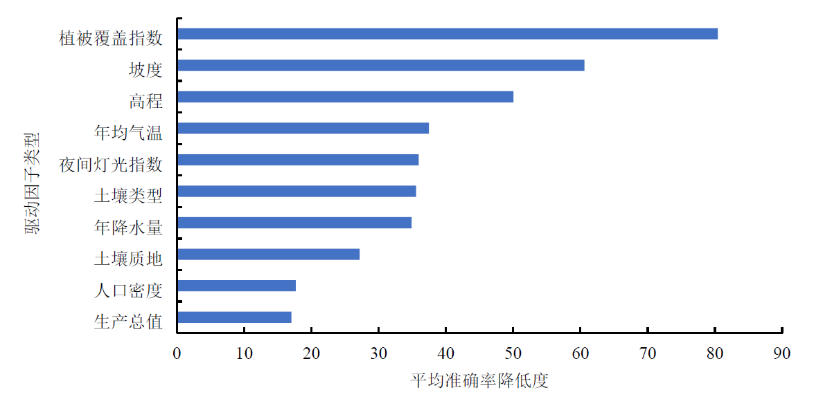
图2 驱动因子重要性排序
Figure 2 Rank of the importance of driving factors
| 判断依据 | 类型 |
|---|---|
| q(x1∩x2)<Min[q(x1), q(x2)] | 非线性减弱 |
| Min[q(x1), q(x2)]<q(x1∩x2)<Max[q(x1), q(x2)] | 单因子非线性减弱 |
| q(x1∩x2)>Max[q(x1), q(x2)] | 双因子增强 |
| q(x1∩x2)=q(x1)+q(x2) | 独立 |
| q(x1∩x2)>q(x1)+q(x2) | 非线性增强 |
表2 交互作用类型
Table 2 Types of interactions
| 判断依据 | 类型 |
|---|---|
| q(x1∩x2)<Min[q(x1), q(x2)] | 非线性减弱 |
| Min[q(x1), q(x2)]<q(x1∩x2)<Max[q(x1), q(x2)] | 单因子非线性减弱 |
| q(x1∩x2)>Max[q(x1), q(x2)] | 双因子增强 |
| q(x1∩x2)=q(x1)+q(x2) | 独立 |
| q(x1∩x2)>q(x1)+q(x2) | 非线性增强 |

图3 2005-2020年太行山区土地利用空间分布
Figure 3 Spatial distribution of land use of Taihang Mountains from 2005 to 2020
| 土地利用类型 | 2020年 | |||||||
|---|---|---|---|---|---|---|---|---|
| 耕地 | 林地 | 草地 | 水域 | 建设用地 | 未利用地 | 合计 | ||
| 2005年 | 耕地 | 44.2 | 0.865 | 4.17 | 0.069 | 0.009 | 0.002 | 49.3 |
| 林地 | 0.857 | 41.3 | 4.49 | 0 | 0 | 0 | 46.6 | |
| 草地 | 2.26 | 0.724 | 24.6 | 0 | 0 | 0.002 | 27.6 | |
| 水域 | 0.162 | 0.002 | 0.003 | 0.484 | 0.055 | 0 | 0.706 | |
| 建设用地 | 2.92 | 0.082 | 0.271 | 0.025 | 8.13 | 0.001 | 11.4 | |
| 未利用地 | 0.001 | 0 | 0.008 | 0 | 0 | 0.001 | 0.01 | |
| 合计 | 50.4 | 42.9 | 33.5 | 0.578 | 8.19 | 0.006 | 136.0 | |
表3 2005年-2020年太行山区土地利用类型面积转移矩阵
Table 3 Area transfer matrix of land use of Taihang mountains from 2005 to 2020 103 km2
| 土地利用类型 | 2020年 | |||||||
|---|---|---|---|---|---|---|---|---|
| 耕地 | 林地 | 草地 | 水域 | 建设用地 | 未利用地 | 合计 | ||
| 2005年 | 耕地 | 44.2 | 0.865 | 4.17 | 0.069 | 0.009 | 0.002 | 49.3 |
| 林地 | 0.857 | 41.3 | 4.49 | 0 | 0 | 0 | 46.6 | |
| 草地 | 2.26 | 0.724 | 24.6 | 0 | 0 | 0.002 | 27.6 | |
| 水域 | 0.162 | 0.002 | 0.003 | 0.484 | 0.055 | 0 | 0.706 | |
| 建设用地 | 2.92 | 0.082 | 0.271 | 0.025 | 8.13 | 0.001 | 11.4 | |
| 未利用地 | 0.001 | 0 | 0.008 | 0 | 0 | 0.001 | 0.01 | |
| 合计 | 50.4 | 42.9 | 33.5 | 0.578 | 8.19 | 0.006 | 136.0 | |
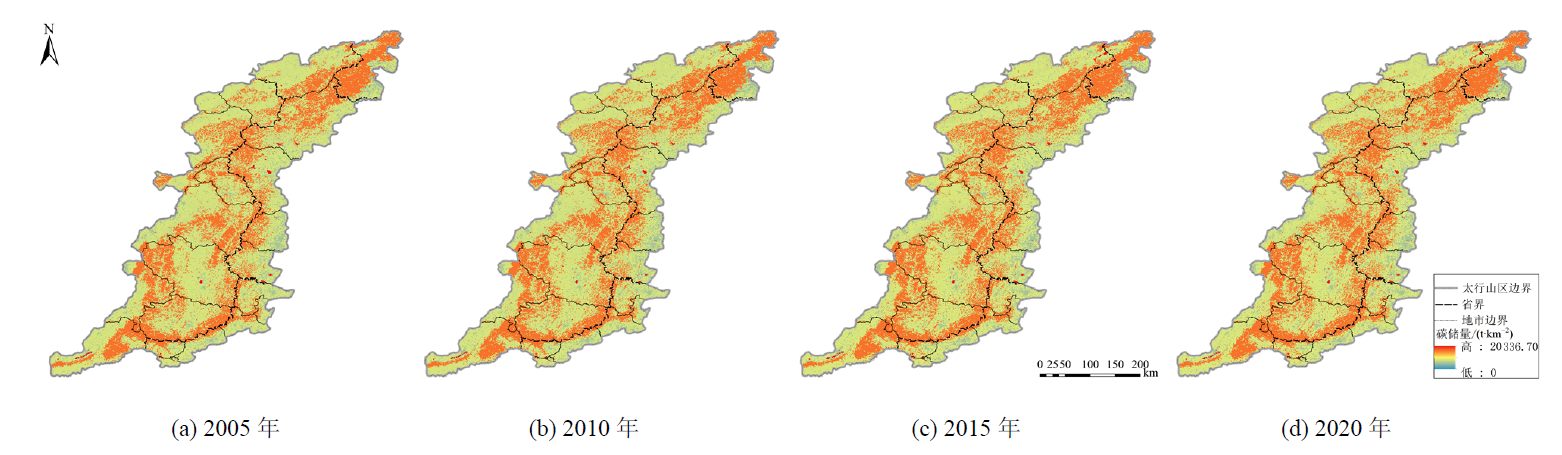
图4 2005-2020年间太行山区碳储量空间分布
Figure 4 Spatial distribution of carbon storage of Taihang Mountains from 2005 to 2020
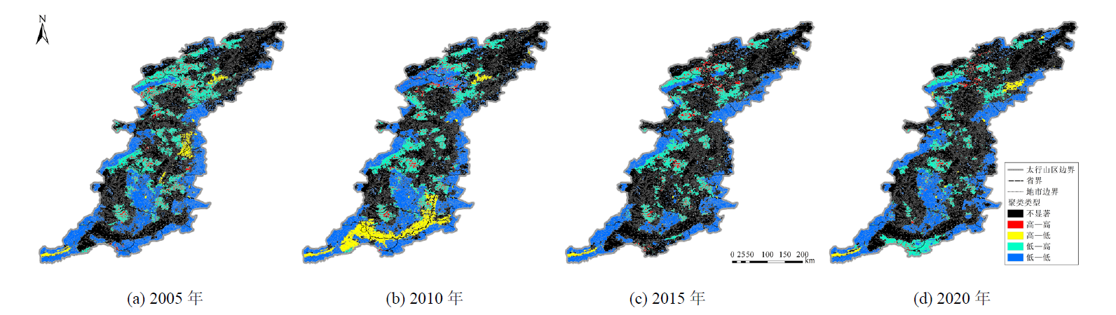
图5 2005-2020年太行山区碳储量LISA聚类
Figure 5 LISA clustering of carbon storage of Taihang Mountains from 2005 to 2020
| 土地利用 类型 | 2005-2010年 | 2010-2015年 | 2015-2020年 | 2005-2020年 | |||||||
|---|---|---|---|---|---|---|---|---|---|---|---|
| 变化量/106 t | 变化率/% | 变化量/106 t | 变化率/% | 变化量/106 t | 变化率/% | 变化量/106 t | 变化率/% | ||||
| 耕地 | −16.5 | −3.52 | −1.91 | −0.42 | 8.37 | 1.86 | −10.0 | −2.14 | |||
| 林地 | 19.1 | 2.95 | 10.9 | 1.63 | 25.4 | 3.74 | 55.4 | 8.55 | |||
| 草地 | −6.08 | −2.04 | −15.8 | −5.43 | −31.0 | −11.3 | −53.0 | −17.8 | |||
| 水域 | −0.14 | −1.39 | 1.87 | 18.6 | 0.55 | 4.6 | 2.28 | 22.3 | |||
| 建设用地 | 8.71 | 14.7 | 8.46 | 12.4 | 6.32 | 8.24 | 23.5 | 39.5 | |||
| 未利用地 | 0 | 0 | 0 | 0 | 0 | 0 | 0 | 0 | |||
| 合计 | 5.09 | 10.6 | 3.5 | 26.8 | 9.64 | 7.2 | 18.2 | 50.4 | |||
表4 太行山区各类土地利用类型碳储量变化
Table 4 Changes in carbon storage of different land use of Taihang Mountains
| 土地利用 类型 | 2005-2010年 | 2010-2015年 | 2015-2020年 | 2005-2020年 | |||||||
|---|---|---|---|---|---|---|---|---|---|---|---|
| 变化量/106 t | 变化率/% | 变化量/106 t | 变化率/% | 变化量/106 t | 变化率/% | 变化量/106 t | 变化率/% | ||||
| 耕地 | −16.5 | −3.52 | −1.91 | −0.42 | 8.37 | 1.86 | −10.0 | −2.14 | |||
| 林地 | 19.1 | 2.95 | 10.9 | 1.63 | 25.4 | 3.74 | 55.4 | 8.55 | |||
| 草地 | −6.08 | −2.04 | −15.8 | −5.43 | −31.0 | −11.3 | −53.0 | −17.8 | |||
| 水域 | −0.14 | −1.39 | 1.87 | 18.6 | 0.55 | 4.6 | 2.28 | 22.3 | |||
| 建设用地 | 8.71 | 14.7 | 8.46 | 12.4 | 6.32 | 8.24 | 23.5 | 39.5 | |||
| 未利用地 | 0 | 0 | 0 | 0 | 0 | 0 | 0 | 0 | |||
| 合计 | 5.09 | 10.6 | 3.5 | 26.8 | 9.64 | 7.2 | 18.2 | 50.4 | |||
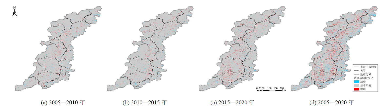
图6 2005-2020年太行山区碳储量空间变化分布
Figure 6 Spatial distribution of Carbon storage of Taihang Mountains from 2005 to 2020
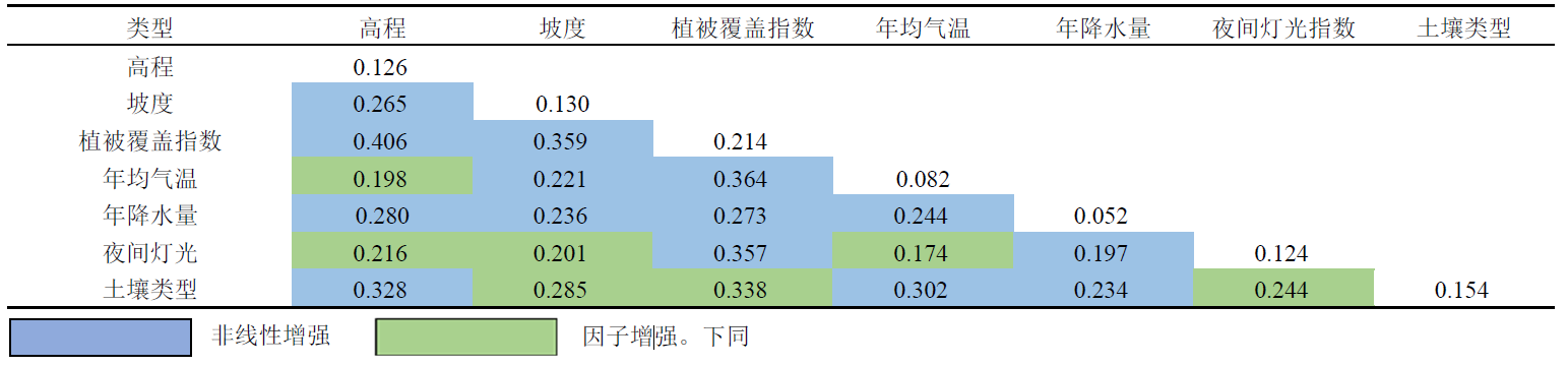 |
表5 2005年各驱动因子交互探测结果
Table 5 Interaction detection results of driving factors in 2005
| |
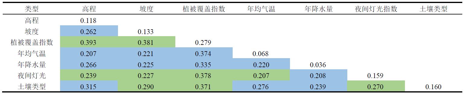 |
表6 2010年各驱动因子交互探测结果
Table 6 Interaction detection results of driving factors in 2010
| |
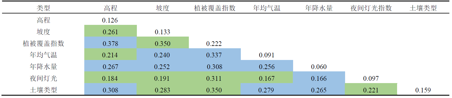 |
表7 2015年各驱动因子交互探测结果
Table 7 Interaction detection results of various factors in 2015
| |
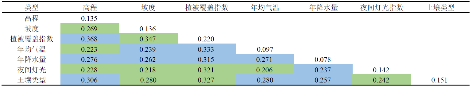 |
表8 2020年各驱动因子交互探测结果
Table 8 Interaction detection results of driving factors in 2020
| |
| [1] | ADHIKARI K, HARTEMINK A E, et al., 2015. Digital mapping of topsoil carbon content and changes in the driftless area of Wisconsin, USA[J]. Soil Science Society of America Journal, 79(1): 155-164. |
| [2] | ADAMS, A B, PONTIUS J, GALFORD G L, et al., 2018. Modeling carbon storage across a heterogeneous mixed temperate forest: the influence of forest type specificity on regional-scale carbon storage estimates[J]. Landscape Ecology, 33(4): 641-658. |
| [3] | BALASUBRAMANIAN D, ZHOU W J, JI H L, et al., 2020. Environmental and management controls of soil carbon storage in grasslands of southwestern China[J]. Journal of Environmental Management, 259(7): 109810. |
| [4] | CONTOSTA A R, LERMAN S B, XIAO J F, et al., 2020. Biogeochemical and socioeconomic drivers of above-and below-ground carbon stocks in urban residential yards of a small city[J]. Landscape and Urban Planning, 196(4): 103724. |
| [5] | DAUD N N, CHINENYENWA A S, RHYS T H, et al., 2018. Carbon sequestration in Malaysian oil palm plantations: An overview[C]//ZHAN L, CHEN Y, BOUAZZA A. 8th International Congress on Environmental Geotechnics (ICEG). Hangzhou: Springer-Verlag Singapore Pth Ltd: 49-56. |
| [6] | DANGULLA M, ABD M L, RAMLI M F, et al., 2021. Exploring urban tree diversity and carbon stocks in Zaria Metropolis, North Western Nigeria[J]. Applied Geography, 127(1): 102385. |
| [7] | GONZÁLEZ-DÍAZ P, RUIZ-BENITO P, RUIZ J G, et al., 2019. A multifactorial approach to value supporting ecosystem services in Spanish forests and its implications in a warming world[J]. Sustainability, 11(2): 1-24. |
| [8] | HOBLEY E, WILSON B, WILKIE A, et al., 2015. Drivers of soil organic carbon storage and vertical distribution in Eastern Australia[J]. Plant and Soil, 390(1-2): 111-127. |
| [9] | HE C Y, ZHANG D, HUANG Q X, et al., 2016. Assessing the potential impacts of urban expansion on regional carbon storage by linking the LUSD-urban and InVEST models[J]. Environmental Modelling and Software, 75(1): 44-58. |
| [10] | LI T, LI M Y, TIAN L, 2021. Dynamics of carbon storage and its drivers in Guangdong Province from 1979 to 2012[J]. Forests, 12(11): 1482. |
| [11] | LPATOVL D N, SHCHEGLOV A I, MANAKHOV D V, et al., 2021. Spatial variation of organic carbon stocks in peat soils and Gleyzems in the northeast of Sakhalin Island[J]. Eurasian Soil Science, 54(2): 226-237. |
| [12] | MAZARRASA I, SARNPER-VILLARREAL J, SERRANO O, et al., 2018. Habitat characteristics provide insights of carbon storage in seagrass meadows[J]. Marine Pollution Bulletin, 134(11): 106-117. |
| [13] | MOREIRA M, FONSECA C, VERGILIO M, et al., 2018. Spatial assessment of habitat conservation status in a Macaronesian island based on the InVEST model: A case study of Pico Island (Azores, Portugal)[J]. Land Use Policy, 78(11): 637-649. |
| [14] | PEREIRA O J R, MONTES C R, LUCAS Y, et al., 2015. A multi-sensor approach for mapping plant-derived carbon storage in Amazonian podzols[J]. International Journal of Remote Sensing, 36(8): 2076-2092. |
| [15] | SCHEDLBAUER J L, POLOHOVICH S, 2020. Current and future carbon storage capacity in a southeastern Pennsylvania forest[J]. Natural Areas Journal, 40(4): 300-308. |
| [16] | WIESE L, ROS I, ROZANOV A, et al., 2016. An approach to soil carbon accounting and mapping using vertical distribution functions for known soil types[J]. Geoderma, 263(1): 264-273. |
| [17] | WILLCOCK S, PHILLIPS O L, PLATTS P J, et al., 2012. Towards regional, error-bounded landscape carbon storage estimates for data-deficient areas of the world[J]. Plos One, 7(9): e44975. |
| [18] | YANG J, HUANG X, 2021. The 30 m annual land cover datasets and its dynamics in China from 1990 to 2021[J]. Zenodo, 13(8): 3907-3925. |
| [19] | 程鹏飞, 王金亮, 王雪梅, 等, 2009. 森林生态系统碳储量估算方法研究进展[J]. 林业调查规划, 34(6): 39-45. |
| CHENG P F, WANG J L, WANG X M, et al., 2009. Research progress in estimating carbon Storage of forest ecosystem[J]. Forest Inventory and Planning, 34(6): 39-45. | |
| [20] | 丛文翠, 孙小银, 2018. 基于GIS和InVEST模型的日照市固碳能力研究[J]. 水土保持通报, 38(5): 200-205. |
| CONG W C, SUN X Y, 2018. A study on carbon sequestration capacity based on GlS and InVEST model in Rizhao city[J]. Bulletin of Soil and Water Conservation, 38(5): 200-205. | |
| [21] | 蔡文良, 谢艳云, 唐雯, 2019. 海南尖峰岭热带山地雨林土壤有机碳储量和垂直分布特征[J]. 生态环境学报, 28(8): 1514-1521. |
| CAI W L, XIE Y Y, TANG W, 2019. Vertical distribution of soil organic carbon storage of tropical mountain rainforest in Jianfengling, Hainan[J]. Ecology and Environmental Sciences, 28(8): 1514-1521. | |
| [22] | 曹桃云, 2022. 基于随机森林的变量重要性研究[J]. 统计与决策, 38(4): 60-63. |
| CAO T Y, 2022. Study on the importance of variables based on random forest[J]. Statistics & Decision, 38(4): 60-63. | |
| [23] | 陈雨康, 2022. 钢铁业今年向 “双碳” 目标继续迈进[N]. 上海证券报, 01-14 (007). |
| CHEN Y K, 2022. Steel industry this year to “double carbon” target continued to move forward[N]. Shanghai Securities News, 01-14 (007). | |
| [24] | 范晨雨, 景海涛, 王莉, 等, 2020. 太行山区气候时空变化及其对植被覆盖度的影响[J]. 水土保持研究, 27(3): 146-152, 158. |
| FAN C Y, JING H T, WANG L, et al., 2020. Spatial-temporal change of climate and its relationship with vegetation coverage in Taihang Mountainous areas[J]. Research of Soil and Water Conservation, 27(3): 146-152, 158. | |
| [25] | 杜之利, 苏彤, 葛佳敏, 等, 2021. 碳中和背景下的森林碳汇及其空间溢出效应[J]. 经济研究, 56(12): 187-202. |
| DU Z L, SU T, GE J M, et al., 2021. Towards the carbon neutrality: The role of carbon sink and its spatial spillover effects[J]. Economic Research Journal, 56(12): 187-202. | |
| [26] | 高扬, 何念鹏, 汪亚峰, 2013. 生态系统固碳特征及其研究进展[J]. 自然资源学报, 28(7): 1264-1274. |
| GAO Y, HE N P, WANG Y F, 2013. Characteristics of carbon sequestration by ecosystem and progress in its research[J]. Journal of Natural Resources, 28(7): 1264-1274. | |
| [27] | 高会, 刘金铜, 朱建佳, 等, 2018. 基于可持续发展的太行山区生态系统服务垂直分类管理[J]. 自然杂志, 40(1): 47-54. |
| GAO H, LIU J T, ZHU J J, et al., 2018. Ecosystem services management based on vertical variation for sustainable development of Taihang Mountain areas[J]. Chinese Journal of Nature, 40(1): 47-54. | |
| [28] | 虎帅, 张学儒, 官冬杰, 2018. 基于InVEST模型重庆市建设用地扩张的碳储量变化分析[J]. 水土保持研究, 25(3): 323-331. |
| HU S, ZHANG X R, GUAN D J, 2018. Analysis on carbon storage change of construction land expansion in Chongqing based on InVEST model[J]. Research of Soil and Water Conservation, 25(3): 323-331. | |
| [29] | 韩玉, 丁素婷, 杨太保, 2023. 山西南部中条山生态系统碳储量时空分布及驱动因素[J]. 中国环境科学, 43(3): 1-9. |
| HAN Y, DING S T, YANG T B, 2023. Spatial and temporal distribution and driving factors of carbon storage in Zhongtiao Mountain ecosystem in southern Shanxi province[J]. China Environmental Science, 43(3): 1-9. | |
| [30] | 刘瑞, 朱道林, 2010. 基于转移矩阵的土地利用变化信息挖掘方法探讨[J]. 资源科学, 32(8): 1544-1550. |
| LIU R, ZHU D L, 2010. Methods for detecting land use changes based on the land use transition matrix[J]. Resources Science, 32(8): 1544-1550. | |
| [31] | 冷宏志, 高延利, 冯文利, 等, 2017. 土地利用现状分类[S]. 北京: 中国土地勘测规划院, 国土资源部地籍管理司(不动产登记局): 1-10. |
| LENG H Z, GAO Y L, FENG W L, et al., 2017. The Classification of Present Land Use Situation[S]. Beijing: Chinese Land Surveying and Planning Institute, Cadastral Management Department, Ministry of Land and Resources of the People's Republic of China: 1-10. | |
| [32] | 刘晓娟, 黎夏, 梁迅, 等, 2019. 基于FLUS-InVEST模型的中国未来土地利用变化及其对碳储量影响的模拟[J]. 热带地理, 39(3): 397-409. |
| LIU X J, LI X, LIANG X, et al., 2019. Simulating the change of terrestrial carbon storage in China based on the FLUS-InVEST model[J]. Tropical Geography, 39(3): 397-409. | |
| [33] | 李若玮, 叶冲冲, 王毅, 等, 2021. 基于InVEST模型的青藏高原碳储量估算及其驱动力分析[J]. 草地学报, 29(S1): 43-51. |
| LI R W, YE C C, WANG Y, et al., 2021. Carbon storage estimation and its drivering force analysis based on InVEST model in the Tibetan Plateau[J]. Acta Agrestia Sinica, 29(S1): 43-51. | |
| [34] | 李瑾璞, 夏少霞, 于秀波, 等, 2020. 基于InVEST模型的河北省陆地生态系统碳储量研究[J]. 生态与农村环境学报, 36(7): 854-861. |
| LI J P, XIA S X, YU X B, et al., 2020. Evaluation of carbon storage on terrestrial ecosystem in Hebei Province based on InVEST model[J]. Journal of Ecology and Rural Environment, 36(7): 854-861. | |
| [35] | 李茂娟, 李天奇, 朱文博, 等, 2021. 基于InVEST模型的太行山区生态系统碳储量多维变化研究[J]. 河南大学学报 (自然科学版), 51(6): 631-642, 684. |
| LI M J, LI T Q, ZHU W B, et al., 2021. Multidimensional changes of carbon storage in Taihang Mountain ecosystem based on lnVEST model[J]. Journal of Henan University (Natural Science), 51(6): 631-642, 684. | |
| [36] | 梁海, 王骏, 洪兵, 等, 2021. 减碳成效显著!南京路灯通过技术升级,助力实现双碳目标[J]. 光源与照明, 152(4): 1-3. |
| LIANG H, WANG J, HONG B, et al., 2021. Carbon reduction fruitful! Nanjing street lights through technical upgrading, help achieve the double carbon target[J]. Lamps & Lighting, 152(4): 1-3. | |
| [37] | 刘孟竹, 王彦芳, 裴宏伟, 2021. 退耕还林(草)背景下中国北方农牧交错带土地利用及碳储量变化[J]. 中国沙漠, 41(1): 174-182. |
| LIU M Z, WANG Y F, PEI H W, 2021. The changes of land use and carbon storage in the northern farming-pastoral ecotone under the background of returning farmland to forest (grass)[J]. Journal of Desert Research, 41(1): 174-182. | |
| [38] | 李春亮, 王翔, 张炜, 等, 2022. 黄土高原西段表层土壤有机碳储量及时空变化规律[J]. 现代地质, 36(2): 655-661. |
| LI C L, WANG X, ZHANG W, et al., 2022. Topsoil organic carbon storage and its spatial and temporal variation in the western loess plateau[J]. Geoscience, 36(2): 655-661. | |
| [39] | 任向宁, 董玉祥, 王秋香, 2018. 珠三角核心区农田耕层土壤有机碳库储量时空变化特征及其影响因素识别[J]. 热带地理, 38(5): 668-677. |
| REN X N, DONG Y X, WANG Q X, 2018. Temporal and spatial variation of soil organic carbon storage in the core area of Pearl River Delta and identification of influencing factors[J]. Tropical Geography, 38(5): 668-677. | |
| [40] | 沈会涛, 王晓学, 赵艳霞, 等, 2017. 河北省太行山区10 a生核桃林生态系统的碳氮储量[J]. 四川农业大学学报, 35(2): 208-212. |
| SHEN H T, WANG X X, ZHAO Y X, et al., 2017. Organic carbon and nitrogen storage in a 10-year-old Juglans regia ecosystem in the Taihang Mountain area of Hebei province[J]. Journal of Sichuan Agricultural University, 35(2): 208-212. | |
| [41] | 史婷婷, 陈植华, 王宁涛, 等, 2011. 香溪河流域土壤有机碳储量影响因素的空间相关性分析[J]. 中国岩溶, 30(4): 422-431. |
| SHI T T, CHEN Z H, WANG N T, et al., 2011. Spatial correlation analysis on soil organic carbon and the influencing factors in the Xiangxi River basin[J]. Carsologica Sinica, 30(4): 422-431. | |
| [42] | 孙毅兵, 2021. 森林生态系统土壤碳影响因素研究[J]. 林业勘查设计, 50(3): 73-75. |
| SUN Y B, 2021. Research on influencing factors of soil carbon in forest ecosystem[J]. Forest Investigation Design, 50(3): 73-75. | |
| [43] | 唐尧, 祝炜平, 张慧, 等, 2015. InVEST模型原理及其应用研究进展[J]. 生态科学, 34(3): 204-208. |
| TANG Y, ZHU W P, ZHANG H, et al., 2015. A review on principle and application of the InVEST model[J]. Ecological Science, 34(3): 204-208. | |
| [44] | 唐志明, 刘炳响, 屈宇, 2020. 河北太行山区典型水土保持林乔木层生物量及碳储量研究[J]. 林业资源管理, 285(1): 102-107, 135. |
| TANG Z M, LIU B X, QU Y, 2020. Study on biomass and carbon storage of arbor layers in typical soil and water conservation forests in Taihang Mountain range in Hebei Province[J]. Forest Resources Management, 285(1): 102-107, 135. | |
| [45] | 王劲峰, 徐成东, 2017. 地理探测器:原理与展望[J]. 地理学报, 72(1): 116-134. |
| WANG J F, XU C D, 2017. Geodetector: Principle and prospective[J]. Acta Geographica Sinica, 72(1): 116-134. | |
| [46] | 吴恒, 胥辉, 2021. 森林植被碳密度遥感反演和校准研究[J]. 林业资源管理, 281(6): 43-51. |
| WU H, XU H, 2021. Remote sensing retrieval and calibration of forest vegetation carbon density based on time-series data[J]. Forest Resources Management, 281(6): 43-51. | |
| [47] | 王超越, 郭先华, 郭莉, 等, 2022. 基于FLUS-InVEST的西北地区土地利用变化及其对碳储量的影响-以呼包鄂榆城市群为例[J]. 生态环境学报, 31(8): 1667-1679. |
| WANG C Y, GUO X H, GUO L, et al., 2022. Land use change and its impact on carbon storage in northwest China based on FLUS-Invest: A case study of Hu-Bao-Er-Yu urban agglomeration[J]. Ecology and Environmental Sciences, 31(8): 1667-1679. | |
| [48] | 王天福, 龚直文, 邓元杰, 2022. 基于土地利用变化的陕西省植被碳汇提质增效优先区识别[J]. 自然资源学报, 37(5): 1214-1232. |
| WANG T F, GONG Z W, DENG Y J, 2022. Identification of priority areas for improving quality and efficiency of vegetation carbon sinks in Shaanxi province based on land use change[J]. Journal of Natural Resources, 37(5): 1214-1232. | |
| [49] | 徐丽, 何念鹏, 于贵瑞, 2019. 2010s中国陆地生态系统碳密度数据集[J]. 中国科学数据 (中英文网络版), 4(1): 90-96. |
| XU L, HE N P, YU G R, 2019. A dataset of carbon density in Chinese terrestrial ecosystems (2010s)[J]. China Scientific Data, 4(1): 90-96. | |
| [50] | 徐飞, 谢岸辉, 2022. 湖南工业节能减碳成效显著[J]. 大众用电, 37(4): 38. |
| XU F, XIE A H, 2022. Hunan industry has achieved remarkable results in energy saving and carbon reduction[J]. Popular Utilization of Electricity, 37(4): 38. | |
| [51] | 应天玉, 李明泽, 范文义, 2009. 哈尔滨城市森林碳储量的估算[J]. 东北林业大学学报, 37(9): 33-35. |
| YING T Y, LI M Z, FAN W Y, 2009. Estimation of carbon storage of urban forests in Harbin[J]. Journal of Northeast Forestry University, 37(9): 33-35. | |
| [52] | 尤海丹, 毕君, 王超, 等, 2018. 河北小五台山不同海拔白桦林土壤有机碳密度分布特征及影响因素[J]. 生态环境学报, 27(3): 432-437. |
| YOU H D, BI J, WANG C, et al., 2018. Altitudinal distribution rule of Betula platyphylla forest's soil organic carbon density and its influencing factors in Xiaowutai Mountain in Hebei[J]. Ecology and Environmental Sciences, 27(3): 432-437. | |
| [53] | 杨小琬, 张丽君, 秦耀辰, 等, 2022. 1995年以来黄河下游碳储量时空变化及驱动因素[J]. 河南大学学报 (自然科学版), 52(1): 20-33. |
| YANG X W, ZHANG L J, QIN Y C, et al., 2022. Temporal and spatial variation and driving factors of carbon storage in the lower Yellow River since 1995[J]. Journal of Henan University: Natural Science, 52(1): 20-33. | |
| [54] | 张宏芝, 陆贵巧, 原占国, 等, 2005. 太行山区天然次生林碳储量的研究[J]. 河北林果研究, 20(1): 11-13. |
| ZHANG H Z, LU G Q, YUAN Z G, et al., 2005. Estimation of carbon cycling of natural secondary forest in Taihang Mountain[J]. Forestry and Ecological Sciences, 20(1): 11-13. | |
| [55] | 朱真令, 麻万诸, 龙文莉, 等, 2015. 杭州余杭区农田耕层土壤有机碳空间分布特征及其影响因素[J]. 浙江农业学报, 27(11): 1990-1997. |
| ZHU Z L, MA W Z, LONG W L, et al., 2015. Spatial distribution characteristics of topsoil organic carbon in farmland and its influencing factors in Yuhang District, Hangzhou City[J]. Acta Agriculturae Zhejiangensis, 27(11): 1990-1997. | |
| [56] | 张文华, 贾志斌, 卓义, 等, 2016. InVEST模型对锡林郭勒草原碳储量研究的适用性分析[J]. 地球环境学报, 7(1): 87-96. |
| ZHANG W H, JIA Z B, ZHUO Y, et al., 2016. Applicability research on carbon storage in the Xilin Gol Grassland by InVEST model[J]. Journal of Earth Environment, 7(1): 87-96. | |
| [57] | 张志堂, 2017. 上海城市典型绿地的碳汇估算[J]. 绿色科技 (15): 60-62. |
| ZHANG Z T, 2017. Carbon sequestration estimation of typical urban green land in Shanghai[J]. Journal of Green Science and Technology (15): 60-62. | |
| [58] | 张桂莲, 2021. 基于遥感估算的上海城市森林碳储量空间分布特征[J]. 生态环境学报, 30(9): 1777-1786. |
| ZHANG G L, 2021. Spatial distribution characteristics of carbon storage of urban forests in Shanghai based on remote sensing estimation[J]. Ecology and Environmental Sciences, 30(9): 1777-1786. | |
| [59] | 张徐, 李云霞, 吕春娟, 等, 2022. 基于InVEST模型的生态系统服务功能应用研究进展[J]. 生态科学, 41(1): 237-242. |
| ZHANG X, LI Y X, LÜ C J, et al., 2022. Research progress on application of ecosystem service functions based on InVEST model[J]. Ecological Science, 41(1): 237-242. | |
| [60] | 张志国, 班高晗, 2021. 土地利用变化驱动下洛阳市生态系统碳储量时空变异[J]. 江苏农业科学, 49(14): 226-230. |
| ZHANG Z G, BAN G H, 2021. Temporal and spatial variation of ecosystem carbon storage based on land use change in Luoyang City[J]. Jiangsu Agricultural Sciences, 49(14): 226-230. | |
| [61] | 郑树峰, 王丽萍, 臧淑英, 2021. 大兴安岭天保工程区生态系统服务变化研究[J]. 地理科学, 41(7): 1295-1302. |
| ZHENG S F, WANG L P, ZANG S Y, 2021. The change of ecosystem services of natural forest protection project regions in the Da Hinggan Mountains[J]. Scientia Geographica Sinica, 41(7): 1295-1302. | |
| [62] | 赵康伟, 张士然, 孔庆泽, 2022. 数据赋能显成效-双碳建设促发展[J]. 华北电业, 266(4): 19-21. |
| ZHAO K W, ZHANG S R, KONG Q Z, 2022. Data empowerment results-Dual carbon construction promotes development[J]. North China Power, 266(4): 19-21. | |
| [63] | 朱丽亚, 胡克, 孙爽, 等, 2022. 基于InVEST模型的辽宁省海岸带碳储量时空变化研究[J]. 现代地质, 36(1): 96-104. |
| ZHU L Y, HU K, SUN S, et al., 2022. Research on the spatiotemporal variation of carbon storage in the coastal zone of Liaoning province based on InVEST model[J]. Geoscience, 36(1): 96-104. |
| [1] | 周玉祥, 赵玉, 聂仁东, 丁丁, 郭立华, 周佳峥. 下辽河平原土地沙漠化程度及预测研究[J]. 生态环境学报, 2023, 32(6): 1133-1139. |
| [2] | 王琳, 卫伟. 黄土高原典型县域生态系统服务变化特征及驱动因素[J]. 生态环境学报, 2023, 32(6): 1140-1148. |
| [3] | 李建辉, 党争, 陈琳. 黄河几字弯都市圈PM2.5时空特征及影响因素分析[J]. 生态环境学报, 2023, 32(4): 697-705. |
| [4] | 张平江, 党国锋. 基于MCR模型与蚁群算法的洮河流域生态安全格局构建[J]. 生态环境学报, 2023, 32(3): 481-491. |
| [5] | 陈治中, 昝梅, 杨雪峰, 董煜. 新疆森林植被碳储量预测研究[J]. 生态环境学报, 2023, 32(2): 226-234. |
| [6] | 付蓉, 武新梅, 陈斌. 城市地表温度空间分异及驱动因子差异性分析——以合肥市为例[J]. 生态环境学报, 2023, 32(1): 110-122. |
| [7] | 郑晓豪, 陈颖彪, 郑子豪, 郭城, 黄卓男, 周泳诗. 湖北省生态系统服务价值动态变化及其影响因素演变[J]. 生态环境学报, 2023, 32(1): 195-206. |
| [8] | 陈科屹, 王建军, 何友均, 张立文. 黑龙江大兴安岭重点国有林区森林碳储量及固碳潜力评估[J]. 生态环境学报, 2022, 31(9): 1725-1734. |
| [9] | 吴胜义, 王飞, 徐干君, 马浩, 党禹杰, 吴菲. 川西北高山峡谷区森林碳储量及空间分布研究--以四川洛须自然保护区为例[J]. 生态环境学报, 2022, 31(9): 1735-1744. |
| [10] | 陈乐, 卫伟. 西北旱区典型流域土地利用与生境质量的时空演变特征[J]. 生态环境学报, 2022, 31(9): 1909-1918. |
| [11] | 王超越, 郭先华, 郭莉, 白丽芳, 夏利林, 王春博, 李廷真. 基于FLUS-InVEST的西北地区土地利用变化及其对碳储量的影响——以呼包鄂榆城市群为例[J]. 生态环境学报, 2022, 31(8): 1667-1679. |
| [12] | 陈文裕, 夏丽华, 徐国良, 余世钦, 陈行, 陈金凤. 2000—2020年珠江流域NDVI动态变化及影响因素研究[J]. 生态环境学报, 2022, 31(7): 1306-1316. |
| [13] | 李梦华, 韩颖娟, 赵慧, 王云霞. 基于地理探测器的宁夏植被覆盖度时空变化特征及其驱动因子分析[J]. 生态环境学报, 2022, 31(7): 1317-1325. |
| [14] | 杜雪, 王海燕, 邹佳何, 孟海, 赵晗, 崔雪, 董齐琪. 长白山北坡云冷杉阔叶混交林土壤有机碳分布特征及其影响因素[J]. 生态环境学报, 2022, 31(4): 663-669. |
| [15] | 高思琦, 董国涛, 蒋晓辉, 聂桐, 郭欣伟, 党素珍, 李心宇, 李昊洋. 黄河源植被覆盖度变化及空间分布自然驱动力分析[J]. 生态环境学报, 2022, 31(3): 429-439. |
| 阅读次数 | ||||||
|
全文 |
|
|||||
|
摘要 |
|
|||||