生态环境学报 ›› 2023, Vol. 32 ›› Issue (3): 481-491.DOI: 10.16258/j.cnki.1674-5906.2023.03.006
张平江( ), 党国锋*()
收稿日期:2022-11-17
出版日期:2023-03-18
发布日期:2023-06-02
通讯作者:
*党国锋(1979年生),男,副教授,硕士,研究方向为空间分析与应用。E-mial: nwdgf@163.com作者简介:张平江(1998年生)男,硕士研究生,研究方向为生态系统服务。E-mail: 2424589936@qq.com
基金资助:
ZHANG Pingjiang(), DANG Guofeng*()
Received:2022-11-17
Online:2023-03-18
Published:2023-06-02
摘要:
生态安全格局的构建是保障地区生态安全的根本措施,是促进地区经济可持续发展的关键。洮河流域作为黄河上游重要的生态功能区,具有涵养水源、保持水土和生态安全屏障等重要生态功能,对黄河流域生态保护和高质量发展意义重大。受自然和人为因素双重影响,其生态环境脆弱敏感。关于该区域生态环境保护与修复的研究还不够全面,故选择洮河流域为研究区。基于洮河流域的生态特征,将生态系统服务重要性、生态敏感性和景观连通性的评价结果叠加分析,进行生态源地识别;采用最小累积阻力模型与蚁群算法并结合核密度分析方法,识别生态廊道空间范围;采用水文分析法识别生态节点,构建洮河流域生态安全格局。结果表明,(1)洮河流域的生态系统服务重要与极重要区域面积之和约为3.124×10⁴ km2,约占研究区面积的69.02%,说明洮河流域生态系统服务价值较高;洮河流域生态敏感性主要以一般敏感和中等敏感为主,总面积约为2.753×10⁴ km2,约占研究区总面积的60.81%。(2)景观连通性极重要与重要区域面积为2.022×10⁴ km2,约占研究区总面积比例高达44.67%,表明区域景观连通性整体水平较高,但空间分布上不均衡。(3)构建出面积2.174×10⁴ km2的37个生态源地;长度2.649×10³ km、面积6.671×10³ km2的49条生态廊道;38个生态节点的点线面网状结构的生态安全格局。研究结果以期为洮河流域生态环境治理与恢复以及区域可持续发展规划提供相关依据。
中图分类号:
张平江, 党国锋. 基于MCR模型与蚁群算法的洮河流域生态安全格局构建[J]. 生态环境学报, 2023, 32(3): 481-491.
ZHANG Pingjiang, DANG Guofeng. Construction of Ecological Security Pattern of Tao River Basin Based on MCR Model and ant Colony Algorithm[J]. Ecology and Environment, 2023, 32(3): 481-491.
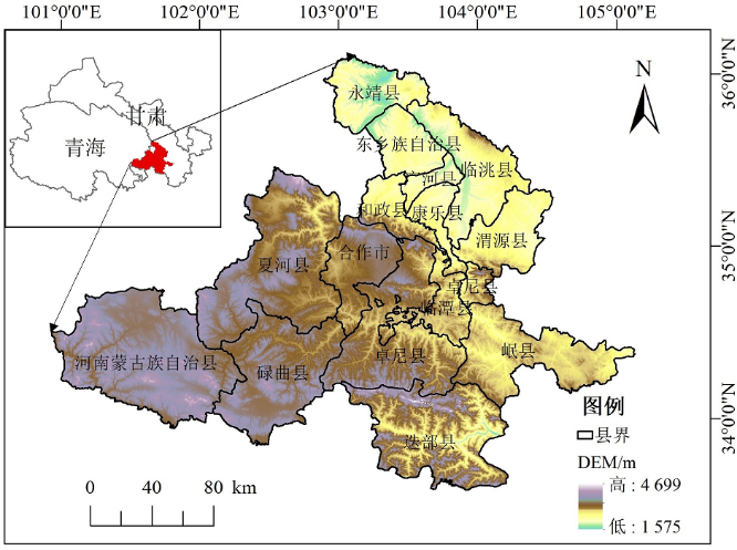
图1 洮河流域区位图
Figure 1 Location map of the Tao River Basin
| 阻力因子 | 权重 |
|---|---|
| 高程 | 0.09 |
| 坡度 | 0.16 |
| 坡向 | 0.13 |
| 植被覆盖度 | 0.13 |
| 土地利用类型 | 0.21 |
| 距水域距离 | 0.18 |
| 距建成区距离 | 0.05 |
| 距道路距离 | 0.05 |
表1 生态扩张阻力因子
Table 1 Ecological expansion resistance factor
| 阻力因子 | 权重 |
|---|---|
| 高程 | 0.09 |
| 坡度 | 0.16 |
| 坡向 | 0.13 |
| 植被覆盖度 | 0.13 |
| 土地利用类型 | 0.21 |
| 距水域距离 | 0.18 |
| 距建成区距离 | 0.05 |
| 距道路距离 | 0.05 |
| 生态系统服务重要性 | 生物多样性保护 | 土壤保持 | 水源涵养 | 固碳释氧 | |||||||
|---|---|---|---|---|---|---|---|---|---|---|---|
| 面积/km² | 比例/% | 面积/km² | 比例/% | 面积/km² | 比例/% | 面积/km² | 比例/% | ||||
| 不重要 | 9742 | 21.52 | 37931.25 | 83.79 | 6662.53 | 14.72 | 472.5 | 1.04 | |||
| 一般重要 | 13584.75 | 30.01 | 6184.75 | 13.66 | 7426.33 | 16.40 | 474.75 | 1.05 | |||
| 中等重要 | 1323.5 | 2.92 | 827.5 | 1.83 | 10720.11 | 23.68 | 64.18 | 0.14 | |||
| 重要 | 20136 | 44.48 | 231.25 | 0.51 | 14064.97 | 31.07 | 30674.5 | 67.76 | |||
| 极重要 | 484.43 | 1.07 | 95.63 | 0.21 | 6396.75 | 14.13 | 13584.75 | 30.01 | |||
表2 生态系统服务重要性评价结果
Table 2 Results of the evaluation of the importance of ecosystem service
| 生态系统服务重要性 | 生物多样性保护 | 土壤保持 | 水源涵养 | 固碳释氧 | |||||||
|---|---|---|---|---|---|---|---|---|---|---|---|
| 面积/km² | 比例/% | 面积/km² | 比例/% | 面积/km² | 比例/% | 面积/km² | 比例/% | ||||
| 不重要 | 9742 | 21.52 | 37931.25 | 83.79 | 6662.53 | 14.72 | 472.5 | 1.04 | |||
| 一般重要 | 13584.75 | 30.01 | 6184.75 | 13.66 | 7426.33 | 16.40 | 474.75 | 1.05 | |||
| 中等重要 | 1323.5 | 2.92 | 827.5 | 1.83 | 10720.11 | 23.68 | 64.18 | 0.14 | |||
| 重要 | 20136 | 44.48 | 231.25 | 0.51 | 14064.97 | 31.07 | 30674.5 | 67.76 | |||
| 极重要 | 484.43 | 1.07 | 95.63 | 0.21 | 6396.75 | 14.13 | 13584.75 | 30.01 | |||

图2 生态系统服务重要性评价结果
Figure 2 Results of the evaluation of the importance of ecosystem service
| 生态敏感性 | 水土流失敏感性 | 地质灾害敏感性 | |||
|---|---|---|---|---|---|
| 面积/km² | 比例/% | 面积/km² | 比例/% | ||
| 不敏感 | 1874.76 | 4.14 | 7097.17 | 15.68 | |
| 一般敏感 | 11926.95 | 26.35 | 16114.75 | 35.60 | |
| 中等敏感 | 13835.62 | 30.56 | 11606.34 | 25.64 | |
| 敏感 | 11705.42 | 25.86 | 8885.04 | 19.63 | |
| 极敏感 | 5927.94 | 13.09 | 1567.38 | 3.46 | |
表3 生态敏感性评价结果
Table 3 Results of ecological sensitivity evaluation
| 生态敏感性 | 水土流失敏感性 | 地质灾害敏感性 | |||
|---|---|---|---|---|---|
| 面积/km² | 比例/% | 面积/km² | 比例/% | ||
| 不敏感 | 1874.76 | 4.14 | 7097.17 | 15.68 | |
| 一般敏感 | 11926.95 | 26.35 | 16114.75 | 35.60 | |
| 中等敏感 | 13835.62 | 30.56 | 11606.34 | 25.64 | |
| 敏感 | 11705.42 | 25.86 | 8885.04 | 19.63 | |
| 极敏感 | 5927.94 | 13.09 | 1567.38 | 3.46 | |
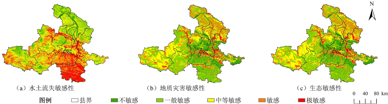
图3 生态敏感性评价结果
Figure 3 Results of ecological sensitivity evaluation
| 景观连通性评价 | 面积/km² | 百分比/% |
|---|---|---|
| 不重要 | 21412.87 | 47.30 |
| 一般重要 | 503.53 | 1.11 |
| 中等重要 | 2784.06 | 6.15 |
| 重要 | 490.17 | 1.08 |
| 极重要 | 20080.05 | 44.36 |
表4 景观连通评价结果
Table 4 Results of landscape connectivity evaluation
| 景观连通性评价 | 面积/km² | 百分比/% |
|---|---|---|
| 不重要 | 21412.87 | 47.30 |
| 一般重要 | 503.53 | 1.11 |
| 中等重要 | 2784.06 | 6.15 |
| 重要 | 490.17 | 1.08 |
| 极重要 | 20080.05 | 44.36 |
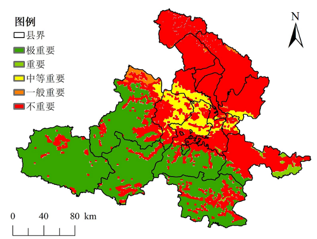
图4 景观连通性评价结果
Figure 4 Results of landscape connectivity evaluation
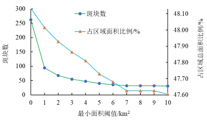
图5 生态源地斑块最小面积阈值设定的影响
Figure 5 Impact of the minimum size threshold of ecological source patches
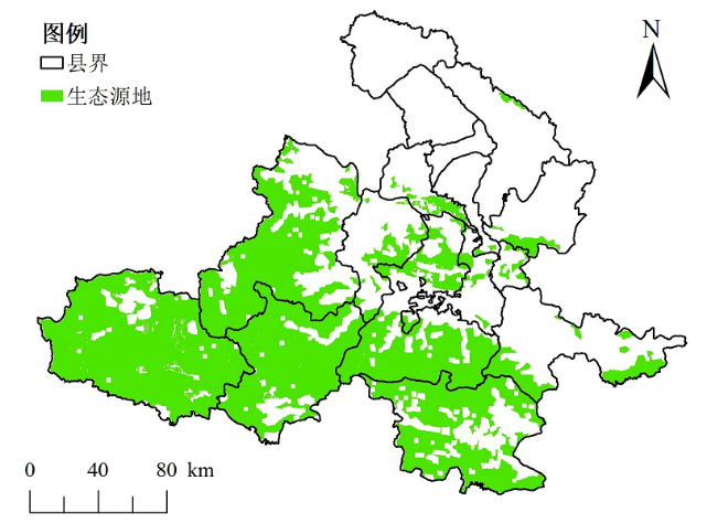
图6 生态源地选取结果
Figure 6 Results of ecological source area selection
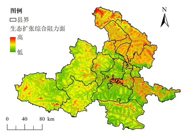
图7 生态扩张综合阻力面
Figure 7 Eco-expansion integrated resistance surface
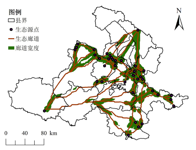
图8 生态廊道识别
Figure 8 Ecological Corridor Identification
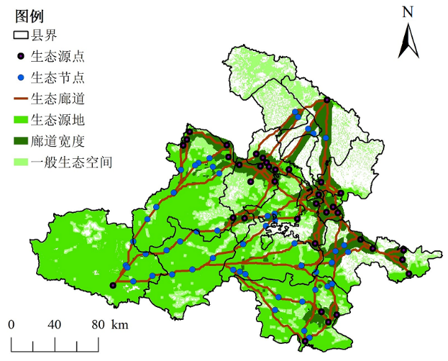
图9 生态安全格局构建
Figure 9 Ecological security pattern construction
| [1] |
HEATHER L R, LESLIE B, BURNELL C F, et al., 2020. Implications of climate change for managing urban green infrastructure: An Indiana, US case study[J]. Climatic Change, 163: 1967-1984.
DOI |
| [2] |
JAN S, STEVEN B, KATRIEN V D B, et al., 2017. Quantification of the potential impact of nature conservation on ecosystem services supply in the Flemish Region: A cascade modelling approach[J]. Ecosystem Services, 24: 124-137.
DOI URL |
| [3] |
KEVAN B M, YASUYO M, VIVEKS S, et al., 2019. Urban-rural surface temperature deviation and intra-urban variations contained by an urban growth boundary[J]. Remote Sensing, 11(22): 2683.
DOI URL |
| [4] | PENG J, ZHAO S, DONG J, et al., 2019. Applying ant colony algorithm to identify ecological security patterns in megacities[J]. Environmental Modelling & Software, 117(1): 214-222. |
| [5] |
SUN J, SOUTHWORTH J, 2013. Indicating structural connectivity in Amazonian rainforests from 1986 to 2010 using morphological image processing analysis[J]. International Journal of Remote Sensing, 34(14): 5187-5200.
DOI URL |
| [6] | 陈利顶, 傅伯杰, 赵文武, 2006. “源” “汇”景观理论及其生态学意义[J]. 生态学报, 26(5): 1444-1449. |
| CHEN L D, FU B J, ZHAO W W, 2006. Source-sink landscape theory and its ecological significance[J]. Acta Ecological Sinica, 26(5): 1444-1449. | |
| [7] | 迟妍妍, 许开鹏, 王晶晶, 等, 2018. 京津冀地区生态空间识别研究[J]. 生态学报, 38(23): 8555-8563. |
| CHI Y Y, XU K P, WANG J J, et al., 2018. Identifying regional ecological space in Beijing, Tianjin, and Hebei[J]. Acta Ecologica Sinica, 38(23): 8555-8563. | |
| [8] | 成文青, 陶宇, 吴未, 等, 2020. 基于MSPA—连接度—空间句法的生态保护空间及优先级识别——以苏锡常地区为例[J]. 生态学报, 40(5): 1789-1798. |
| CHENG W Q, TAO Y, WU W, et al., 2020. Priority evaluation of ecological protect areas based on MSPA, landscape connectivity, and spatial syntax methods in the Su-Xi-Chang Region[J]. Acta Ecologica Sinica, 40(5): 1789-1798. | |
| [9] | 崔明义, 2006. 基于蚁群算法的GIS数据拓扑空间关系描述[J]. 计算机工程与应用, 42(23): 179-182. |
| CUI M Y, 2006. Description of topological spatial relationship on GIS data based on ant colony algorithms[J]. Computer Engineering and Applications, 42(23): 179-182. | |
| [10] | 方臣, 匡华, 贾琦琪, 等, 2022. 基于生态系统服务重要性和生态敏感性的武汉市生态安全格局评价[J]. 环境工程技术学报, 12(5): 1446-1454. |
| FANG C, KUANG H, JIA Q Q, et al., 2022. Evaluation of ecological security pattern in Wuhan City based on the importance of ecosystem services and ecological sensitivity[J]. Journal of Environmental Engineering Technology, 12(5): 1446-1454. | |
| [11] | 付梦娣, 罗建武, 田瑜, 等, 2018. 基于最小累积阻力模型的自然保护区网络构建与优化——以秦岭地区为例[J]. 生态学杂志, 37(4): 1135-1143. |
| FU M D, LUO J W, TIAN Y, et al., 2018. Establishment and fine-tuning of nature reserve networks based on minimum cumulative resistance model: A case study of Mountain Qinling region[J]. Journal of Ecology, 37(4): 1135-1143. | |
| [12] | 姜虹, 张子墨, 徐子涵, 等, 2022. 整合多重生态保护目标的广东省生态安全格局构建[J]. 生态学报, 42(5): 1981-1992. |
| JIANG H, ZHANG Z M, XU Z H, et al., 2022. Construction of ecological security pattern integrating multiple ecological protection objectives in Guangdong Province[J]. Acta Ecologica Sinica, 42(5): 1981-1992. | |
| [13] | 景艳宾, 孙旭, 刘军, 等, 2021. 基于MCR模型的内蒙古鄂托克旗生态廊道构建[J]. 水土保持通报, 41(2): 170-177. |
| JING Y B, SUN X, LIU J, et al., 2021. Construction of ecological corridor in Etuoke Banner of Inner Mongolia based on MCR model[J]. Bulletin of Soil and Water Conservation, 41(2): 170-177. | |
| [14] | 李瑶, 李久林, 储金龙, 2022. 基于电路理论的金寨县生态安全格局构建[J]. 生态科学, 41(2): 227-236. |
| LI Y, LI J L, CHU J L, 2022. Construction of ecological security pattern based on circuit theory in Jinzhai County[J]. Ecological Science, 41(2): 227-236. | |
| [15] | 刘焱序, 于丹丹, 傅伯杰, 等, 2020. 生物多样性与生态系统服务情景模拟研究进展[J]. 生态学报, 40(17): 5863-5873. |
| LIU Y X, YU D D, FU B J, et al., 2020. Research progress on the biodiversity and ecosystem service scenario simulation[J]. Acta Ecologica Sinica, 40(17): 5863-5873. | |
| [16] | 彭建, 郭小楠, 胡熠娜, 等, 2017b. 基于地质灾害敏感性的山地生态安全格局构建——以云南省玉溪市为例[J]. 应用生态学报, 28(2): 627-635. |
| PENG J, GUO X N, HU Y N, et al., 2017b. Constructing ecological security patterns in mountain areas based on geological disaster sensitivity: A case study in Yuxi City, Yunnan Province, China[J]. Chinese Journal of Applied Ecology, 28(2): 627-635. | |
| [17] |
彭建, 贾靖雷, 胡熠娜, 等, 2018. 基于地表湿润指数的农牧交错带地区生态安全格局构建——以内蒙古自治区杭锦旗为例[J]. 应用生态学报, 29(6): 1990-1998.
DOI |
| PENG J, JIA J L, HU Y N, et al., 2018. Construction of ecological security pattern in the agro-pastoral ecotone based on surface humid index: A case study of Hangjin Banner, Inner Mongolia Autonomous Region, China[J]. Chinese Journal of Applied Ecology, 29(6): 1990-1998. | |
| [18] | 彭建, 赵会娟, 刘焱序, 等, 2017a. 区域生态安全格局构建研究进展与展望[J]. 地理研究, 36(3): 407-419. |
| PENG J, ZHAO H J, LIU Y X, et al., 2017a. Research progress and prospect on regional ecological security pattern construction[J]. Geographical Research, 36(3): 407-419. | |
| [19] | 潘竟虎, 王云, 2021. 基于CVOR和电路理论的讨赖河流域生态安全评价及生态格局优化[J]. 生态学报, 41(7): 2582-2595. |
| PAN J H, WANG Y, 2021. Ecological security evaluation and ecological pattern optimization in Taolai River Basin based on CVOR and circuit theory[J]. Acta Ecologica Sinica, 41(7): 2582-2595. | |
| [20] | 任玺锦, 裴婷婷, 陈英, 等, 2021. 基于碳密度修正的甘肃省土地利用变化对碳;储量的影响[J]. 生态科学, 40(4): 66-74. |
| REN X J, PEI T T, CHEN Y, et al., 2021. Impact of land use change on carbon storage in Gansu Province based on carbon density correction[J]. Ecological Science, 40(4): 66-74. | |
| [21] | 王浩, 马星, 杜勇, 2021. 基于生态系统服务重要性和生态敏感性的广东省生态安全格局构建[J]. 生态学报, 41(5): 1705-1715. |
| WANG H, MA X, DU Y, 2021. Constructing ecological security patterns based on ecological service importance and ecological sensitivity in Guangdong Province[J]. Acta Ecologica Sinica, 41(5): 1705-1715. | |
| [22] | 杨凯, 曹银贵, 冯喆, 等, 2021. 基于最小累积阻力模型的生态安全格局构建研究进展[J]. 生态与农村环境学报, 37(5): 555-565. |
| YANG K, CAO Y G, FENG Z, et al., 2021. Research progress of ecological security pattern construction based on minimum cumulative resistance model[J]. Journal of Ecology and Rural Environment, 37(5): 555-565. | |
| [23] | 尹海伟, 孔繁花, 祈毅, 等, 2011. 湖南省城市群生态网络构建与优化[J]. 生态学报, 31(10): 2863-2874. |
| YIN H W, KONG F H, QI Y, et al., 2011. Developing and optimizing ecological networks in urban agglomeration of Hunan Province, China[J]. Acta Ecologica Sinica, 31(10): 2863-2874. | |
| [24] | 易浪, 孙颖, 尹少华, 等, 2022. 生态安全格局构建: 概念、框架与展望[J]. 生态环境学报, 231(4): 845-856. |
| YI L, SUN Y, YIN S H, et al., 2022. Construction of ecological security pattern: Concept, framework and prospect[J]. Ecology and Environmental Sciences, 231(4): 845-856. | |
| [25] | 俞孔坚, 1998. 景观生态战略点识别方法与理论地理学的表面模型[J]. 地理学报, 53(12): 11-20. |
| YU K J, 1998. Ecologically strategic points in landscape and surface model[J]. Acta Geographica Sinica, 53(12): 11-20. | |
| [26] | 张豆, 渠丽萍, 张桀滈, 2019. 基于生态供需视角的生态安全格局构建与优化——以长三角地区为例[J]. 生态学报, 39(20): 7525-7537. |
| ZHANG D, QU L P, ZHANG J H, 2019. Ecological security pattern construction method based on the perspective of ecological supply and demand: a case study of Yangtze River Delta[J]. Acta Ecologica Sinica, 39(20): 7525-7537. | |
| [27] | 赵诚诚, 潘竟虎, 2022. 基于供需视角的黄河流域甘肃段生态安全格局识别与优化[J]. 生态学报, 42(17): 6973-6984. |
| ZHAO C C, PAN J H, 2022. Ecological safety pattern identification and optimization based on the ecological supply and demand in Gansu section of the Yellow River Basin[J]. Acta Ecologica Sinica, 42(17): 6973-6984. | |
| [28] |
赵宇豪, 罗宇航, 易腾云, 等, 2022. 基于生态系统服务供需匹配的深圳市生态安全格局构建[J]. 应用生态学报, 33(9): 2475-2484.
DOI |
|
ZHAO Y H, LUO Y H, YI T Y, et al., 2022. Constructing an ecological security pattern in Shenzhen, China, by matching the supply and demand of ecosystem services[J]. Chinese Journal of Applied Ecology, 33(9): 2475-2484.
DOI |
|
| [29] | 周彬, 余新晓, 陈丽华, 等, 2010. 基于InVEST模型的北京山区土壤侵蚀模拟[J]. 水土保持研究, 17(6): 9-13, 19. |
| ZHOU B, YU X X, CHEN L H, et al., 2010. Soil erosion simulationin mountain areas of Beijing based on InVEST model[J]. Research of Soil and Water Conservation, 17(6): 9-13, 19. | |
| [30] | 朱陇强, 郭泽呈, 肖敏, 等, 2022. 半干旱区县域生态安全格局构建——以临洮县为例[J]. 生态学报, 42(14): 5799-5811. |
| ZHU L Q, GAO Z C, XIAO M, et al., 2022. Construction of county ecological security pattern in semi-arid area: a case study of Lintao County[J]. Acta Ecologica Sinica, 42(14): 5799-5811. |
| [1] | 许静, 廖星凯, 甘崎旭, 周茅先. 基于MSPA与电路理论的黄河流域甘肃段生态安全格局构建[J]. 生态环境学报, 2023, 32(4): 805-813. |
| [2] | 王成武, 罗俊杰, 唐鸿湖. 基于InVEST模型的太行山沿线地区生态系统碳储量时空分异驱动力分析[J]. 生态环境学报, 2023, 32(2): 215-225. |
| [3] | 陈乐, 卫伟. 西北旱区典型流域土地利用与生境质量的时空演变特征[J]. 生态环境学报, 2022, 31(9): 1909-1918. |
| [4] | 王超越, 郭先华, 郭莉, 白丽芳, 夏利林, 王春博, 李廷真. 基于FLUS-InVEST的西北地区土地利用变化及其对碳储量的影响——以呼包鄂榆城市群为例[J]. 生态环境学报, 2022, 31(8): 1667-1679. |
| [5] | 韦家怡, 李铖, 吴志峰, 张莉, 吉冬青, 程炯. 粤港澳大湾区生态安全格局及重要生态廊道识别[J]. 生态环境学报, 2022, 31(4): 652-662. |
| [6] | 魏建兵, 郑泓, 程雨露, 王阳. 基于CiteSpace的生态安全格局研究进展[J]. 生态环境学报, 2022, 31(4): 835-844. |
| [7] | 易浪, 孙颖, 尹少华, 魏晓. 生态安全格局构建:概念、框架与展望[J]. 生态环境学报, 2022, 31(4): 845-856. |
| [8] | 吴献文, 陈颖彪. 基于自然资源本底数据的珠三角城市群生态敏感性评估分析[J]. 生态环境学报, 2021, 30(5): 976-983. |
| 阅读次数 | ||||||
|
全文 |
|
|||||
|
摘要 |
|
|||||