生态环境学报 ›› 2021, Vol. 30 ›› Issue (6): 1129-1138.DOI: 10.16258/j.cnki.1674-5906.2021.06.003
邓慧平1( ), 丹利2,*(), 肖燕1, 王倩1
收稿日期:2020-05-22
出版日期:2021-06-18
发布日期:2021-09-10
通讯作者:
* 丹利,研究员,主要从事陆气相互作用与气候模拟研究。E-mail: danli@tea.ac.cn作者简介:邓慧平(1962年生),男,教授,主要从事陆面模式和气候变化影响研究。E-mail: denghp62@sina.com
基金资助:
DENG Huiping1(), DAN Li2,*(), XIAO Yan1, WANG Qian1
Received:2020-05-22
Online:2021-06-18
Published:2021-09-10
摘要:
为了揭示森林植被与流域径流量关系的空间分异规律,用生物物理/动态植被模式SSiB4/TRIFFID与流域水文模型TOPMODEL的耦合模式SSiB4T/TRIFFID进行青弋江流域和西南亚高山区的梭磨河流域各种气候情景的植被演替和碳水循环模拟。根据模拟结果并结合森林集水区试验结果,分析森林植被对流域径流量的影响。模拟结果表明,不存在水分胁迫时,在草地、灌木和森林3种植被类型中,森林蒸腾、冠层截留蒸发、蒸散和叶面积指数对温度变化最敏感;存在水分胁迫时,森林蒸腾、冠层截留蒸发、蒸散和叶面积指数对降水的变化最敏感。控制试验结果表明,青弋江流域阔叶林在植被向平衡态演替过程中取得支配地位,森林、灌木和草地蒸散分别为742.2、588.6和546.2 mm∙a-1,森林蒸散明显大于灌木和草地,森林减小了径流量。梭磨河流域针叶林在植被向平衡态演替过程中取得支配地位,森林、苔原灌木和草地蒸散分别为387.8、444.3和387.5 mm∙a-1,森林蒸散低于苔原灌木,森林增加了径流量。但随着温度增加,由于森林蒸散增加幅度明显大于苔原灌木和C3草地,森林蒸散逐渐大于苔原灌木,森林从增加径流量转变为减小径流量。对于湿润地区,随着温度增加,森林从增加径流量转变为对径流量没有明显影响和减小径流量。对于半湿润和半干旱地区,随着降水的减小,森林蒸散减小幅度明显大于灌木和草地,森林对径流量的影响随着降水量的减小而减小。气候的垂直地带性和水平地带性分布对森林植被与流域径流量关系的空间变化起着重要的控制作用。
中图分类号:
邓慧平, 丹利, 肖燕, 王倩. 基于SSiB4T/TRIFFID模拟的森林植被与流域径流量关系研究[J]. 生态环境学报, 2021, 30(6): 1129-1138.
DENG Huiping, DAN Li, XIAO Yan, WANG Qian. Investigation of the Impacts of Forest Vegetation on Runoff Based on the Simulations Using the Coupled Model SSiB4T/TRIFFID[J]. Ecology and Environment, 2021, 30(6): 1129-1138.
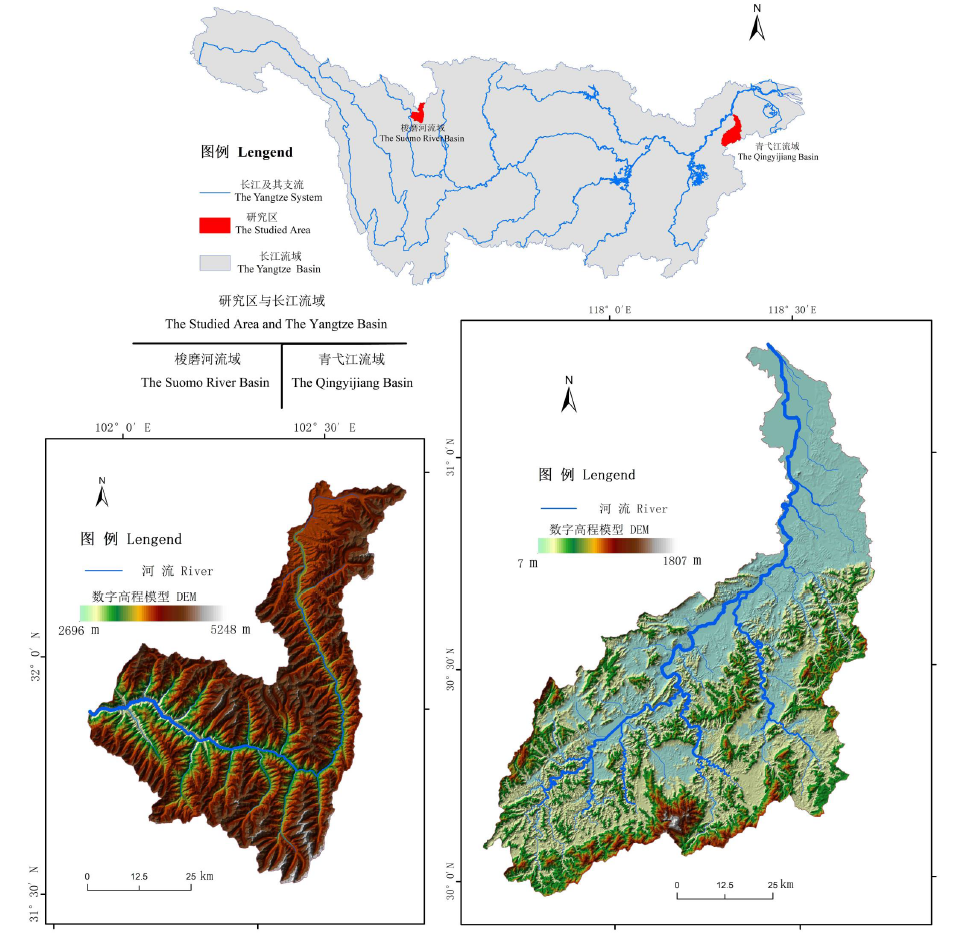
图1 梭磨河流域、青弋江流域和长江流域示意图
Fig. 1 Representation of the (left bottom) Suomo River basin, the (right bottom) Qingyijiang basin, and the (top) Yangtze Basin
| Treatment Test | Description | Precipitation type |
|---|---|---|
| T | Control test | Reanalysis precipitation |
| T+2 | Temperature increase by 2 ℃ for each step | Reanalysis precipitation |
| T+2, (1+20%) P Increase | in temperature of 2 ℃ and increase in precipitation by 20% for each step | Reanalysis precipitation |
| T+5, (1+40%) P Increase | in temperature by 5 ℃ and increase in precipitation by 40% for each step | Reanalysis precipitation |
| PT | Control test | Measured precipitation |
| PT-1 | Temperature decrease by 1 ℃ for each step | Measured precipitation |
| PT+2 | Temperature increase by 2 ℃ for each step | Measured precipitation |
| PT+2, (1+33%) P Increase | in temperature of 2 ℃ and increase in precipitation by 33% for each step | Measured precipitation |
| PT+4, (1+33%) P Increase | in temperature of 4.0 ℃ and increase in precipitation by 33% for each step | Measured precipitation |
| PT+6 | Temperature increase by 6.0 ℃ for each step | Measured precipitation |
| PT+6, (1+33%)P | Temperature increase by 6.0 ℃ and increase in precipitation by 33% for each step | Measured precipitation |
表1 试验说明
Table 1 Test descriptions
| Treatment Test | Description | Precipitation type |
|---|---|---|
| T | Control test | Reanalysis precipitation |
| T+2 | Temperature increase by 2 ℃ for each step | Reanalysis precipitation |
| T+2, (1+20%) P Increase | in temperature of 2 ℃ and increase in precipitation by 20% for each step | Reanalysis precipitation |
| T+5, (1+40%) P Increase | in temperature by 5 ℃ and increase in precipitation by 40% for each step | Reanalysis precipitation |
| PT | Control test | Measured precipitation |
| PT-1 | Temperature decrease by 1 ℃ for each step | Measured precipitation |
| PT+2 | Temperature increase by 2 ℃ for each step | Measured precipitation |
| PT+2, (1+33%) P Increase | in temperature of 2 ℃ and increase in precipitation by 33% for each step | Measured precipitation |
| PT+4, (1+33%) P Increase | in temperature of 4.0 ℃ and increase in precipitation by 33% for each step | Measured precipitation |
| PT+6 | Temperature increase by 6.0 ℃ for each step | Measured precipitation |
| PT+6, (1+33%)P | Temperature increase by 6.0 ℃ and increase in precipitation by 33% for each step | Measured precipitation |

图2 青弋江流域植被覆盖率随时间的演变(a)和梭磨河流域控制试验植被覆盖率随时间的演变(b)
Fig. 2 Temporal evolution of vegetation fractional cover in the simulation for the Qingyijiang basin (a) and temporal evolution of vegetation fractional cover in the control run for the Suomo River basin (b)

图3 青弋江流域年蒸散及其分量随时间的演变(a)和梭磨河流域控制试验年蒸散及其分量随时间的演变(b)
Fig. 3 Temporal evolution of annual evapotranspiration and its three components in the simulation for the Qingyijiang basin (a) and temporal evolution of annual evapotranspiration and its three components in the control run for the Suomo River basin (b)

图4 青弋江流域年径流深随时间的演变(a)和梭磨河流域控制试验年径流深随时间的演变(b)
Fig. 4 Temporal evolution of annual runoff depth in the simulation for the Qingyijiang basin (a) and temporal evolution of annual runoff depth in the control run for the Suomo River basin (b)
| Treatments | Smulation year | The 6‒ 10th year | The 21‒ 25th year | The 596‒ 600th year |
|---|---|---|---|---|
| PT+6 | Edc/(mm∙a-1) | 159.6 | 210.9 | 266.5 |
| Ewc/(mm∙a-1) | 202.6 | 232.6 | 369.2 | |
| Egs/(mm∙a-1) | 283.5 | 263.6 | 105.4 | |
| PT+6, (1+33%) P | Edc/(mm∙a-1) | 160.2 | 220.3 | 299.1 |
| Ewc/(mm∙a-1) | 216.7 | 248.3 | 429.5 | |
| Egs/(mm∙a-1) | 300.7 | 298.8 | 148.3 |
表2 3个时段平均蒸腾(Edc),冠层截留蒸发(Ewc)和土壤蒸发(Egs)
Table 2 Mean annual transpiration (Edc), canopy interception evaporation (Ewc) and soil evaporation (Egs) for the three periods
| Treatments | Smulation year | The 6‒ 10th year | The 21‒ 25th year | The 596‒ 600th year |
|---|---|---|---|---|
| PT+6 | Edc/(mm∙a-1) | 159.6 | 210.9 | 266.5 |
| Ewc/(mm∙a-1) | 202.6 | 232.6 | 369.2 | |
| Egs/(mm∙a-1) | 283.5 | 263.6 | 105.4 | |
| PT+6, (1+33%) P | Edc/(mm∙a-1) | 160.2 | 220.3 | 299.1 |
| Ewc/(mm∙a-1) | 216.7 | 248.3 | 429.5 | |
| Egs/(mm∙a-1) | 300.7 | 298.8 | 148.3 |
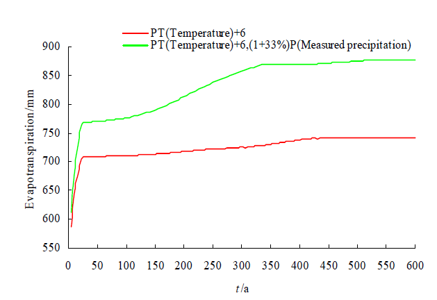
图5 PT+6和PT+6,(1+33%) P试验模拟的年蒸散随时间的演变
Fig. 5 Temporal evolution of annual evapotranspiration produced by PT+6 and PT+6, (1+33%) P runs
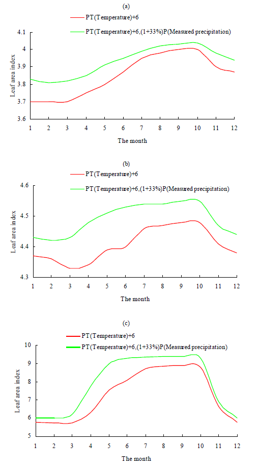
图6 第6—10个模拟年平均各月叶面积指数(a),第21—25个模拟年平均各月叶面积指数(b)和最后5个模拟年平均各月森林叶面积指数(c)
Fig. 6 Mean monthly leaf area index averaged over the 6th?10th simulation years (a), mean monthly leaf area index averaged over the 21st?25th simulation years (b) and mean monthly leaf area index averaged over the last five simulation years (c)
| [1] |
BOSCH J M, HEWLETT J D, 1982. A review of catchment experiments to determine the effect of vegetation changes on water yield and evapotranspiration[J]. Journal of Hydrology, 55(1-4): 3-23.
DOI URL |
| [2] |
COWLING S A, JONES C D, COX P M, 2009. Greening the terrestrial biosphere: Simulated feedbacks on atmospheric heat and energy circulation[J]. Climate Dynamics, 32(2-3): 287-299.
DOI URL |
| [3] |
COX P M, BETTS R A, JONES C D, et al., 2000. Acceleration of global warming due to carbon-cycle feedbacks in a coupled climate model[J]. Nature, 408(6809): 184-187.
DOI URL |
| [4] | COX P M, BETTS R A, JONES C D, et al., 2001. Modelling vegetation and the carbon cycle as interactive elements of the climate system[C]// Pearce R, Meteorology at the Millennium. New York: Academic Press: 259-279. |
| [5] |
DAN L, JI J J, XIE Z H, et al., 2012. Hydrological projections of climate change scenarios over the 3H region of China: A VIC model assessment[J]. Journal of Geophysical Research, DOI: 10.1029/2011JD017131.
DOI |
| [6] |
DENG H P, SUN S F, 2012. Incorporation of TOPMODEL into land surface model SSiB and numerically testing the effects of the corporation at basin scale[J]. Science China Earth Sciences, 55(10): 1731-1741.
DOI URL |
| [7] |
DUNN S M, MACKAY R, 1995. Spatial variation in evapotranspiration and the influence of land use on catchment hydrology[J]. Journal of Hydrology, 171(1-2): 49-73.
DOI URL |
| [8] |
GERTEN D, SIBYLL S, UWE H, et al., 2004. Terrestrial vegetation and water balance-hydrological evaluation of a dynamic global vegetation model[J]. Journal of Hydrology, 286: 249-270.
DOI URL |
| [9] |
LIU Y, XUE Y K, MACDONALD G, et al., 2019. Global vegetation variability and its response to elevated CO2, global warming, and climate variability - a study using the offline SSiB4/TRIFFID model and satellite data[J]. Earth System Dynamics, 10: 9-29.
DOI URL |
| [10] |
PENG J, DAN L, 2015. Impacts of CO2 concentration and climate change on the terrestrial carbon flux using six global climate-carbon coupled models[J]. Ecological Modelling, 304: 69-83.
DOI URL |
| [11] |
SELLERS P J, RANDALL D A, COLLATZ G J, et al., 1996. A revised land surface parameterization (SiB2) for atmospheric GCMs[J]. Journal of Climate, 9(4): 676-705.
DOI URL |
| [12] |
XUE Y K, SELLERS P J, KINTER J L, et al., 1991. A simplified biosphere model for global climate studies[J]. Journal of Climate, 4(3): 345-364.
DOI URL |
| [13] | XUE Y K, DENG H P, COX P M, 2006. Testing a coupled biophysical/ dynamic vegetation model (SSiB-4/TRIFFID) in different climate zones using satellite-derived and ground-measured data, 86th AMS Annual Meeting, 18th Conference on Climate Variability and Change [EB/OL] (2006-01-31) [2018-09-04]. https://ams.confex.com/ams/Annual2006/webprogram/Paper101721.html. |
| [14] |
ZHAN X W, XUE Y K, COLLATZ G J, 2003. An analytical approach for estimating CO2 and heat fluxes over the Amazonian Region[J]. Ecological Modeling, 162(1-2): 97-117.
DOI URL |
| [15] |
ZHANG M F, LIU N, HARPER R, et al., 2017. A global review on hydrological responses to forest change across multiple spatial scales: Importance of scale, climate, forest type and hydrological regime[J]. Journal of Hydrology, 546: 44-59.
DOI URL |
| [16] |
ZHANG Z Q, XUE Y K, MACDONALD G, et al., 2015. Investigation of north American vegetation variability under recent climate: A study using the SSiB4/TRIFFID biophysical/dynamic vegetation model[J]. Journal of Geophysical Research: Atmospheres, 120(4): 1300-1321.
DOI URL |
| [17] | 邓慧平, 丹利, 王倩, 等, 2018. 气候变化对西南亚高山区流域碳水平衡的影响模拟[J]. 生态环境学报, 27(11): 2057-2064. |
| DENG H P, DAN L, WANG Q, et al., 2018. Simulations of the impacts of climate changes on carbon and water balances for a sub-alpine basin in the mountain region of southwestern China[J]. Ecology and Environmental Sciences, 27(11): 2057-2064. | |
| [18] | 邓慧平, 丹利, 王倩, 2019. 西南亚高山区流域植被演替与地表水量平衡对气候变化的敏感性模拟[J]. 水资源与水工程学报, 30(3): 1-8. |
| DENG H P, DAN L, WANG Q, 2018. Simulations of the sensitivities of vegetation succession and surface water balances to climate changes for a sub-alpine basin in the mountain region of Southwestern China[J]. Journal of Water Resources & Water Engineering, 30(3): 1-8. | |
| [19] | 邓慧平, 丹利, 王倩, 等, 2020. 气候与植被覆盖变化对西南亚高山区流域碳水循环的影响模拟[J]. 气候与环境研究, 25(1): 21-31. |
| DENG H P, DAN L, WANG Q, et al., 2020. Simulations of the impact of climate and vegetation cover changes on carbon and water cycles of a subalpine basin in the mountain region of southwestern China[J]. Climatic and Environmental Research, 25(1): 21-31. | |
| [20] | 高海风, 1986. 海南岛三大河流对森林砍伐的水文效应分析[J]. 热带地理, 6(3): 264-271. |
| GAO H F, 1986. Effects of deforestation on hydrological elements of the River on Hainan Island[J]. Tropical Geography, 6(3): 264-271. | |
| [21] | 黄秉维, 1982. 森林对环境作用的几个问题[J]. 中国水利 (1): 30-32. |
| HUANG B W, 1982. Several issues on the effect of forest on environment [J]. China Water Resources (1): 30-32. | |
| [22] | 金栋梁, 刘予伟, 2007. 森林的水文效应实验分析[J]. 水资源研究, 28(3): 12-17. |
| JIN D L, LIU Y W, J. 2007. Experimental analysis on the hydrological effect of forest [J]. Water Resources Research, 28(3): 12-17. | |
| [23] | 李昌哲, 郭卫东, 1986. 森林植被的水文效应[J]. 生态学杂志, 5(5): 17-21. |
| GUO W D, 1986. Hydrologic effects of forest vegetation[J]. Journal o f Ecology, 5(5): 17-21. | |
| [24] | 李文华, 何永涛, 杨丽韫, 2001. 森林对径流影响研究的回顾与展望[J]. 自然资源学报, 16(5): 398-406. |
| LI W H, HE Y T, YANG L Y, 2001. A Summary and perspective of forest vegetation impacts on water yield[J]. Journal of Natural Resources, 16(5): 398-406. | |
| [25] | 李玉山, 2001. 黄土高原森林植被对陆地水循环影响的研究[J]. 自然资源学报, 16(5): 427-432. |
| LI Y S, 2001. Effects of forest on water circle on the Loess Plateau [J]. Journal of Natural Resources, 16(5): 427-432. | |
| [26] |
刘昌明, 钟骏襄, 1978. 黄土高原森林对年径流影响的初步分析[J]. 地理学报, 33(2): 112-127.
DOI |
| LIU C M, CHUNG C H, 1978. The influence of forest cover upon annual runoff in the Loess Plateau of China[J]. Acta Geographica Sinica, 33(2): 112-127. | |
| [27] | 刘惠民, 邓慧平, 孙菽芬, 等, 2013. 陆面模式SSiB耦合TOPMODEL对流域水文模拟影响的数值试验[J]. 高原气象, 32(3): 829-838. |
| LIU H M, DENG H P, SUN S F, 2013. Numerically test of influence of incorporation of TOPMODEL into land surface model SSiB on hydrological simulation at basin scale[J]. Plateau Meteorology, 32(3): 829-838. | |
| [28] |
刘世荣, 孙鹏森, 温远光, 2003. 中国主要森林生态系统水文功能的比较研究[J]. 植物生态学报, 27(1): 16-22.
DOI |
| LIU S R, SUN P S, WEN Y G, 2003. Comparative analysis of hydrological functions of major forest ecosystems in China[J]. Acta Phytoecologica Sinica, 27(1): 16-22. | |
| [29] | 马雪华, 1987. 四川米亚罗地区高山冷杉林水文作用的研究[J]. 林业科学, 23(3): 253-264. |
| MA X H, 1987. Preliminary study on hydrological function of fir forest in Miyaluo region of Sichuan[J]. Scientia Silves Sinicae, 23(3): 253-264. | |
| [30] | 王金叶, 车克钧, 1998. 祁连山森林复合流域径流规律研究[J]. 土壤侵蚀与水土保持学报, 4(1): 22-27. |
| WANG J Y, CHE K J, 1998. Runoff-produced laws of complex forest watershed in Qilian Mountain[J]. Journal of Soil Erosion and Soil and Water Conservation, 4(1): 22-27. | |
| [31] | 杨海军, 孙立达, 余新晓, 1994. 晋西黄土区森林流域水量平衡研究[J]. 水土保持通报, 14(2): 26-31. |
| YANG H J, SUN L D, YU X X, 1994. Study of the water balance for soil and water conservation in forests west-north Shanxi province[J]. Bulletin of Soil and Water Conservation, 14(2): 26-31. | |
| [32] | 张发会, 陈林武, 吴雪仙, 等, 2007. 长江上游低山丘陵区小流域森林植被变化对径流影响分析[J]. 四川林业科技, 28(4): 49-53. |
| ZHANG F H, CHEN L W, WU X X, et al., 2007. An analysis of influences of forest vegetation changes on the runoff in small watersheds in hilly areas in the upper reaches of the Yangtze River[J]. Journal of Sichuan Forestry Science and Technology, 28(4): 49-53. | |
| [33] | 张晓明, 余新晓, 武思宏, 等, 2006. 黄土区森林植被对流域径流和输沙的影响[J]. 中国水土保持科学, 4(3): 48-53. |
| ZHANG X M, YU X X, WU S H, et al., 2006. Influence of forest vegetation on runoff and sediment transport of watershed in loess area [J]. Science of Soil and Water Conservation, 4(3): 48-53. | |
| [34] | 周晓峰, 赵惠勋, 孙慧珍, 2001. 正确评价森林水文效应[J]. 自然资源学报, 16(5): 420-426. |
| ZHOU X F, ZHAO H X, SUN H Z, Proper assessment for forest hydrological effects [J]. Journal of Natural Resources, 16(5): 420-426. | |
| [35] | 朱丽, 秦富仓, 姚云峰, 等, 2010. 北京市红门川流域森林植被/土地覆被变化的水文响应[J]. 生态学报, 30(16): 4287-4294. |
| ZHU L, QIN F C, YAO Y F, et al., 2010. Response of forest vegetation/land use change to hydrological dynamics in Hongmenchuan watershed of Beijing[J]. Acta Ecologica Sinica, 30(16): 4287-4294. |
| [1] | 王雪梅, 杨雪峰, 赵枫, 安柏耸, 黄晓宇. 基于机器学习算法的干旱区绿洲地上生物量估算[J]. 生态环境学报, 2023, 32(6): 1007-1015. |
| [2] | 陈科屹, 林田苗, 王建军, 何友均, 张立文. 天保工程20年对黑龙江大兴安岭国有林区森林碳库的影响[J]. 生态环境学报, 2023, 32(6): 1016-1025. |
| [3] | 张兴旺, 谢艳萍, 吴晓敏, 李垚, 肖书平. 福建省明溪县极小种群野生植物喜树种群结构与动态特征[J]. 生态环境学报, 2023, 32(6): 1037-1044. |
| [4] | 杜彩艳, 杨鹏, 蜂述先, 毛妍婷, 陶琼, 此主拉姆, 彭慧娉, 和建美, 李卫林. 不同生态区维西糯山药品质与生态因子相关性研究[J]. 生态环境学报, 2023, 32(6): 1053-1061. |
| [5] | 翁升恒, 张玉琴, 姜冬昕, 潘卫华, 李丽纯, 张方敏. 福建省森林植被NEP时空变化及影响因子分析[J]. 生态环境学报, 2023, 32(5): 845-856. |
| [6] | 巫晨煜, 许帆帆, 魏士博, 樊晶晶, 刘观鹏, 王坤. 渭河流域地表植被覆盖对气候变化的响应研究[J]. 生态环境学报, 2023, 32(5): 835-844. |
| [7] | 郝蕾, 翟涌光, 戚文超, 兰穹穹. 2001-2020年内蒙古植被碳源/碳汇时空动态及对气候因子的响应[J]. 生态环境学报, 2023, 32(5): 825-834. |
| [8] | 李阳, 侯志勇, 陈薇, 于晓英, 谢永宏, 黄鑫, 谭佩阳, 李继承, 黎尚林, 杨辉. 大围山高山湿地植物多样性与区系组成研究[J]. 生态环境学报, 2023, 32(4): 643-650. |
| [9] | 胡芳, 刘聚涛, 温春云, 韩柳, 文慧. 抚河流域浮游植物群落结构特征及其水生态状况评价[J]. 生态环境学报, 2023, 32(4): 744-755. |
| [10] | 李善家, 王兴敏, 刘海锋, 孙梦格, 雷雨昕. 河西走廊荒漠植物多样性及其对环境因子的响应[J]. 生态环境学报, 2023, 32(3): 429-438. |
| [11] | 李晖, 李必龙, 葛黎黎, 韩琛惠, 杨倩, 张岳军. 2000-2021年汾河流域植被时空演变特征及地形效应[J]. 生态环境学报, 2023, 32(3): 439-449. |
| [12] | 徐晨, 裴顺祥, 吴莎, 郭慧, 马淑敏, 吴迪, 章尧想, 法蕾. 北京九龙山不同林型林间大气主要BVOCs组成研究[J]. 生态环境学报, 2023, 32(2): 245-255. |
| [13] | 张鐥文, 杨冉, 侯文星, 王丽丽, 刘爽, 宋汉扬, 赵文吉, 李令军. 生态补水前后永定河两岸植被覆盖度变化及驱动力分析[J]. 生态环境学报, 2023, 32(2): 264-273. |
| [14] | 宋志斌, 周佳诚, 谭路, 唐涛. 高原河流着生藻类群落沿海拔梯度的变化特征--以西藏黑曲、雪曲为例[J]. 生态环境学报, 2023, 32(2): 274-282. |
| [15] | 贾志峰, 刘鹏程, 刘宇, 吴博博, 陈丹姿, 张向飞. 气候变化和人类活动对松辽流域植被覆盖的影响[J]. 生态环境学报, 2023, 32(1): 1-10. |
| 阅读次数 | ||||||
|
全文 |
|
|||||
|
摘要 |
|
|||||