生态环境学报 ›› 2023, Vol. 32 ›› Issue (5): 835-844.DOI: 10.16258/j.cnki.1674-5906.2023.05.002
巫晨煜1,2( ), 许帆帆1,2, 魏士博1,2, 樊晶晶1,2,3,*(), 刘观鹏1,2, 王坤3
收稿日期:2022-11-24
出版日期:2023-05-18
发布日期:2023-08-09
通讯作者:
*樊晶晶(1986年生),副教授,博士,研究方向为水文学及水资源。E-mail: fanjingjing@hebeu.edu.cn作者简介:巫晨煜(1998年生),女,硕士研究生,研究方向为水文学及水资源。E-mail: wwwuchenyu@163.com
基金资助:
WU Chenyu1,2(), XU Fanfan1,2, WEI Shibo1,2, FAN Jingjing1,2,3,*(), LIU Guanpeng1,2, WANG Kun3
Received:2022-11-24
Online:2023-05-18
Published:2023-08-09
摘要:
气候变化通过改变植物生长环境,从而影响植物生长。了解植物与气候之间的内在关系,长期动态监测和评估植被覆盖情况至关重要,同时有利于深刻理解生态恢复机制。渭河流域地理位置特殊,生态环境脆弱,在其周围及黄河下游生态环境保护中有重要地位。为揭示植被时空变化格局以及对气候变化的响应,以渭河流域作为研究对象,采用差值法、线性回归斜率法及相关系数法分析2000-2019年渭河流域在不同气候分区下NDVI分布特征及NDVI与降水、气温的相关性和滞后性。研究结果显示:(1)2000-2019年,渭河流域NDVI呈波动上升的趋势,各分区NDVI增长率表现为半干旱区 (0.0538/10a)>半湿润区 (0.0443/10a)>干旱区 (0.0366/10a);(2)2000-2009年、2009-2019年NDVI均表现为改善态势,但2009-2019年改善程度减缓,斜率从0.0727/10a降低为0.0351/10a,差值法改善区面积由98.20%降低到86.12%,线性回归斜率法改善区面积由87.69%减小到61.86%;(3)在季尺度、月尺度上,与降水相比,气温对渭河流域植被生长影响更为显著;(4)渭河流域及其各分区(除干旱区短期气温对NDVI的滞后效应)NDVI与降水、气温双向滞后效应在短期(1-3月)与长期(3-6月)同时存在。在不同气候分区下,NDVI与降水双向滞后效应表现出1-3月为正,3-6月为负的特征;NDVI对气温的滞后效应表现为1-3月为正,4-6月为负;气温对NDVI的滞后效应1-2月为正,3-4月为负。
中图分类号:
巫晨煜, 许帆帆, 魏士博, 樊晶晶, 刘观鹏, 王坤. 渭河流域地表植被覆盖对气候变化的响应研究[J]. 生态环境学报, 2023, 32(5): 835-844.
WU Chenyu, XU Fanfan, WEI Shibo, FAN Jingjing, LIU Guanpeng, WANG Kun. Study on Response of Surface Vegetation Cover to Climate Change in Weihe River Basin[J]. Ecology and Environment, 2023, 32(5): 835-844.
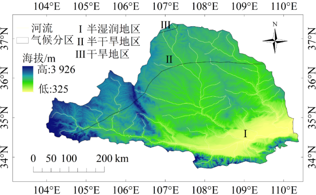
图1 渭河流域分区图
Figure 1 Division of Wei River Basin

图2 2000-2019年渭河流域及其分区NDVI线性变化趋势
Figure 2 Linear trend of NDVI in the Wei River Basin and its subregions from 2000 to 2019
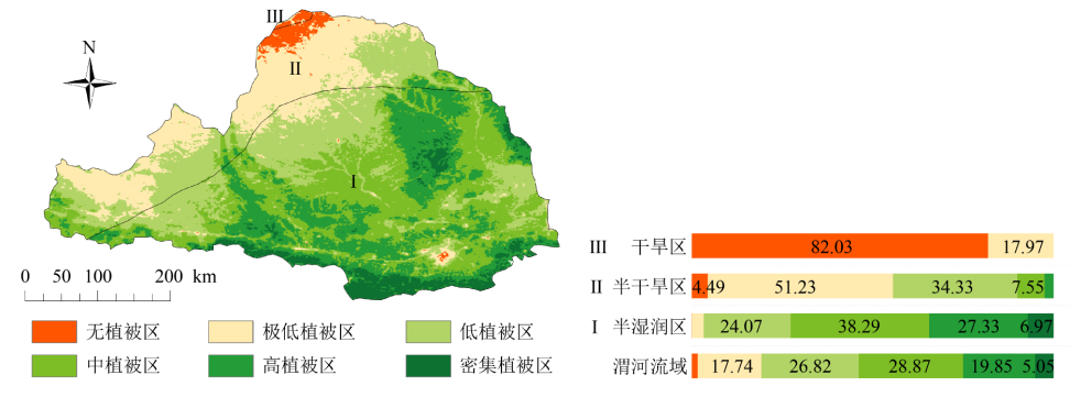
图3 2000-2019年渭河流域NDVI均值空间分布及植被情况面积百分比(%)
Figure 3 Percentage of vegetation cover area and spatial distribution of NDVI mean values in each subzone of the Wei River basin from 2000 to 2019
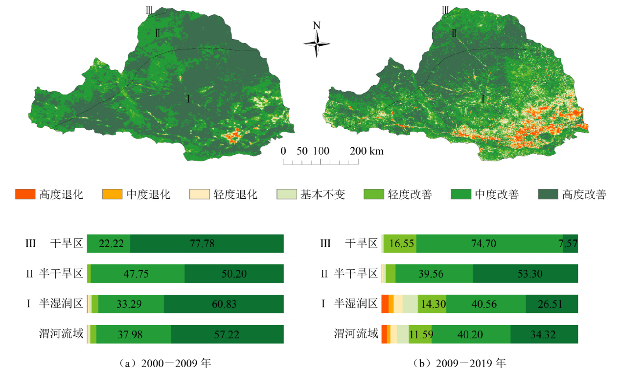
图4 渭河流域2000-2009年(a)、2009-2019年(b)NDVI差值空间分布及植被变化情况面积所占百分比(%)
Figure 4 NDVI difference spatial distribution and Percentage of vegetation change area in Wei River Basin from 2000 to 2009 (a) and from 2009 to 2019 (b)

图5 渭河流域2000-2009年(a)、2009-2019年(b)NDVI线性回归斜率空间分布及植被动态变化面积所占百分比(%)
Figure 5 Spatial distribution of NDVI linear regression slope in Wei River Basin and Percentage of vegetation dynamic change area from 2000 to 2009 (a) and from 2009 to 2019 (b)

图6 渭河流域2000-2009年(a)、2009-2019年(b)NDVI变化趋势显著性
Figure 6 Significance of NDVI change trend in Wei River basin from 2000 to 2009 and from 2009 to 2019
| 分区 | 年尺度 | 季尺度 | 月尺度 | |||||
|---|---|---|---|---|---|---|---|---|
| P | T | P | T | P | T | |||
| 渭河流域 | 0.437 | 0.0858 | 0.503** | 0.669** | 0.415** | 0.761** | ||
| 干旱区 | 0.608** | -0.0869 | 0.572** | 0.00208 | 0.564** | 0.215** | ||
| 半干旱区 | 0.548* | 0.0376 | 0.609** | 0.198 | 0.507** | 0.527** | ||
| 半湿润区 | 0.374 | 0.0831 | 0.436** | 0.775** | 0.350** | 0.804** | ||
表1 2000-2019年渭河流域NDVI与降水、气温偏相关系数
Table 1 Partial correlation coefficient between NDVI and precipitation and temperature at different scales in the Wei River basin, 2000-2019
| 分区 | 年尺度 | 季尺度 | 月尺度 | |||||
|---|---|---|---|---|---|---|---|---|
| P | T | P | T | P | T | |||
| 渭河流域 | 0.437 | 0.0858 | 0.503** | 0.669** | 0.415** | 0.761** | ||
| 干旱区 | 0.608** | -0.0869 | 0.572** | 0.00208 | 0.564** | 0.215** | ||
| 半干旱区 | 0.548* | 0.0376 | 0.609** | 0.198 | 0.507** | 0.527** | ||
| 半湿润区 | 0.374 | 0.0831 | 0.436** | 0.775** | 0.350** | 0.804** | ||
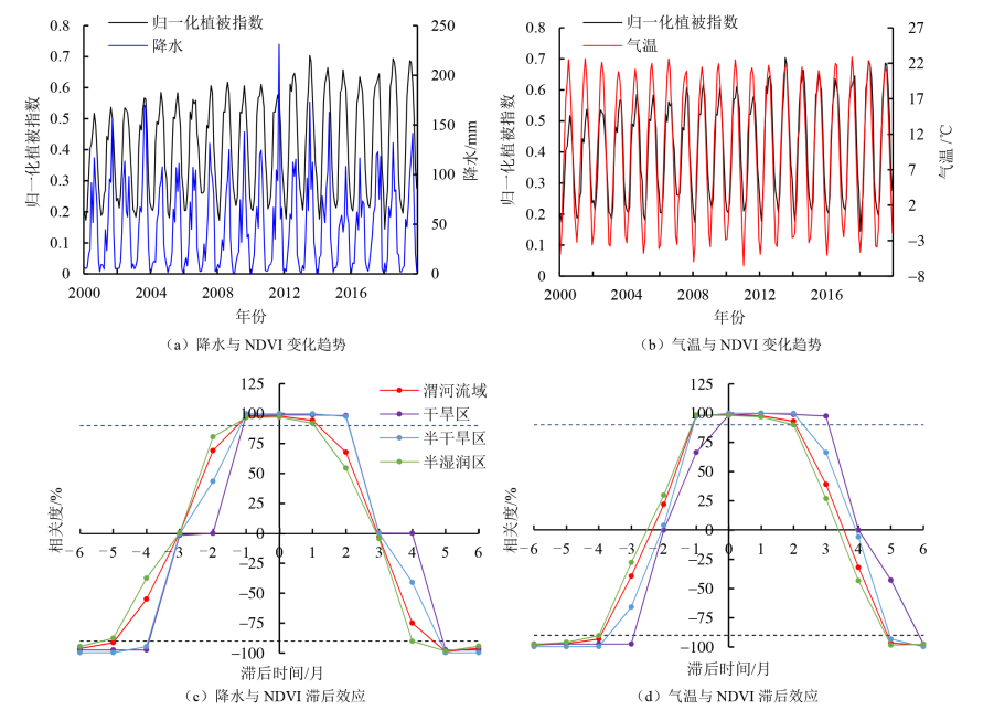
图7 NDVI与降水、气温变化规律及滞后效应
Figure 7 NDVI and precipitation, temperature change rule and lag effect
| [1] | DING Y X, LI Z, PENG S Z, 2020. Global analysis of time-lag and-accumulation effects of climate on vegetation growth[J]. International Journal of Applied Earth Observation and Geoinformation, 92: 102179. |
| [2] |
JIA L, LI Z B, XU G C, et al., 2020. Dynamic change of vegetation and its response to climate and topographic factors in the Xijiang River Basin, China[J]. Environmental Science and Pollution Research, 27(11): 11637-11648.
DOI |
| [3] | JOBBAGY E G, SALA O E, PARUELO J M, 2002. Patterns and controls of primary production in the Patagonian steppe: A remote sensing approach[J]. Ecology, 83(2): 307-319. |
| [4] | LI P, WANG J, LIU M M, et al., 2021. Spatio-temporal variation characteristics of NDVI and its response to climate on the Loess Plateau from 1985 to 2015[J]. Catena, 203: 105331. |
| [5] |
NIU J, CHEN J, SUN L Q, et al., 2018. Time-lag effects of vegetation responses to soil moisture evolution: a case study in the Xijiang Basin in South China[J]. Stochastic Environmental Research and Risk Assessment, 32(8): 2423-2432.
DOI |
| [6] |
WANG H J, LI Z, CAO L, et al., 2021. Response of NDVI of natural vegetation to climate changes and drought in China[J]. Land, 10(9): 966.
DOI URL |
| [7] | XIN Z B, XU J X, ZHENG W, 2008. Spatiotemporal variations of vegetation cover on the Chinese Loess Plateau (1981-2006): Impacts of climate changes and human activities[J]. Science in China Series D: Earth Sciences, 51(1): 67-78. |
| [8] | 陈晨, 王义民, 黎云云, 等, 2022. 黄河流域1982-2015年不同气候区植被时空变化特征及其影响因素[J]. 长江科学院院报, 39(2): 56-62, 81. |
| CHEN C, WANG Y M, LI Y Y, et al., 2022. Vegetation changes and influencing factors in different climatic regions of Yellow River Basin from 1982 to 2015[J]. Journal of Yangtze River Scientific Research Institute, 39(2): 56-62, 81. | |
| [9] |
陈文裕, 夏丽华, 徐国良, 等, 2022. 2000-2020年珠江流域NDVI动态变化及影响因素研究[J]. 生态环境学报, 31(7): 1306-1316.
DOI |
| CHEN W Y, XIA L H, XU G L, et al., 2022. Dynamic variation of NDVI and its influencing factors in the Pearl River Basin from 2000 to 2020[J]. Ecology and Environmental Sciences, 31(7): 1306-1316. | |
| [10] | 程杰, 杨亮彦, 黎雅楠, 2020. 2000-2018年陕北地区NDVI时空变化及其对水热条件的响应[J]. 灌溉排水学报, 39(5): 111-119. |
| CHENG J, YANG L Y, LI Y N, 2020. Spatiotemporal variation in NDVI and its response to hydrothermal change from 2000 to 2018 in northern Shaanxi province[J]. Journal of Irrigation and Drainage, 39(5): 111-119. | |
| [11] | 程三友, 王红梅, 李英杰, 2011. 渭河水系流域地貌特征及其成因分析[J]. 地理与地理信息科学, 27(3): 45-49. |
| CHENG S Y, WANG H M, LI Y J, 2011. Geomorphology characteristics of the Wei River Basin and its formation reasons[J]. Geography and Geo-Information Science, 27(3): 45-49. | |
| [12] | 崔利芳, 王伦澈, 屈赛, 等, 2020. 气温、降水量和人类活动对长江流域植被NDVI的影响[J]. 地球科学, 45(6): 1905-1917. |
| CUI L F, WANG L C, QU S, et al., 2020. Impacts of temperature, precipitation and human activity on vegetation NDVI in Yangtze River Basin, China[J]. Earth Science, 45(6): 1905-1917. | |
| [13] | 崔林丽, 史军, 杨引明, 等, 2009. 中国东部植被NDVI对气温和降水的旬响应特征[J]. 地理学报, 64(7): 850-860. |
|
CUI L L, SHI J, YANG Y M, et al., 2009. Ten-day Response of vegetation NDVI to the Variations of Temperature and Precipitation in Eastern China[J]. Acta Geographica Sinica, 64(7): 850-860.
DOI |
|
| [14] | 杜希溪, 2013. 渭河流域气候舒适度变化特征及其对植被覆盖响应研究[D]. 杨凌: 西北农林科技大学: 1-63. |
| DU X X, 2013. Climate comfortable index changes and its response to ecological environment in the Weihe River Basin[D]. Yangling: China: Northwest A&F University: 1-63. | |
| [15] | 范松克, 郝成元, 2019. 2001-2016年河南省NDVI时空变化特征分析[J]. 江苏农业学报, 35(4): 860-867. |
| FAN S K, HAO C Y, 2019. Temporal and spatial variation analysis of NDVI in Henan from 2001 to 2016[J]. Jiangsu Journal of Agricultural Sciences, 35(4): 860-867. | |
| [16] | 高培霞, 张吴平, 梁爽, 等, 2018. 基于温度植被干旱指数 (TVDI) 的土壤干湿反演[J]. 灌溉排水学报, 37(10): 123-128. |
| GAO P X, ZHANG W P, LIANG S, et al., 2018. Retrievably calculating soil moisture based on temperature vegetation drought index of vegetative land[J]. Journal of Irrigation and Drainage, 37(10): 123-128. | |
| [17] | 黄豪奔, 徐海量, 林涛, 等, 2022. 2001-2020年新疆阿勒泰地区归一化植被指数时空变化特征及其对气候变化的响应[J]. 生态学报, 42(7): 2798-2809. |
| HUANG H B, XU H L, LIN T, et al., 2020. Spatio-temporal variation characteristics of NDVI and its response to climate change in the Altay region of Xinjiang from 2001 to 2020[J]. Acta Ecologica Sinica, 42(7): 2798-2809. | |
| [18] | 李春娥, 马静, 何芷, 等, 2022. 伊犁河谷天然植被覆盖度的变化特征分析[J]. 地理空间信息, 20(2): 84-88. |
| LI C E, MA J, HE Z, et al., 2022. Change characteristic analysis of natural vegetation coverage in Yili River Valley[J]. Geospatial Information, 20(2): 84-88. | |
| [19] | 李丹利, 苟思, 赵娜娜, 等, 2018. 基于MODIS-NDVI与EVI数据的若尔盖区域植被生育期分析[J]. 灌溉排水学报, 37(S1): 162-166, 174. |
| LI D L, GOU S, ZHAO N N, et al., 2018. Analysis of vegetation growth period in Zoigê based on MODIS-NDVI and EVI[J]. Journal of Irrigation and Drainage, 37(S1): 162-166, 174. | |
| [20] | 李思楠, 赵筱青, 谭琨, 等, 2021. 孟加拉国博多河流域NDVI时空变化及其与气候因子的相关性[J]. 水土保持研究, 28(1): 139-146. |
| LI S N, ZHAO X Q, TAN K, et al., 2021. Spatiotemporal variation of NDVI and its relationship with climate in Padma River Basin of Bangladesh[J]. Research of Soil and Water Conservation, 28(1): 139-146. | |
| [21] |
李霞, 李晓兵, 陈云浩, 等, 2007. 中国北方草原植被对气象因子的时滞响应[J]. 植物生态学报, 31(6): 1054-1062.
DOI |
|
LI X, LI X B, CHEN Y H, et al., 2007. Temporal responses of vegetation to climate veriables in temperate steppe of northern China[J]. Chinese Journal of Plant Ecology, 31(6): 1054-1062.
DOI URL |
|
| [22] | 刘旻霞, 赵瑞东, 邵鹏, 等, 2018. 近15 a黄土高原植被覆盖时空变化及驱动力分析[J]. 干旱区地理, 41(1): 99-108. |
| LIU M X, ZHAO R D, SHAO P, et al., 2018. Temporal and spatial variation of vegetation coverage and its driving forces in the Loess Plateau from 2001 to 2015[J]. Arid Land Geography, 41(1): 99-108. | |
| [23] | 栾金凯, 刘登峰, 黄强, 等, 2018. 近17年陕西榆林植被指数的时空变化及影响因素[J]. 生态学报, 38(8): 2780-2790. |
| LUAN J K, LIU D F, HUANG Q, et al., 2018. Analysis of the spatial-temporal change and impact factors of the vegetation index in Yulin, Shaanxi Province, in the last 17 years[J]. Acta Ecologica Sinica, 38(8): 2780-2790. | |
| [24] | 陆一帆, 2016. 近30年来渭河流域植被与气候变化互影响模式的探寻分析[J]. 北京测绘 (5): 7-12. |
| LU Y F, 2016. The analysis of Weihe River Basin in vegetation and climate change of lnteraction model for nearly 30 years[J]. Beijing Surveying and Mapping (5): 7-12. | |
| [25] | 潘颖, 林杰, 佟光臣, 等, 2018. 2004-2014年太湖流域植被覆盖时空变化特征[J]. 生态与农村环境学报, 34(1): 37-45. |
| PAN Y, LIN J, TONG G C, et al., 2018. Spatio-temporal variations of vegetation coverage in Taihu Lake Basin from 2004 to 2014[J]. Journal of Ecology and Rural Environment, 34(1): 37-45. | |
| [26] | 庞家泰, 段金亮, 张瑞, 等, 2021. 2000-2019年渭河流域植被覆盖度时空演变特征及气候响应[J]. 水土保持研究, 28(5): 230-237. |
| PANG J T, DUAN J L, ZHANG R, et al., 2021. Characteristics of spatiotemporal evolution and climate response vegetation cover in the Wei River Basin from 2000 to 2019[J]. Research of Soil and Water Conservation, 28(5): 230-237. | |
| [27] |
邵亚婷, 王卷乐, 严欣荣, 2021. 蒙古国植被物候特征及其对地理要素的响应[J]. 地理研究, 40(11): 3029-3045.
DOI |
|
SHAO Y T, WANG J L, YAN X R, 2021. The phenological characteristics of Mongolian vegetation and its response to geographical elements[J]. Geographical Research, 40(11): 3029-3045.
DOI |
|
| [28] | 王丽霞, 张珈玮, 孟妮娜, 等, 2020. 基于CA-Markov的渭河流域NDVI时空变化模拟及预测[J]. 水土保持研究, 27(4): 206-212. |
| WANG L X, ZHANG J W, MENG N N, et al., 2020. Simulation and prediction of temporal and spatial changes of NDVI in Weihe River basin based on CA-Markov[J]. Research of Soil and Water Conservation, 27(4): 206-212. | |
| [29] | 王维, 鞠琴, 王乐扬, 等, 2021. 渭河上游流域径流对土地利用变化的时空响应[J]. 水力发电, 47(9): 41-45, 93. |
| WANG W, JU Q, WANG Y Y, et al., 2021. Spatiotemporal responses of runoff to land usage change in the upper reaches of Weihe River basin[J]. Water Power, 47(9): 41-45, 93. | |
| [30] | 王玉娟, 王树东, 曾红娟, 等, 2014. 基于作物缺水指数法的渭河流域干旱特征[J]. 干旱区研究, 31(1): 118-124. |
| WANG Y J, WANG S D, ZENG H J, et al., 2014. Drought characteristic in the Weihe River basin based on water shortage index of crops[J]. Arid Zone Research, 31(1): 118-124. | |
| [31] |
魏榕, 刘冀, 张特, 等, 2021. 雅砻江流域生长季植被时空变化特征及对气象因子的响应分析[J]. 生态环境学报, 30(3): 512-522.
DOI |
| WEI R, LI J, ZHANG T, et al., 2021. Analysis of vegetation spatiotemporal variation characteristics and response to meteorological factors in the growing Season in Yalong River basin[J]. Ecology and Environmental Sciences, 30(3): 512-522. | |
| [32] |
徐省超, 赵雪雁, 宋晓谕, 2021. 退耕还林(草)工程对渭河流域生态系统服务的影响[J]. 应用生态学报, 32(11): 3893-3904.
DOI |
| XU X C, ZHAO X Y, SONG X Y, 2021. Impacts of the returning farmland to forest (grassland) project on ecosystem services in the Weihe River Basin, China.[J]. Chinese Journal of Applied Ecology, 32(11): 3893-3904. | |
| [33] | 杨丽红, 张晓燕, 姚小萌, 2013. 延河流域NDVI时空变化及其对降水变化的响应研究[J]. 安徽农业科学, 41(22): 9381-9384. |
| YANG L H, ZHANG XY, YAO X M, et al., 2013. Changes of NDVI spatio-temporal in Yanhe River basin and its response to precipitation[J]. Journal of Anhui Agricultural Sciences, 41(22): 9381-9384. | |
| [34] | 易浪, 任志远, 张翀, 等, 2014. 黄土高原植被覆盖变化与气候和人类活动的关系[J]. 资源科学, 36(1): 166-174. |
| YI L, REN Z Y, ZHANG C, et al., 2014. Vegetation cover, climate and human activities on the Loess Plateau[J]. Resources Science, 36(1): 166-174. | |
| [35] | 袁倩颖, 马彩虹, 文琦, 等, 2021. 六盘山贫困区生长季植被覆盖变化及其对水热条件的响应[J]. 国土资源遥感, 33(2): 220-227. |
| YUAN Q Y, MA C H, WEN Q, et al., 2021. Vegetation cover change and its response to water and heat conditions in the growing season in Liupanshan poverty-stricken area[J]. Remote Sensing for Land and Resources, 33(2): 220-227. | |
| [36] | 袁瑞强, 青松, 2020. 2002-2015年黄河流域NDVI对陆地水储量的响应[J]. 灌溉排水学报, 39(10): 115-122. |
| YUAN R Q, QING S, 2020. Response of the normalized difference vegetation index to water storage in terrestrial basin of the Yellow River Basin: Taking 2002-2015 as an example[J]. Journal of Irrigation and Drainage, 39(10): 115-122. | |
| [37] |
杨鑫, 曹文侠, 鱼小军, 等, 2021. 基于近20年MODIS NDVI日数据的青海省草地资源动态监测及其对环境因子的响应[J]. 草业学报, 30(9): 1-14.
DOI |
|
YANG X, CAO W X, YU X J, et al., 2021. Dynamic monitoring of grassland resources and their responses to environmental factors in Qinghai province based on analyses of daily MODIS NDVI data from the past 20 years[J]. Acta Prataculturae Sinica, 30(9): 1-14.
DOI |
|
| [38] |
闫雪, 孟德坤, 陈迪桃, 等, 2020. 基于生态系统服务的中亚水土热资源匹配度时空变化特征[J]. 应用生态学报, 31(3): 794-806.
DOI |
|
YAN X, MENG D K, CHEN D T, et al., 2020. Spatio-temporal characteristics of the matching degree of water, soil, and heat resources based on ecosystem services in Central Asia[J]. Chinese Journal of Applied Ecology, 31(3): 794-806.
DOI |
|
| [39] |
余玉洋, 宋丰艺, 张世杰, 2022. 2000-2020年河南省NDVI时空变化及其驱动因素定量分析[J]. 生态环境学报, 31(10): 1939-1950.
DOI |
| YU Y Y, SONGF Y, ZHANG S J, 2022. Quantitative analysis of temporal and spatial changes of NDVI and its driving factors in Henan province from 2000 to 2020[J]. Ecology and Environmental Sciences, 31(10): 1939-1950. | |
| [40] |
尹振良, 冯起, 王凌阁, 等, 2022. 2000-2019年中国西北地区植被覆盖变化及其影响因子[J]. 中国沙漠, 42(4): 11-21.
DOI |
|
YIN Z L, FENG Q, WANG L G, et al., 2022. Vegetation coverage change and its influencing factors across the northwest region of China during 2000-2019[J]. Journal of Desert Research, 42(4): 11-21.
DOI |
|
| [41] | 赵孟丽, 李同昇, 李炬霖, 2023. 渭河流域人口与经济空间分布一致性及影响因素分析[J/OL]. 水土保持研究, 30(5): 1-10 [2023-05-04]. https://kns.cnki.net/kcms/detail//61.1272.P.20230116.1635.005.html. |
| ZHAO M L, LI T S, LI J L, 2023. Study on the consistency and influencing factors of population and economic spatial distribution in the Weihe River Basin[J/OL]. Research of Soil and Water Conservation, 30(5): 10 [2023-05-04]. https://kns.cnki.net/kcms/detail//61.1272.P.20230116.1635.005.html. | |
| [42] | 张戈丽, 徐兴良, 周才平, 等, 2011. 近30年来呼伦贝尔地区草地植被变化对气候变化的响应[J]. 地理学报, 66(1): 47-58. |
| ZHANG G L, XU X L, ZHOU C P, et al., 2011. Responses of vegetation changes to climatic variationsin Hulun Buir grassland in past 30 years[J]. Acta Geographica Sinica, 66(1): 47-58. | |
| [43] | 张晔, 侯精明, 龚佳辉, 等, 2022. 渭河中上游流域LUCC演变及径流的响应[J/OL]. 水土保持通报, 42(5): 1-8 [2023-05-04]. https://kns.cnki.net/kcms/detail/61.1094.X.20220922.1343.004.html. |
| ZHANG Y, HOU J M, GONG J H, et al., 2022. LUCC evolution and runoff response in middle and upper reaches of weihe river[J/OL]. Bulletin of Soil and Water Conservation, 42(5): 1-8 [2023-05-04]. https://kns.cnki.net/kcms/detail/61.1094.X.20220922.1343.004.html. | |
| [44] | 周梦甜, 李军, 朱康文, 2015. 近15 a新疆不同类型植被NDVI时空动态变化及对气候变化的响应[J]. 干旱区地理, 2015, 38(4): 779-787. |
| ZHOU M T, LI J, ZHU K W, 2015. Spatial-temporal dynamics of different types of vegetation NDVI and its response to climate change in Xinjiang during 1998-2012[J]. Arid Land Geogeaphy, 38(4): 779-787. | |
| [45] | 赵文智, 刘鹄, 2011. 干旱、半干旱环境降水脉动对生态系统的影响[J]. 应用生态学报, 22(1): 243-249. |
| ZHAO W Z, LIU H, 2011. Precipitation pulses and ecosystem responses in arid and semi-arid regions: A review[J]. Chinese Journal of Applied Ecology, 22(1): 243-249. |
| [1] | 董洁芳, 邓椿, 张仲伍. 渭河流域PM2.5时空演化及人口暴露风险[J]. 生态环境学报, 2023, 32(6): 1078-1088. |
| [2] | 李晖, 李必龙, 葛黎黎, 韩琛惠, 杨倩, 张岳军. 2000-2021年汾河流域植被时空演变特征及地形效应[J]. 生态环境学报, 2023, 32(3): 439-449. |
| [3] | 何艳虎, 龚镇杰, 吴海彬, 蔡宴朋, 杨志峰, 陈晓宏. 粤港澳大湾区城市生态效率时空演变及影响因素[J]. 生态环境学报, 2023, 32(3): 469-480. |
| [4] | 王嘉丽, 冯婧珂, 杨元征, 俎佳星, 蔡文华, 杨健. 南宁市主城区不透水面与热环境效应的空间关系研究[J]. 生态环境学报, 2023, 32(3): 525-534. |
| [5] | 郑晓豪, 陈颖彪, 郑子豪, 郭城, 黄卓男, 周泳诗. 湖北省生态系统服务价值动态变化及其影响因素演变[J]. 生态环境学报, 2023, 32(1): 195-206. |
| [6] | 陈文裕, 夏丽华, 徐国良, 余世钦, 陈行, 陈金凤. 2000—2020年珠江流域NDVI动态变化及影响因素研究[J]. 生态环境学报, 2022, 31(7): 1306-1316. |
| [7] | 魏小锋, 韩红, 闫学军, 王在峰, 李圣增, 田勇, 梁第, 马明亮, 张桂芹. 基于卫星遥感与CMB模型的济南市冬季重污染过程PM2.5溯源分析[J]. 生态环境学报, 2022, 31(6): 1175-1183. |
| [8] | 薛文凯, 朱攀, 德吉, 郭小芳. 纳木措水体可培养丝状真菌优势种的时空特征研究[J]. 生态环境学报, 2022, 31(12): 2331-2340. |
| [9] | 赵安周, 田新乐. 基于GEE平台的1986-2021年黄土高原植被覆盖度时空演变及影响因素[J]. 生态环境学报, 2022, 31(11): 2124-2133. |
| [10] | 聂桐, 董国涛, 蒋晓辉, 郭欣伟, 党素珍, 郑嘉昊, 李立缠, 王江. 榆林地区植被时空分异特征及其影响因素研究[J]. 生态环境学报, 2022, 31(1): 26-36. |
| [11] | 梁永春, 尹芳, 赵英芬, 刘磊. 基于Landsat 8影像的太湖生化需氧量遥感反演[J]. 生态环境学报, 2021, 30(7): 1492-1502. |
| [12] | 王瑞璠, 魏倪彬, 张仓皓, 鲍甜甜, 刘健, 余坤勇, 王帆. 南方丘陵区林下植被覆盖度无人机多角度遥感测量[J]. 生态环境学报, 2021, 30(12): 2294-2302. |
| [13] | 马琼芳, 燕红, 李伟, 赵欣胜, 陈玲, 张超凡, 李杰玲. 吉林省湿地生态系统固碳和释氧服务功能分析[J]. 生态环境学报, 2021, 30(12): 2351-2359. |
| [14] | 王静, 方锋, 王莺. 中国西南和华南粮食作物播种面积时序变化特征及其影响因素分析[J]. 生态环境学报, 2021, 30(10): 2010-2025. |
| [15] | 雷金睿, 陈宗铸, 陈毅青, 陈小花, 李苑菱, 吴庭天. 1990—2018年海南岛湿地景观格局演变及其驱动力分析[J]. 生态环境学报, 2020, 29(1): 59-70. |
| 阅读次数 | ||||||
|
全文 |
|
|||||
|
摘要 |
|
|||||