生态环境学报 ›› 2025, Vol. 34 ›› Issue (5): 688-698.DOI: 10.16258/j.cnki.1674-5906.2025.05.003
赵志轩1,2,3,*( ), 魏芳菲1,2, 吴皓天1,2, 王怡宁1,2, 王澎喆1,2
收稿日期:2024-08-14
出版日期:2025-05-18
发布日期:2025-05-16
通讯作者:
*
作者简介:赵志轩(1983年生),男,正高级工程师,博士,主要从事水文水资源和生态水文领域研究工作。E-mail: zxzhao@nhri.cn
基金资助:
ZHAO Zhixuan1,2,3,*(), WEI Fangfei1,2, WU Haotian1,2, WANG Yining1,2, WANG Pengzhe1,2
Received:2024-08-14
Online:2025-05-18
Published:2025-05-16
摘要:
科学评估流域生态系统服务价值(ESV),揭示其随土地利用变化的时空响应规律,识别影响ESV空间异质性的关键驱动因子,对于制定合理开发和保护策略,促进区域可持续发展具有重要意义。以澜沧江-湄公河流域为研究对象,采用CV-Markov模型模拟流域未来不同发展情景下土地利用变化,采用修正的当量因子法评估ESV,基于空间统计分析方法分析揭示土地利用变化影响下的ESV时空演变规律,并利用地理探测器模型识别ESV空间分异的关键驱动因子。结果表明,1)1995-2020年间,流域ESV总量、空间分布发生相应变化,总体呈先减小、后增大的趋势;2040年3种发展情景下流域ESV存在显著的差异性和空间异质性,其中农业发展情景ESV值最低、生态保护情境ESV最高。2)未来不同情景下流域ESV均存在显著空间正相关性和空间集聚效应,但不同情景下的ESV冷点/热点区域规模及其空间格局存在显著差异。3)流域ESV的空间异质性受到自然-人类活动的双重影响,其中人类足迹是ESV空间格局的主导驱动因子,年均气温、高程、坡度3个因子也是ESV空间异质性的关键驱动因子,且任意双因子组合对ESV空间异质性的解释力均强于单一因子,其中解释力最高的双因子为人类足迹与年均气温的组合。
中图分类号:
赵志轩, 魏芳菲, 吴皓天, 王怡宁, 王澎喆. 澜沧江-湄公河流域生态系统服务价值对土地利用变化的响应[J]. 生态环境学报, 2025, 34(5): 688-698.
ZHAO Zhixuan, WEI Fangfei, WU Haotian, WANG Yining, WANG Pengzhe. The Response of Ecological Service Value to Land Use Change in Lancang-Mekong River Basin[J]. Ecology and Environmental Sciences, 2025, 34(5): 688-698.
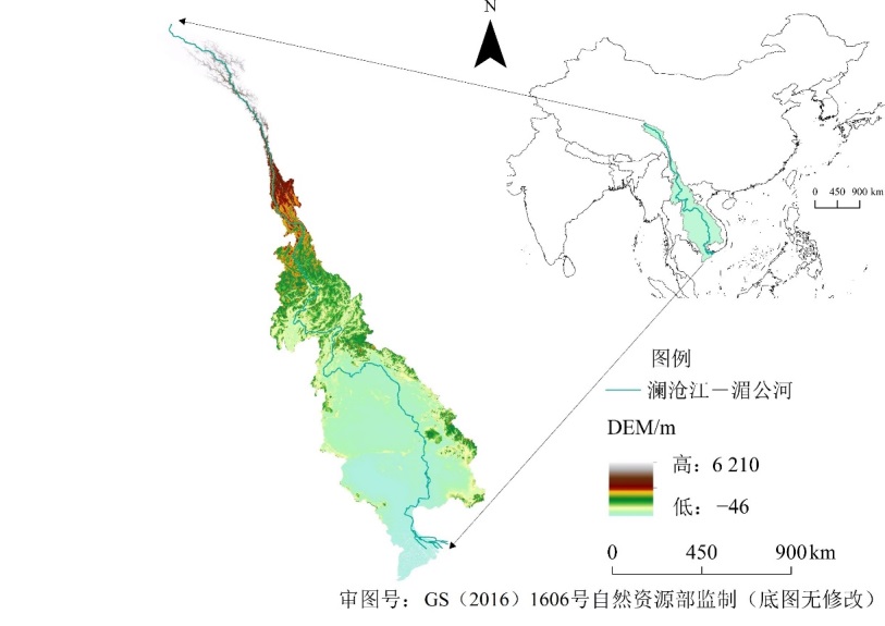
图1 澜沧江-湄公河流域地理位置
Figure 1 Geographical location of Lancang-Mekong River basin
| 分类 | 供给服务 | 调节服务 | 支持服务 | 文化服务 | ||||||||||
|---|---|---|---|---|---|---|---|---|---|---|---|---|---|---|
| 食物生产 | 原料生产 | 水资源供给 | 气体调节 | 气候调节 | 净化环境 | 水文调节 | 土壤保持 | 维持养分循环 | 生物多样性 | 美学景观 | ||||
| 农田 | 872 | 336 | −341 | 693 | 369 | 104 | 588 | 834 | 123 | 134 | 61 | |||
| 林地 | 234 | 534 | 275 | 1754 | 5255 | 1567 | 3883 | 2140 | 162 | 1949 | 856 | |||
| 草地 | 218 | 317 | 177 | 1124 | 2968 | 978 | 2175 | 1368 | 104 | 1241 | 548 | |||
| 湿地 | 482 | 472 | 2447 | 1795 | 3401 | 3401 | 22893 | 2183 | 170 | 7436 | 4469 | |||
| 裸地 | 0 | 0 | 0 | 19 | 0 | 94 | 28 | 19 | 0 | 19 | 9 | |||
| 水体 | 726 | 209 | 7606 | 706 | 2099 | 5044 | 20453 | 844 | 64 | 2315 | 1719 | |||
| 建设用地 | 0 | 0 | −64 | 489 | 909 | 488 | 790 | 196 | 45 | 296 | 287 | |||
表1 澜沧江-湄公河流域不同地类生态系统服务价值系数
Table 1 Ecosystem service value coefficient of each land use type in the Lancang-Mekong river basin
| 分类 | 供给服务 | 调节服务 | 支持服务 | 文化服务 | ||||||||||
|---|---|---|---|---|---|---|---|---|---|---|---|---|---|---|
| 食物生产 | 原料生产 | 水资源供给 | 气体调节 | 气候调节 | 净化环境 | 水文调节 | 土壤保持 | 维持养分循环 | 生物多样性 | 美学景观 | ||||
| 农田 | 872 | 336 | −341 | 693 | 369 | 104 | 588 | 834 | 123 | 134 | 61 | |||
| 林地 | 234 | 534 | 275 | 1754 | 5255 | 1567 | 3883 | 2140 | 162 | 1949 | 856 | |||
| 草地 | 218 | 317 | 177 | 1124 | 2968 | 978 | 2175 | 1368 | 104 | 1241 | 548 | |||
| 湿地 | 482 | 472 | 2447 | 1795 | 3401 | 3401 | 22893 | 2183 | 170 | 7436 | 4469 | |||
| 裸地 | 0 | 0 | 0 | 19 | 0 | 94 | 28 | 19 | 0 | 19 | 9 | |||
| 水体 | 726 | 209 | 7606 | 706 | 2099 | 5044 | 20453 | 844 | 64 | 2315 | 1719 | |||
| 建设用地 | 0 | 0 | −64 | 489 | 909 | 488 | 790 | 196 | 45 | 296 | 287 | |||
| 土地利用类型 | 1995年 | 2000年 | 2005年 | 2010年 | 2015年 | 2020年 | NDS | ADS | EPS |
|---|---|---|---|---|---|---|---|---|---|
| 农田 | 25.85 | 26.48 | 26.95 | 27.18 | 27.27 | 27.02 | 27.67 | 35.11 | 21.30 |
| 林地 | 34.91 | 34.25 | 33.27 | 32.28 | 31.73 | 32.21 | 28.21 | 24.30 | 31.14 |
| 草地 | 18.20 | 18.22 | 18.63 | 19.26 | 19.56 | 19.33 | 22.10 | 18.70 | 25.11 |
| 湿地 | 0.68 | 0.71 | 0.80 | 0.87 | 0.87 | 0.85 | 1.17 | 1.11 | 1.27 |
| 裸地 | 0.03 | 0.03 | 0.04 | 0.03 | 0.03 | 0.05 | 0.03 | 0.03 | 0.03 |
| 水体 | 1.16 | 1.12 | 1.10 | 1.15 | 1.18 | 1.19 | 1.25 | 1.19 | 1.56 |
| 建设用地 | 0.05 | 0.07 | 0.11 | 0.13 | 0.24 | 0.25 | 0.45 | 0.43 | 0.47 |
表2 2000-2020年间澜沧江-湄公河流域各类土地利用面积
Table 2 Area of different land use in the Lancang-Mekong river basin during 1995?2020 km2
| 土地利用类型 | 1995年 | 2000年 | 2005年 | 2010年 | 2015年 | 2020年 | NDS | ADS | EPS |
|---|---|---|---|---|---|---|---|---|---|
| 农田 | 25.85 | 26.48 | 26.95 | 27.18 | 27.27 | 27.02 | 27.67 | 35.11 | 21.30 |
| 林地 | 34.91 | 34.25 | 33.27 | 32.28 | 31.73 | 32.21 | 28.21 | 24.30 | 31.14 |
| 草地 | 18.20 | 18.22 | 18.63 | 19.26 | 19.56 | 19.33 | 22.10 | 18.70 | 25.11 |
| 湿地 | 0.68 | 0.71 | 0.80 | 0.87 | 0.87 | 0.85 | 1.17 | 1.11 | 1.27 |
| 裸地 | 0.03 | 0.03 | 0.04 | 0.03 | 0.03 | 0.05 | 0.03 | 0.03 | 0.03 |
| 水体 | 1.16 | 1.12 | 1.10 | 1.15 | 1.18 | 1.19 | 1.25 | 1.19 | 1.56 |
| 建设用地 | 0.05 | 0.07 | 0.11 | 0.13 | 0.24 | 0.25 | 0.45 | 0.43 | 0.47 |
| 土地利用类型 | NDS | ADS | EPS | |||||
|---|---|---|---|---|---|---|---|---|
| 面积/km2 | 比例/% | 面积/km2 | 比例/% | 面积/km2 | 比例/% | |||
| 农田 | 27.67 | 34.21 | 35.11 | 43.42 | 21.30 | 26.34 | ||
| 林地 | 28.21 | 34.88 | 24.30 | 30.05 | 31.14 | 38.51 | ||
| 草地 | 22.10 | 27.33 | 18.70 | 23.12 | 25.11 | 31.04 | ||
| 湿地 | 1.17 | 1.44 | 1.11 | 1.38 | 1.27 | 1.56 | ||
| 裸地 | 0.03 | 0.03 | 0.03 | 0.03 | 0.03 | 0.03 | ||
| 水体 | 1.25 | 1.54 | 1.19 | 1.47 | 1.56 | 1.93 | ||
| 建设用地 | 0.45 | 0.55 | 0.43 | 0.53 | 0.47 | 0.58 | ||
表3 不同情景下澜沧江-湄公河流域2040年各类土地利用面积
Table 3 Areas of the different land use types under each scenario for Lancang-Mekong river basin in 2040
| 土地利用类型 | NDS | ADS | EPS | |||||
|---|---|---|---|---|---|---|---|---|
| 面积/km2 | 比例/% | 面积/km2 | 比例/% | 面积/km2 | 比例/% | |||
| 农田 | 27.67 | 34.21 | 35.11 | 43.42 | 21.30 | 26.34 | ||
| 林地 | 28.21 | 34.88 | 24.30 | 30.05 | 31.14 | 38.51 | ||
| 草地 | 22.10 | 27.33 | 18.70 | 23.12 | 25.11 | 31.04 | ||
| 湿地 | 1.17 | 1.44 | 1.11 | 1.38 | 1.27 | 1.56 | ||
| 裸地 | 0.03 | 0.03 | 0.03 | 0.03 | 0.03 | 0.03 | ||
| 水体 | 1.25 | 1.54 | 1.19 | 1.47 | 1.56 | 1.93 | ||
| 建设用地 | 0.45 | 0.55 | 0.43 | 0.53 | 0.47 | 0.58 | ||

图2 澜沧江-湄公河流域2020年及3种土地利用情景模拟预测结果
Figure 2 Simulated LULC of Lancang-Mekong river basin for 2020 and 2040
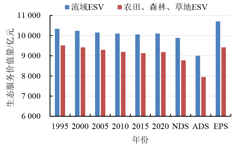
图3 澜沧江-湄公河流域ESV变化情况
Figure 3 ESV changes of Lancang?Mekong river basin from 1995 to 2040
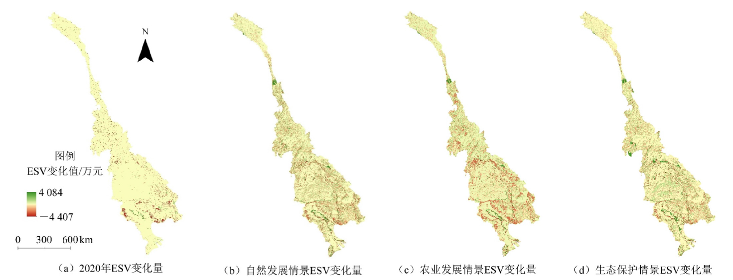
图4 澜沧江-湄公河流域不同发展情景下ESV变化空间分布格局
Figure 4 Spatial distribution pattern of ESV changes in Lancang-Mekong river basin under 3 scenarios in 2040
| 情景 | 高程 | 坡度 | 年均 降水 | 年均 气温 | 与水体距离 | 人口 密度 | 人类 足迹 |
|---|---|---|---|---|---|---|---|
| NDS | 0.202** 1) | 0.163** | 0.048** | 0.214** | 0.047** | 0.085** | 0.363** |
| ADS | 0.211** | 0.161** | 0.044** | 0.228** | 0.055** | 0.072** | 0.346** |
| EPS | 0.190** | 0.144** | 0.043** | 0.202** | 0.033** | 0.078** | 0.288** |
表4 不同情景下ESV空间变异性因子探测结果
Table 4 Factor detector of the drivers on ESV under each development scenario
| 情景 | 高程 | 坡度 | 年均 降水 | 年均 气温 | 与水体距离 | 人口 密度 | 人类 足迹 |
|---|---|---|---|---|---|---|---|
| NDS | 0.202** 1) | 0.163** | 0.048** | 0.214** | 0.047** | 0.085** | 0.363** |
| ADS | 0.211** | 0.161** | 0.044** | 0.228** | 0.055** | 0.072** | 0.346** |
| EPS | 0.190** | 0.144** | 0.043** | 0.202** | 0.033** | 0.078** | 0.288** |
| 情景 | 影响因子 | 高程 | 坡度 | 年均降水 | 年均气温 | 与水体距离 | 人口密度 |
|---|---|---|---|---|---|---|---|
| NDS | 人类足迹 | 0.449 | 0.399 | 0.418 | 0.452 | 0.379 | 0.371 |
| ADS | 0.427 | 0.380 | 0.390 | 0.439 | 0.360 | 0.353 | |
| EPS | 0.394 | 0.338 | 0.352 | 0.398 | 0.308 | 0.301 |
表5 不同情景下的ESV空间变异性交互探测结果
Table 5 Factor interaction detections on ESV under each development scenario
| 情景 | 影响因子 | 高程 | 坡度 | 年均降水 | 年均气温 | 与水体距离 | 人口密度 |
|---|---|---|---|---|---|---|---|
| NDS | 人类足迹 | 0.449 | 0.399 | 0.418 | 0.452 | 0.379 | 0.371 |
| ADS | 0.427 | 0.380 | 0.390 | 0.439 | 0.360 | 0.353 | |
| EPS | 0.394 | 0.338 | 0.352 | 0.398 | 0.308 | 0.301 |
| 情景 | I | Z(I) | E(I) | Z(G) | G | E(G) |
|---|---|---|---|---|---|---|
| NDS | 0.49 | 92.8 | 1×10⁻³ | 73.3 | 1×10⁻⁶ | 1×10⁻⁶ |
| ADS | 0.5 | 97.4 | 1×10⁻³ | 79.2 | 1×10⁻⁶ | 1×10⁻⁶ |
| EPS | 0.49 | 94.7 | 1×10⁻³ | 74.5 | 1×10⁻⁶ | 1×10⁻⁶ |
表6 澜沧江-湄公河流域空间自相关与高/低聚类指数
Table 6 Spatial autocorrelation and high/low clustering index of Lancang-Mekong river basin under 3 scenarios in 2040
| 情景 | I | Z(I) | E(I) | Z(G) | G | E(G) |
|---|---|---|---|---|---|---|
| NDS | 0.49 | 92.8 | 1×10⁻³ | 73.3 | 1×10⁻⁶ | 1×10⁻⁶ |
| ADS | 0.5 | 97.4 | 1×10⁻³ | 79.2 | 1×10⁻⁶ | 1×10⁻⁶ |
| EPS | 0.49 | 94.7 | 1×10⁻³ | 74.5 | 1×10⁻⁶ | 1×10⁻⁶ |
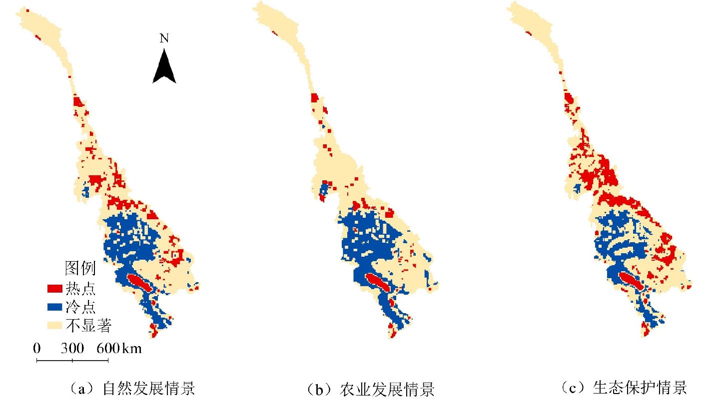
图5 澜沧江-湄公河流域未来不同发展情景下ESV热点/冷点区域空间分布格局
Figure 5 Hot/cold spot spatial distribution pattern of ESV in Lancang-Mekong river basin under 3 scenarios in 2040
| 情景 | TYPE | CA/km2 | NP | MPS/km2 | MSI | ED | MPI |
|---|---|---|---|---|---|---|---|
| NDS | 热点区域 | 91368 | 77 | 1186.60 | 1.40 | 0.14 | 19.47 |
| 冷点区域 | 181359 | 29 | 6253.76 | 1.49 | 0.15 | 172.46 | |
| ADS | 热点区域 | 47547 | 51 | 932.29 | 1.29 | 0.08 | 4.93 |
| 冷点区域 | 217566 | 28 | 7770.21 | 1.53 | 0.16 | 190.82 | |
| EPS | 热点区域 | 145233 | 71 | 2045.54 | 1.48 | 0.19 | 70.68 |
| 冷点区域 | 149850 | 40 | 3746.25 | 1.43 | 0.15 | 235.58 |
表7 澜沧江-湄公河流域冷点/热点区域类景观格局指数值
Table 7 Landscape metrics value of hot/cold spot area for the class type in Lancang-Mekong River basin
| 情景 | TYPE | CA/km2 | NP | MPS/km2 | MSI | ED | MPI |
|---|---|---|---|---|---|---|---|
| NDS | 热点区域 | 91368 | 77 | 1186.60 | 1.40 | 0.14 | 19.47 |
| 冷点区域 | 181359 | 29 | 6253.76 | 1.49 | 0.15 | 172.46 | |
| ADS | 热点区域 | 47547 | 51 | 932.29 | 1.29 | 0.08 | 4.93 |
| 冷点区域 | 217566 | 28 | 7770.21 | 1.53 | 0.16 | 190.82 | |
| EPS | 热点区域 | 145233 | 71 | 2045.54 | 1.48 | 0.19 | 70.68 |
| 冷点区域 | 149850 | 40 | 3746.25 | 1.43 | 0.15 | 235.58 |
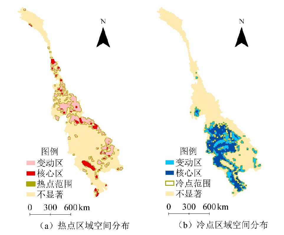
图6 澜沧江-湄公河流域ESV热点/冷点核心区域空间分布格局
Figure 6 Hot/cold spot core area distribution pattern of ESV in Lancang-Mekong river basin in 2040
| [1] | AKHTAR M, ZHAO Y Y, GAO G L, et al., 2020. Assessment of ecosystem services value in response to prevailing and future land use/cover changes in Lahore, Pakistan[J]. Regional Sustainability, 1(1): 37-47. |
| [2] | BERNABE J B, DAVID M, MORENO R T, et al., 2020. ARIES: Evaluation of a reliable and privacy-preserving European identity management framework[J]. Future Generation Computer Systems, 102: 409-425. |
| [3] | BRANDER L M, DE GROOT R, SCHÄGNER J P, et al., 2024. Economic values for ecosystem services: A global synthesis and way forward[J]. Ecosystem Services, 66(6630): 101606. |
| [4] | CHASIA S, OLANG L O, SITOKI L, 2023. Modelling of land-use/cover change trajectories in a transboundary catchment of the Sio-Malaba-Malakisi Region in East Africa using the CLUE-s model[J]. Ecological Modelling, 476(75): 110256. |
| [5] | COSTANZA R, D’ARGE R, DE GROOT R, et al., 1997. The value of the world’s ecosystem services and natural capital[J]. Nature, 387(6630): 253-260. |
| [6] | COSTANZA R, DE GROOT R, BRAAT L, et al., 2017. Twenty years of ecosystem services: How far have we come and how far do we still need to go[J]. Ecosystem Services, 28(3): 1-16. |
| [7] | DAILY G C, 1997. Nature’s services: Societal dependence on natural ecosystems[M]. Washington D. C.: Island Press: 57. |
| [8] | HAN Z, SONG W, 2022. Inter-annual trends of vegetation and responses to climate change and human activities in the Great Mekong Sub-region[J]. Global Ecology and Conservation, 38: e02215. |
| [9] | LI F X, LI Z F, CHEN H H, et al., 2020. An agent-based learning-embedded model (ABM-learning) for urban land use planning: A case study of residential land growth simulation in Shenzhen, China[J]. Land Use Policy, 95(24): 104620. |
| [10] | LIANG X, GUAN Q F, CLARKE K C, et al., 2021. Understanding the drivers of sustainable land expansion using a patch-generating land use simulation (PLUS) model: A case study in Wuhan, China[J]. Computers, Environment and Urban Systems, 85: 101569. |
| [11] | LIANG X, LIU X P, LI X, et al., 2018. Delineating multi-scenario urban growth boundaries with a CA-based FLUS model and morphological method[J]. Landscape and Urban Planning, 177: 47-63. |
| [12] | LOHANI S, DILTS T E, WEISBERG P J, et al., 2020. Rapidly accelerating deforestation in Cambodia’s Mekong River Basin: A comparative analysis of spatial patterns and drivers[J]. Water, 12(8): 2191. |
| [13] | Mekong River Commission. Enhancing the MRC land use and land cover 2020 mapping products[M]. Vientiane: Mekong River Commission Secretariat. |
| [14] |
MU H W, LI X C, WEN Y N, et al., 2022. A global record of annual terrestrial Human Footprint dataset from 2000 to 2018[J]. Scientific Data, 9(1): 176.
DOI PMID |
| [15] | MUNTHALI M G, MUSTAK S, ADEOLA A, et al., 2020. Modelling land use and land cover dynamics of Dedza district of Malawi using hybrid Cellular Automata and Markov model[J]. Remote Sensing Applications: Society and Environment, 17: 100276. |
| [16] | SHERROUSE B C, SEMMENS D J, ANCONA Z H, 2022. Social Values for Ecosystem Services (SolVES): Open-source spatial modeling of cultural services[J]. Environmental Modelling and Software, 148: 105259. |
| [17] | THI THU HA T, DIJK H, R. BUSH S, 2012. Mangrove conservation or shrimp farmer’s livelihood? The devolution of forest management and benefit sharing in the Mekong Delta, Vietnam[J]. Ocean & Coastal Management, 69: 185-193. |
| [18] | VEETTIL B K, QUANG N X, TRANG N T T, 2019. Changes in mangrove vegetation, aquaculture and paddy cultivation in the Mekong Delta: A study from Ben Tre Province, southern Vietnam[J]. Estuarine, Coastal and Shelf Science, 226: 106273. |
| [19] | WEN X, WANG J J, HAN X J, 2024. Impact of land use evolution on the value of ecosystem services in the returned farmland area of the Loess Plateau in northern Shaanxi[J]. Ecological Indicators, 163: 112119. |
| [20] | XIAO J, ZHANG Y F, XU H J, 2024. Response of ecosystem service values to land use change, 2002-2021[J]. Ecological Indicators, 160: 111947. |
| [21] | YANG X, YUAN X F, AN J J, et al., 2024. Drivers of ecosystem services and their trade-offs and synergies in different land use policy zones of Shaanxi Province, China[J]. Journal of Cleaner Production, 452: 142077. |
| [22] | 付梦娣, 唐文家, 刘伟玮, 等, 2021. 基于生态系统服务视角的生态风险评估及生态修复空间辨识——以长江源区为例[J]. 生态学报, 41(10): 3846-3855. |
| FU M D, TANG W J, LIU W W, et al., 2021. Ecological risk assessment and spatial identification of ecological restoration from the ecosystem service perspective: A case study in source region of Yangtze River[J]. Acta Ecologica Sinica, 41(10): 3846-3855. | |
| [23] | 胡和兵, 刘红玉, 郝敬锋, 等, 2013. 城市化流域生态系统服务价值时空分异特征及其对土地利用程度的响应[J]. 生态学报, 33(8): 2565-2576. |
| HU H B, LIU H Y, HAO J F, et al., 2013. Spatio-temporal variation in the value of ecosystem services and its response to land use intensity in an urbanized watershed[J]. Acta Ecologica Sinica, 33(8): 2565-2576. | |
| [24] | 雷金睿, 陈宗铸, 吴庭天, 等, 2019. 海南岛东北部土地利用与生态系统服务价值空间自相关格局分析[J]. 生态学报, 39(7): 2366-2377. |
| LEI J R, CHEN Z Z, WU T T, et al., 2019. Spatial autocorrelation pattern analysis of land use and the value of ecosystem services in northeast Hainan Island[J]. Acta Ecologica Sinica, 39(7): 2366-2377. | |
| [25] | 李丽, 王心源, 骆磊, 等, 2018. 生态系统服务价值评估方法综述[J]. 生态学杂志, 37(4): 1233-1245. |
| LI L, WANG X Y, LUO L, et al., 2018. A systematic review on the methods of ecosystem services value assessment[J]. Chinese Journal of Ecology, 37(4): 1233-1245. | |
| [26] |
乔斌, 祝存兄, 曹晓云, 等, 2020. 格网尺度下青海玛多县土地利用及生态系统服务价值空间自相关分析[J]. 应用生态学报, 31(5): 1660-1672.
DOI |
|
QIAO B, ZHU C X, CAO X Y, et al., 2020. Spatial autocorrelation analysis of land use and ecosystem service value in Maduo County, Qinghai Province, China at the grid scale[J]. Chinese Journal of Applied Ecology, 31(5): 1660-1672.
DOI |
|
| [27] |
王劲峰, 徐成东, 2017. 地理探测器: 原理与展望[J]. 地理学报, 72(1): 116-134.
DOI |
|
WANG J F, XU C D, 2017. Geodetector: Principle and prospective[J]. Acta Geographica Sinica, 72(1): 116-134.
DOI |
|
| [28] | 危小建, 辛思怡, 张颖艺, 等, 2023. 不同格网尺度下生态系统服务价值空间分异及其影响因素差异——以大南昌都市圈为例[J]. 生态学报, 43(18): 7585-7597. |
| WEI X J, XIN S Y, ZHANG Y Z, et al., 2023. Spatial difference of ecological services and its influencing factors under different scales: Taking the Nanchang Urban Agglomeration as an example[J]. Acta Ecologica Sinica, 43(18): 7585-7597. | |
| [29] | 谢高地, 张彩霞, 张雷明, 等, 2015. 基于单位面积价值当量因子的生态系统服务价值化方法改进[J]. 自然资源学报, 30(8): 1243-1254. |
|
XIE G D, ZHANG C X, ZHANG L M, et al., 2015. Improvement of the evaluation method for ecosystem service value based on per unit area[J]. Journal of Natural Resources, 30(8): 1243-1254.
DOI |
|
| [30] | 殷楠, 王帅, 刘焱序, 2021. 生态系统服务价值评估: 研究进展与展望[J]. 生态学杂志, 40(1): 233-244. |
|
YIN N, WANG S, LIU Y X, et al., 2021. Ecosystem service value assessment: Research progress and prospects[J]. Chinese Journal of Ecology, 40(1): 233-244.
DOI |
| [1] | 张洪波, 尹班, 李春勇, 崔松云, 和艳, 李小红, 邓丽仙. 近40年红河流域(中国部分)水源涵养功能动态演变特征及驱动因素[J]. 生态环境学报, 2025, 34(4): 556-569. |
| [2] | 张任菲, 肖萌, 刘志成. 京津冀地区景观破碎化的时空异质性及驱动因素研究[J]. 生态环境学报, 2025, 34(3): 461-473. |
| [3] | 李曼, 吴东丽, 何昊, 余慧婕, 赵琳, 刘聪, 胡正华, 李琪. 1990-2020年黄河流域碳储量时空演变及驱动因素研究[J]. 生态环境学报, 2025, 34(3): 333-344. |
| [4] | 郭昭, 师芸, 刘铁铭, 张雨欣, 闫永智. 2001-2020年秦岭北麓NPP时空格局及驱动因素分析[J]. 生态环境学报, 2025, 34(3): 401-410. |
| [5] | 赵忠宝, 李婧, 刘小丹, 柏祥, 刘昊野, 徐晓娜, 耿世刚, 鲁少波. 河北省森林生态产品价值评估及其空间分布驱动因素研究[J]. 生态环境学报, 2025, 34(2): 321-332. |
| [6] | 赵乐鋆, 王诗瑶, 赵子渝, 洪星, 李夫星, 吴佳仪, 华婧妤. 2008-2022年华北平原七省市AOD时空变化特征及主要影响因素分析[J]. 生态环境学报, 2025, 34(2): 256-267. |
| [7] | 汪洋, 李帆, 严笑, 梅言, 李培, 黄林, 赵俊杰. 山地高密度城市空间形态对冬季气溶胶格局的约束力探测——重庆中心城区案例研究[J]. 生态环境学报, 2025, 34(1): 56-66. |
| [8] | 叶俊宏, 刘珍环, 刘子瑜. 珠江三角洲城市群国土空间生态修复分区情景模拟[J]. 生态环境学报, 2025, 34(1): 4-12. |
| [9] | 张舒涵, 姜海玲, 于海淋, 冯馨慧. 沈阳现代化都市圈景观生态风险时空演变及驱动力分析[J]. 生态环境学报, 2024, 33(9): 1471-1481. |
| [10] | 奥勇, 张龙, 王晓峰, 吴彦芸, 唐冰倩, 张亦恒. 基于“自然-社会”视角的陕西省土地利用变化碳核算与演变格局分析[J]. 生态环境学报, 2024, 33(8): 1306-1317. |
| [11] | 戴晓爱, 马佳欣, 唐艺菱, 李为乐. 甘肃省植被时空动态变化及其归因分析[J]. 生态环境学报, 2024, 33(8): 1163-1173. |
| [12] | 王雪融, 龚建周, 俞方圆. 粤港澳大湾区4种生态系统调节服务的互馈关系及机制[J]. 生态环境学报, 2024, 33(7): 1130-1141. |
| [13] | 张维琛, 王惺琪, 王博杰. 塔布河流域生态系统服务时空格局及影响因素分析[J]. 生态环境学报, 2024, 33(7): 1142-1152. |
| [14] | 廖洪圣, 卫伟, 石宇. 黄土丘陵区典型流域土壤侵蚀时空演变特征及其驱动机制:以祖厉河为例[J]. 生态环境学报, 2024, 33(6): 908-918. |
| [15] | 李慧, 邓佳伟, 李亚鑫, 母滢琦. 秦岭北麓典型流域径流对气候和土地利用变化的响应——以灞河流域为例[J]. 生态环境学报, 2024, 33(5): 802-811. |
| 阅读次数 | ||||||
|
全文 |
|
|||||
|
摘要 |
|
|||||