生态环境学报 ›› 2023, Vol. 32 ›› Issue (6): 1078-1088.DOI: 10.16258/j.cnki.1674-5906.2023.06.009
董洁芳1( ), 邓椿2,*(), 张仲伍3
收稿日期:2022-09-30
出版日期:2023-06-18
发布日期:2023-09-01
通讯作者:
*邓椿(1981年生),男,博士研究生,主要研究方向为水文生态。E-mail: 202010225@stumail.nwu.edu.cn作者简介:董洁芳(1984年生),女,副教授,博士,硕士研究生导师,主要研究方向为区域经济与生态旅游开发。E-mail: dongjiefang-2005@163.com
基金资助:
DONG Jiefang1(), DENG Chun2,*(), ZHANG Zhongwu3
Received:2022-09-30
Online:2023-06-18
Published:2023-09-01
摘要:
研究PM2.5时空演化及人口暴露风险,对于环境风险评价及人居环境改善、政府环保部门制定针对性的空气污染防控政策具有重要意义。渭河流域是国家重要工业基地,也是国家级城市群和关中—天水国家级经济区的核心区域,降低该区域PM2.5人口暴露风险是实现高质量发展的必然途径。基于渭河流域2000—2020年PM2.5遥感反演数据和人口格网分布数据,测算人口暴露风险指数。采用Theil-Sen Median与Mann Kendall检验法,分别识别PM2.5质量浓度值和人口暴露风险指数时间演化特征,并通过GIS空间探索工具,分析其空间变化特征。结果表明,(1)2000—2020年渭河流域PM2.5年均质量浓度为47.2 μg·m-3,最高值为2013年的57.6 μg·m-3,最低值为2020年的31.8 μg·m-3,呈现先上升后下降的变化趋势。趋势显著性检验发现,渭河流域PM2.5污染情况呈现好转趋势。(2)PM2.5年均质量浓度空间分布呈东高西低特征,高值主要集中在流域下游地区,如西安市、咸阳市和渭南市等。低值主要分布在流域中上游地区,如天水市、定西市、平凉市等。(3)2000—2020年渭河流域PM2.5人口暴露风险等级总体呈下降趋势,但历年暴露于35 μg·m-3以上人数占比均值高达96.2%。2000—2003年,2005—2014年间,渭河流域100%人口暴露于浓度值35 μg·m-3以上。但高风险区域面积从2000年的20.6%下降为2020年的17.1%。(4)2000—2020年渭河流域历年PM2.5人口暴露风险等级均呈现东高西低的空间格局,且空间差异较大,“热点”型主要集中渭城区、秦都区、未央区等城市建成区单元,“冷点”型主要分布在定西市、天水市、平凉市等流域西部海拔较高区域。研究结论可为渭河流域制定联防联控的PM2.5污染治理政策提供科学依据。
中图分类号:
董洁芳, 邓椿, 张仲伍. 渭河流域PM2.5时空演化及人口暴露风险[J]. 生态环境学报, 2023, 32(6): 1078-1088.
DONG Jiefang, DENG Chun, ZHANG Zhongwu. Spatio-temporal Evolution and Population Exposure Risk to PM2.5 in the Weihe River Basin[J]. Ecology and Environment, 2023, 32(6): 1078-1088.
| β值 | Z值 | 趋势特征 |
|---|---|---|
| β>0 | 2.58<Z | 极显著增加 |
| 1.96<Z≤2.58 | 显著增加 | |
| 1.65<Z≤1.96 | 微显著增加 | |
| Z≤1.65 | 不显著增加 | |
| β=0 | Z | 无变化 |
| β<0 | Z≤1.65 | 不显著减少 |
| 1.65<Z≤1.96 | 微显著减少 | |
| 1.96<Z≤2.58 | 显著减少 | |
| 2.58<Z | 极显著减少 |
表1 Mann-Kendall检验趋势显著性类别
Table 1 Mann-Kendall test trend categories
| β值 | Z值 | 趋势特征 |
|---|---|---|
| β>0 | 2.58<Z | 极显著增加 |
| 1.96<Z≤2.58 | 显著增加 | |
| 1.65<Z≤1.96 | 微显著增加 | |
| Z≤1.65 | 不显著增加 | |
| β=0 | Z | 无变化 |
| β<0 | Z≤1.65 | 不显著减少 |
| 1.65<Z≤1.96 | 微显著减少 | |
| 1.96<Z≤2.58 | 显著减少 | |
| 2.58<Z | 极显著减少 |
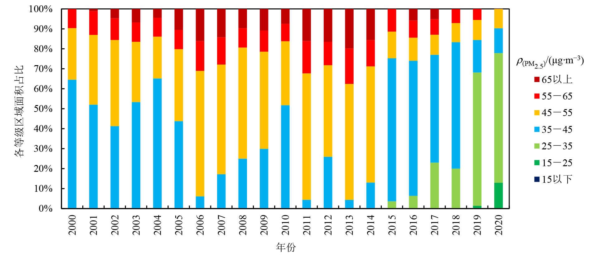
图1 2000—2020年渭河流域PM2.5质量浓度分区间面积占比
Figure 1 Area proportion of PM2.5 concentration in Weihe River Basin from 2000 to 2020
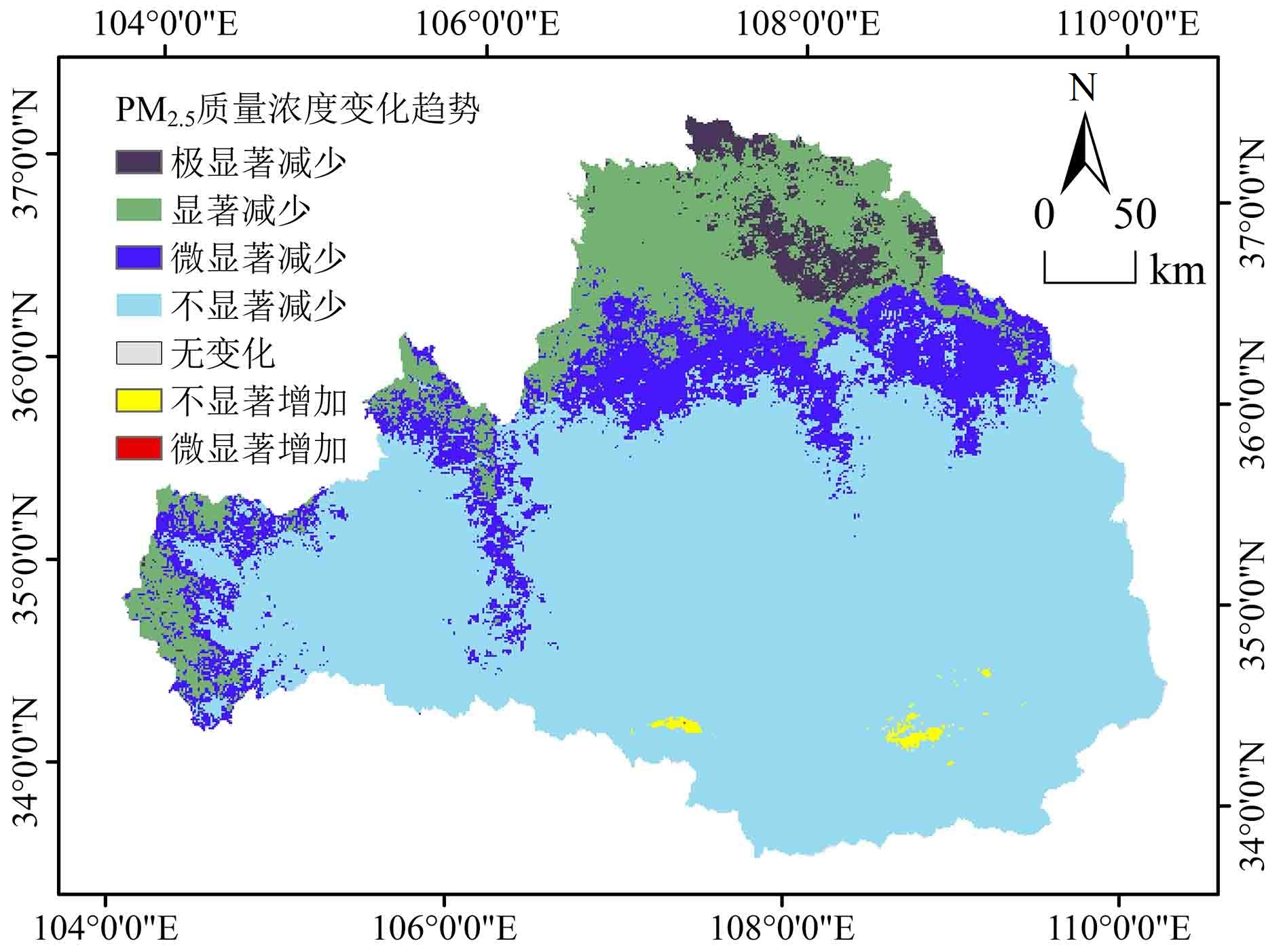
图2 2000—2020年渭河流域PM2.5质量浓度变化趋势
Figure 2 Trends of PM2.5 concentration by types in the Weihe River basin from 2000 to 2020
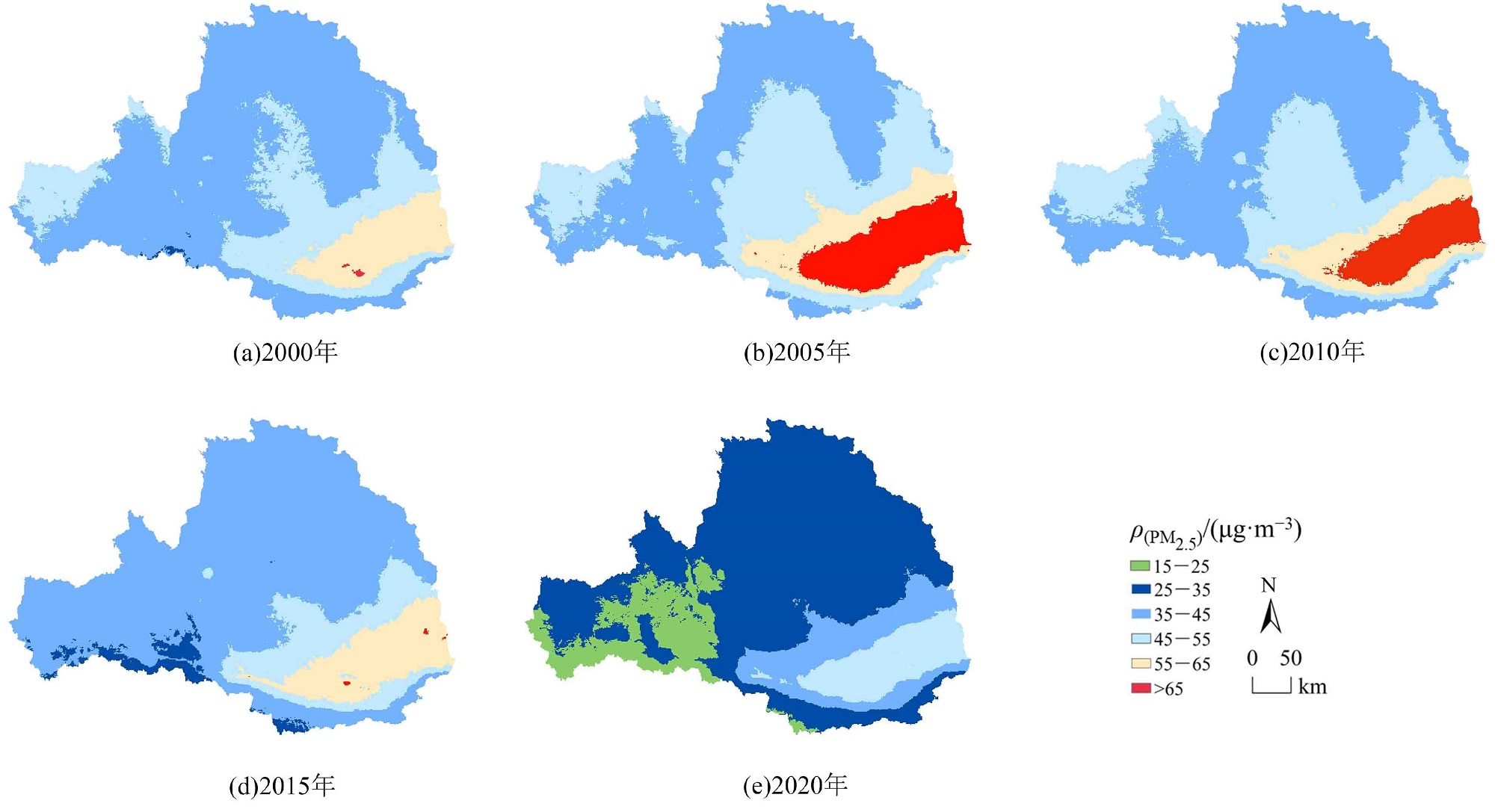
图3 2000—2020年渭河流域PM2.5质量浓度空间分布
Figure 3 Spatial distribution of PM2.5 annual concentration in the Weihe River basin from 2000 to 2020
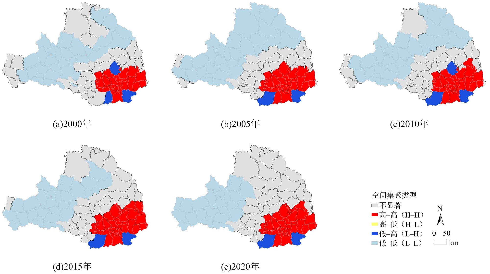
图4 2000—2020年渭河流域区PM2.5质量浓度空间集聚图
Figure 4 Spatial clusters of PM2.5 annual concentration in the Weihe River basin from 2000 to 2020
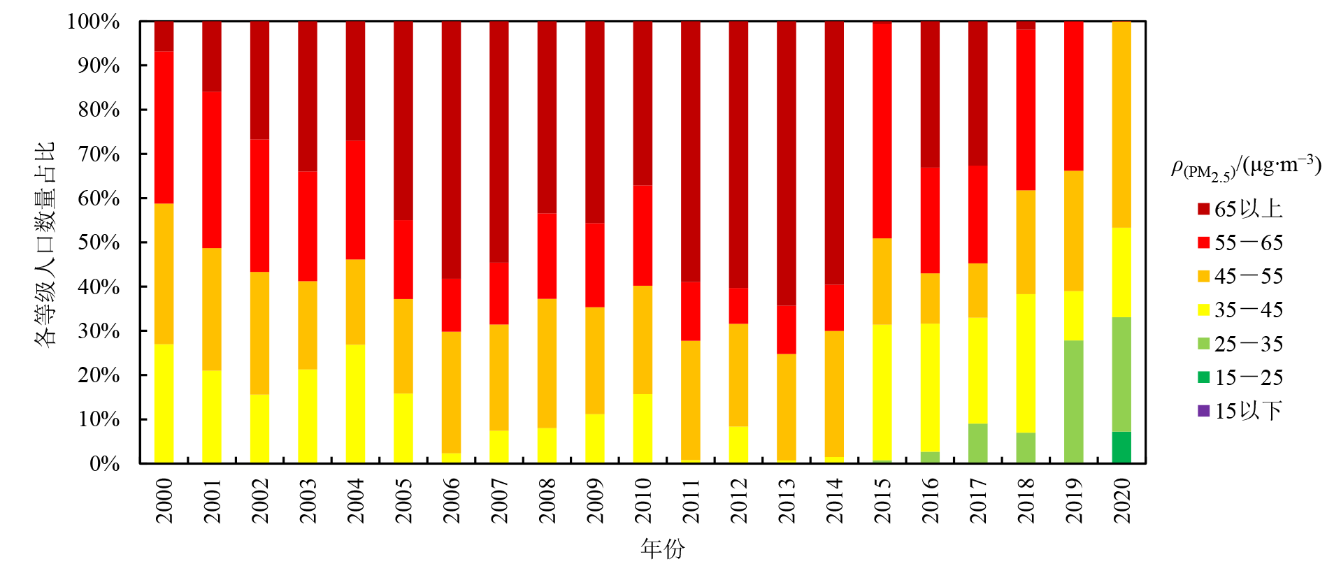
图5 2000—2020年渭河流域PM2.5质量浓度分区间人口暴露数量占比
Figure 5 The proportion of the population exposure risk to PM2.5 concentrations in the Weihe River basin from 2000 to 2020
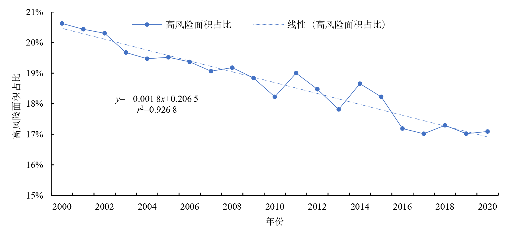
图6 2000—2020年渭河流域人口暴露高等级风险区面积占比趋势
Figure 6 Trend of area proportion of population exposure high-level risk to PM2.5 in the Weihe River basin from 2000 to 2020
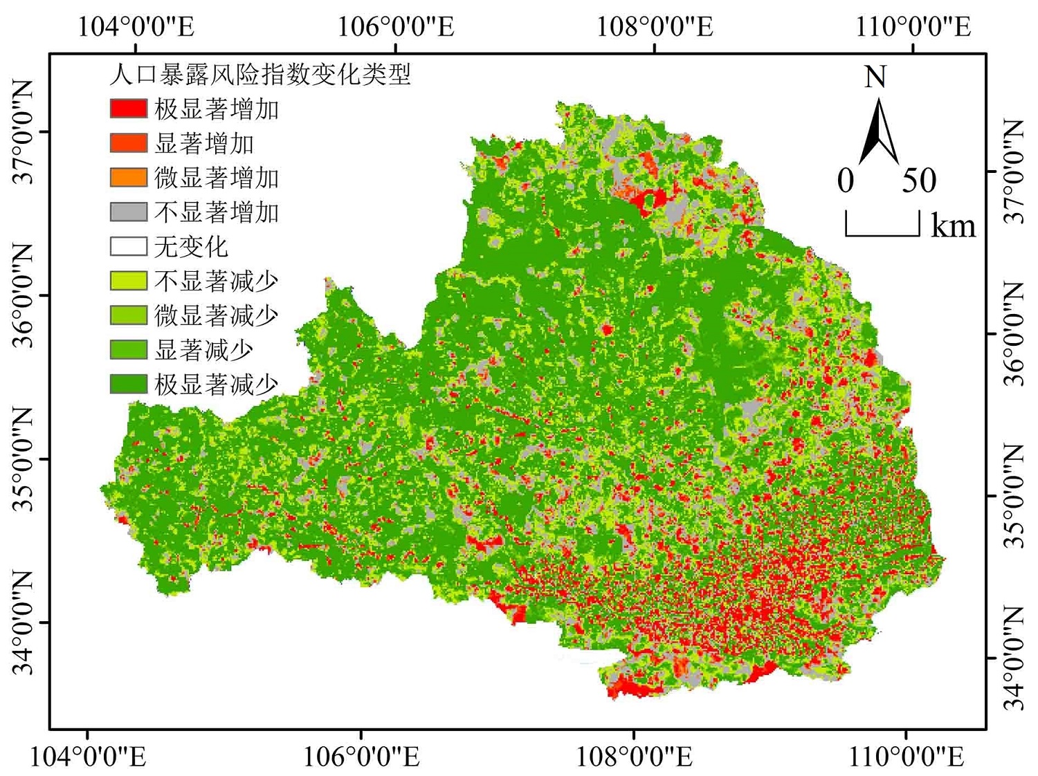
图7 2000—2020年渭河流域PM2.5人口风险暴露指数线性变化趋势
Figure 7 Trend of population exposure risk to PM2.5 by type in the Weihe River basin from2000 to 2020
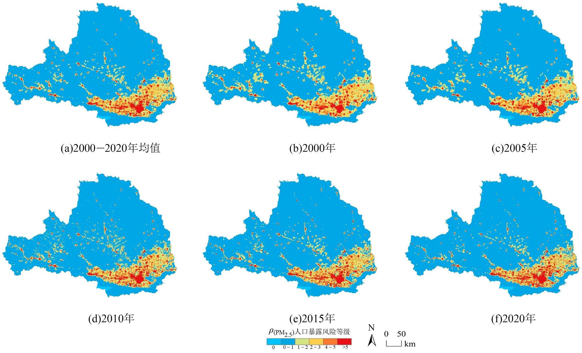
图8 2000—2020年渭河流域PM2.5人口暴露风险等级空间格局
Figure 8 Spatial pattern of population exposure risk to PM2.5 in the Weihe River basin from 2000 to 2020
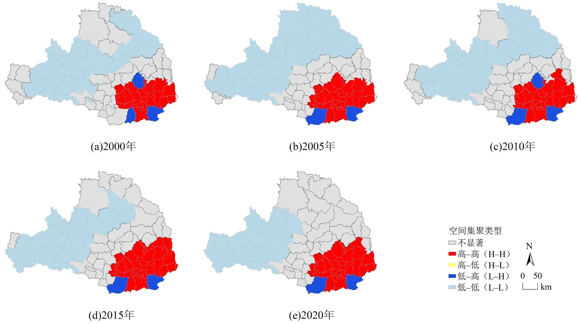
图9 2000—2020年渭河流域PM2.5人口暴露风险局部空间集聚类型
Figure 9 Spatial clusters of population exposure risk to PM2.5 n the Weihe River basin from 2000 to 2020
| [1] |
DONKELAAR A, MARTIN R V, LEVY R C, et al., 2011. Satellite-based estimates of ground-level fine particulate matter during extreme events: A case study of the Moscow fires in 2010[J]. Atmospheric Environment, 45(34): 6225-6232.
DOI URL |
| [2] |
BECKERMAN B S, JERRETT M, SERRE M, et al., 2013. A hybrid approach to estimating national scale spatiotemporal variability of PM2.5 in the contiguous United States[J]. Environmental Science & Technology, 47(13): 7233-7241.
DOI URL |
| [3] |
YANG Y, CHRISTAKOS G, 2015. Spatiotemporal characterization of ambient PM2.5 concentrations in Shandong province (China)[J]. Environmental Science & Technology, 49(22): 13431-13438.
DOI URL |
| [4] |
GAO M L, CAO J J, SETO E, 2015. A distributed network of low-cost continuous reading sensors to measure spatiotemporal variations of PM2.5 in Xi’an, China[J]. Environmental Pollution, 199: 56-65.
DOI URL |
| [5] |
HAN L J, ZHOU W Q, LI W F, 2015. City as a major source area of fine particulate (PM2.5) in China[J]. Environmental Pollution, 206: 183-187.
DOI PMID |
| [6] |
LIU X J, XIA S Y, YANG Y, et al., 2020. Spatiotemporal dynamics and impacts of socioeconomic and natural conditions on PM2.5 in the Yangtze River economic belt[J]. Environmental Pollution, 263(Part A): 114569.
DOI URL |
| [7] |
WEI J, HUANG W, LI Z Q, et al., 2019. Estimating 1-km-resolution PM2.5 concentrations across China using the space-time random forest approach[J]. Remote Sensing of Environment, 231: 111221.
DOI URL |
| [8] |
XU W J, ZENG Z T, XU Z Y, et al., 2020. Public health benefits of optimizing urban industrial land layout-The case of Changsha, China[J]. Environmental Pollution, 263(Part B): 114388.
DOI URL |
| [9] |
YAN R H, PENG X, LIN W, et al., 2022. Trends and challenges regarding the source-specific health risk of PM2.5-bound metals in a Chinese megacity from 2014 to 2020[J]. Environment Science Technology, 56(11): 6996-7005.
DOI URL |
| [10] |
ZHANG L C, AN J, LIU M Y, et al., 2020. Spatiotemporal variations and influencing factors of PM2.5 concentrations in Beijing, China[J]. Environmental Pollution, 262: 114276.
DOI URL |
| [11] | 陈登帅, 李晶, 杨晓楠, 等, 2018. 渭河流域生态系统服务权衡优化研究[J]. 生态学报, 38(9): 3260-3271. |
| CHEN D S, LI J, YANG X N, et al., 2018. Trade-offs and optimization among ecosystem services in the Weihe River Basin[J]. Acta Ecologica Sinica, 38(9): 3260-3271. | |
| [12] | 邓芙蓉, 王欣, 苏会娟, 等, 2009. 北京市某城区儿童大气PM2.5个体暴露水平及影响因素研究[J]. 环境与健康杂志, 26(9): 762-765. |
| DENG F R, WANG X, SU H J, et al., 2009. Personal exposure to PM2.5 of children living near traffic road and the influencing factors in Beijing[J]. Journal of Environment and Health, 26(9): 762-765. | |
| [13] | 董海燕, 潘耀忠, 朱秀芳, 等, 2022. 多因子贡献率权重的城市精细人口空间化方法: 以北京市为例[J]. 北京师范大学学报(自然科学版), 58(1): 135-142. |
| DONG H Y, PAN Y Z, ZHU X F, et al., 2022. Spatial method of urban fine population with multifactor contribution rate weight: Case of Beijing[J]. Journal of Beijing Normal University (Natural Science), 58(1): 135-142. | |
| [14] |
郝永佩, 宋晓伟, 赵文珺, 等, 2022. 汾渭平原大气污染时空分布及相关因子分析[J]. 生态环境学报, 31(3): 512-523.
DOI |
| HAO Y P, SONG X W, ZHAO W J, et al., 2022. Spatiotemporal distribution of air pollution and correlation factors in Fenwei Plain[J]. Ecology and Environmental Sciences, 31(3): 512-523. | |
| [15] |
郭雯雯, 陈永金, 刘阁, 等, 2020. 2016-2019年长江中游城市群空气质量时空变化特征及影响因素分析[J]. 生态环境学报, 29(10): 2034-2044.
DOI |
| GUO W W, CHEN Y J, LIU G, et al., 2020. Analysis on the characteristics and influencing factors of air quality of urban agglomeration in the middle reaches of the Yangtze River in 2016 to 2019[J]. Ecology and Environmental Sciences, 29(10): 2034-2044. | |
| [16] | 黄小刚, 赵景波, 曹军骥, 等, 2020. 长江经济带PM2.5分布格局演变及其影响因素[J]. 环境科学, 41(3): 1013-1024. |
| HUANG X G, ZHAO J B, CAO J J, et al., 2020. Evolution of the distribution of PM2.5concentration in the Yangtze River economic belt and its influencing factors[J]. Environmental Science, 41(3): 1013-1024. | |
| [17] | 黄晓军, 祁明月, 李艳雨, 等, 2020. 关中地区PM2.5时空演化及人口暴露风险[J]. 环境科学, 41(12): 5245-5255. |
|
HUANG X J, QI M Y, LI Y Y, et al., 2020. Spatio-temporal evolution and population exposure risk to PM2.5in the Guanzhong area[J]. Environmental Science, 41(12): 5245-5255.
DOI URL |
|
| [18] | 柯钊跃, 王佳, 郑君瑜, 等, 2011. 广州市学龄儿童在校期间PM2.5暴露水平评价[J]. 中国环境科学, 31(10): 1618-1624. |
| KE Z Y, WANG J, ZHENG J Y, et al., 2011. PM2.5exposure assessment of school children at a primary school in Guangzhou, China[J]. China Environmental Science, 31(10): 1618-1624. | |
| [19] | 李佳雯, 2020. 基于多源卫星遥感的长三角PM2.5污染人口暴露度时空分布研究[D]. 南京: 南京信息工程大学:12-26. |
| LI J W, 2020. Spatial-temporal distribution characteristics of PM2.5pollution exposure based on multi-source satellite Remote Sensing of population in the Yangtze River delta[D]. Nanjing: Nanjing University of Information Science and Technology:12-26. | |
| [20] | 廖林渲, 陈静, 2022. 河南省PM2.5暴露人口时空特征及影响因素研究[J]. 福建师范大学学报 (自然科学版), 38(1): 59-68. |
| LIAO L X, CHEN J, 2022. Study on the spatiotemporal characteristics and influencing factors of population exposure to particulate matter (PM2.5) in Henan province[J]. Journal of Fujian Normal University (Natural Science Edition), 38(1): 59-68. | |
| [21] |
林丹淳, 谭敏, 刘凯, 等, 2020. 代表性人口空间分布数据集的精度评价——以2010年广东省为例[J]. 热带地理, 40(2): 346-356.
DOI |
|
LIN D C, TAN M, LIU K, et al., 2020. Accuracy comparison of four gridded population datasets in Guangdong province, China[J]. Tropical Geography, 40(2): 346-356.
DOI |
|
| [22] |
林金煌, 陈文惠, 张岸, 2020. 2019年北京市PM2.5人群暴露剂量特征分析[J]. 地球信息科学学报, 22(12): 2348-2357.
DOI |
| LIN J H, CHEN W H, ZHANG A, 2020. Analysis of PM2.5 population exposure doses characteristics in Beijing in 2019[J]. Journal of Geo-information Science, 22(12): 2348-2357. | |
| [23] | 刘修岩, 李松林, 秦蒙, 2016. 开发时滞、市场不确定性与城市蔓延[J]. 经济研究, 51(8): 159-171, 186. |
| LIU X Y, LI S L, QIN M, 2016. Development lag, market uncertainty and urban sprawl[J]. Economic Research Journa, l51(8): 159-171, 186. | |
| [24] |
宓科娜, 庄汝龙, 梁龙武, 等, 2018. 长三角PM2.5时空格局演变与特征——基于2013-2016年实时监测数据[J]. 地理研究, 37(8): 1641-1654.
DOI |
| MI K N, ZHUANG R L, LIANG L W, et al., 2018. Spatio-temporal evolution and characteristics of PM2.5 in the Yangtze River Delta based on real-time monitoring data during 2013-2016[J]. Geographical Research, 37(8): 1641-1654. | |
| [25] | 慕航, 何超, 阮秋明, 等, 2021. “一带一路”沿线国家PM2.5污染与人口暴露风险的时空分布特征[J]. 环境科学学报, 41(6): 2229-2240. |
| MU H, HE C, RUAN Q M, et al., 2021. Spatiotemporal distribution characteristics and population exposure risks to PM2.5in countries along the Belt and Road[J]. Acta Scientiae Circumstantiae, 41(6): 2229-2240. | |
| [26] | 王睿哲, 2021. 关中平原城市群大气污染物浓度模拟及人口暴露研究[D]. 西安: 西安科技大学:65-68. |
| WANG R Z, 2021. Research on air pollutant concentration simulation and population exposure in Guanzhong Plain urban agglomeration[D]. Xi’an: Xi’an University of Science and Technology:65-68. | |
| [27] | 王钊, 韩斌, 倪天茹, 等, 2013. 天津市某社区老年人PM2.5暴露痕量元素健康风险评估[J]. 环境科学研究, 26(8): 913-918. |
| WANG Z, HAN B, NI T R, et al., 2013. Health risk assessment of trace elements of PM2.5exposure for the elderly subpopulation in Tianjin, China[J]. Research of Environmental Sciences, 26(8): 913-918. | |
| [28] |
肖嘉玉, 何超, 慕航, 等, 2021. 中国城市空气污染时空分布格局和人口暴露风险[J]. 地理科学进展, 40(10): 1650-1663.
DOI |
|
XIAO J Y, HE C, MU H, et al., 2021. Spatiotemporal pattern and population exposure risks of air pollution in Chinese urban areas[J]. Progress in Geography, 40(10): 1650-1663.
DOI |
|
| [29] | 谢杨, 戴瀚程, 花岡達也, 等, 2016. PM2.5污染对京津冀地区人群健康影响和经济影响[J]. 中国人口·资源与环境, 26(11): 19-27. |
| XIE Y, DAI H C, HANAOKA T, et al., 2016. Health and economic impacts of PM2.5 pollution in Beijing-Tianjin-Hebei area[J]. China Population, Resources and Environment, 26(11): 19-27. | |
| [30] | 徐建华, 2017. 现代地理学中的数学方法[M]. 第3版. 北京: 高等教育出版社: 225-228. |
| XU J H, 2017. Mathematical methods in contemporary geography[M]. Third Edition. Beijing: Higher Education Press: 225-228. | |
| [31] | 徐宗学, 刘麟菲, 2021. 渭河流域水生态系统健康评价[J]. 人民黄河, 43(10): 40-43, 50. |
| XU Z X, LIU L F, 2021. Assessment on the aquatic ecosystem health of the Weihe River Basin based on periphyton[J]. Yellow River, 43(10): 40-43, 50. | |
| [32] |
杨晴青, 刘倩, 尹莎, 等, 2019. 秦巴山区乡村交通环境脆弱性及影响因素——以陕西省洛南县为例[J]. 地理学报, 74(6): 1236-1251.
DOI |
| YANG Q Q, LIU Q, YIN S, et al., 2019. Vulnerability and influencing factors of rural transportation environment in Qinling-Daba mountainous areas:A case study of Luonan county in Shaanxi province[J]. Acta Geographica Sinica, 74(6): 1236-1251. | |
| [33] |
么相姝, 赵文吉, 杨振宇, 等, 2021. 基于Ward系统聚类的京津冀城市群空气质量时空变化特征与成因分析[J]. 生态环境学报, 30(2): 340-350.
DOI |
| YAO X S, ZHAO W J, YANG Z Y, et al., 2021. Spatial-temporal variation characteristics of air quality and its influencing factors of the Beijing-Tianjin-Hebei urban agglomeration based on ward hierarchical clustering[J]. Ecology and Environmental Sciences, 30(2): 340-350. | |
| [34] | 张亮林, 潘竟虎, 2021. 全球PM2.5人口暴露风险时空格局[J]. 中国环境科学, 41(11): 5391-5404. |
| ZHANG L L, PAN J H, 2021. Spatial-temporal pattern of population exposure risk to PM2.5in global[J]. China Environmental Science, 41(11): 5391-5404. | |
| [35] | 张亮林, 潘竟虎, 2020. 中国PM2.5人口暴露风险时空格局[J]. 中国环境科学, 40(1): 1-12. |
| ZHANG L L, PAN J H, 2020. Spatial-temporal pattern of population exposure risk to PM2.5 in China[J]. China Environmental Science, 40(1): 1-12. | |
| [36] | 张西雅, 扈海波, 2018. 基于多源数据的北京地区PM2.5暴露风险评估[J]. 北京大学学报 (自然科学版), 54(5): 1103-1113. |
| ZHANG X Y, HU H B, 2018. Risk assessment of exposure to PM2.5in Beijing using multi-source data[J]. Acta Scientiarum Naturalium Universitatis Pekinensis, 54(5): 1103-1113. | |
| [37] | 张音, 古丽贤·吐尔逊拜, 苏里坦, 等, 2019. 近60 a来新疆不同海拔气候变化的时空特征分析[J]. 干旱区地理, 42(4): 822-829. |
| ZHANG Y, TUERXUNBAI G LX, SU L T, et al., 2019. Spatial and temporal characteristics of climate change at different altitudes in Xinjiang in the past 60 years[J]. Arid Land Geography, 42(4): 822-829. | |
| [38] | 赵辉, 郑有飞, 张誉馨, 等, 2020. 京津冀大气污染的时空分布与人口暴露[J]. 环境科学学报, 40(1): 1-12. |
| ZHAO H, ZHENG Y F, ZHANG Y X, et al., 2020. Spatiotemporal distribution and population exposure of air pollution in Beijing-Tianjin-Hebei region[J]. Acta Scientiae Circumstantiae, 40(1): 1-12. | |
| [39] | 中华人民共和国环境保护部, 2012. 环境空气质量指数 (AQI) 技术规定(试行): HJ 633—2012[S]. 北京: 环境保护部: 1-6. |
| Ministry of Ecology and Environment of the People’s Republic of China, 2012. Technical Regulation on Ambient Air Quality Index (on trial): HJ 633—2012[S]. Beijing: Ministry of Ecology and Environment: 1-6. | |
| [40] |
周亮, 周成虎, 杨帆, 等, 2017. 2000-2011年中国PM2.5时空演化特征及驱动因素解析[J]. 地理学报, 72(11): 2079-2092.
DOI |
| ZHOU L, ZHOU C H, YANG F, et al., 2017. Spatio-temporal evolution and the influencing factors of PM2.5 in China between 2000 and 2011[J]. Acta Geographica Sinica, 72(11): 2079-2092. | |
| [41] |
周旗, 张海宁, 任源鑫, 2020. 1961-2016年渭河流域极端降水事件研究[J]. 地理科学, 40(5): 833-841.
DOI |
|
ZHOU Q, ZHANG H N, REN Y X, 2020. Extreme precipitation events in the Weihe River Basin from 1961 to 2016[J]. Scientia Geographica Sinica, 40(5): 833-841.
DOI |
|
| [42] | 邹滨, 彭芬, 焦利民, 等, 2013. 高分辨率人口空气污染暴露GIS空间区划研究[J]. 武汉大学学报 (信息科学版), 38(3): 334-338. |
| ZOU B, PENG F, JIAO L M, et al., 2013. GIS aided spatial zoning of high-resolution population exposure to air pollution[J]. Geomatics and Information Science of Wuhan University, 38(3): 334-338. |
| [1] | 巫晨煜, 许帆帆, 魏士博, 樊晶晶, 刘观鹏, 王坤. 渭河流域地表植被覆盖对气候变化的响应研究[J]. 生态环境学报, 2023, 32(5): 835-844. |
| [2] | 李建辉, 党争, 陈琳. 黄河几字弯都市圈PM2.5时空特征及影响因素分析[J]. 生态环境学报, 2023, 32(4): 697-705. |
| [3] | 张莉, 李铖, 谭皓泽, 韦家怡, 程炯, 彭桂香. 广州典型城市林地对大气颗粒物的削减效应及影响因素[J]. 生态环境学报, 2023, 32(2): 341-350. |
| [4] | 江明, 张子洋, 李婷婷, 林勃机, 张正恩, 廖彤, 袁鸾, 潘苏红, 李军, 张干. 基于氮同位素的珠三角典型地区大气PM2.5中NH4+来源解析[J]. 生态环境学报, 2022, 31(9): 1840-1848. |
| [5] | 苏泳松, 宋松, 陈叶, 叶子强, 钟润菲, 王昭尧. 珠江三角洲人类活动净氮输入时空特征及其影响因素[J]. 生态环境学报, 2022, 31(8): 1599-1609. |
| [6] | 魏小锋, 韩红, 闫学军, 王在峰, 李圣增, 田勇, 梁第, 马明亮, 张桂芹. 基于卫星遥感与CMB模型的济南市冬季重污染过程PM2.5溯源分析[J]. 生态环境学报, 2022, 31(6): 1175-1183. |
| [7] | 王薇, 程歆玥. 合肥市不同功能街道峡谷PM2.5和PM10时空分布特征及影响因素分析[J]. 生态环境学报, 2022, 31(3): 524-534. |
| [8] | 赵锐, 詹梨苹, 周亮, 张军科. 地理探测联合地理加权岭回归的PM2.5驱动因素分析[J]. 生态环境学报, 2022, 31(2): 307-317. |
| [9] | 蒋斌, 陈多宏, 张涛, 袁鸾, 周炎, 沈劲, 张春林, 王伯光. 华南水稻秸秆焚烧期碳质气溶胶组分特征及源贡献评估[J]. 生态环境学报, 2022, 31(12): 2358-2366. |
| [10] | 邢冉, 沈国锋, 程和发, 陶澍. 东北地区农村生活能源结构变迁及其对区域污染物排放的影响[J]. 生态环境学报, 2022, 31(12): 2367-2373. |
| [11] | 曹云, 孙应龙, 姜月清, 万君. 黄河流域净生态系统生产力的时空分异特征及其驱动因子分析[J]. 生态环境学报, 2022, 31(11): 2101-2110. |
| [12] | 李圣增, 郝赛梅, 谭路遥, 张怀成, 徐标, 谷树茂, 潘光, 王淑妍, 闫怀忠, 张桂芹. 济南市PM2.5中二次组分的时空变化特征及其影响因素[J]. 生态环境学报, 2022, 31(1): 100-109. |
| [13] | 王薇, 程歆玥, 胡春, 夏斯涵, 王甜. 城市街道峡谷PM2.5时空分布特征与空气质量评价——以合肥市长淮街道为例[J]. 生态环境学报, 2021, 30(11): 2157-2164. |
| 阅读次数 | ||||||
|
全文 |
|
|||||
|
摘要 |
|
|||||