生态环境学报 ›› 2025, Vol. 34 ›› Issue (5): 731-742.DOI: 10.16258/j.cnki.1674-5906.2025.05.007
郭欣达1,2( ), 付奔3, 余思洁1,2, 侯鹰2,4,*, 陈卫平2,4
收稿日期:2024-09-13
出版日期:2025-05-18
发布日期:2025-05-16
通讯作者:
*侯鹰。
作者简介:郭欣达(2000年生),男,硕士研究生,研究方向为城市生态风险评价。E-mail: andrew000201@163.com
基金资助:
GUO Xinda1,2(), FU Ben3, YU Sijie1,2, HOU Ying2,4,*, CHEN Weiping2,4
Received:2024-09-13
Online:2025-05-18
Published:2025-05-16
摘要:
人类活动和气候变化的加剧导致城市内涝和夏季高温风险不断增加,亟需开展城市区域这两类生态风险的评价和管控。以北京市五环内区域为例,基于土地利用、气象、土壤、经济、人口、建筑物等数据,构建了考虑多种风险胁迫和受体的城市内涝和夏季高温风险评价方法,以街道乡镇为空间单元分析了两类风险的时空变化特征,使用Marxan模型软件识别出了不同情景下的风险优先管控区。结果表明,较高和高内涝风险等级街道乡镇主要分布于研究区中部和北部,2021年内涝风险总体上远低于2008年,较高和高风险等级的街道乡镇数仅为2008年的11%。2008年较高和高夏季高温风险等级街道乡镇主要分布于研究区南部,2021年较高和高风险等级的街道乡镇数比2008年高92%,并且有向中部和北部扩张趋势。在不考虑风险管控的社会经济成本因素情景下,识别出的风险优先管控区集中于研究区中心区域,并且随着管控目标中的管控风险量比例增加,优先管控区逐渐向外扩展。在考虑社会经济成本因素情景下,识别出的风险优先管控区集中在研究区的南部,并且随着管控目标中的管控风险量比例增加,优先管控区呈现出从西部、南部、东部向中心区域蔓延的趋势。该研究可为高度城市化区域内涝和夏季高温风险评价提供有效方法,并为北京市五环内区域的生态风险管控提供科学依据。
中图分类号:
郭欣达, 付奔, 余思洁, 侯鹰, 陈卫平. 城市内涝和夏季高温风险评价与优先管控区识别方法研究[J]. 生态环境学报, 2025, 34(5): 731-742.
GUO Xinda, FU Ben, YU Sijie, HOU Ying, CHEN Weiping. Study on the Assessment and Priority Control Area Identification Methods of Urban Flooding and Summer High Temperature Risks[J]. Ecology and Environmental Sciences, 2025, 34(5): 731-742.

图1 研究区位置及高程图
Figure 1 Location and elevation map of the study area
| 数据名称 | 时间段 | 格式 | 来源 |
|---|---|---|---|
| 研究区街道乡镇边界 | ‒ | 矢量 | 中国科学院资源环境科学与数据中心( |
| 土地利用分类 | 2008、2021 | 栅格 | 2008年数据由当年IKONOS卫星遥感影像解译生成,2021年数据由高分一号、二号、六号卫星遥感影像解译生成,均采用面向对象的分类方法 |
| 道路 | ‒ | 矢量 | 开放街道地图(OpenStreetMap) ( |
| 气象 | 2008、2021 | 栅格 | 中国气象数据网( |
| 水文土壤组 | ‒ | 栅格 | 联合国粮农组织世界土壤数据库( |
| 不同类型建筑物内涝积水潜在经济损失值 | ‒ | 数据表 | 欧盟委员会联合研究中心“Global flood depth-damage functions”报告 ( |
| 人口数量 | 2010、2021 | 数据表 | 红黑人口库( |
| 脆弱人口比例 | 2010、2021 | ||
| GDP | 2010、2021 | 栅格 | 中国科学院资源环境科学与数据中心( |
| 建筑物 | ‒ | 矢量 | 开放街道地图(OpenStreetMap)( |
表1 数据来源
Table 1 Data sources
| 数据名称 | 时间段 | 格式 | 来源 |
|---|---|---|---|
| 研究区街道乡镇边界 | ‒ | 矢量 | 中国科学院资源环境科学与数据中心( |
| 土地利用分类 | 2008、2021 | 栅格 | 2008年数据由当年IKONOS卫星遥感影像解译生成,2021年数据由高分一号、二号、六号卫星遥感影像解译生成,均采用面向对象的分类方法 |
| 道路 | ‒ | 矢量 | 开放街道地图(OpenStreetMap) ( |
| 气象 | 2008、2021 | 栅格 | 中国气象数据网( |
| 水文土壤组 | ‒ | 栅格 | 联合国粮农组织世界土壤数据库( |
| 不同类型建筑物内涝积水潜在经济损失值 | ‒ | 数据表 | 欧盟委员会联合研究中心“Global flood depth-damage functions”报告 ( |
| 人口数量 | 2010、2021 | 数据表 | 红黑人口库( |
| 脆弱人口比例 | 2010、2021 | ||
| GDP | 2010、2021 | 栅格 | 中国科学院资源环境科学与数据中心( |
| 建筑物 | ‒ | 矢量 | 开放街道地图(OpenStreetMap)( |
| 目标层 | 准则层 | 指标层 |
|---|---|---|
| 夏季高温 风险评价 | 胁迫 | 昼夜平均气温极端高温日数 |
| 暴露 | 人口密度 | |
| 脆弱性 | 脆弱人口(老人和儿童)比例 |
表2 夏季高温风险评价指标
Table 2 Evaluation indicators for summer high temperature risk
| 目标层 | 准则层 | 指标层 |
|---|---|---|
| 夏季高温 风险评价 | 胁迫 | 昼夜平均气温极端高温日数 |
| 暴露 | 人口密度 | |
| 脆弱性 | 脆弱人口(老人和儿童)比例 |
| 风险等级 | 高(V) | 较高(IV) | 中等(III) | 较低(II) | 低(I) |
|---|---|---|---|---|---|
| 风险值 | >31.35 | 23.51-31.34 | 15.68-23.50 | 7.837-15.67 | <7.836 |
表3 城市内涝风险分级阈值表
Table 3 Threshold for urban flood risk classification
| 风险等级 | 高(V) | 较高(IV) | 中等(III) | 较低(II) | 低(I) |
|---|---|---|---|---|---|
| 风险值 | >31.35 | 23.51-31.34 | 15.68-23.50 | 7.837-15.67 | <7.836 |
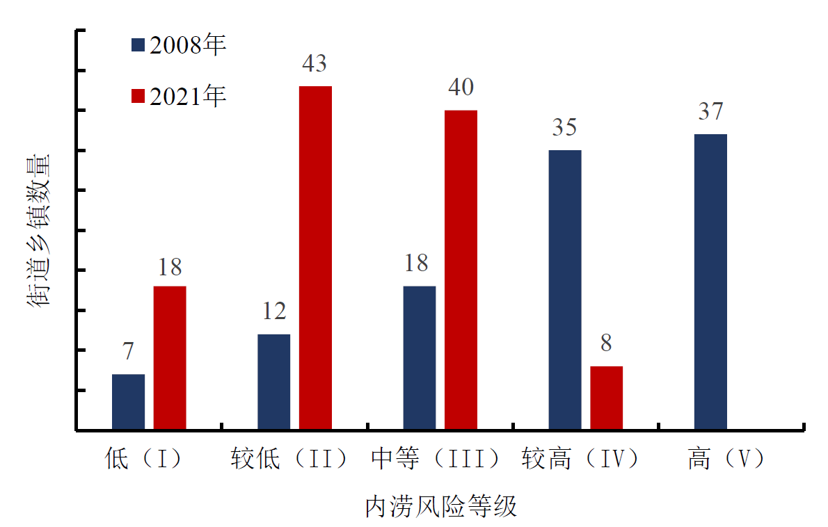
图2 2008-2021年不同内涝风险等级街道乡镇数变化
Figure 2 Changes in the number of sub-districts and townships at different flooding risk levels from 2008 to 2021
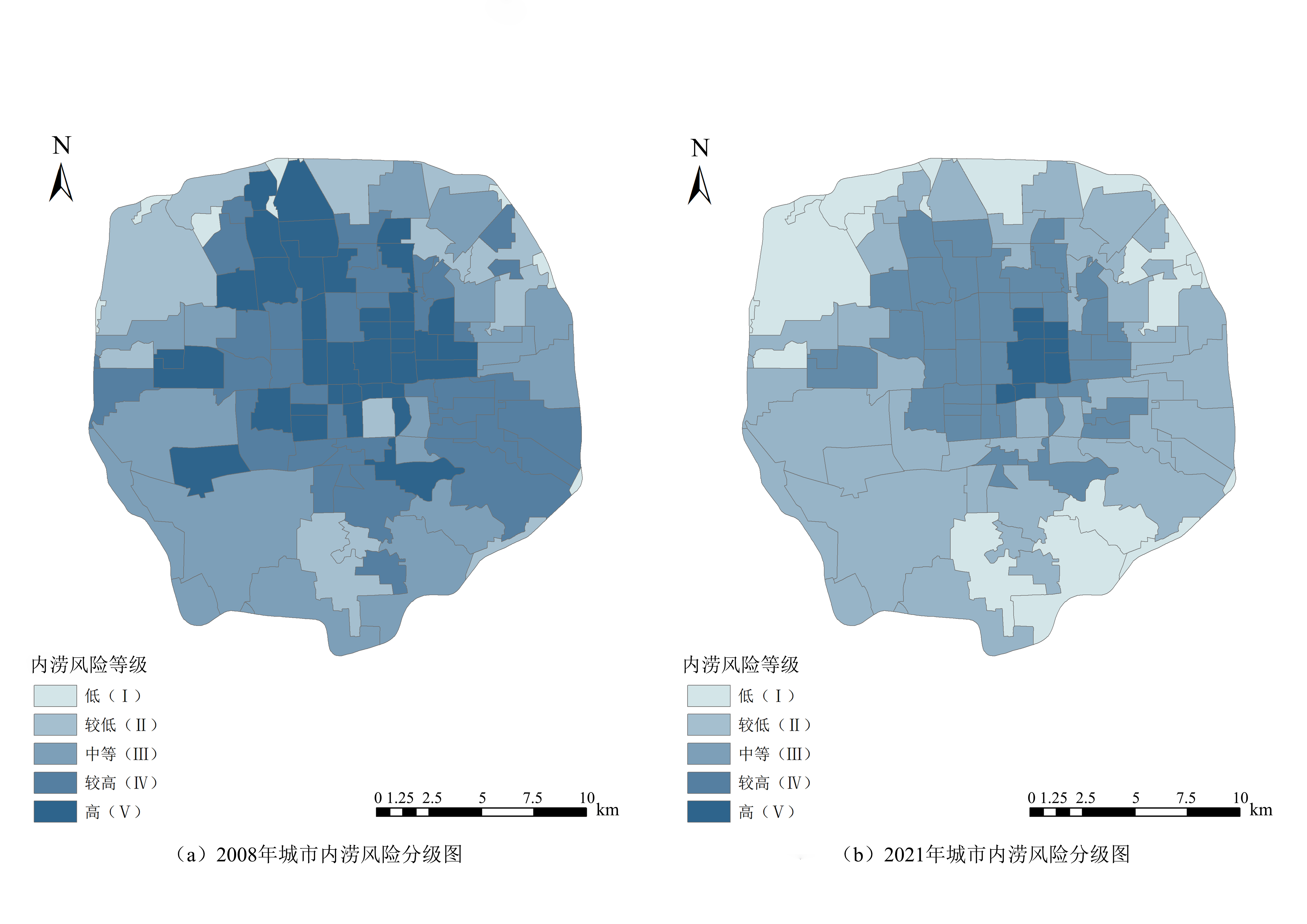
图3 2008年与2021年城市内涝风险等级空间分布图
Figure 3 Spatial distribution of urban flooding risk levels in 2008 and 2021
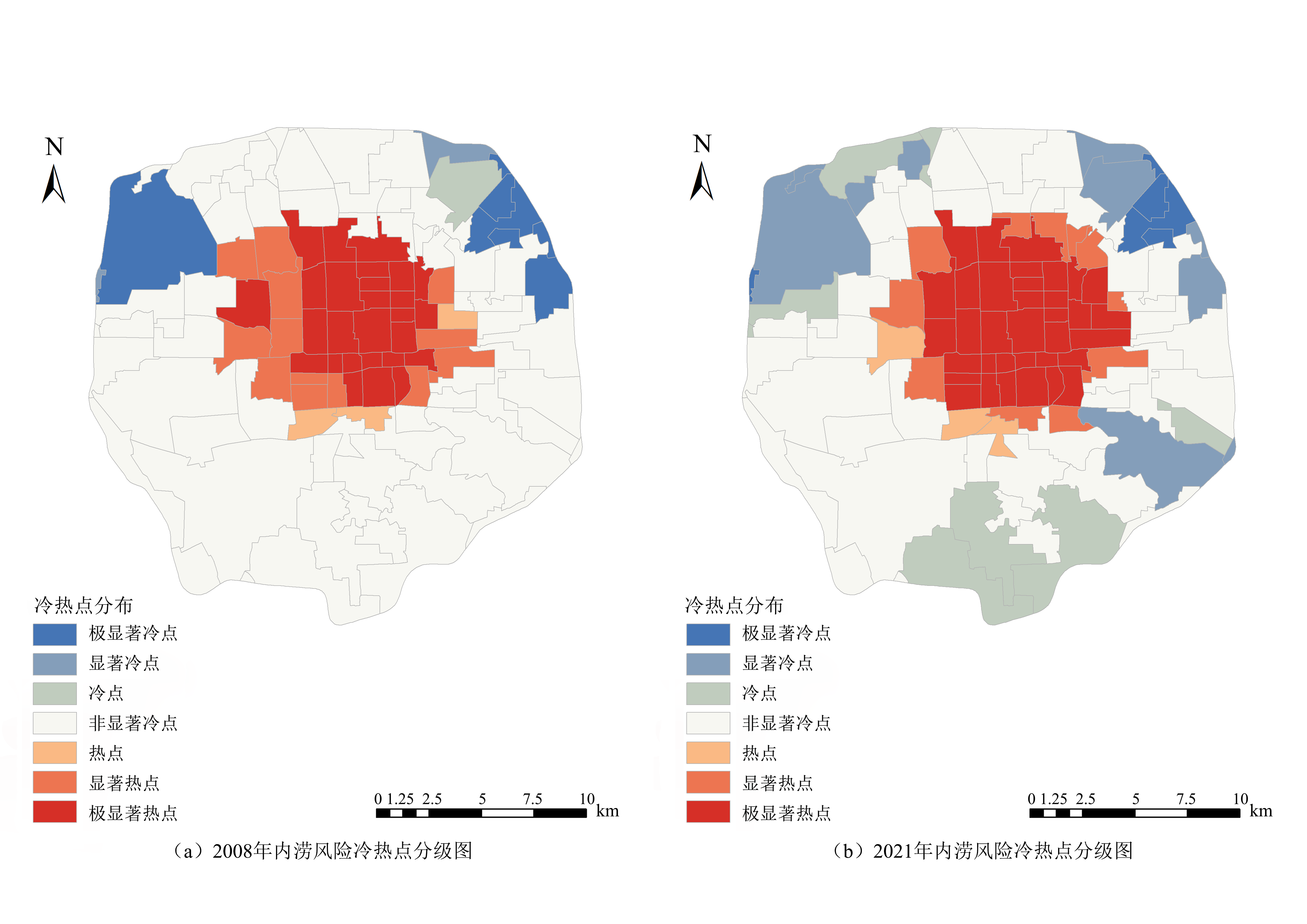
图4 2008年与2021年城市内涝风险冷热点空间分布图
Figure 4 Spatial distribution of urban flooding risk hotspots and coldspots in 2008 and 2021
| 风险等级 | 高(V) | 较高(IV) | 中等(III) | 较低(II) | 低(I) |
|---|---|---|---|---|---|
| 风险值 | >0.091 | 0.057-0.090 | 0.035-0.056 | 0.016- 0.034 | <0.015 |
表4 夏季高温风险分级阈值表
Table 4 Thresholds for Summer High Temperature Risk Classification
| 风险等级 | 高(V) | 较高(IV) | 中等(III) | 较低(II) | 低(I) |
|---|---|---|---|---|---|
| 风险值 | >0.091 | 0.057-0.090 | 0.035-0.056 | 0.016- 0.034 | <0.015 |
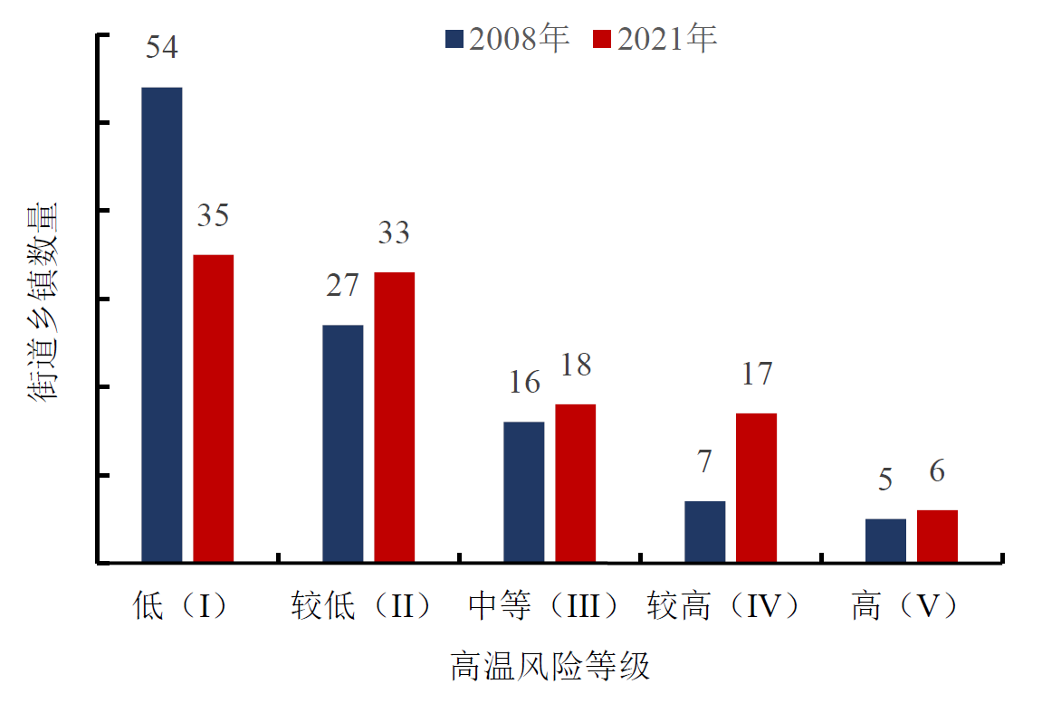
图5 2008-2021年不同夏季高温风险等级街道乡镇数变化
Figure 5 Changes in the number of sub-districts and townships at different risk levels of summer high temperature from 2008 to 2021

图6 2008年与2021年夏季高温风险等级空间分布图
Figure 6 Spatial distribution of summer high temperature risk levels in 2008 and 2021
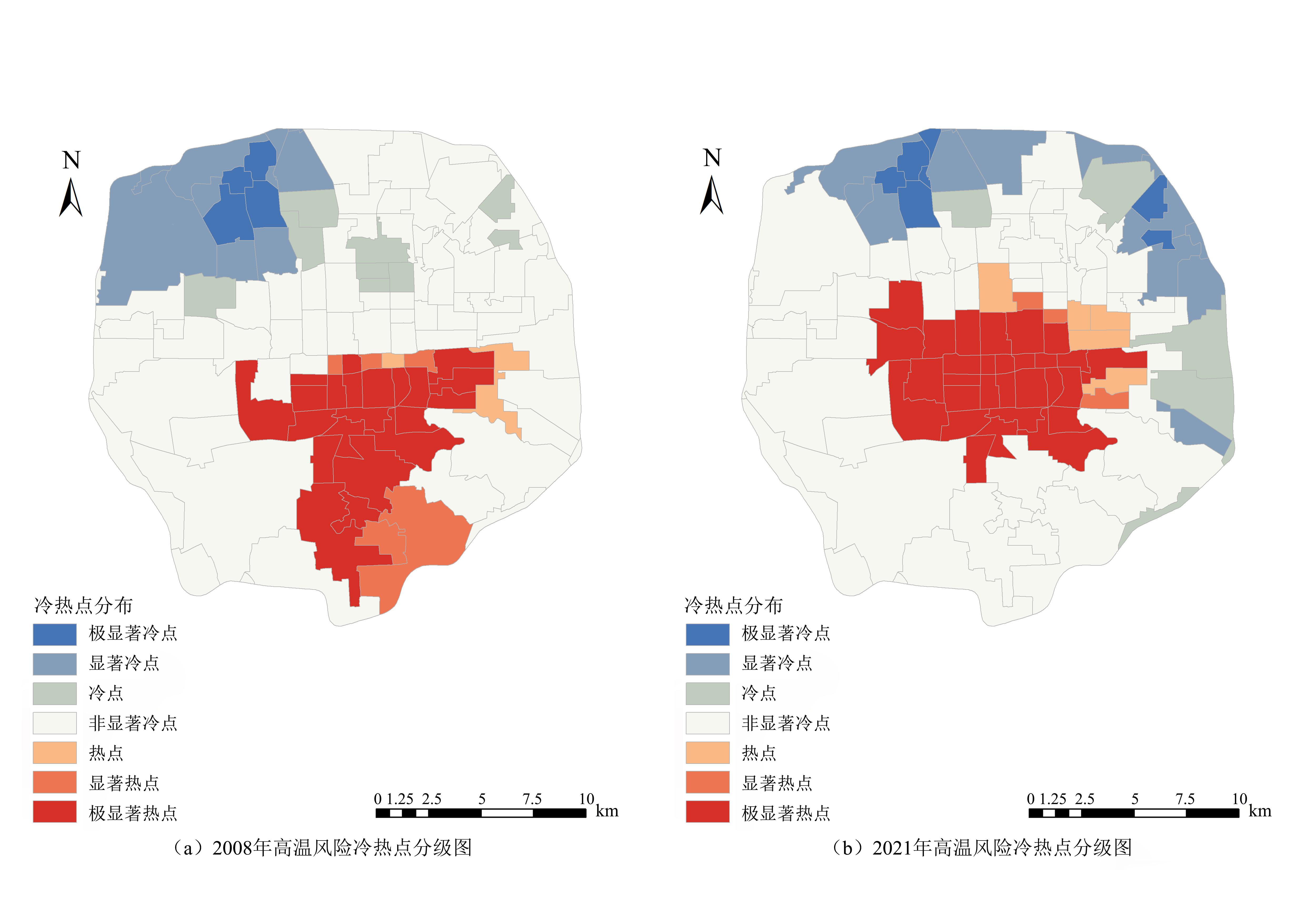
图7 2008年与2021年夏季高温风险冷热点空间分布图
Figure 7 Spatial distribution of summer high temperature risk hotspots and coldspots in 2008 and 2021
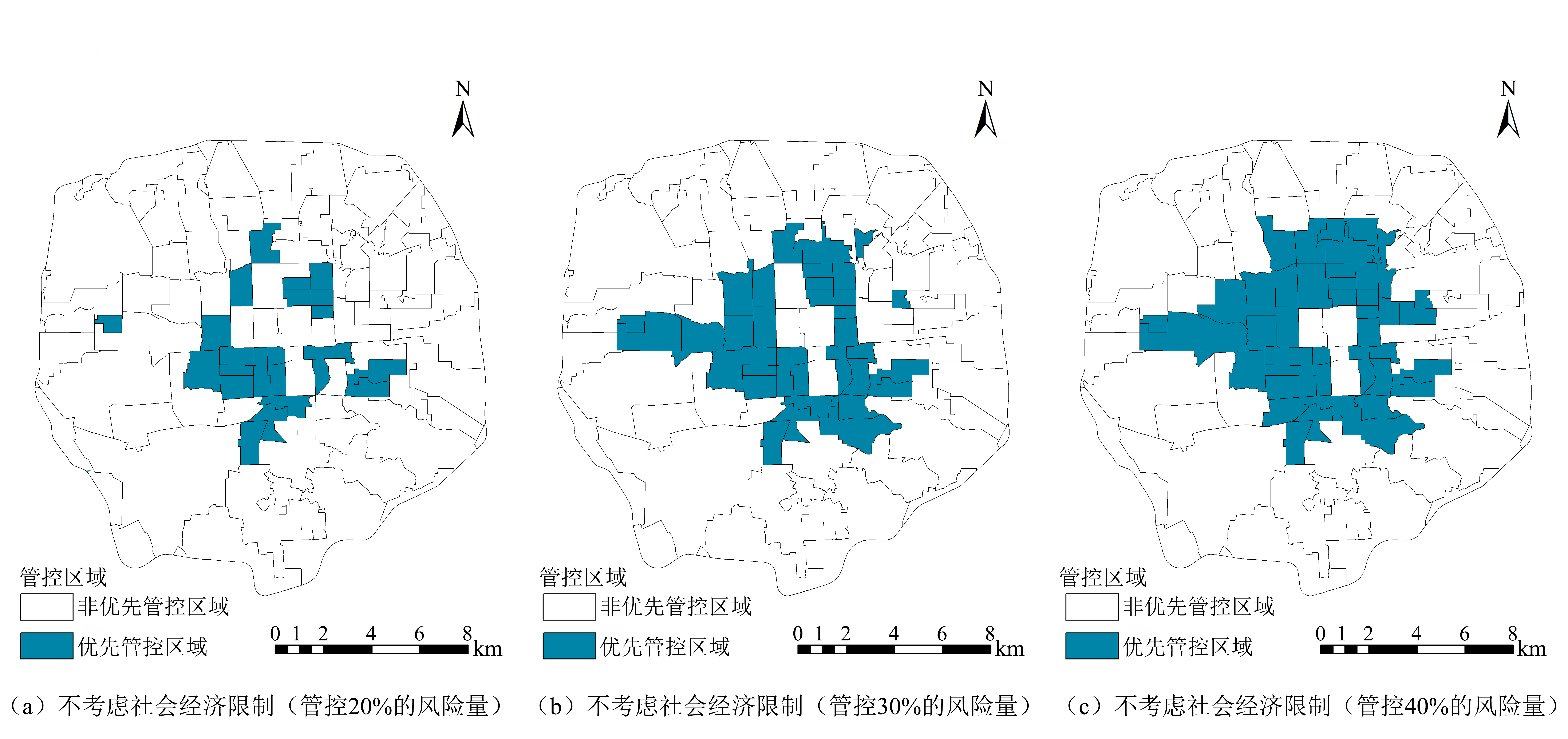
图8 生态风险优先管控区分布(不考虑社会经济因素)
Figure 8 Spatial distribution of priority control areas of ecological risk (without considering socioeconomic factors)

图9 生态风险优先管控识别结果(考虑社会经济因素)
Figure 9 Spatial distribution of priority control areas of ecological risk (considering socioeconomic factors)
| [1] | FERRIER S, PRESSEY R L, BARRETT T W, 2000. A new predictor of the irreplaceability of areas for achieving a conservation goal, its application to real-world planning, and a research agenda for further refinement[J]. Biological Conservation, 93(3): 303-325. |
| [2] | KINNEY P L, O’NEILL M S, BELL M L, et al., 2008. Approaches for estimating effects of climate change on heat-related deaths: Challenges and opportunities[J]. Environmental Science & Policy, 11(1): 87-96. |
| [3] | LI K, HOU Y, FU Q, et al., 2023. Integrating decision-making preferences into ecosystem service conservation area identification: A case study of water-related ecosystem services in the Dawen River watershed, China[J]. Journal of Environmental Management, 340: 117972. |
| [4] | LIN L J, GAO T, LUO M, et al., 2020. Contribution of urbanization to the changes in extreme climate events in urban agglomerations across China[J]. Science of The Total Environment, 744: 140264. |
| [5] | LIU W, CHEN W P, FENG Q, 2018. Field simulation of urban surfaces runoff and estimation of runoff with experimental curve numbers[J]. Urban Water Journal, 15(5): 418-426. |
| [6] | MARGULES C R, PRESSEY R L, 2000. Systematic conservation planning[J]. Nature, 405(6783): 243-253. |
| [7] | MOILANEN A, 2007. Landscape Zonation, benefit functions and target-based planning: Unifying reserve selection strategies[J]. Biological Conservation, 134(4): 571-579. |
| [8] | PIKESLEY S K, GODLEY B J, LATHAM H, et al., 2016. Pink sea fans (Eunicella verrucosa) as indicators of the spatial efficacy of marine protected areas in southwest UK coastal waters[J]. Marine Policy, 64: 38-45. |
| [9] |
PUSPARINI W, CAHYANA A, GRANTHAM H S, et al., 2023. A bolder conservation future for Indonesia by prioritising biodiversity, carbon and unique ecosystems in Sulawesi[J]. Scientific Reports, 13(1): 842.
DOI PMID |
| [10] | STANFORD UNIVERSITY, 2021. Natural Capital Project: InVEST Software Platform[EB/OL]. [2021-09-28]. https://naturalcapitalproject.stanford.edu/software/invest. |
| [11] | TOMLINSON C J, CHAPMAN L, THORNES J, et al., 2011. Including the urban heat island in spatial heat health risk assessment strategies: A case study for Birmingham, UK[J]. International Journal of Hearth Geographics, 10(1): 1-14. |
| [12] | VANDERKAM R P D, WIERSMA Y F, KING D J, 2007. Heuristic algorithms vs. linear programs for designing efficient conservation reserve networks: Evaluation of solution optimality and processing time[J]. Biological Conservation, 137(3): 349-358. |
| [13] | WANG C, HOU Y, ZHANG J L, et al., 2023. Assessing the groundwater loss risk in Beijing based on ecosystem service supply and demand and the influencing factors[J]. Science of the Total Environment, 872(19): 162255. |
| [14] | WATTS M E, BALL I R, STEWART R S, et al., 2009. Marxan with zones: Software for optimal conservation based land- and sea-use zoning[J]. Environmental Modelling & Software, 24(12): 1513-1521. |
| [15] | WILLIAMS J R, KANNAN N, WANG X, et al., 2012. Evolution of the SCS runoff curve number method and its application to continuous runoff simulation[J]. Journal of Hydrologic Engineering, 17(11): 1221-1229. |
| [16] |
包微, 黄晓军, 纪王迪, 2024. 关中地区高温脆弱性评估及其时空变化研究[J]. 干旱区地理, 47(11): 1863-1875.
DOI |
|
BAO W, HUANG X J, JI W D, 2024. Evaluation of heat vulnerability and its spatial-temporal variation in Guanzhong area[J]. Arid Land Geography, 47(11): 1863-1875.
DOI |
|
| [17] | 北京市规划与国土资源管理委员会, 北京市质量技术监督局, 2016. 城镇雨水系统规划设计暴雨径流计算标准: DB11/T 969—2016[S]. 北京: 中国标准出版社. |
| Beijing Municipal Commission of Planning and Land Resources Administration, Beijing Municipal Bureau of Quality and Technical Supervision, 2016. Standard of rainstorm runoff calculation for urban storm drainage system planning and design: DB11/T 969—2016[S]. Beijing: Standards Press of China. | |
| [18] | 蔡甜, 王佳, 2021. 排水模型和GIS模糊综合评价在内涝风险评估中的应用[J]. 中国给水排水, 37(11): 117-124. |
| CAI T, WANG J, 2021. Application of drainage model and GIS fuzzy comprehensive evaluation in waterlogging risk assessment[J]. China Water & Wastewater, 37(11): 117-124. | |
| [19] | 陈壬淦, 2021. MIKE FLOOD模型在普宁市城市内涝风险评估中的模拟与应用[J]. 低碳世界, 11(6): 9-11. |
| CHEN R G, 2021. Simulation and application of the MIKE FLOOD model in urban flood risk assessment in Puning City[J]. Low Carbon World, 11(6): 9-11. | |
| [20] | 陈勇, 刘佐东, 熊非凡, 等, 2020. 基于深度学习的城市积涝监控预警系统[J]. 电脑知识与技术, 16(1): 174-175. |
| CHEN Y, LIU Z D, XIONG F F, et al., 2020. Urban flood monitoring and warning system based on deep learning[J]. Computer Knowledge and Technology, 16(1): 174-175. | |
| [21] | 方创琳, 2009. 改革开放30年来中国的城市化与城镇发展[J]. 经济地理, 29(1): 19-25. |
| FANG C L, 2009. The urbanization and urban development in China after the reform and opening-up[J]. Economic Geography, 29(1): 19-25. | |
| [22] | 冯馨丹, 2022. 景观生态学在城市规划和管理中的运用[J]. 智能建筑与智慧城市 (5): 73-75. |
| FENG X D, 2022. Application of landscape ecology in urban planning and management[J]. Intelligent Building & Smart City (5): 73-75. | |
| [23] | 符素华, 王红叶, 王向亮, 等, 2013. 北京地区径流曲线数模型中的径流曲线数[J]. 地理研究, 32(5): 797-807. |
| FU S H, WANG H Y, WANG X L, et al., 2013. The runoff curve number of SCS-CN method in Beijing[J]. Geographical Research, 32(5): 797-807. | |
| [24] |
郭云, 梁晨, 李晓文, 2018. 基于系统保护规划的黄河流域湿地优先保护格局[J]. 应用生态学报, 29(9): 3024-3032.
DOI |
|
GUO Y, LIANG C, LI X W, 2018. Priority conservation pattern of wetlands in the Yellow River basin based on systematic conservation planning[J]. Chinese Journal of Applied Ecology, 29(9): 3024-3032.
DOI |
|
| [25] | 何苗, 徐永明, 李宁, 等. 2017. 基于遥感的北京城市高温热浪风险评估[J]. 生态环境学报, 26(4): 635-642. |
| HE M, XÜ Y M, LI N, et al., 2017. Assessing heat wave risk in Beijing by remote sensing[J]. Ecology and Environmental Sciences, 26(4): 635-642. | |
| [26] | 花利忠, 孙凤琴, 陈娇娜, 等, 2020. 基于Landsat-8影像的沿海城市公园冷岛效应——以厦门为例[J]. 生态学报, 40(22): 8147-8157. |
| HUA L Z, SUN F Q, CHEN J N, et al., 2020. Quantifying the cool-island effects of urban parks using Landsat-8 imagery in a coastal city, Xiamen, China[J]. Acta Ecologica Sinica, 40(22): 8147-8157. | |
| [27] | 江春波, 周琦, 申言霞, 等, 2021. 山区流域洪涝预报水文与水动力耦合模型研究进展[J]. 水利学报, 52(10): 1137-1150. |
| JIANG C B, ZHOU Q, SHEN Y X, et al., 2021. Review on hydrological and hydrodynamic coupling models for flood forecasting in mountains watershed[J]. Journal of Hydraulic Engineering, 52(10): 1137-1150. | |
| [28] |
李鹤, 张平宇, 程叶青, 2008. 脆弱性的概念及其评价方法[J]. 地理科学进展, 27(2): 18-25.
DOI |
|
LI H, ZHANG P Y, CHENG Y Q, 2008. Concepts and assessment methods of vulnerability[J]. Progress in Geography, 27(2): 18-25.
DOI |
|
| [29] | 李家科, 李亚娇, 李怀恩, 2010. 城市地表径流污染负荷计算方法研究[J]. 水资源与水工程学报, 21(2): 5-13. |
| LI J K, LI Y J, LI H E, 2010. Study on the calculation method for urban surface runoff pollution load[J]. Journal of Water Resources & Water Engineering, 21(2): 5-13. | |
| [30] | 李湉湉, 杜艳君, 莫杨, 等, 2014. 基于脆弱性的高温热浪人群健康风险评估研究进展[J]. 环境与健康杂志, 31(6): 547-550. |
| LI T T, DU Y J, MO Y, et al., 2014. Human health risk assessment of heat wave based on vulnerability: A review of recent studies[J]. Journal of Environment and Health, 31(6): 547-550. | |
| [31] |
凌虹, 孙翔, 朱晓东, 等, 2010. 江苏沿海化工快速发展下区域生态风险评价模型研究[J]. 生态环境学报, 19(5): 1138-1142.
DOI |
| LING H, SUN X, ZHU X D, et al., 2010. Establishing an regional ecological risk assessment model for Jiangsu coastal areas under rapid chemical industrialization[J]. Ecology and Environmental Sciences, 19(5): 1138-1142. | |
| [32] | 刘丽君, 张明罡, 2020. 基于系统保护规划的黄土高原木本种子植物保护优先区识别[J]. 山西大学学报(自然科学版), 43(2): 435-441. |
| LIU L J, ZHANG M G, 2020. Identifying the priority aeras for conservation for woody species of loess plateau based on systematic conservation planning[J]. Journal of Shanxi Unversity (Natural Science Edition), 43(2): 435-441. | |
| [33] |
刘勇, 张韶月, 柳林, 等, 2015. 智慧城市视角下城市洪涝模拟研究综述[J]. 地理科学进展, 34(4): 494-504.
DOI |
|
LIU Y, ZHANG S Y, LIU L, et al., 2015. Research on urban flood simulation: a review from the smart city perspective[J]. Progress in Geography, 34(4): 494-504.
DOI |
|
| [34] | 刘耀彬, 李仁东, 宋学锋, 2005. 中国区域城市化与生态环境耦合的关联分析[J]. 地理学报, 60(2): 237-247. |
|
LIU Y L, LI R D, SONG X F, 2005. Grey associative analysis of regional urbanization and eco-environment coupling in China[J]. Acta Geographica Sinica, 60(2): 237-247.
DOI |
|
| [35] | 吕鸿, 吴泽宁, 管新建, 等, 2021. 缺资料城市洪灾损失率函数构建方法及应用[J]. 水科学进展, 32(5): 707-716. |
| LÜ H, WU Z N, GUAN X J, et al., 2021. Construction methods and applications of flood loss rate functions for cities lacking data[J]. Advances in Water Science, 32(5): 707-716. | |
| [36] | 孟凡迪, 周智, 张贵军, 等, 2023. 基于生态系统服务供需与生态恢复力的国土空间生态修复分区——以京津冀为例[J]. 中国生态农业学报(中英文), 31(9): 1496-1510. |
| MENG F D, ZHOU Z, ZHANG G J, et al., 2023. Land space ecological restoration zoning based on ecosystem service supply and demand and ecological resilience: A case study in the Beijing-Tianjin-Hebei region[J]. Chinese Journal of Eco-Agriculture, 31(9): 1496-1510. | |
| [37] | 史雪威, 张路, 张晶晶, 等, 2018. 西南地区生物多样性保护优先格局评估[J]. 生态学杂志, 37(12): 3721-3728. |
| SHI X W, ZHANG L, ZHANG J J, et al., 2018. Priority area of biodiversity conservation in Southwest China[J]. Chinese Journal of Ecology, 37(12): 3721-3728. | |
| [38] | 田子阳, 褚俊英, 林永寿, 等, 2022. 西宁市多尺度城市内涝风险评价方法[J]. 水资源保护, 38(5): 72-79, 86. |
| TIAN Z Y, CHU J Y, LIN Y S, et al., 2022. Multi-scale urban waterlogging risk assessment method in Xining City[J]. Water Resources Protection. 38(5): 72-79, 86. | |
| [39] | 王思思, 李畅, 李海燕, 等, 2018. 老城排水系统改造的绿色方略——以美国纽约市为例[J]. 国际城市规划, 33(3): 141-147. |
| WANG S S, LI C, LI H Y, et al., 2018. The green strategy of old city drainage system reconstruction: A case of New York City, The US[J]. Urban Planning International, 33(3): 141-147. | |
| [40] | 王璇, 张伟, 刘方华, 等, 2024. 城市建筑小区内涝风险快速识别与驱动因素分析[J]. 人民长江, 55(5): 23-32. |
| WANG X, ZHANG W, LIU F H, et al., 2024. Rapid identification and driving factor analysis of waterlogging risk in urban building communities[J]. Yangtze River, 55(5): 23-32. | |
| [41] | 王小鲁, 夏小林, 1999. 优化城市规模推动经济增长[J]. 经济研究, 34(9): 22-29. |
| WANG X L, XIA X L, 1999. Optimizing urban scale and promoting economic growth[J]. Economic Research Journal, 34(9): 22-29. | |
| [42] |
吴健生, 张朴华, 2017. 城市景观格局对城市内涝的影响研究——以深圳市为例[J]. 地理学报, 72(3): 444-456.
DOI |
| WU J S, ZHANG P H, 2017. The effect of urban landscape patten on urban waterlogging[J]. Acta Geographica Sinica, 72(3): 444-456. | |
| [43] |
薛倩, 谢苗苗, 郭强, 等, 2020. 地理学视角下城市高温热浪脆弱性评估研究进展[J]. 地理科学进展, 39(4): 685-694.
DOI |
|
XUE Q, XIE M M, GUO Q, et al., 2020. Research progress on urban heat wave vulnerability assessment: A geographical perspective[J]. Progress in Geography, 39(4): 685-694.
DOI |
|
| [44] |
张会, 李铖, 程炯, 等, 2019. 基于 “H-E-V” 框架的城市洪涝风险评估研究进展[J]. 地理科学进展, 38(2): 175-190.
DOI |
|
ZHANG H, LI C, CHENG J, et al., 2019. A review of urban flood risk assessment based on the framework of hazard-exposure-vulnerability[J]. Progress in Geography, 38(2): 175-190.
DOI |
|
| [45] | 张彪, 王硕, 李娜, 2015. 北京市六环内绿色空间滞蓄雨水径流功能的变化评估[J]. 自然资源学报, 30(9): 1461-1471. |
|
ZHANG B, WANG S, LI N, 2015. Assessment on the rainwater runoff detention produced by urban green spaces within the 6th ring road of Beijing[J]. Journal of Natural Resources, 30(9): 1461-1471.
DOI |
|
| [46] | 周广胜, 何奇瑾, 2016. 城市内涝防治需充分预估气候变化的影响[J]. 生态学报, 36(16): 4961-4964. |
| ZHOU G S, HE Q J, 2016. Urban flood prevention requires comprehensive assessment of climate change impacts[J]. Acta Ecologica Sinica, 36(16): 4961-4964. | |
| [47] | 周倩倩, 王和平, 许苗苗, 等, 2015. 基于GIS的栅格水文建模法快速评估内涝风险[J]. 中国给水排水, 31(21): 109-113. |
| ZHOU Q Q, WANG H P, XU M M, et al., 2015. A simplified GIS-based hydrological modeling approach for rapid flood risk assessment[J]. China Water & Wastewater, 31(21): 109-113. |
| [1] | 郭铭彬, 龚建周, 王丽娟, 王时宽. 2019-2023年粤港澳大湾区NO2浓度变化的自然主控因子解析[J]. 生态环境学报, 2025, 34(4): 534-547. |
| [2] | 陈鹏, 马育军, 张梦雅, 陈婉婷, 江晓鹏. 基于kNDVI的广东省植被动态变化分析[J]. 生态环境学报, 2025, 34(4): 499-510. |
| [3] | 蒋存征, 陈安强, 胡万里, 付斌, 朱林立, 刘云娥, 黎明琦, 王炽, 张丹. 异龙湖区浅层地下水NO3−-N浓度时空变化及其来源解析[J]. 生态环境学报, 2025, 34(4): 570-580. |
| [4] | 郭昭, 师芸, 刘铁铭, 张雨欣, 闫永智. 2001-2020年秦岭北麓NPP时空格局及驱动因素分析[J]. 生态环境学报, 2025, 34(3): 401-410. |
| [5] | 赵乐鋆, 王诗瑶, 赵子渝, 洪星, 李夫星, 吴佳仪, 华婧妤. 2008-2022年华北平原七省市AOD时空变化特征及主要影响因素分析[J]. 生态环境学报, 2025, 34(2): 256-267. |
| [6] | 叶俊宏, 刘珍环, 刘子瑜. 珠江三角洲城市群国土空间生态修复分区情景模拟[J]. 生态环境学报, 2025, 34(1): 4-12. |
| [7] | 侯金龙, 马志强, 杨澄, 葛双双, 何迪, 董璠. 京津冀地区植被碳源/汇的时空变化特征及影响因素分析[J]. 生态环境学报, 2024, 33(9): 1329-1338. |
| [8] | 张舒涵, 姜海玲, 于海淋, 冯馨慧. 沈阳现代化都市圈景观生态风险时空演变及驱动力分析[J]. 生态环境学报, 2024, 33(9): 1471-1481. |
| [9] | 李程, 程志鹏, 刘育金, 姚义鸣, 李春雷. 全(多)氟烷基化合物生态风险及其管控政策研究[J]. 生态环境学报, 2024, 33(6): 980-996. |
| [10] | 王捷纯, 邓玉娇, 朱怀卫, 孔蕴淇. 广东省不同生态系统植被NPP时空变化及对气候因子的响应[J]. 生态环境学报, 2024, 33(6): 831-840. |
| [11] | 李彩虹. 基因技术生态风险的伦理治理探析[J]. 生态环境学报, 2024, 33(5): 824-830. |
| [12] | 陈晓辉, 胡喜生. 耦合ER和GWR的福州市生态环境质量的驱动力分析[J]. 生态环境学报, 2024, 33(5): 812-823. |
| [13] | 张淼, 王桂霞, 王昌伟, 贺艳云, 许艳芳, 李琪, 许杨, 张俊骁, 张桂芹. 济南市区黑碳污染变化特征及来源解析[J]. 生态环境学报, 2024, 33(4): 560-572. |
| [14] | 杨非凡, 何浩. 基于“EVI-ESV”伊犁河谷生态环境评估及生态分区构建[J]. 生态环境学报, 2024, 33(4): 655-664. |
| [15] | 闫兴蕊, 龚平, 王小萍, 商立海, 李一农, 毛飞剑, 牛学锐, 张勃. 三江源地区土壤和牧草中的有机氯污染物:分布、来源和生态风险[J]. 生态环境学报, 2024, 33(3): 428-438. |
| 阅读次数 | ||||||
|
全文 |
|
|||||
|
摘要 |
|
|||||