生态环境学报 ›› 2025, Vol. 34 ›› Issue (5): 699-709.DOI: 10.16258/j.cnki.1674-5906.2025.05.004
冯义龙1,2( ), 贺萌3, 李波3, 雷界3, 艾丽皎1,2,*()
收稿日期:2024-10-27
出版日期:2025-05-18
发布日期:2025-05-16
通讯作者:
*艾丽皎。E-mail: 作者简介:冯义龙(1978年生),男,正高级工程师,硕士研究生,研究方向为消落带生态修复、生物多样性保护、城市绿地生态效益等。E-mail: 541640500@qq.com
基金资助:
FENG Yilong1,2(), HE Meng3, LI Bo3, LEI Jie3, AI Lijiao1,2,*()
Received:2024-10-27
Online:2025-05-18
Published:2025-05-16
摘要:
构建城市绿地生态网络是改善城市生态问题的有效手段。以山地城市重庆为例,结合最小成本路径模型和生态网络分析方法,探讨了重庆主城区生态网络的特征与优化策略,以期为山地城市生态网络建设提供参考。主要结果如下,1)重庆主城区筛选出39个生态源地,总面积为975 km2,占核心区面积的67%;生态源地主要集中在铜锣山、中梁山等大型绿地斑块。2)利用最小累积阻力模型生成67条潜在生态廊道,总长度156 km,廊道多分布于南北走向的山脉及河谷地带,研究发现地形特征对于生态廊道的分布十分重要。3)Pinchpoint Mapper分析发现,生态夹点集中于大型斑块与小型斑块之间的连接区域,北部源地的生态廊道累积电流量最高,在物种迁徙和生态网络连通性中具有关键作用。4)重庆主城区生态网络的空间分布显著不均,城市内部斑块破碎化程度较高,需加强对生态源地与廊道的保护与优化。该研究可为山地城市生态网络的构建与保护提供数据参考。
中图分类号:
冯义龙, 贺萌, 李波, 雷界, 艾丽皎. 重庆主城区城市生态网络构建与优化[J]. 生态环境学报, 2025, 34(5): 699-709.
FENG Yilong, HE Meng, LI Bo, LEI Jie, AI Lijiao. Construction and Optimization of Urban Ecological Network in Chongqing Main Urban Area[J]. Ecology and Environmental Sciences, 2025, 34(5): 699-709.

图1 研究区位概况 文本所有地图基于地理空间数据云DEM数据及国家地理信息公共服务平台GS(2024)0650号标准地图制作;底图边界无修改
Figure 1 Map of the studied area

图2 不同边缘宽度、邻域结构对MSPA模拟结果的影响 图2a边缘宽度(EdgeWidth):增加边缘宽度将以牺牲核心区域为代价增加非核心区域,并可能改变单个像素的图案类别
Figure 2 Effect of different edge widths and neighbourhood structures on MSPA simulation results
| 阻力因子类别 | 亚类 | 阻力值 |
|---|---|---|
| 土地覆被类型 | 森林 | 1 |
| 草地 | 20 | |
| 耕地 | 50 | |
| 裸地 | 80 | |
| 水域 | 90 | |
| 建设用地 | 100 | |
| 高程 | <450 m | 10 |
| 450-700 | 20 | |
| 700-1000 | 60 | |
| 1000-1400 | 80 | |
| >1400 | 100 | |
| 坡度 | <3° | 1 |
| 3°-8° | 20 | |
| 8°-15° | 60 | |
| 15°-25° | 80 | |
| >25° | 100 | |
| 地形起伏度 | <50 | 10 |
| 50-100 | 40 | |
| 100-200 | 80 | |
| >200 | 100 |
表1 景观阻力面赋值
Table 1 Landscape resistance surface assignment
| 阻力因子类别 | 亚类 | 阻力值 |
|---|---|---|
| 土地覆被类型 | 森林 | 1 |
| 草地 | 20 | |
| 耕地 | 50 | |
| 裸地 | 80 | |
| 水域 | 90 | |
| 建设用地 | 100 | |
| 高程 | <450 m | 10 |
| 450-700 | 20 | |
| 700-1000 | 60 | |
| 1000-1400 | 80 | |
| >1400 | 100 | |
| 坡度 | <3° | 1 |
| 3°-8° | 20 | |
| 8°-15° | 60 | |
| 15°-25° | 80 | |
| >25° | 100 | |
| 地形起伏度 | <50 | 10 |
| 50-100 | 40 | |
| 100-200 | 80 | |
| >200 | 100 |

图3 重庆主城区MSPA景观格局
Figure 3 MSPA landscape pattern in Chongqing main city
| 景观类型 | 面积/km2 | 占生态景观总面积的比例/% |
|---|---|---|
| 核心区 | 1455 | 37 |
| 孤岛 | 168 | 4 |
| 环道 | 159 | 4 |
| 桥接区 | 1775 | 45 |
| 孔隙 | 72 | 2 |
| 边缘区 | 249 | 6 |
| 支线 | 108 | 3 |
表2 基于MSPA景观格局的7类景观数据统计
Table 2 Statistics of the seven landscape categories based on the MSPA landscape pattern
| 景观类型 | 面积/km2 | 占生态景观总面积的比例/% |
|---|---|---|
| 核心区 | 1455 | 37 |
| 孤岛 | 168 | 4 |
| 环道 | 159 | 4 |
| 桥接区 | 1775 | 45 |
| 孔隙 | 72 | 2 |
| 边缘区 | 249 | 6 |
| 支线 | 108 | 3 |
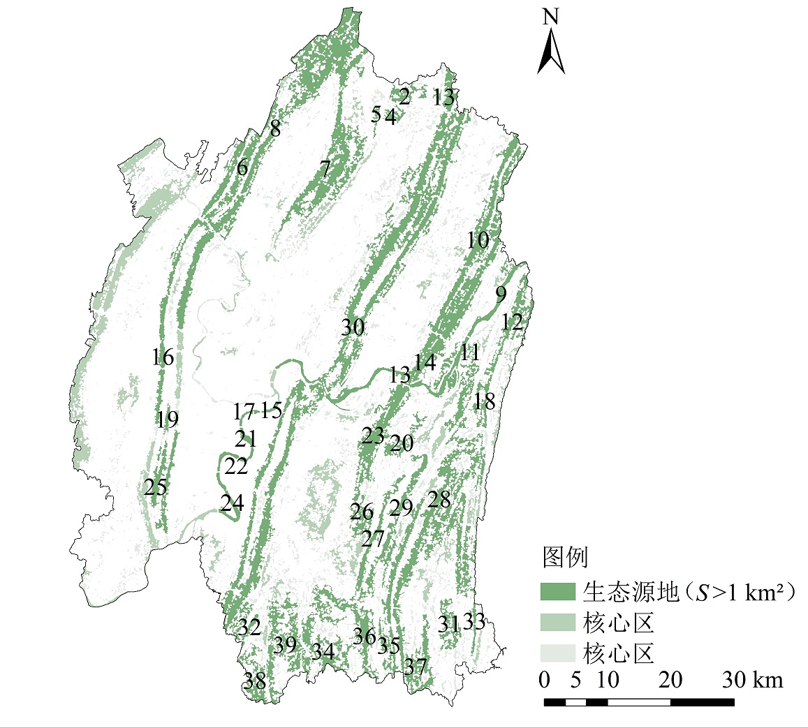
图4 重庆主城区生态源地 图中编号为识别出的源地编号,下同
Figure 4 Ecological sources in the main urban area of Chongqing
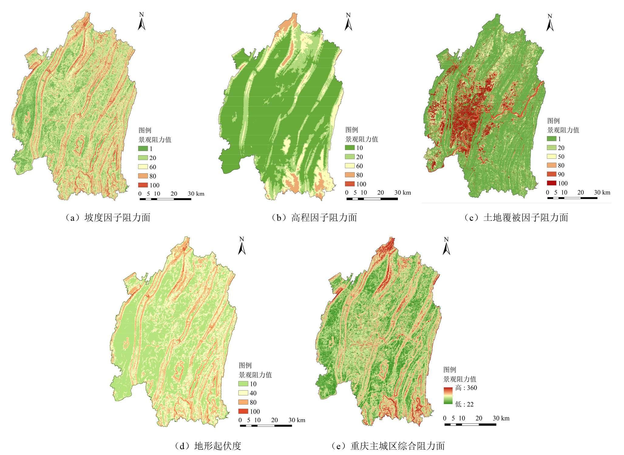
图5 重庆主城区阻力面构建
Figure 5 Resistance surface construction in the main urban area of Chongqing

图6 重庆主城区潜在生态廊道分布 廊道成本加权距离(CWD)与未加权最小成本路径长度(LCPL)的比值反映了物种沿廊道迁移的难易程度,即:最小成本廊道
Figure 6 Distribution of potential ecological corridors in the main urban areas of Chongqing
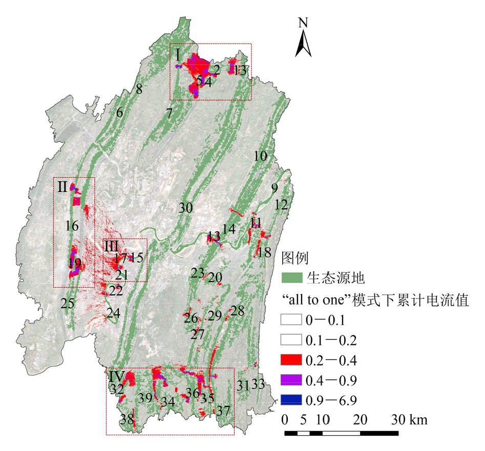
图7 基于电路理论重要生态夹点识别
Figure 7 Identification of important ecological pinch points based on circuit theory

图8 基于电路理论重要生态源识别
Figure 8 Identification of important ecological sources based on circuit theory

图9 重要生态廊道以及部分区域卫星图 左图为右图中红框内对应区域的卫星图
Figure 9 Important ecological corridors and satellite map of selected areas
| [1] | CUI L, WANG J, SUN L, et al., 2020. Construction and optimization of green space ecological networks in urban fringe areas: A case study with the urban fringe area of Tongzhou district in Beijing[J]. Journal of Cleaner Production, 276: 1-10. |
| [2] | DING G Q, YI D, YI J L, et al., 2023. Protecting and constructing ecological corridors for biodiversity conservation: A framework that integrates landscape similarity assessment[J]. Applied Geography, 160: 103098. |
| [3] | LU J, JIAO S, HAN Z W, et al., 2023. Promoting ecological restoration of deeply urbanized hilly areas: A multi-scale ecological networks approach[J]. Ecological Indicators, 154: 110655. |
| [4] | LÜ L, ZHANG S H, ZHU J, et al., 2022. Ecological restoration strategies for mountainous cities based on ecological security patterns and circuit theory: A case of central urban areas in Chongqing, China[J]. International Journal of Environmental Research and Public Health, 19(24): 16505. |
| [5] |
MCRAE B H, DICKSON B G, KEITT T H, et al., 2008. Using circuit theory to model connectivity in ecology, evolution, and conservation[J]. Ecology, 89(10): 2712-2724.
DOI PMID |
| [6] | SHI F N, LIU S L, SUN Y X, et al., 2022. Ecological network construction of the heterogeneous agro-pastoral areas in the upper Yellow River basin[J]. Agriculture, Ecosystems & Environment, 302: 107069. |
| [7] | WEBER T, SLOAN A, WOLF J, 2006. Maryland’s green infrastructure assessment: development of a comprehensive approach to land conservation[J]. Landscape and Urban Planning, 77(1): 94-110. |
| [8] | WANG F, YUAN X Z, ZHOU L L, et al., 2022. Integrating ecosystem services and landscape connectivity to construct and optimize ecological security patterns: A case study in the central urban area Chongqing municipality, China[J]. Environmental Science and Pollution Research International, 29(28): 43138-43154. |
| [9] | ZHOU D, SONG W, 2021. Identifying ecological corridors and networks in mountainous areas[J]. International Journal of Environmental Research and Public Health, 18(9): 4797. |
| [10] | 蔡雨池, 李红, 刘兆顺, 2025. 基于海陆生态安全格局的生态修复关键区域识别——以辽西地区为例[J]. 水土保持研究, 32(1): 285-293. |
| CAI Y C, LI H, LIU Z S, 2025. Identification of key areas of ecological restoration based on ecological security pattern of sea-land: Taking western Liaoning province as an example[J]. Research of Soiland Water Conservation, 32(1): 285-293. | |
| [11] |
陈昕, 彭建, 刘焱序, 等, 2017. 基于 “重要性-敏感性-连通性” 框架的云浮市生态安全格局构建[J]. 地理研究, 36(3): 471-484.
DOI |
| CHEN X, PENG J, LIU Y X, et al., 2017. Constructing ecological security patterns in Yunfu city based on the framework of importance-sensitivity-connectivity[J]. Geographical Research, 36(3): 471-484. | |
| [12] | 高宇, 木皓可, 张云路, 等, 2019. 基于MSPA分析方法的市域尺度绿色网络体系构建路径优化研究——以招远市为例[J]. 生态学报, 39(20): 7547-7556. |
| GAO Y, MU H K, ZHANG Y L, et al., 2019. Research on construction path optimization of urban-scale green network system based on MSPA analysis method: Taking Zhaoyuan City as an example[J]. Acta Ecologica Sinica, 39(20): 7547-7556. | |
| [13] | 李波, 贺萌, 彭琳, 等, 2023. 基于林鸟迁移扩散的重庆市高密度城区生态网络构建研究[J]. 中国园林, 39(7): 35-39. |
| LI B, HE M, PENG L, et al., 2023. Research on the construction of ecological network in the high-density urban area of Chongqing based on the migration and diffusion of forest birds[J]. Chinese Landscape Architecture, 39(7): 35-39. | |
| [14] | 李权荃, 金晓斌, 宋家鹏, 等, 2023a. 基于尺度嵌套与复合功能视角的高强度城市化地区生态网络体系研究——以江阴市为例[J]. 生态学报, 43(22): 9133-9147. |
| LI Q Q, JIN X B, SONG J P, et al., 2023a. Ecological network system of highly urbanized area based on scale nesting and composite function: A case study of Jiangyin City[J]. Acta Ecologica Sinica, 43(22): 9133-9147. | |
| [15] | 李权荃, 金晓斌, 张晓琳, 等, 2023b. 基于景观生态学原理的生态网络构建方法比较与评价[J]. 生态学报, 43(4): 1461-1473. |
| LI Q Q, JIN X B, ZHANG X L, et al., 2023b. Comparison and evaluation of the ecological network construction method based on principles of landscape ecology[J]. Acta Ecologica Sinica, 43(4): 1461-1473. | |
| [16] | 刘玥玮, 秦华, 2010. 城市生态廊道建设探讨[J]. 南方农业, 4(2): 87-89. |
| LIU Y W, QIN H, 2010. Discussion on the construction of urban ecological corridor[J]. South China Agriculture, 4(2): 87-89. | |
| [17] | 倪庆琳, 丁忠义, 侯湖平, 等, 2019. 基于电路理论的生态格局识别与保护研究——以宁武县为例[J]. 干旱区资源与环境, 33(5): 67-73. |
| NI Q L, DING Z Y, HOU H P, et al., 2019. Ecological pattern recognition and protection based on circuit theory[J]. Journal of Arid Land Resources and Environment, 33(5): 67-73. | |
| [18] |
欧定华, 夏建国, 张莉, 等, 2015. 区域生态安全格局规划研究进展及规划技术流程探讨[J]. 生态环境学报, 24(1): 163-173.
DOI |
| OU D H, XIA J G, ZHANG L, et al., 2015. Research progress on regional ecological security pattern planning and discussion of planning technique flow[J]. Ecology and Environmental Sciences, 24(1): 163-173. | |
| [19] | 单楠, 周可新, 潘扬, 等, 2019. 生物多样性保护廊道构建方法研究进展[J]. 生态学报, 39(2): 411-420. |
| SHAN N, ZHOU K X, PAN Y, et al., 2019. Research advances in design methods of biodiversity conservation corridors[J]. Acta Ecologica Sinica, 39(2): 411-420. | |
| [20] |
侍昊, 徐雁南, 2011. 基于景观连通性的城市绿地核心区规划方法研究[J]. 南京林业大学学报(自然科学版), 35(1): 51-56.
DOI |
| SHI H, XU Y N, 2011. Research on planning method of urban green space core region based on landscape connectivity[J]. Journal of Nanjing Forestry University (Natural Sciences Edition), 35(1): 51-56. | |
| [21] | 王永衡, 李春林, 王昊, 等, 2022. 绿色基础设施的生态环境领域研究现状及热点[J]. 生态学报, 42(6): 2510-2521. |
| WANG Y H, LI C L, WANG H, et al., 2022. Current status and hotspots of research in the field of ecological environment of green infrastructure[J]. Acta Ecologica Sinica, 42(6): 2510-2521. | |
| [22] | 吴昌广, 周志翔, 王鹏程, 等, 2009. 基于最小费用模型的景观连接度评价[J]. 应用生态学报, 20(8): 2042-2048. |
| WU C G, ZHOU Z X, WANG P C, et al., 2009. Evaluation of landscape connectivity based on least-cost model[J]. Chinese Journal of Applied Ecology, 20(8): 2042-2048. | |
| [23] | 吴健生, 刘洪萌, 黄秀兰, 等, 2012. 深圳市生态用地景观连通性动态评价[J]. 应用生态学报, 23(9): 2543-2549. |
| WU J S, LIU H M, HUANG X L, et al., 2012. Dynamic evaluation on landscape connectivity of ecological land: A case study of Shenzhen, Guangdong Province of South China[J]. Chinese Journal of Applied Ecology, 23(9): 2543-2549. | |
| [24] | 谢慧玮, 周年兴, 关健, 2014. 江苏省自然遗产地生态网络的构建与优化[J]. 生态学报, 34(22): 6692-6700. |
| XIE H W, ZHOU N X, GUAN J, 2014. The construction and optimization of ecological networks based on natural heritage sites in Jiangsu Province[J]. Acta Ecologica Sinica, 34(22): 6692-6700. | |
| [25] | 姚采云, 安睿, 窦超, 等, 2022. 基于MSPA与MCR模型的三峡库区林地生态网络构建与评价研究[J]. 长江流域资源与环境, 31(9): 1953-1962. |
| YAO C Y, AN R, DOU C, et al., 2022. Research on construction and evaluation of forest land ecological network in Three Gorges Reservoir area based on MSPA and MCR model[J]. Resources and Environment in the Yangtze Basin, 31(9): 1953-1962. | |
| [26] | 尹海伟, 孔繁花, 祈毅, 等, 2011. 湖南省城市群生态网络构建与优化[J]. 生态学报, 31(10): 2863-2874. |
| YIN H W, KONG F H, QI Y, et al., 2011. Developing and optimizing ecological networks in urban agglomeration of Hunan Province, China[J]. Acta Ecologica Sinica, 31(10): 2863-2874. | |
| [27] | 袁兴中, 贾恩睿, 刘杨靖, 等, 2020. 河流生命的回归——基于生物多样性提升的城市河流生态系统修复[J]. 风景园林, 27(8): 29-34. |
| YUAN X Z, JIA E R, LIU Y J, et al., 2020. Return of river life: Restoration of urban river ecosystem based on improvement of biodiversity[J]. Landscape Architecture, 27(8): 29-34. | |
| [28] | 袁钟, 赵牡丹, 刘蕊娟, 2017. 基于最小成本距离与改进引力模型的城市绿地网络构建与优化[J]. 陕西师范大学学报(自然科学版), 45(2): 104-109. |
| YUAN Z, ZHAO M D, LIU R J, 2017. Construction and optimization of urban green space network based on minimum cost distance and improved gravity model[J]. Journal of Shaanxi Normal University (Natural Science Edition), 45(2): 104-109. | |
| [29] | 张瑞, 张青萍, 唐健, 等, 2019. 我国城市绿地生态网络研究现状及发展趋势——基于CiteSpace知识图谱的量化分析[J]. 现代城市研究 (10): 2-11. |
| ZHANG R, ZHANG Q P, TANG J, et al., 2019. Research status and development trend of urban green space ecological network in China: A visualized quantitative study based on CiteSpace[J]. Modern Urban Research (10): 2-11. | |
| [30] | 张晓娟, 周启刚, 黄丽盺, 等, 2018. 重庆市主城区地表温度与植被覆盖指数关系研究[J]. 土壤通报, 49(2): 293-302. |
| ZHANG X J, ZHOU Q G, HUANG L X, et al., 2018. Relationship between land surface temperature and NDVI in main urban areas of Chongqing[J]. Chinese Journal of Soil Science, 49(2): 293-302. | |
| [31] | 周浪, 李明慧, 周启刚, 等, 2021. 基于电路理论的特大山地城市生态安全格局构建——以重庆市都市区为例[J]. 水土保持研究, 28(2): 319-325. |
| ZHOU L, LI M H, ZHOU Q G, et al., 2021. Construction of ecological security pattern in very large mountainous city based on circuit theory: Taking Chongqing metropolitan area as an example[J]. Research of Soil and Water Conservation, 28(2): 319-325. |
| [1] | 张雯, 郑天, 刘永超, 钟捷, 苏杰, 李加林. 基于电路理论的浙江省生态保护修复关键区域识别[J]. 生态环境学报, 2024, 33(9): 1482-1494. |
| [2] | 杨金礼, 吴洋洋, 李思亮, 袁佳, 郭纯子, 杨晓东, 施政华, 谢松池, 罗黄婷, 张翠, 顾雪梅, 罗光杰. 雄安新区“三生空间”耦合协调评估及生态安全格局优化[J]. 生态环境学报, 2024, 33(11): 1816-1826. |
| [3] | 方云皓, 赵丽元, 窦碧莹, 王书贤. 基于MSPA-CIRCUIT的长江中游城市群热环境网络识别与评价研究[J]. 生态环境学报, 2023, 32(7): 1237-1248. |
| [4] | 许静, 廖星凯, 甘崎旭, 周茅先. 基于MSPA与电路理论的黄河流域甘肃段生态安全格局构建[J]. 生态环境学报, 2023, 32(4): 805-813. |
| [5] | 肖瑶, 刘渺渺, 梁冠敏, 胡喜生, 林森, 巫志龙. 基于多尺度情景的闽三角地区林地生态网络构建[J]. 生态环境学报, 2023, 32(10): 1750-1759. |
| [6] | 蔡国俊, 袁桂香, 符辉. 基于文献计量分析的生态网络研究现状和趋势[J]. 生态环境学报, 2022, 31(8): 1690-1699. |
| [7] | 杨贤房, 陈朝, 郑林, 万智巍, 陈永林, 王远东. 稀土矿区不同土地利用类型土壤细菌群落特征及网络分析[J]. 生态环境学报, 2022, 31(4): 793-801. |
| [8] | 韦家怡, 李铖, 吴志峰, 张莉, 吉冬青, 程炯. 粤港澳大湾区生态安全格局及重要生态廊道识别[J]. 生态环境学报, 2022, 31(4): 652-662. |
| [9] | 李平星, 邹露. 基于土地利用变化的生态廊道识别和建设成本研究——以南京东郊地区为例[J]. 生态环境学报, 2022, 31(2): 277-285. |
| [10] | 王宇姝, 盛海彦, 罗莎莎, 胡月明, 余玲玲. 环青海湖4种生境土壤中原核微生物群落结构及分子网络特征[J]. 生态环境学报, 2021, 30(7): 1393-1403. |
| 阅读次数 | ||||||
|
全文 |
|
|||||
|
摘要 |
|
|||||