生态环境学报 ›› 2022, Vol. 31 ›› Issue (2): 277-285.DOI: 10.16258/j.cnki.1674-5906.2022.02.008
李平星1,2,*( ), 邹露1,2
收稿日期:2021-08-13
出版日期:2022-02-18
发布日期:2022-04-14
通讯作者:
*作者简介:李平星(1982年生),男,副研究员,博士,研究方向为区域发展与生态环境效应。E-mail: pxli@niglas.ac.cn
基金资助:
LI Pingxing1,2,*(), ZOU Lu1,2
Received:2021-08-13
Online:2022-02-18
Published:2022-04-14
摘要:
快速城市化和土地利用变化带来景观破碎化、连通性下降等问题,对生物多样性保护和生态网络建设带来严重威胁。保护已有的重要生态空间,并对部分非生态空间进行调整,进而构建连通性较高的生态廊道,是促进生态网络建设和保障区域可持续发展的重要手段。以南京东郊紫金山-青龙山地区为案例,通过最小累积阻力模型模拟潜在生态过程,揭示2000年和2015年两条生态廊道的位置、走向及其变化,分析廊道内土地利用变化格局,从土地利用调整的角度,核算生态廊道建设费用。结果表明,2000年和2015年生态廊道位置和走向变化明显,由紫金山和青龙山两个生态斑块的北部向南部地区转移,耕地、林地向城镇用地转变是导致生态廊道位置和走向变化的主要原因。2000年廊道内城镇用地扩张明显,占用大量耕地和林地,而2015年廊道内水域、林地等生态空间占比较大,土地利用结构较为稳定,更适宜作为当前的优选生态廊道。受建设用地增长等因素影响,从2000—2015年,通过土地利用调整构建连续性生态廊道的成本显著增加,2000年生态廊道的成本增长较2015年生态廊道更为显著,表明2015年生态廊道更适宜作为当前生态廊道构建的空间载体。随着生态廊道宽度的增加,其建设成本显著提高,200 m宽的生态廊道兼具生态保护的适宜性和土地利用调整的经济合理性,可作为生态廊道建设的主要空间范围。研究揭示了区域生态廊道的变化和成因,确定了具有较高适宜性的优选生态廊道,从土地利用调整的视角核算了生态廊道建设的成本,为促进高度城市化地区生态保护和可持续发展提供了参考。
中图分类号:
李平星, 邹露. 基于土地利用变化的生态廊道识别和建设成本研究——以南京东郊地区为例[J]. 生态环境学报, 2022, 31(2): 277-285.
LI Pingxing, ZOU Lu. Identification and Construction Cost of Ecological Corridors Based on Land Use Change: The Case of Eastern Suburb Nanjing[J]. Ecology and Environment, 2022, 31(2): 277-285.
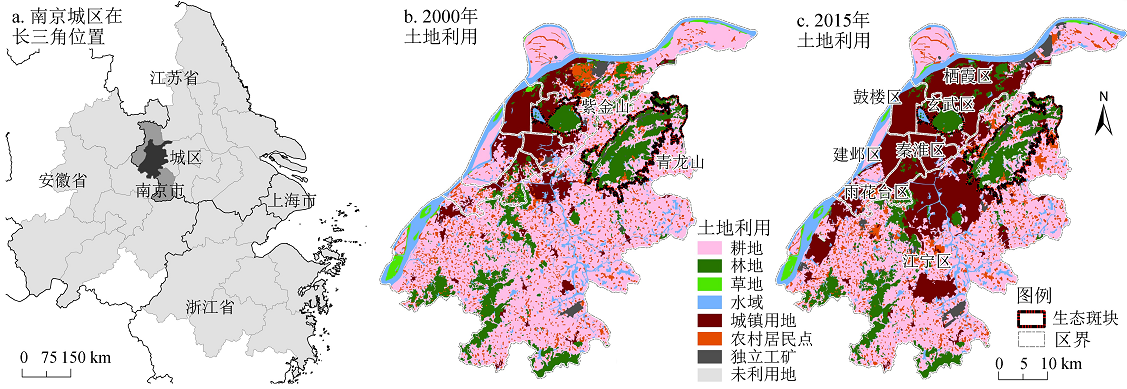
图1 南京城区位置和土地利用
Figure 1 Location and land use of urban Nanjing
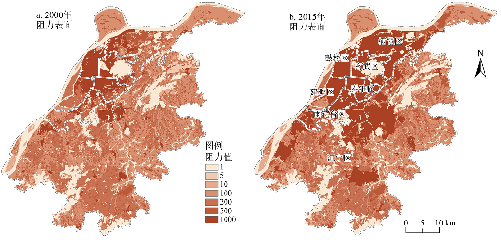
图2 南京城区2000年和2015年阻力表面
Figure 2 Resistance surface of urban Nanjing in 2000 and 2015
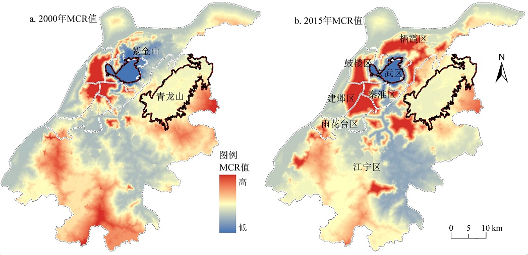
图3 南京城区最小累积阻力分析结果
Figure 3 MCR analysis results of urban Nanjing in 2000 and 2015
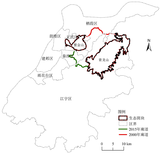
图4 2000年和2015年紫金山-青龙山生态廊道位置
Figure 4 Ecological corridors from Zijin Mt. to Qing Mt. in 2000 and 2015
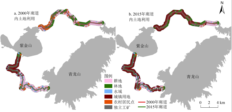
图5 2000年和2015年生态廊道的土地利用结构
Figure 5 Land use of the ecological corridor in 2000 and 2015
| 2015年土地利用 Land use in 2015/hm2 | 2000年土地利用 Land use in 2010/hm2 | |||||||
|---|---|---|---|---|---|---|---|---|
| 耕地 Crop land | 林地 Forest | 水域 Waters | 城镇用地 Urban land | 农村居民点 Rural settlement | 独立工矿 IIML | 2015年小计 2015 total | 2000—2015年土地利用变化 Land use changes | |
| 耕地 Crop land | 384.59 | 0.11 | 0.01 | 0.00 | 0.04 | 0.00 | 384.74 | -936.41 |
| 林地 Forest | 53.83 | 1265.29 | 0.06 | 0.00 | 2.08 | 1.97 | 1323.24 | -330.13 |
| 水域 Waters | 0.01 | 0.00 | 16.65 | 0.00 | 0.00 | 0.00 | 16.66 | -137.41 |
| 城镇用地 Urban land | 882.68 | 333.10 | 137.35 | 4.48 | 580.28 | 30.62 | 1968.52 | 1964.04 |
| 农村居民点 Rural settlement | 0.03 | 0.01 | 0.00 | 0.00 | 30.20 | 0.00 | 30.24 | -589.91 |
| 独立工矿 IIML | 0.00 | 54.86 | 0.00 | 0.00 | 7.55 | 9.56 | 71.97 | 29.82 |
| 2000年小计 2000 total | 1321.15 | 1653.37 | 154.07 | 4.48 | 620.15 | 42.15 | 3795.37 | — |
表1 2000年生态廊道土地利用变化矩阵(2000—2015年)
Table 1 Matrix of land use changes of the 2000 ecological corridor from 2000 to 2015
| 2015年土地利用 Land use in 2015/hm2 | 2000年土地利用 Land use in 2010/hm2 | |||||||
|---|---|---|---|---|---|---|---|---|
| 耕地 Crop land | 林地 Forest | 水域 Waters | 城镇用地 Urban land | 农村居民点 Rural settlement | 独立工矿 IIML | 2015年小计 2015 total | 2000—2015年土地利用变化 Land use changes | |
| 耕地 Crop land | 384.59 | 0.11 | 0.01 | 0.00 | 0.04 | 0.00 | 384.74 | -936.41 |
| 林地 Forest | 53.83 | 1265.29 | 0.06 | 0.00 | 2.08 | 1.97 | 1323.24 | -330.13 |
| 水域 Waters | 0.01 | 0.00 | 16.65 | 0.00 | 0.00 | 0.00 | 16.66 | -137.41 |
| 城镇用地 Urban land | 882.68 | 333.10 | 137.35 | 4.48 | 580.28 | 30.62 | 1968.52 | 1964.04 |
| 农村居民点 Rural settlement | 0.03 | 0.01 | 0.00 | 0.00 | 30.20 | 0.00 | 30.24 | -589.91 |
| 独立工矿 IIML | 0.00 | 54.86 | 0.00 | 0.00 | 7.55 | 9.56 | 71.97 | 29.82 |
| 2000年小计 2000 total | 1321.15 | 1653.37 | 154.07 | 4.48 | 620.15 | 42.15 | 3795.37 | — |
| 2015年土地利用 Land use in 2015/hm2 | 2000年土地利用 Land use in 2000/hm2 | |||||||
|---|---|---|---|---|---|---|---|---|
| 耕地 Crop land | 林地 Forest | 水域 Waters | 城镇用地 Urban land | 农村居民点 Rural settlement | 独立工矿 IIML | 2015年小计 Total in 2015 | 2000—2015年土地利用变化 Land use changes | |
| 耕地 Crop land | 637.92 | 4.01 | 9.99 | 0.00 | 0.09 | 0.00 | 652.02 | -512.53 |
| 林地 Forest | 0.10 | 413.09 | 0.03 | 0.00 | 0.05 | 0.01 | 413.28 | -112.00 |
| 水域 Waters | 0.00 | 0.00 | 940.96 | 0.00 | 0.00 | 0.00 | 940.96 | -51.25 |
| 城镇用地 Urban land | 496.09 | 108.11 | 41.17 | 1012.97 | 83.22 | 1.23 | 1742.80 | 729.83 |
| 农村居民点 Rural settlement | 12.44 | 0.06 | 0.04 | 0.00 | 168.92 | 0.00 | 181.47 | -70.82 |
| 独立工矿 IIML | 17.98 | 0.01 | 0.01 | 0.00 | 0.01 | 4.42 | 22.45 | 16.78 |
| 2000年小计 Total in 2000 | 1164.55 | 525.29 | 992.22 | 1012.97 | 252.29 | 5.67 | 3952.99 | — |
表2 2015年生态廊道土地利用变化矩阵(2000—2015年)
Table 2 Matrix of land use changes of the 2015 ecological corridor from 2000 to 2015
| 2015年土地利用 Land use in 2015/hm2 | 2000年土地利用 Land use in 2000/hm2 | |||||||
|---|---|---|---|---|---|---|---|---|
| 耕地 Crop land | 林地 Forest | 水域 Waters | 城镇用地 Urban land | 农村居民点 Rural settlement | 独立工矿 IIML | 2015年小计 Total in 2015 | 2000—2015年土地利用变化 Land use changes | |
| 耕地 Crop land | 637.92 | 4.01 | 9.99 | 0.00 | 0.09 | 0.00 | 652.02 | -512.53 |
| 林地 Forest | 0.10 | 413.09 | 0.03 | 0.00 | 0.05 | 0.01 | 413.28 | -112.00 |
| 水域 Waters | 0.00 | 0.00 | 940.96 | 0.00 | 0.00 | 0.00 | 940.96 | -51.25 |
| 城镇用地 Urban land | 496.09 | 108.11 | 41.17 | 1012.97 | 83.22 | 1.23 | 1742.80 | 729.83 |
| 农村居民点 Rural settlement | 12.44 | 0.06 | 0.04 | 0.00 | 168.92 | 0.00 | 181.47 | -70.82 |
| 独立工矿 IIML | 17.98 | 0.01 | 0.01 | 0.00 | 0.01 | 4.42 | 22.45 | 16.78 |
| 2000年小计 Total in 2000 | 1164.55 | 525.29 | 992.22 | 1012.97 | 252.29 | 5.67 | 3952.99 | — |
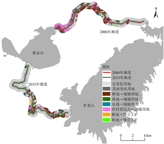
图6 生态廊道内变化用地的类型及其空间分布
Figure 6 Spatial distribution of land use changes of 2000 and 2015 corridors
| 需调整地类 Adjusted land use type | 2000年廊道 2000 corridor (108 Yuan) | 2015年廊道 2015 corridor (108 Yuan) | ||
|---|---|---|---|---|
| 根据2000年用地 Land use in 2000 | 根据2015年用地 Land use in 2015 | 根据2000年用地 Land use in 2000 | 根据2015年用地 Land use in 2015 | |
| 耕地 Crop land | 21.17 | 5.13 | 19.95 | 11.17 |
| 城镇用地 Urban land | 7.31 | 3212.45 | 1653.08 | 2844.10 |
| 农村居民点 Rural settlement | 93.02 | 4.54 | 37.84 | 27.22 |
| 独立工矿 IIML | 6.25 | 10.67 | 0.84 | 3.33 |
| 合计 Total | 127.75 | 3232.79 | 1711.72 | 2885.82 |
表3 2000年和2015年两条生态廊道的总建设费用
Table 3 Total cost of building ecological corridors based on land use in 2000 and 2015
| 需调整地类 Adjusted land use type | 2000年廊道 2000 corridor (108 Yuan) | 2015年廊道 2015 corridor (108 Yuan) | ||
|---|---|---|---|---|
| 根据2000年用地 Land use in 2000 | 根据2015年用地 Land use in 2015 | 根据2000年用地 Land use in 2000 | 根据2015年用地 Land use in 2015 | |
| 耕地 Crop land | 21.17 | 5.13 | 19.95 | 11.17 |
| 城镇用地 Urban land | 7.31 | 3212.45 | 1653.08 | 2844.10 |
| 农村居民点 Rural settlement | 93.02 | 4.54 | 37.84 | 27.22 |
| 独立工矿 IIML | 6.25 | 10.67 | 0.84 | 3.33 |
| 合计 Total | 127.75 | 3232.79 | 1711.72 | 2885.82 |
| 缓冲区 Buffer/m | 耕地 Crop land/(108 Yuan) | 城镇用地 Urban land/(108 Yuan) | 农村居民点 Rural settlement/(108 Yuan) | 独立工矿 IIML/(108 Yuan) | 合计 Total/(108 Yuan) | 占总体廊道建设费用的比例 Proportion of total cost/% |
|---|---|---|---|---|---|---|
| 0‒100 | 0.54 | 58.12 | 0.31 | 0.00 | 58.97 | 2.04 |
| 100‒200 | 1.17 | 172.2 | 1.07 | 0.04 | 174.49 | 6.05 |
| 200‒300 | 1.07 | 211.73 | 1.86 | 0.15 | 214.81 | 7.44 |
| 300‒400 | 1.05 | 250.78 | 2.41 | 0.26 | 254.50 | 8.82 |
| 400‒500 | 1.10 | 295.37 | 3.11 | 0.35 | 299.93 | 10.39 |
| 500‒600 | 1.24 | 329.55 | 3.24 | 0.27 | 334.30 | 11.58 |
| 600‒700 | 1.14 | 338.25 | 3.39 | 0.35 | 343.13 | 11.89 |
| 700‒800 | 1.20 | 350.74 | 3.49 | 0.52 | 355.95 | 12.33 |
| 800‒900 | 1.23 | 383.90 | 3.81 | 0.67 | 389.61 | 13.50 |
| 900‒1000 | 1.43 | 453.46 | 4.53 | 0.71 | 460.13 | 15.94 |
| 全部 Total | 11.17 | 2844.1 | 27.22 | 3.33 | 2885.82 | 100.00 |
表4 2015年生态廊道的建设费用
Table 4 Building cost of 2015 ecological corridors
| 缓冲区 Buffer/m | 耕地 Crop land/(108 Yuan) | 城镇用地 Urban land/(108 Yuan) | 农村居民点 Rural settlement/(108 Yuan) | 独立工矿 IIML/(108 Yuan) | 合计 Total/(108 Yuan) | 占总体廊道建设费用的比例 Proportion of total cost/% |
|---|---|---|---|---|---|---|
| 0‒100 | 0.54 | 58.12 | 0.31 | 0.00 | 58.97 | 2.04 |
| 100‒200 | 1.17 | 172.2 | 1.07 | 0.04 | 174.49 | 6.05 |
| 200‒300 | 1.07 | 211.73 | 1.86 | 0.15 | 214.81 | 7.44 |
| 300‒400 | 1.05 | 250.78 | 2.41 | 0.26 | 254.50 | 8.82 |
| 400‒500 | 1.10 | 295.37 | 3.11 | 0.35 | 299.93 | 10.39 |
| 500‒600 | 1.24 | 329.55 | 3.24 | 0.27 | 334.30 | 11.58 |
| 600‒700 | 1.14 | 338.25 | 3.39 | 0.35 | 343.13 | 11.89 |
| 700‒800 | 1.20 | 350.74 | 3.49 | 0.52 | 355.95 | 12.33 |
| 800‒900 | 1.23 | 383.90 | 3.81 | 0.67 | 389.61 | 13.50 |
| 900‒1000 | 1.43 | 453.46 | 4.53 | 0.71 | 460.13 | 15.94 |
| 全部 Total | 11.17 | 2844.1 | 27.22 | 3.33 | 2885.82 | 100.00 |
| [1] |
ADRIAENSEN F, CHARDON J P, DE BLUST G, et al., 2003. The application of ‘least-cost' modelling as a functional landscape model[J]. Landscape and Urban Planning, 64(4): 233-247.
DOI URL |
| [2] |
KNAPPEN J P, SCHEFFER M, HARMS B, 1992. Estimating habitat isolation in landscape planning[J]. Landscape and Urban Planning, 23(1): 1-16.
DOI URL |
| [3] |
LECHNER A M, SPROD D, CARTER O, et al., 2017. Characterising landscape connectivity for conservation planning using a dispersal guild approach[J]. Landscape Ecology, 32: 99-113.
DOI URL |
| [4] |
LI F, YE Y P, SONG B W, et al., 2015. Evaluation of urban suitable ecological land based on the minimum cumulative resistance model: A case study from Changzhou, China[J]. Ecological Modelling, 318: 194-203.
DOI URL |
| [5] |
LI P X, GAO J L, CHEN J L, 2020. Quantitative assessment of ecological stress of construction lands by quantity and location: case study in Southern Jiangsu, Eastern China[J]. Environment, Development and Sustainability, 22(2): 1559-1578.
DOI URL |
| [6] |
MCRAE B H, DICKSON B G, KEITT T H, et al., 2008. Using circuit theory to model connectivity in ecology, evolution, and conservation[J]. Ecology, 89(10): 2712-2724.
DOI URL |
| [7] |
PENG J, ZHAO H J, LIU Y X, 2017. Urban ecological corridors construction: A review[J]. Acta Ecologica Sinica, 37(1): 23-30.
DOI URL |
| [8] |
PINO J, MARULL J, 2012. Ecological networks: Are they enough for connectivity conservation? A case study in the Barcelona Metropolitan Region (NE Spain)[J]. Land Use Policy, 29(3): 684-690.
DOI URL |
| [9] |
YU K J, 1996. Security patterns and surface model in landscape ecological planning[J]. Landscape and Urban Planning, 36(1): 1-17.
DOI URL |
| [10] | 富伟, 刘世梁, 崔保山, 等, 2009. 景观生态学中生态连接度研究进展[J]. 生态学报, 29(11): 6174-6182. |
| FU W, LLU S L, CUI B S, et al., 2009. A review on ecological connectivity in landscape[J]. Acta Ecologica Sinica, 29(11): 6174-6182. | |
| [11] | 雷金睿, 陈宗铸, 陈毅青, 等, 2020. 1990-2018年海南岛湿地景观格局演变及其驱动力分析[J]. 生态环境学报, 29(1): 59-70. |
| LEI J R, CHEN Z Z, CHEN Y Q, et al., 2020. Landscape pattern changes and driving factors analysis of wetland in Hainan Island during 1990-2018 [J]. Ecology and Environmental Sciences, 29(1): 59-70. | |
| [12] | 李明阳, 王晓俊, 刘米兰, 等, 2011. 基于GIS的野生哺乳动物空间平衡抽样方法研究[J]. 中南林业科技大学学报, 31(1): 98-103. |
| LI M Y, WANG X J, LIU M L, et al., 2011. Spatial balanced sampling for wild mammals based on GIS: A case study of eastern suburbs of Nanjing[J]. Journal of Central South University of Forestry & Technology, 31(1): 98-103. | |
| [13] | 梁健超, 丁志锋, 肖荣波, 等, 2016. 基于物种运动路径识别的动物通道选址: 以武深高速为例[J]. 生态学报, 36(24): 8145-8153. |
| LIANG J C, DING Z F, XIAO R B, et al., 2016. Location design of wildlife corridors based on animal movement path identification: a case study of the Wuhan-Shenzhen Highway[J]. Acta Ecologica Sinica, 36(24): 8145-8153. | |
| [14] | 梁龙武, 王振波, 方创琳, 等, 2019. 京津冀城市群城市化与生态环境时空分异及协同发展格局[J]. 生态学报, 39(4): 1212-1225. |
| LIANG L W, WANG Z B, FANG C L, et al., 2019. Spatiotemporal differentiation and coordinated development pattern of urbanization and the ecological environment of the Beijing-Tianjin-Hebei urban agglomeration[J]. Acta Ecologica Sinica, 39(4): 1212-1225. | |
| [15] | 刘强, 杨众养, 陈毅青, 等, 2021. 基于CA-Markov多情景模拟的海南岛土地利用变化及其生态环境效应[J]. 生态环境学报, 30(7): 1522-1531. |
| LIU Q, YANG Z Y, CHEN Y Q, et al., 2021. Multi-scenario Simulation of Land Use Change and Its Eco-environmental Effect in Hainan Island Based on CA-Markov Model[J]. Ecology and Environmental Sciences, 30(7): 1522-1531. | |
| [16] | 刘米兰, 李明阳, 王晓俊, 等, 2012. 南京东郊生物多样性保护核心绿地分析方法研究[J]. 西南林业大学学报, 32(1): 36-40. |
| LIU M L, LI M Y, WANG X J, et al., 2012. Analysis method of greenspace in the core area for biodiversity conservation in eastern suburbs of Nanjing city[J]. Journal of Southwest Forestry University, 32(1): 36-40. | |
| [17] | 刘世梁, 安南南, 侯笑云, 等, 2018. 澜沧江下游景观破碎化时空动态及成因分析[J]. 生态环境学报, 27(7): 1351-1358. |
| LIU S, AN N, HOU et al., 2018. Spatio-temporal dynamics of landscape fragmentation and its influencing analysis in the downstream of Lancang River Basin[J]. Ecology and Environmental Sciences, 27(7): 1351-1358. | |
| [18] | 刘孝富, 舒俭民, 张林波, 2010. 最小累积阻力模型在城市土地生态适宜性评价中的应用--以厦门为例[J]. 生态学报, 30(2): 421-428. |
| LIU X F, SHU J M, ZHANG L B, 2010. Research on applying minimal cumulative resistance model in urban land ecological suitability assessment: As an example of Xiamen City[J]. Acta Ecologica Sinica, 30(2): 421-428. | |
| [19] | 刘壮壮, 吴未, 刘文锋, 等, 2020. 基于“源地-廊道”生态安全格局构建逻辑范式的建设用地减量化研究[J]. 生态学报, 40(22): 8230-8238. |
| LIU Z Z, WU W, LIU W F, et al., 2020. Study on construction land reduction based on “Source-Corridor” ecological security pattern paradigm[J]. Acta Ecologica Sinica, 40(22): 8230-8238. | |
| [20] | 龙花楼, 刘永强, 李婷婷, 等, 2014. 生态文明建设视角下土地利用规划与环境保护规划的空间衔接研究[J]. 经济地理, 34(5): 1-8. |
|
LONG H L, LIU Y Q, LI T T, et al., 2014. Spatial interlinking of land use planning and environmental protection planning from the perspective of ecological civilization construction[J]. Economic Geography, 34(5): 1-8.
DOI URL |
|
| [21] | 蒙吉军, 王雅, 王晓东, 等, 2016. 基于最小累积阻力模型的贵阳市景观生态安全格局构建[J]. 长江流域资源与环境, 25(7): 1052-1061. |
| MENG J J, WANG Y, WANG X D, et al., 2016. Construction of landscape ecological security pattern in Guiyang based on MCR model[J]. Resources and Environment in the Yangtze Basin, 25(7): 1052-1061. | |
| [22] | 潘竟虎, 刘晓, 2015. 基于空间主成分和最小累积阻力模型的内陆河景观生态安全评价与格局优化--以张掖市甘州区为例[J]. 应用生态学报, 26(10): 3126-2136. |
| PAN J H, LIU X, 2015. Assessment of landscape ecological security and optimization of landscape pattern based on spatial principal component analysis and resistance model in arid inland area: A case study of Ganzhou District, Zhangye City, Northwest China[J]. Chinese Journal of Applied Ecology, 26(10): 3126-2136. | |
| [23] |
彭建, 赵会娟, 刘焱序, 等, 2017. 区域生态安全格局构建研究进展与展望[J]. 地理研究, 36(3): 407-419.
DOI |
| PENG J, ZHAO H J, LIU Y X, et al., 2017. Research progress and prospect on regional ecological security pattern construction[J]. Geographical Research, 36(3): 407-419. | |
| [24] | 苏泳娴, 张虹鸥, 陈修治, 等, 2013. 佛山市高明区生态安全格局和建设用地扩展预案[J]. 生态学报, 33(5): 1524-1534. |
|
SU Y X, ZHANG H O, CHEN X Z, et al., 2013. The ecological security patterns and construction land expansion simulation in Gaoming[J]. Acta Ecologica Sinica, 33(5): 1524-1534.
DOI URL |
|
| [25] | 王军, 顿耀龙, 2015. 土地利用变化对生态系统服务的影响研究综述[J]. 长江流域资源与环境, 24(5): 798-808. |
| WANG J, DUN Y L, 2015. A review on the effects of land use changes on ecosystem services[J]. Resources and Environment in the Yangtze Basin, 24(5): 798-808. | |
| [26] |
王海珍, 张利权, 2005. 基于GIS、景观格局和网络分析法的厦门本岛生态网络规划[J]. 植物生态学报, 2005, 29(1): 144-152.
DOI |
|
WANG H Z, ZHANG L Q, 2005. A GIS, landscape pattern and network analysis based planning of ecological networks for Xiamen island[J]. Chinese Journal of Plant Ecology, 29(1): 144-152.
DOI URL |
|
| [27] | 王玉莹, 金晓斌, 沈春竹, 等, 2019. 东部发达区生态安全格局构建--以苏南地区为例[J]. 生态学报, 39(7): 2298-2310. |
| WANG Y Y, JIN X B, SHEN C Z, et al., 2019. Establishment of an ecological security pattern in the eastern developed regions: A case study of the Sunan District[J]. Acta Ecologica Sinica, 39(7): 2298-2310. | |
| [28] | 魏家星, 宋轶, 王云才, 等, 2019. 基于空间优先级的快速城市化地区绿色基础设施网络构建: 以南京市浦口区为例[J]. 生态学报, 39(4): 1178-1188. |
| WEI J X, SONG Y, WANG Y C, et al., 2019. Urban green infrastructure building for sustainability in areas of rapid urbanization based on evaluating spatial priority: a case study of Pukou in China[J]. Acta Ecologica Sinica, 39(4): 1178-1188. | |
| [29] | 吴昌广, 周志翔, 王鹏程, 等, 2009. 基于最小费用模型的景观连接度评价[J]. 应用生态学报, 20(8): 2042-2048. |
| WU C G, ZHOU Z X, WANG P C, et al., 2009. Evaluation of landscape connectivity based on least-cost model[J]. Chinese Journal of Applied Ecology, 20(8): 2042-2048. | |
| [30] | 吴未, 陈明, 欧名豪, 2018. 建设用地减量化的苏锡常地区土地利用格局优化--基于白鹭生境网络优化视角[J]. 生态学报, 38(14): 5141-5148. |
| WU W, CHEN M, OU M H, 2018. Land-use pattern optimization under the scenario of construction land surface reduction in the Su-Xi-Chang region, from the perspective of Little Egret habitat network optimization[J]. Acta Ecologica Sinica, 38(14): 5141-5148. | |
| [31] |
杨志广, 蒋志云, 郭程轩, 等, 2018. 基于形态空间格局分析和最小累积阻力模型的广州市生态网络构建[J]. 应用生态学报, 29(10): 3367-3376.
PMID |
|
YANG Z G, JIANG Z Y, GUO C X, et al., 2018. Construction of ecological network using morphological spatial pattern analysis and minimal cumulative resistance models in Guangzhou City, China[J]. Chinese Journal of Applied Ecology, 29(10): 3367-3376.
DOI PMID |
|
| [32] | 叶有华, 孙红斌, 林石狮, 等, 2014. 城市自然保护区动物廊道构建技术研究[J]. 生态环境学报, 23(12): 1905-1914. |
| YE Y H, SUN H B, LIN S S, 2014. Researches on Designing Technology of Animal Corridor in Urban Nature Reserve[J]. Ecology and Environmental Sciences, 23(12): 1905-1914. | |
| [33] | 张启舜, 李飞雪, 王帝文, 等, 2021. 基于生态网络的江苏省生态空间连通性变化研究[J]. 生态学报, 41(8): 3007-3020. |
| ZHANG Q S, LI F X, WANG D W, et al., 2021. Analysis on changes of ecological spatial connectivity in Jiangsu Province based on ecological network[J]. Acta Ecologica Sinica, 41(8): 3007-3020. | |
| [34] | 朱强, 俞孔坚, 李迪华, 2005. 景观规划中的生态廊道宽度[J]. 生态学报, 25(9): 2406-2412. |
| ZHU Q, YU K J, LI D H, 2005. The width of ecological corridor in landscape planning[J]. Acta Ecologica Sinica, 25(9): 2406-2412. | |
| [35] | 诸培新, 王敏, 胡军, 2015. 农村土地整治的区域条件与微观农户意愿研究: 以南京市万顷良田工程为例[J]. 南京农业大学学报(社会科学版), 15(1): 61-67. |
| ZHU P X, WANG M, HU J, 2015. Research on regional conditions of rural land remediation and micro-scale farmers' willingness: A case study of 10000-Hectare Fertile farmland project in Nanjing[J]. Journal of Nanjing Agricultural University (Social Sciences Edition), 15(1): 61-67. |
| [1] | 刘霞, 郭澍, 王琳. 区域一体化地区的土地利用与生态服务价值研究——以双莱先行区为例[J]. 生态环境学报, 2023, 32(6): 1163-1172. |
| [2] | 周选博, 王晓丽, 马玉寿, 王彦龙, 罗少辉, 谢乐乐. 返青期休牧措施下高寒草甸主要植物种群的生态位变化特征[J]. 生态环境学报, 2022, 31(8): 1547-1555. |
| [3] | 韦家怡, 李铖, 吴志峰, 张莉, 吉冬青, 程炯. 粤港澳大湾区生态安全格局及重要生态廊道识别[J]. 生态环境学报, 2022, 31(4): 652-662. |
| [4] | 李雅男, 张峰, 赵天启, 郑佳华, 孙宇, 张彬, 赵萌莉. 刈割留茬高度对大针茅草原群落组成及物种生态位的影响[J]. 生态环境学报, 2021, 30(7): 1386-1392. |
| 阅读次数 | ||||||
|
全文 |
|
|||||
|
摘要 |
|
|||||