生态环境学报 ›› 2024, Vol. 33 ›› Issue (9): 1482-1494.DOI: 10.16258/j.cnki.1674-5906.2024.09.015
• 研究论文【环境科学】 •
上一篇
张雯1,2( ), 郑天1, 刘永超1, 钟捷1, 苏杰3, 李加林1,2,*()
收稿日期:2024-04-18
出版日期:2024-09-18
发布日期:2024-10-18
通讯作者:
*李加林。E-mail: lijialin@nbu.edu.cn作者简介:张雯(1989年生),女,工程师,硕士研究生,主要从事自然地理研究。E-mail: 2311110033@nbu.edu.cn
基金资助:
ZHANG Wen1,2(), ZHENG Tian1, LIU Yongchao1, ZHONG Jie1, SU Jie3, LI Jialin1,2,*()
Received:2024-04-18
Online:2024-09-18
Published:2024-10-18
摘要:
科学识别生态保护修复关键区域,因地制宜推进生态管治,可为区域生态安全提供保障。以浙江省为研究区,运用InVEST模型、水量平衡方程、修正通用土壤流失方程、层次分析等方法,以生态系统服务重要性、生态敏感性为评价指标提取生态源地;考虑未来土地格局空间变化的可能性,设置多因素驱动因子,利用PLUS模型的LEAS模块计算每种土地利用类型未来增长的潜在变化概率,并结合多项阻力因子构建综合生态阻力面;最终借助可以有效预测生物种群迁移和扩散过程的电路理论识别生态保护修复关键区域。结果表明,1)浙江省生态源地共65个,面积3.49×10⁴km2,占研究区总面积的33.1%,其中最大源地面积为1.84×10⁴ km2,最小源地面积为20.1 km2。源地类型以林地为主,主要分布于浙西南和浙西北地区。2)生态阻力面高值区主要分布于浙东北平原、浙中盆地、浙东南沿海建成区以及周围耕地,土壤侵蚀度是各类用地发展的主要驱动因子,研究区整体用地发展受制于自然条件。3)提取147条生态廊道,总长度1906 km,平均长度13.0 km,累积成本加权距离4869 km,平均加权距离33.1 km,其中25条高阻廊道和59条低阻廊道是需重点修复、保护的关键廊道,廊道空间异质性特征显著,浙东北地区生态连通性明显较差。4)识别441处生态夹点和90处生态障碍点为需进行生态保护修复的关键节点,面积分别为246、206 km2,其中杭州、绍兴、金华3市夹点占夹点总面积的64.5%,杭州、绍兴、金华、湖州4市障碍点占障碍点总面积的82.4%。综合研究区地形特征和用地现状,提出分区保护修复建议,以期为浙江省生态管治工作提供参考。
中图分类号:
张雯, 郑天, 刘永超, 钟捷, 苏杰, 李加林. 基于电路理论的浙江省生态保护修复关键区域识别[J]. 生态环境学报, 2024, 33(9): 1482-1494.
ZHANG Wen, ZHENG Tian, LIU Yongchao, ZHONG Jie, SU Jie, LI Jialin. Identification of Key Areas for Ecological Protection and Restoration in Zhejiang Province Based on Circuit Theory[J]. Ecology and Environment, 2024, 33(9): 1482-1494.
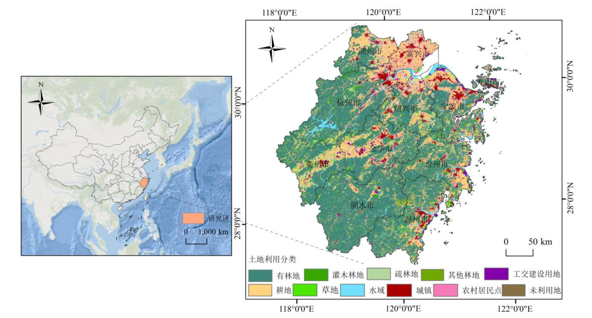
图1 研究区概况图 审图号:GS(2019)1822号,源于自然资源部
Figure 1 Summary map of the study area
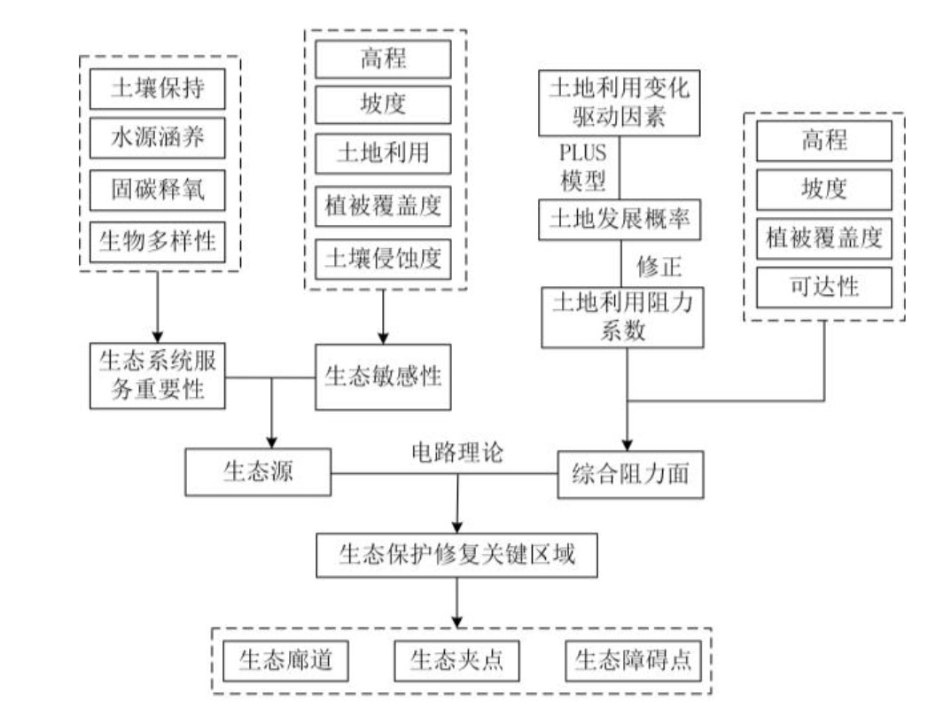
图2 研究区生态保护修复技术路线图
Figure 2 Technical map of ecological conservation and restoration in the study area
| 评价因子 | 敏感性等级 | 权重 | ||||
|---|---|---|---|---|---|---|
| 低 | 较低 | 一般 | 较高 | 高 | ||
| 高程/m | <138 | 138−348 | 348−592 | 592−902 | >902 | 0.111 |
| 坡度/(°) | <7 | 7−16 | 16−25 | 25−34 | >34 | 0.222 |
| 土地利用类型 | 建设用地 | 未利用地 | 耕地、草地 | 水域 | 林地 | 0.167 |
| 植被覆盖度 | <0.280 | 0.280−0.530 | 0.530−0.710 | 0.710−0.850 | >0.850 | 0.167 |
| 土壤侵蚀强度 | 微侵蚀 | 轻度侵蚀 | 中度侵蚀 | 强烈侵蚀 | 极强烈侵蚀 | 0.333 |
表1 生态敏感性评价因子
Table 1 Ecological sensitivity evaluation factors
| 评价因子 | 敏感性等级 | 权重 | ||||
|---|---|---|---|---|---|---|
| 低 | 较低 | 一般 | 较高 | 高 | ||
| 高程/m | <138 | 138−348 | 348−592 | 592−902 | >902 | 0.111 |
| 坡度/(°) | <7 | 7−16 | 16−25 | 25−34 | >34 | 0.222 |
| 土地利用类型 | 建设用地 | 未利用地 | 耕地、草地 | 水域 | 林地 | 0.167 |
| 植被覆盖度 | <0.280 | 0.280−0.530 | 0.530−0.710 | 0.710−0.850 | >0.850 | 0.167 |
| 土壤侵蚀强度 | 微侵蚀 | 轻度侵蚀 | 中度侵蚀 | 强烈侵蚀 | 极强烈侵蚀 | 0.333 |
| 阻力因子 | 相对阻力值 | 权重 | ||||
|---|---|---|---|---|---|---|
| 1 | 3 | 5 | 7 | 9 | ||
| 土地利用修正阻力值 | 由公式 (5) 计算并按自然断点法分类得出 | 0.445 | ||||
| 高程/m | <138 | 138−348 | 348−592 | 592−902 | >902 | 0.052 |
| 坡度/(°) | <7 | 7−16 | 16−25 | 25−34 | >34 | 0.105 |
| 植被覆盖度 | >0.850 | 0.710−0.850 | 0.530−0.710 | 0.280−0.530 | <0.280 | 0.148 |
| 距铁路、高速距离/km | >10 | 5−10 | 2−5 | 1−2 | <1 | 0.125 |
| 距国道、省道距离/km | >5 | 2−5 | 1−2 | 0.5−1 | <0.5 | 0.125 |
表2 生态阻力因子
Table 2 Ecological resistance factors
| 阻力因子 | 相对阻力值 | 权重 | ||||
|---|---|---|---|---|---|---|
| 1 | 3 | 5 | 7 | 9 | ||
| 土地利用修正阻力值 | 由公式 (5) 计算并按自然断点法分类得出 | 0.445 | ||||
| 高程/m | <138 | 138−348 | 348−592 | 592−902 | >902 | 0.052 |
| 坡度/(°) | <7 | 7−16 | 16−25 | 25−34 | >34 | 0.105 |
| 植被覆盖度 | >0.850 | 0.710−0.850 | 0.530−0.710 | 0.280−0.530 | <0.280 | 0.148 |
| 距铁路、高速距离/km | >10 | 5−10 | 2−5 | 1−2 | <1 | 0.125 |
| 距国道、省道距离/km | >5 | 2−5 | 1−2 | 0.5−1 | <0.5 | 0.125 |

图3 浙江省生态系统服务功能空间分布特征
Figure 3 Spatial distribution characteristics of ecosystem services in Zhejiang Province
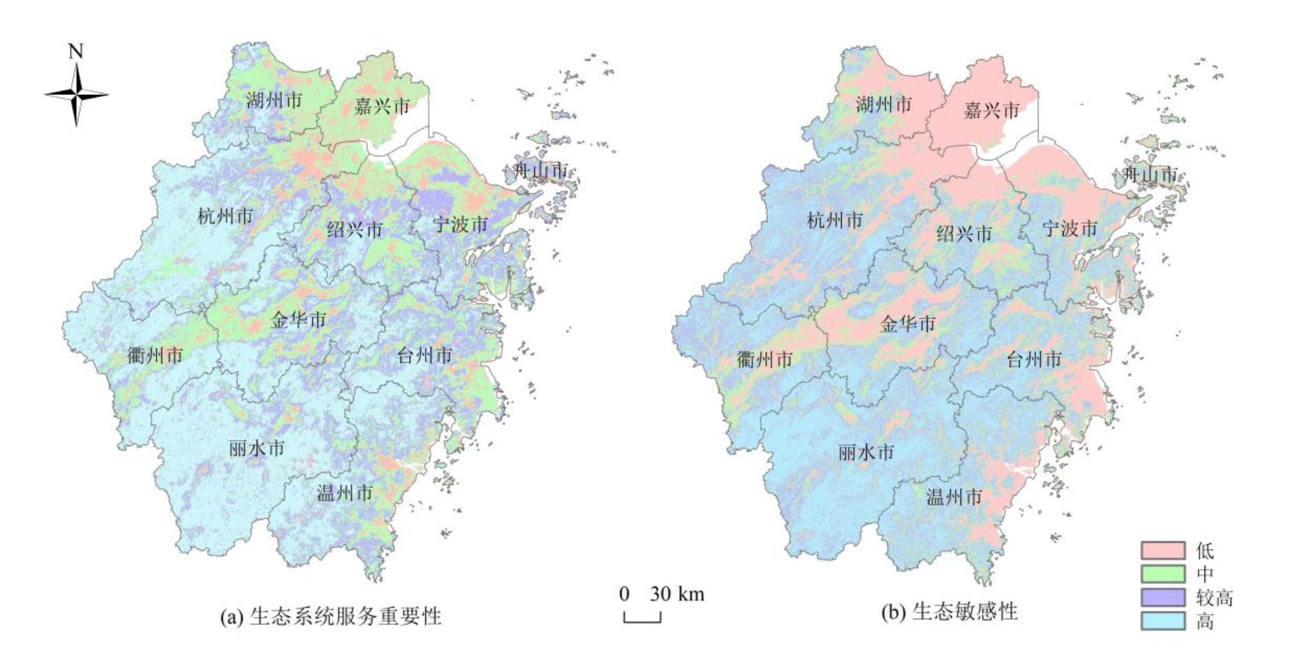
图4 生态系统服务重要性与生态敏感性空间格局
Figure 4 Spatial pattern of ecosystem service importance and ecological sensitivity
| 重要性等级 | 杭州 | 宁波 | 温州 | 嘉兴 | 湖州 | 绍兴 | 金华 | 衢州 | 舟山 | 台州 | 丽水 |
|---|---|---|---|---|---|---|---|---|---|---|---|
| 低 | 1.70×10³ | 1.77×10³ | 1.01×10³ | 1.49×10³ | 832 | 1.08×10³ | 1.10×10³ | 479 | 235 | 874 | 552 |
| 中 | 3.88×10³ | 3.45×10³ | 3.13×10³ | 2.56×10³ | 2.73×10³ | 3.20×10³ | 3.74×10³ | 2.31×10³ | 278 | 3.23×10³ | 1.89×10³ |
| 较高 | 3.58×10³ | 3.11×10³ | 3.47×10³ | 14.7 | 1.24×10³ | 2.76×10³ | 2.74×10³ | 1.55×10³ | 504 | 3.32×10³ | 3.52×10³ |
| 高 | 7.87×10³ | 600 | 3.92×10³ | 0.570 | 1.09×10³ | 1.28×10³ | 3.54×10³ | 4.61×10³ | 96.3 | 2.08×10³ | 1.16×10⁴ |
表3 浙江省分市生态系统重要性等级面积统计
Table 3 Ecological system importance level area statistics of Zhejiang Province km2
| 重要性等级 | 杭州 | 宁波 | 温州 | 嘉兴 | 湖州 | 绍兴 | 金华 | 衢州 | 舟山 | 台州 | 丽水 |
|---|---|---|---|---|---|---|---|---|---|---|---|
| 低 | 1.70×10³ | 1.77×10³ | 1.01×10³ | 1.49×10³ | 832 | 1.08×10³ | 1.10×10³ | 479 | 235 | 874 | 552 |
| 中 | 3.88×10³ | 3.45×10³ | 3.13×10³ | 2.56×10³ | 2.73×10³ | 3.20×10³ | 3.74×10³ | 2.31×10³ | 278 | 3.23×10³ | 1.89×10³ |
| 较高 | 3.58×10³ | 3.11×10³ | 3.47×10³ | 14.7 | 1.24×10³ | 2.76×10³ | 2.74×10³ | 1.55×10³ | 504 | 3.32×10³ | 3.52×10³ |
| 高 | 7.87×10³ | 600 | 3.92×10³ | 0.570 | 1.09×10³ | 1.28×10³ | 3.54×10³ | 4.61×10³ | 96.3 | 2.08×10³ | 1.16×10⁴ |
| 敏感性等级 | 杭州 | 宁波 | 温州 | 嘉兴 | 湖州 | 绍兴 | 金华 | 衢州 | 舟山 | 台州 | 丽水 |
|---|---|---|---|---|---|---|---|---|---|---|---|
| 低 | 4.13×10³ | 4.02×10³ | 2.10×10³ | 4.01×10³ | 3.03×10³ | 2.78×10³ | 3.16 ×10³ | 1.60 ×10³ | 400 | 2.59×10³ | 661 |
| 中 | 3.05×10³ | 2.03×10³ | 2.44×10³ | 53.2 | 1.36×10³ | 2.34×10³ | 2.49 ×10³ | 2.12 ×10³ | 496 | 2.21×10³ | 2.28 ×10³ |
| 较高 | 5.39×10³ | 1.86×10³ | 3.47 ×10³ | 6.45 | 970 | 2.09×10³ | 2.93×10³ | 2.61×10³ | 198 | 2.45×10³ | 5.10×10³ |
| 高 | 4.49×10³ | 1.04×10³ | 3.52×10³ | 0.070 | 539 | 1.12×10³ | 2.57×10³ | 2.62×10³ | 23.9 | 2.26×10³ | 9.49×10³ |
表4 浙江省分市生态敏感性等级面积统计
Table 4 Ecological sensitivity level area statistics of Zhejiang Province km2
| 敏感性等级 | 杭州 | 宁波 | 温州 | 嘉兴 | 湖州 | 绍兴 | 金华 | 衢州 | 舟山 | 台州 | 丽水 |
|---|---|---|---|---|---|---|---|---|---|---|---|
| 低 | 4.13×10³ | 4.02×10³ | 2.10×10³ | 4.01×10³ | 3.03×10³ | 2.78×10³ | 3.16 ×10³ | 1.60 ×10³ | 400 | 2.59×10³ | 661 |
| 中 | 3.05×10³ | 2.03×10³ | 2.44×10³ | 53.2 | 1.36×10³ | 2.34×10³ | 2.49 ×10³ | 2.12 ×10³ | 496 | 2.21×10³ | 2.28 ×10³ |
| 较高 | 5.39×10³ | 1.86×10³ | 3.47 ×10³ | 6.45 | 970 | 2.09×10³ | 2.93×10³ | 2.61×10³ | 198 | 2.45×10³ | 5.10×10³ |
| 高 | 4.49×10³ | 1.04×10³ | 3.52×10³ | 0.070 | 539 | 1.12×10³ | 2.57×10³ | 2.62×10³ | 23.9 | 2.26×10³ | 9.49×10³ |
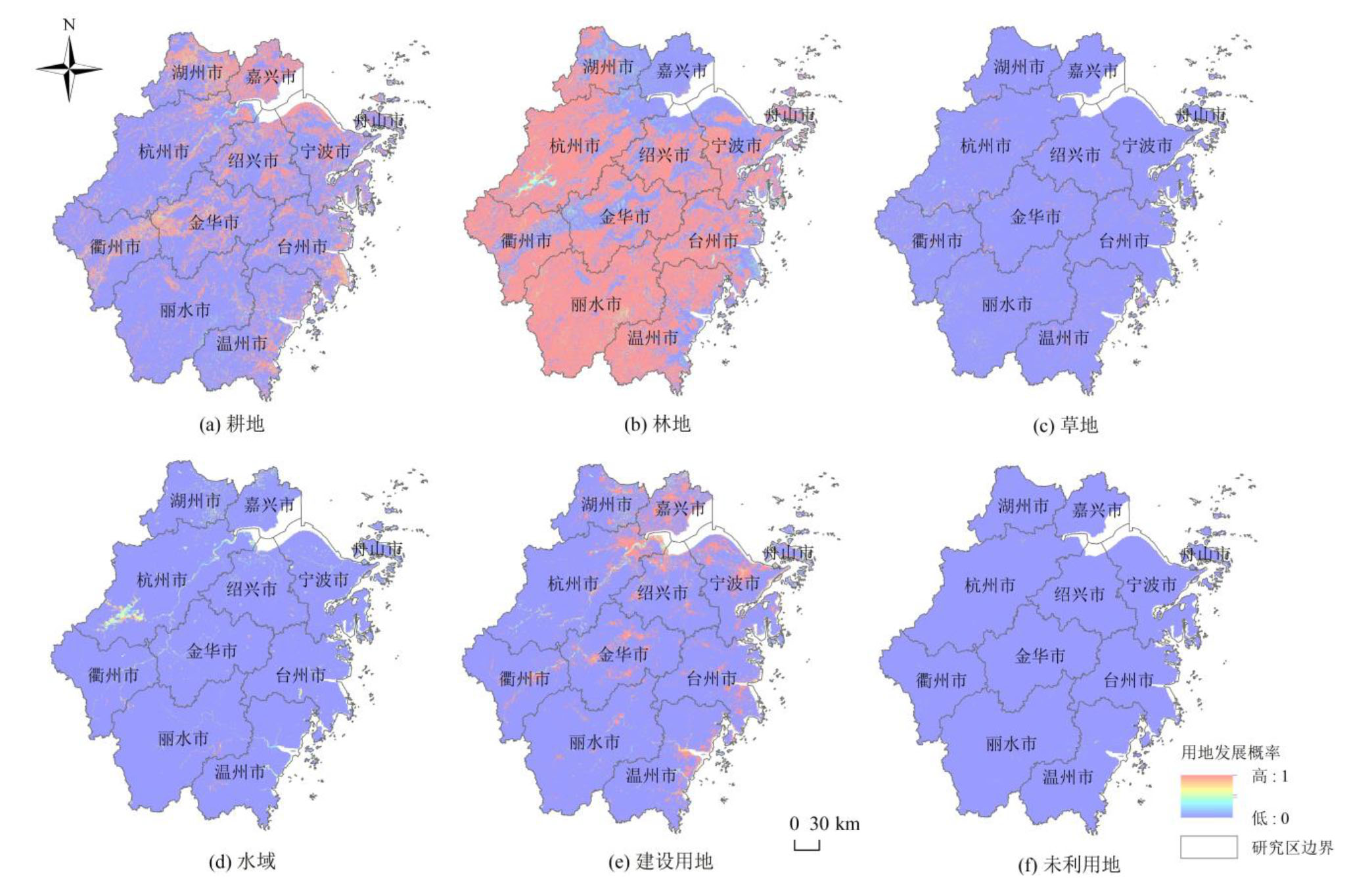
图5 各类用地发展概率
Figure 5 Various types of land use development probability
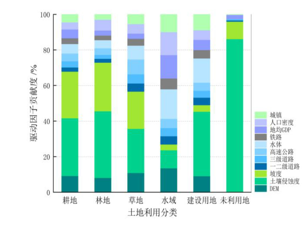
图6 各类用地发展驱动因子贡献度
Figure 6 Contribution degree of driving factors of land use development
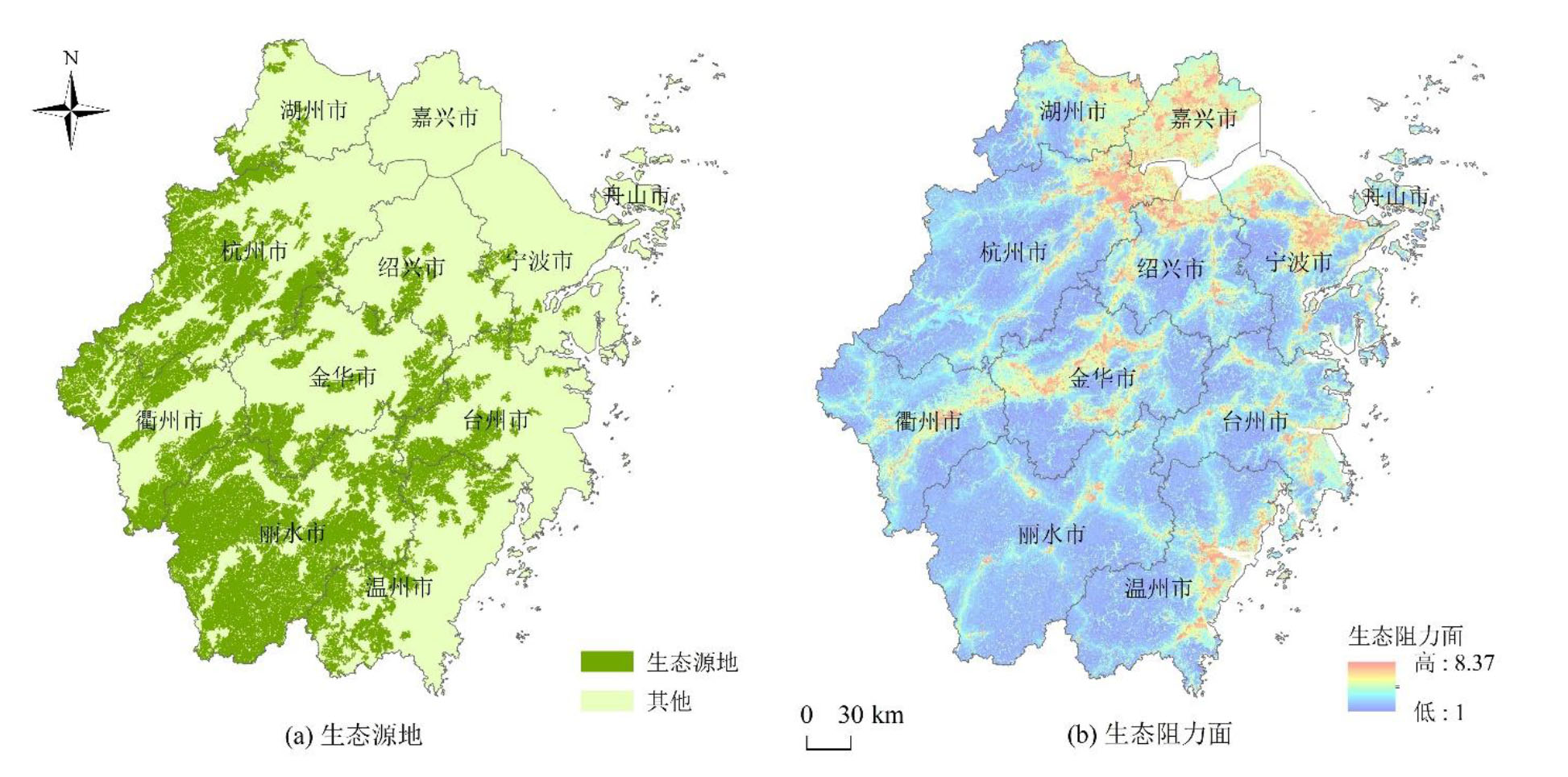
图7 生态源地与生态阻力面
Figure 7 Ecological source and resistance surface
| 生态保护修复区域 | 杭州 | 宁波 | 温州 | 嘉兴 | 湖州 | 绍兴 | 金华 | 衢州 | 舟山 | 台州 | 丽水 |
|---|---|---|---|---|---|---|---|---|---|---|---|
| 生态源地 | 7.15×10³ | 517 | 3.67×10³ | 0.00 | 775 | 1.08×10³ | 3.38×10³ | 4.23×10³ | 0.00 | 2.03×10³ | 1.20×10⁴ |
| 低阻廊道 | 17.0 | 29.9 | 9.00 | 0.00 | 44.4 | 51.0 | 17.2 | 0.18 | 0.00 | 12.3 | 2.88 |
| 中阻廊道 | 83.5 | 26.5 | 21.8 | 0.00 | 19.3 | 80.1 | 89.0 | 15.6 | 0.00 | 52.5 | 4.59 |
| 高阻廊道 | 20.2 | 0.00 | 1.35 | 0.00 | 1.53 | 0.00 | 29.7 | 15.3 | 0.00 | 11.8 | 0.00 |
| 生态夹点 | 64.3 | 3.06 | 26.5 | 0.00 | 9.72 | 47.1 | 47.3 | 27.1 | 0.00 | 20.4 | 0.630 |
| 生态障碍点 | 59.6 | 7.47 | 11.4 | 0.00 | 30.8 | 44.8 | 34.8 | 9.99 | 0.00 | 7.56 | 0.00 |
表5 浙江省分市生态保护修复区域面积统计
Table 5 Statistics of ecological protection and restoration area in Zhejiang Province km2
| 生态保护修复区域 | 杭州 | 宁波 | 温州 | 嘉兴 | 湖州 | 绍兴 | 金华 | 衢州 | 舟山 | 台州 | 丽水 |
|---|---|---|---|---|---|---|---|---|---|---|---|
| 生态源地 | 7.15×10³ | 517 | 3.67×10³ | 0.00 | 775 | 1.08×10³ | 3.38×10³ | 4.23×10³ | 0.00 | 2.03×10³ | 1.20×10⁴ |
| 低阻廊道 | 17.0 | 29.9 | 9.00 | 0.00 | 44.4 | 51.0 | 17.2 | 0.18 | 0.00 | 12.3 | 2.88 |
| 中阻廊道 | 83.5 | 26.5 | 21.8 | 0.00 | 19.3 | 80.1 | 89.0 | 15.6 | 0.00 | 52.5 | 4.59 |
| 高阻廊道 | 20.2 | 0.00 | 1.35 | 0.00 | 1.53 | 0.00 | 29.7 | 15.3 | 0.00 | 11.8 | 0.00 |
| 生态夹点 | 64.3 | 3.06 | 26.5 | 0.00 | 9.72 | 47.1 | 47.3 | 27.1 | 0.00 | 20.4 | 0.630 |
| 生态障碍点 | 59.6 | 7.47 | 11.4 | 0.00 | 30.8 | 44.8 | 34.8 | 9.99 | 0.00 | 7.56 | 0.00 |
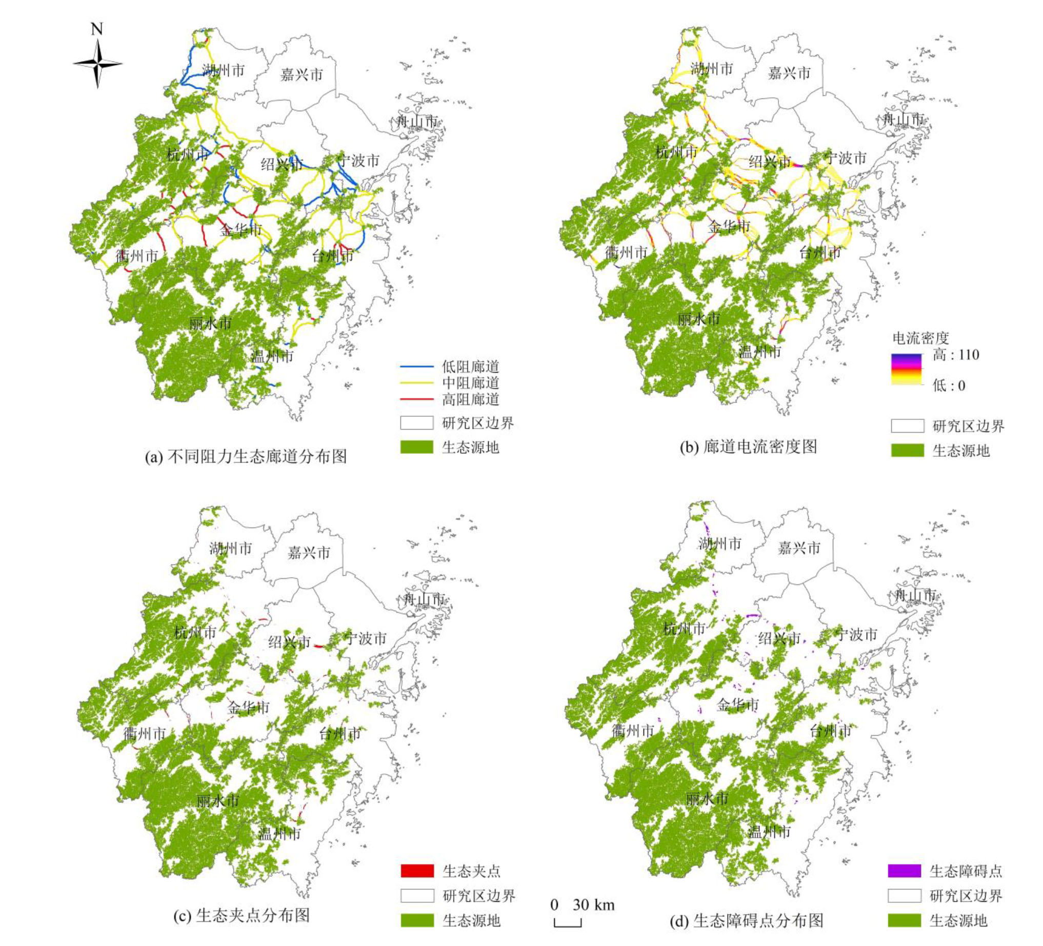
图8 生态保护修复关键区域
Figure 8 Key areas for ecological protection and restoration
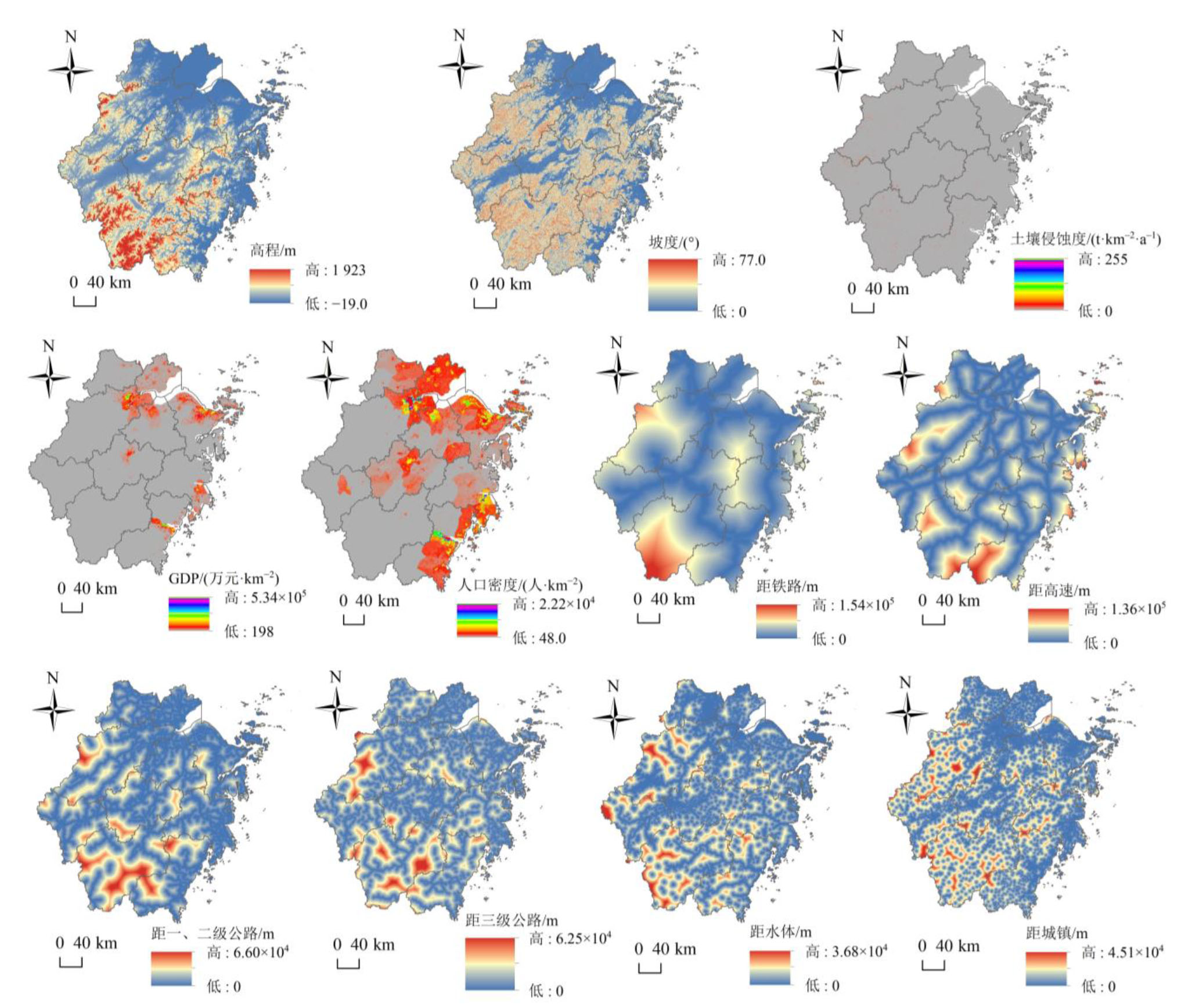
图9 用地发展驱动因子
Figure 9 Driving factors of land use development
| [1] | DICKSON B G, ALBANO C M, ANANTHARAMAN R, et al., 2019. Circuit‐theory applications to connectivity science and conservation[J]. Conservation Biology, 33(2): 239-249. |
| [2] |
FOLEY J A, DEFRIES R, ASNER G P, et al., 2005. Global consequences of land use[J]. Science, 309(5734): 570-574.
DOI PMID |
| [3] | GOLDSTEIN J H, CALDARONE G, DUARTE T K, et al., 2012. Integrating ecosystem-service tradeoffs into land-use decisions[J]. Proceedings of the National Academy of Sciences, 109(19): 7565-7570. |
| [4] | LI C, WU Y M, GAO B P, et al., 2023. Construction of ecological security pattern of national ecological barriers for ecosystem health maintenance[J]. Ecological Indicators, 146: 109801. |
| [5] | LIANG G F, NIU H B, LI Y, 2023. A multi-species approach for protected areas ecological network construction based on landscape connectivity[J]. Global Ecology and Conservation, 46: e02569. |
| [6] | LIANG X, GUAN Q F, CLARKE K C, et al., 2020. Understanding the drivers of sustainable land expansion using a patch- generating land use simulation (PLUS) model: A case study in Wuhan, China[J]. Computers, Environment and Urban Systems, 85: 101569. |
| [7] | MCRAE B H, BEIER P, 2007. Circuit theory predicts gene flow in plant and animal populations[J]. Proceedings of the National Academy of Sciences, 104(50): 19885-19890. |
| [8] | MCRAE B H, DICKSON B G, KEITT T H, et al., 2008. Using circuit theory to model connectivity in ecology, evolution, and conservation[J]. Ecology, 10(89): 2712-2724. |
| [9] | MCRAE B H, 2006. Isolation by resistance[J]. Evolution, 8(60): 1551-1561. |
| [10] | NELSON E, MENDOZA G, REGETZ J, et al., 2009. Modeling multiple ecosystem services, biodiversity conservation, commodity production, and tradeoffs at landscape scales[J]. Frontiers in Ecology and the Environment, 7(1): 4-11. |
| [11] | PENG J, PAN Y J, LIU Y X, et al., 2018. Linking ecological degradation risk to identify ecological security patterns in a rapidly urbanizing landscape[J]. Habitat International, 71: 110-124. |
| [12] | STEFFEN W, RICHARDSON K, ROCKSTRÖM J, et al., 2015. Planetary boundaries: Guiding human development on a changing planet[J]. Science, 347(6223): 1259855. |
| [13] | ZHANG L Q, PENG J, LIU Y X, et al., 2017. Coupling ecosystem services supply and human ecological demand to identify landscape ecological security pattern: A case study in Beijing-Tianjin-Hebei region, China[J]. Urban Ecosystems, 20(3): 701-714. |
| [14] | 曹宇, 王嘉怡, 李国煜, 2019. 国土空间生态修复:概念思辨与理论认知[J]. 中国土地科学, 33(7): 1-10. |
| CAO Y, WANG J Y, LI G Y, 2019. Ecological restoration of territorial space: conceptual speculation and theoretical cognition[J]. Chinese Land Science, 33(7): 1-10. | |
| [15] | 陈思旭, 杨小唤, 肖林林, 等, 2014. 基于RUSLE模型的南方丘陵山区土壤侵蚀研究[J]. 资源科学, 36(6): 1288-1297. |
| CHEN S X, YANG X H, XIAO L L, et al., 2014. Study of soil erosion in the southern hillside area of China based on RUSLE model[J]. Resources Science, 36(6): 1288-1297. | |
| [16] |
陈昕, 彭建, 刘焱序, 等, 2017. 基于 “重要性-敏感性-连通性” 框架的云浮市生态安全格局构建[J]. 地理研究, 36(3): 471-484.
DOI |
| CHEN X, PENG J, LIU Y X, et al., 2017. Constructing ecological security patterns in Yunfu City based on the framework of importance-sensitivity-connectivity[J]. Geographical Research, 36(3): 471-484. | |
| [17] | 陈星, 周成虎, 2005. 生态安全:国内外研究综述[J]. 地理科学进展, 24(6): 8-20. |
| CHEN X, ZHOU C H, 2005. Ecological security: A review of domestic and foreign research[J]. Grogress in Geography, 24(6): 8-20. | |
| [18] | 丁岳, 王柳柱, 桂峰, 等, 2023. 基于InVEST模型和PLUS模型的环杭州湾生态系统碳储量[J]. 环境科学, 44(6): 3343-3352. |
| DING Y, WANG L Z, GUI F, et al., 2023. Ecosystem carbon storage in Hangzhou Bay Area based on InVEST and PLUS models[J]. Environmental Science, 44(6): 3343-3352. | |
| [19] | 杜雨阳, 王征强, 于庆和, 等, 2022. 基于生境质量模型和电路理论的区域生态安全格局构建——以秦岭(陕西段)为例[J]. 农业资源与环境学报, 39(05): 1069-1078. |
| DU Y Y, WANG Z Q, YU Q H, et al., 2022. Construction of regional ecological security pattern based on habitat quality model and circuit theory: A case study of Qinling Mountains (Shaanxi Section)[J]. Journal of Agricultural Resources and Environment, 39(5): 1069-1078. | |
| [20] |
黄苍平, 尹小玲, 黄光庆, 等, 2018. 厦门市同安区生态安全格局构建[J]. 热带地理, 38(6): 874-883.
DOI |
| HUANG C P, YIN X L, HUANG G Q, et al., 2018. Construction of ecological security pattern of Tong'an District, Xiamen City[J]. Tropical Geography, 38(6): 874-883. | |
| [21] |
黄木易, 岳文泽, 冯少茹, 等, 2019. 基于MCR模型的大别山核心区生态安全格局异质性及优化[J]. 自然资源学报, 34(4): 771-784.
DOI |
| HUANG M Y, YUE W Z, FENG S R, et al., 2019. Heterogeneity and optimization of ecological security pattern in the core area of Dabie Mountain based on MCR model[J]. Journal of Natural Resources, 34(4): 771-784. | |
| [22] | 贾良清, 欧阳志云, 赵同谦, 等, 2005. 安徽省生态功能区划研究[J]. 生态学报, 25(2): 254-260. |
| JIA L Q, OUYANG Z Y, ZHAO T Q, et al., 2005. The ecological function regionalization of Anhui Province[J]. Acta Ecologica Sinica, 25(2): 254-260. | |
| [23] |
李涛, 巩雅博, 戈健宅, 等, 2021. 基于电路理论的城市景观生态安全格局构建——以湖南省衡阳市为例[J]. 应用生态学报, 32(7): 2555-2564.
DOI |
|
LI T, GONG Y B, GE J Z, et al., 2021. Construction of urban landscape ecological security pattern based on circuit theory: A case study of Hengyang City, Hunan Province, China[J]. Chinese Journal of Applied Ecology, 32(7): 2555-2564.
DOI |
|
| [24] |
李振亚, 魏伟, 周亮, 等, 2022. 中国陆地生态敏感性时空演变特征[J]. 地理学报, 77(1): 150-163.
DOI |
|
LI Z Y, WEI W, ZHOU L, et al., 2022. Spatio-temporal evolution characteristics of terrestrial ecological sensitivity in China[J]. Acta Geographica Sinica, 77(1): 150-163.
DOI |
|
| [25] | 刘伊萌, 杨赛霓, 倪维, 等, 2020. 生态斑块重要性综合评价方法研究——以四川省为例[J]. 生态学报, 40(11): 3602-3611. |
| LIU Y M, YANG S N, NI W, et al., 2020. Comprehensive assessment method on ecological patch importance: a case study in Sichuan Province, China[J]. Acta Ecologica Sinica, 40(11): 3602-3611. | |
| [26] | 罗雯, 陈佳, 卢瑛莹, 2023. 2000-2020年浙江省陆域生态系统碳库碳储量演变及提升路径[J]. 环境污染与防治, 45(3): 413-418, 426. |
| LUO W, CHEN J, LU Y Y, 2023. Evolution characteristics and improvement path of terrestrial ecosystem carbon storage in Zhejiang Province from 2000 to 2020[J]. Environmental Pollution and Control, 45(3): 413-418, 426. | |
| [27] | 蒙吉军, 王雅, 王晓东, 等, 2016. 基于最小累积阻力模型的贵阳市景观生态安全格局构建[J]. 长江流域资源与环境, 25(7): 1052-1061. |
| MENG J J, WANG Y, WANG X D, et al., 2016. Construction of landscape ecological security pattern in Guiyang based on MCR model[J]. Resources and Environment in the Yangtze Basin, 25(7): 1052-1061. | |
| [28] | 欧阳志云, 崔书红, 郑华, 2015. 我国生态安全面临的挑战与对策[J]. 科学与社会, 5(1): 20-30. |
| OUYANG Z Y, CUI S H, ZHENG H, 2015. The challenges and coping strategies for ensuring ecological security in China[J]. Science and Society, 5(1): 20-30. | |
| [29] | 潘竟虎, 王云, 2021. 基于CVOR和电路理论的讨赖河流域生态安全评价及生态格局优化[J]. 生态学报, 41(7): 2582-2595. |
| PAN J H, WANG Y, 2021. Ecological security evaluation and ecological pattern optimization in Taolai River Basin based on CVOR and circuit theory[J]. Acta Ecologica Sinica, 41(7): 2582-2595. | |
| [30] |
彭建, 李慧蕾, 刘焱序, 等, 2018. 雄安新区生态安全格局识别与优化策略[J]. 地理学报, 73(4): 701-710.
DOI |
|
PENG J, LI H L, LIU Y X, et al., 2018. Identification and optimization of ecological security pattern in Xiong'an New Area[J]. Acta Geographica Sinica, 73(4): 701-710.
DOI |
|
| [31] |
彭建, 赵会娟, 刘焱序, 等, 2017. 区域生态安全格局构建研究进展与展望[J]. 地理研究, 36(3): 407-419.
DOI |
| PENG J, ZHAO H J, LIU Y X, et al., 2017. Research progress and prospect on regional ecological security pattern construction[J]. Geographical Research, 36(3): 407-419. | |
| [32] |
申梦姝, 刘悦忆, 郑航, 等, 2024. 长江流域水源涵养服务价值及其空间转移评估[J]. 长江科学院院报, 41(4): 14-22, 36.
DOI |
| SHEN M S, LIU Y Y, ZHENG H, et al., 2024. Evaluation of water source conservation service value and its spatial transfer in Yangtze River Basin[J]. Journal of Yangtze River Scientific Research Institute, 41(4): 14-22, 36. | |
| [33] | 宋婷, 李岱青, 张林波, 等, 2020. 秦巴山脉区域生态系统服务重要性评价及生态安全格局构建[J]. 中国工程科学, 22(1): 64-72. |
| SONG T, LI D Q, ZHANG L B, et al., 2020. Importance evaluation of ecosystem services and construction of ecological security pattern in Qinba Mountain area[J]. Strategic Study of CAE, 22(1): 64-72. | |
| [34] | 王浩, 马星, 杜勇, 2021. 基于生态系统服务重要性和生态敏感性的广东省生态安全格局构建[J]. 生态学报, 41(5): 1705-1715. |
| WANG H, MA X, DU Y, 2021. Constructing ecological security patterns based on ecological service importance and ecological sensitivity in Guangdong Province[J]. Acta Ecologica Sinica, 41(5): 1705-1715. | |
| [35] | 乌玲瑛, 严力蛟, 2014. 基于GIS和RUSLE模型道路对土壤侵蚀格局的影响研究——以浙江省杭金衢高速诸暨段为例[J]. 生态学报, 34(19): 5659-5669. |
| WU L Y, YAN L J, 2014. Study on the influence of road on soil erosion pattern based on GIS and RUSLE model: A case study of Zhuji Section of Hangjinqu Expressway in Zhejiang Province[J]. Acta Ecologica Sinica, 34(19): 5659-5669. | |
| [36] | 许峰, 尹海伟, 孔繁花, 等, 2015. 基于MSPA与最小路径方法的巴中西部新城生态网络构建[J]. 生态学报, 35(19): 6425-6434. |
| XU F, YIN H W, KONG F H, et al., 2015. Construction of ecological network of new city in western Bazhong City based on MSPA and minimum path method[J]. Acta Ecologica Sinica, 35(19): 6425-6434. | |
| [37] | 岳文泽, 夏皓轩, 吴桐, 等, 2022. 浙江省生境质量时空演变与生态红线评估[J]. 生态学报, 42(15): 6406-6417. |
| YUE W Z, XIA H X, WU T, et al., 2022. Spatio-temporal evolution of habitat quality and ecological red line assessment in Zhejiang Province[J]. Acta Ecologica Sinica, 42(15): 6406-6417. | |
| [38] | 张昌顺, 谢高地, 刘春兰, 等, 2022. 基于水源涵养参照系的中国生态系统水源涵养功能优劣评估[J]. 生态学报, 42(22): 9250-9260. |
| ZHANG C S, XIE G D, LIU C L, et al., 2022. Evaluation of water conservation of China's ecosystems based on benchmark[J]. Acta Ecologica Sinica, 42(22): 9250-9260. | |
| [39] | 张涛, 金德钢, 佟光臣, 等, 2016. 基于RULSE的线状开发建设项目区土壤侵蚀动态监测——以浙江省宁波市北环快速路工程为例[J]. 水土保持通报, 36(5): 131-135. |
| ZHANG T, JIN D G, TONG G C, et al., 2016. Dynamic monitoring of soil erosion in linear development project area based on RULSE: A case study of Beihuan Expressway project in Ningbo City, Zhejiang Province[J]. Bulletin of Soil and Water Conservation, 36(5): 131-135. | |
| [40] | 章文波, 付金生, 2003. 不同类型雨量资料估算降雨侵蚀力[J]. 资源科学, 25(1): 35-41. |
| ZHANG W B, FU J S, 2003. Rainfall erosivity estimation under different types of rainfall data[J]. Resources Science, 25(1): 35-41. | |
| [41] | 朱强, 俞孔坚, 李迪华, 2005. 景观规划中的生态廊道宽度[J]. 生态学报, 25(9): 2406-2412. |
| ZHU Q, YU K J, LI H D, 2005. The width of ecological corridor in landscape planning[J]. Acta Ecologica Sinica, 25(9): 2406-2412. |
| [1] | 唐建亭, 袁杰, 陈宗颜, 李晓燕, 孙子婷. 祁连山南坡土地利用变化及碳储量研究[J]. 生态环境学报, 2024, 33(9): 1353-1361. |
| [2] | 王雯, 侯青青, 裴婷婷. 甘肃河东地区坡度对生态系统服务的影响及其阈值效应[J]. 生态环境学报, 2024, 33(7): 1117-1129. |
| [3] | 方云皓, 赵丽元, 窦碧莹, 王书贤. 基于MSPA-CIRCUIT的长江中游城市群热环境网络识别与评价研究[J]. 生态环境学报, 2023, 32(7): 1237-1248. |
| [4] | 徐梓津, 张雪松, 陈明曼. 山地岩溶区生态系统服务时空演变特征分析——以贵州省为例[J]. 生态环境学报, 2023, 32(7): 1196-1206. |
| [5] | 许静, 廖星凯, 甘崎旭, 周茅先. 基于MSPA与电路理论的黄河流域甘肃段生态安全格局构建[J]. 生态环境学报, 2023, 32(4): 805-813. |
| [6] | 张平江, 党国锋. 基于MCR模型与蚁群算法的洮河流域生态安全格局构建[J]. 生态环境学报, 2023, 32(3): 481-491. |
| [7] | 李语诗, 夏志业, 张蕾. 基于SSPs多情景目标的2030年成渝经济圈土地利用碳排放预测及其空间优化[J]. 生态环境学报, 2023, 32(3): 535-544. |
| [8] | 王成武, 罗俊杰, 唐鸿湖. 基于InVEST模型的太行山沿线地区生态系统碳储量时空分异驱动力分析[J]. 生态环境学报, 2023, 32(2): 215-225. |
| [9] | 陈乐, 卫伟. 西北旱区典型流域土地利用与生境质量的时空演变特征[J]. 生态环境学报, 2022, 31(9): 1909-1918. |
| [10] | 王超越, 郭先华, 郭莉, 白丽芳, 夏利林, 王春博, 李廷真. 基于FLUS-InVEST的西北地区土地利用变化及其对碳储量的影响——以呼包鄂榆城市群为例[J]. 生态环境学报, 2022, 31(8): 1667-1679. |
| 阅读次数 | ||||||
|
全文 |
|
|||||
|
摘要 |
|
|||||