生态环境学报 ›› 2024, Vol. 33 ›› Issue (10): 1648-1660.DOI: 10.16258/j.cnki.1674-5906.2024.10.016
• 研究论文【环境科学】 •
上一篇
高文明( ), 宋芊*(), 张皓翔, 王士如
收稿日期:2024-07-30
出版日期:2024-10-18
发布日期:2024-11-15
通讯作者:
*宋芊。E-mail: 2008990038@qhu.edu.cn作者简介:高文明(1999年生),男,硕士研究生,主要从事生态遥感研究。E-mail: gao1741452965@163.com
基金资助:
GAO Wenming(), SONG Qian*(), ZHANG Haoxiang, WANG Shiru
Received:2024-07-30
Online:2024-10-18
Published:2024-11-15
摘要:
2000-2020年是中国经济社会快速发展的时期,这一时期对生态区的无序扩张造成了极大破坏,为实现高质量、可持续发展,需对其进行保护与修复。精准识别区域生态脆弱性的空间分布及其演变规律,是生态保护和恢复措施精确实施的重要前提和基础。当前对于高原牧区生态脆弱性的研究较为匮乏,并且较少能细致分析某一特定区域当前所处的生态状态和所面临的生态压力。三江源地区是中国重要的生态源地和水源供给地,为探究该地区生态脆弱性空间分布和时空演变规律,基于“敏感性-恢复力-压力度”模型,选取对三江源地区生态具有重要影响力的14个指标,结合主成分分析法和地理探测器,对该地区2000、2010和2020年生态脆弱性进行分析,并揭示其驱动机制。结果表明,1)三江源地区生态脆弱性以轻度、中度和重度为主,三期平均面积占比分别为34.5%、29.9%、28.6%;脆弱性在空间分布特征上表现为“北部高、南部低”的格局,有明显的区域差异性。2)从2000-2020年,三江源地区生态敏感性、恢复力和脆弱性呈“先上升、后下降”的趋势;生态压力度随着经济社会的发展处于持续上升趋势。3)生态脆弱性空间格局相对稳定,具有显著的空间集聚特征,高-高聚集区主要分布在北部地区,低-低聚集区主要分布在植被覆盖率高、降水量大的南部地区。4)年降水量、干燥度、相对湿度和NDVI等是三江源地区生态脆弱性的主要驱动因子,q值分别为0.811、0.705、0.614和0.574。由于不同因子之间具有交互作用,生态脆弱性是多因素综合作用的结果。该研究可为高原牧区生态脆弱性评估提供指标选取依据,并对三江源地区生态保护区域的识别提供参考价值。
中图分类号:
高文明, 宋芊, 张皓翔, 王士如. 三江源区生态脆弱性时空演变及驱动因素分析[J]. 生态环境学报, 2024, 33(10): 1648-1660.
GAO Wenming, SONG Qian, ZHANG Haoxiang, WANG Shiru. Analysis of Spatial and Temporal Changes and Driving Factors of Ecological Vulnerability in Sanjiangyuan Region[J]. Ecology and Environment, 2024, 33(10): 1648-1660.
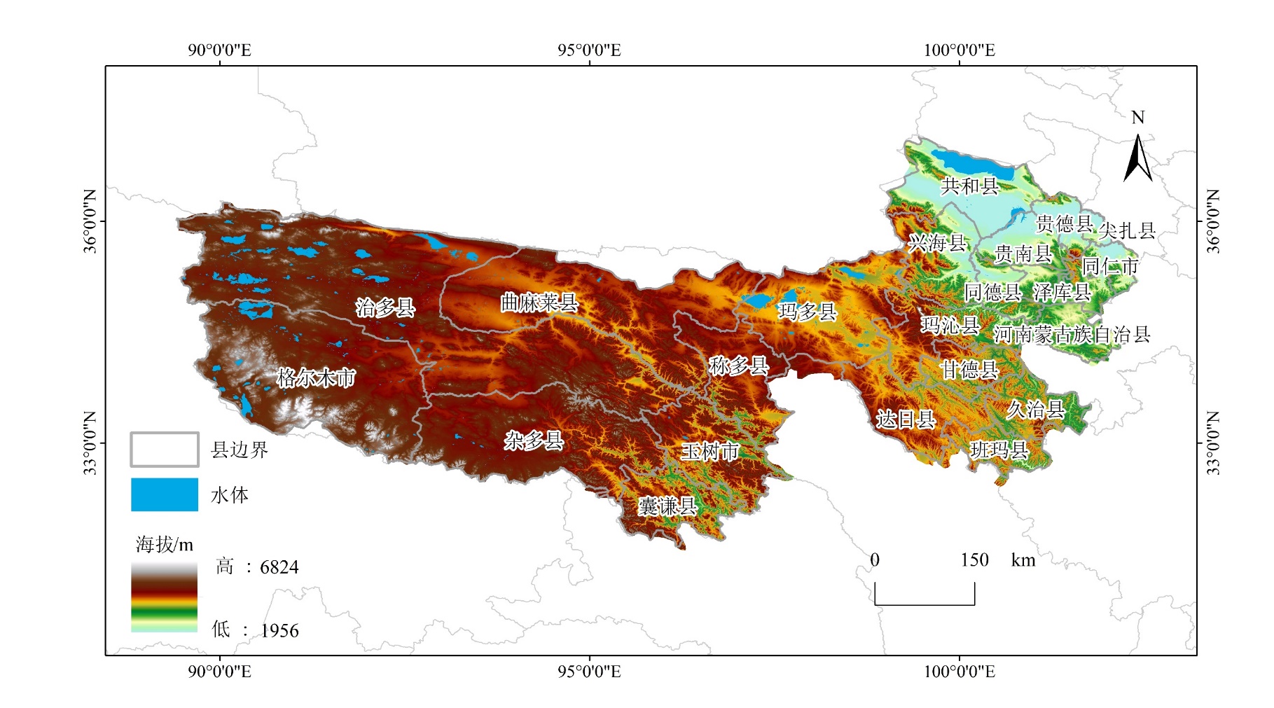
图1 三江源地区海拔与县区划位置
Figure 1 Elevation and location of counties in the Sanjiangyuan Region
| 数据名称 | 数据来源 |
|---|---|
| DEM数据 | 空间地理数据云 ( |
| 气象数据 | 国家地球系统科学数据中心 (www.geodata.cn) |
| 土壤数据 | 世界土壤数据库 (www.fao.org) |
| 归一化植被指数 | 国家青藏高原数据中心 ( |
| 产草量 | |
| 畜牧密度 | |
| 人均GDP | 资源环境科学数据平台 (www.resdc.cn) |
| 人口密度 |
表1 数据来源
Table 1 Data source
| 数据名称 | 数据来源 |
|---|---|
| DEM数据 | 空间地理数据云 ( |
| 气象数据 | 国家地球系统科学数据中心 (www.geodata.cn) |
| 土壤数据 | 世界土壤数据库 (www.fao.org) |
| 归一化植被指数 | 国家青藏高原数据中心 ( |
| 产草量 | |
| 畜牧密度 | |
| 人均GDP | 资源环境科学数据平台 (www.resdc.cn) |
| 人口密度 |
| 总指标层 | 指标类型 | 指标体系 | 指标名称 | 指标属性 | 指标代码 |
|---|---|---|---|---|---|
| 生态脆弱性评价指标体系 | 敏感性 | 地形因子 | 海拔 | 负向 | X1 |
| 坡度 | 正向 | X2 | |||
| 地形起伏度 | 正向 | X3 | |||
| 土壤因子 | 土壤侵蚀强度 | 正向 | X4 | ||
| 气象因子 | 年降水量 | 负向 | X5 | ||
| 年均气温 | 负向 | X6 | |||
| 干燥度 | 正向 | X7 | |||
| 相对湿度 | 负向 | X8 | |||
| 蒸散量 | 正向 | X9 | |||
| 恢复力 | 植被因子 | NDVI | 负向 | X10 | |
| 产草量 | 负向 | X11 | |||
| 压力度 | 人为压力 | 人口密度 | 正向 | X12 | |
| 经济压力 | 人均GDP密度 | 正向 | X13 | ||
| 畜牧密度 | 正向 | X14 |
表2 基于SRP模型的三江源区生态脆弱性评价指标体系
Table 2 Ecological vulnerability evaluation indicator system of Sanjiangyuan Region Based on SRP Model
| 总指标层 | 指标类型 | 指标体系 | 指标名称 | 指标属性 | 指标代码 |
|---|---|---|---|---|---|
| 生态脆弱性评价指标体系 | 敏感性 | 地形因子 | 海拔 | 负向 | X1 |
| 坡度 | 正向 | X2 | |||
| 地形起伏度 | 正向 | X3 | |||
| 土壤因子 | 土壤侵蚀强度 | 正向 | X4 | ||
| 气象因子 | 年降水量 | 负向 | X5 | ||
| 年均气温 | 负向 | X6 | |||
| 干燥度 | 正向 | X7 | |||
| 相对湿度 | 负向 | X8 | |||
| 蒸散量 | 正向 | X9 | |||
| 恢复力 | 植被因子 | NDVI | 负向 | X10 | |
| 产草量 | 负向 | X11 | |||
| 压力度 | 人为压力 | 人口密度 | 正向 | X12 | |
| 经济压力 | 人均GDP密度 | 正向 | X13 | ||
| 畜牧密度 | 正向 | X14 |
| 主成分 | 2000年 | 2010年 | 2020年 | ||||||||
|---|---|---|---|---|---|---|---|---|---|---|---|
| 特征值 | 贡献率/% | 累计贡献率/% | 特征值 | 贡献率/% | 累计贡献率/% | 特征值 | 贡献率/% | 累计贡献率/% | |||
| 1 | 0.04 | 53.99 | 53.99 | 0.06 | 51.12 | 51.12 | 0.05 | 49.19 | 49.19 | ||
| 2 | 0.03 | 22.24 | 76.24 | 0.03 | 23.64 | 74.76 | 0.03 | 25.39 | 74.58 | ||
| 3 | 0.01 | 8.14 | 84.38 | 0.01 | 7.81 | 82.56 | 0.01 | 7.92 | 82.50 | ||
| 4 | 0.01 | 5.16 | 89.54 | 0.01 | 5.22 | 87.78 | 0.01 | 5.89 | 88.39 | ||
| 5 | 0.01 | 3.80 | 93.34 | 0.01 | 4.42 | 92.20 | 0.01 | 4.41 | 92.80 | ||
| 6 | 0.00 | 2.20 | 95.54 | 0.00 | 2.93 | 95.13 | 0.00 | 2.34 | 95.14 | ||
| 7 | 0.00 | 1.36 | 96.90 | 0.00 | 1.66 | 96.79 | 0.00 | 1.45 | 96.60 | ||
| 8 | 0.00 | 0.95 | 97.85 | 0.00 | 1.11 | 97.90 | 0.00 | 1.12 | 97.72 | ||
| 9 | 0.00 | 0.79 | 98.64 | 0.00 | 0.82 | 98.72 | 0.00 | 0.88 | 98.60 | ||
| 10 | 0.00 | 0.47 | 99.11 | 0.00 | 0.55 | 99.27 | 0.00 | 0.63 | 99.23 | ||
| 11 | 0.00 | 0.38 | 99.49 | 0.00 | 0.33 | 99.60 | 0.00 | 0.41 | 99.63 | ||
| 12 | 0.00 | 0.22 | 99.70 | 0.00 | 0.18 | 99.78 | 0.00 | 0.16 | 99.79 | ||
| 13 | 0.00 | 0.16 | 99.87 | 0.00 | 0.11 | 99.89 | 0.00 | 0.11 | 99.91 | ||
| 14 | 0.00 | 0.13 | 100.00 | 0.00 | 0.11 | 100.00 | 0.00 | 0.09 | 100 | ||
表3 生态脆弱性指标主成分分析结果
Table 3 Results of principal component analysis of ecological vulnerability indicators
| 主成分 | 2000年 | 2010年 | 2020年 | ||||||||
|---|---|---|---|---|---|---|---|---|---|---|---|
| 特征值 | 贡献率/% | 累计贡献率/% | 特征值 | 贡献率/% | 累计贡献率/% | 特征值 | 贡献率/% | 累计贡献率/% | |||
| 1 | 0.04 | 53.99 | 53.99 | 0.06 | 51.12 | 51.12 | 0.05 | 49.19 | 49.19 | ||
| 2 | 0.03 | 22.24 | 76.24 | 0.03 | 23.64 | 74.76 | 0.03 | 25.39 | 74.58 | ||
| 3 | 0.01 | 8.14 | 84.38 | 0.01 | 7.81 | 82.56 | 0.01 | 7.92 | 82.50 | ||
| 4 | 0.01 | 5.16 | 89.54 | 0.01 | 5.22 | 87.78 | 0.01 | 5.89 | 88.39 | ||
| 5 | 0.01 | 3.80 | 93.34 | 0.01 | 4.42 | 92.20 | 0.01 | 4.41 | 92.80 | ||
| 6 | 0.00 | 2.20 | 95.54 | 0.00 | 2.93 | 95.13 | 0.00 | 2.34 | 95.14 | ||
| 7 | 0.00 | 1.36 | 96.90 | 0.00 | 1.66 | 96.79 | 0.00 | 1.45 | 96.60 | ||
| 8 | 0.00 | 0.95 | 97.85 | 0.00 | 1.11 | 97.90 | 0.00 | 1.12 | 97.72 | ||
| 9 | 0.00 | 0.79 | 98.64 | 0.00 | 0.82 | 98.72 | 0.00 | 0.88 | 98.60 | ||
| 10 | 0.00 | 0.47 | 99.11 | 0.00 | 0.55 | 99.27 | 0.00 | 0.63 | 99.23 | ||
| 11 | 0.00 | 0.38 | 99.49 | 0.00 | 0.33 | 99.60 | 0.00 | 0.41 | 99.63 | ||
| 12 | 0.00 | 0.22 | 99.70 | 0.00 | 0.18 | 99.78 | 0.00 | 0.16 | 99.79 | ||
| 13 | 0.00 | 0.16 | 99.87 | 0.00 | 0.11 | 99.89 | 0.00 | 0.11 | 99.91 | ||
| 14 | 0.00 | 0.13 | 100.00 | 0.00 | 0.11 | 100.00 | 0.00 | 0.09 | 100 | ||
| 等级 | 取值范围 | 敏感性 | 恢复力 | 脆弱性 |
|---|---|---|---|---|
| 1级 | ≤0.2 | 微度敏感 | 恢复力强 | 微度脆弱 |
| 2级 | 0.2‒0.4 | 轻度敏感 | 恢复力较强 | 轻度脆弱 |
| 3级 | 0.4‒0.6 | 中度敏感 | 恢复力一般 | 中度脆弱 |
| 4级 | 0.6‒0.8 | 重度敏感 | 恢复力较弱 | 重度脆弱 |
| 5级 | >0.8 | 极度敏感 | 恢复力弱 | 极度脆弱 |
表4 生态敏感性、恢复力和脆弱性分级标准
Table 4 Ecological sensitivity, resilience and vulnerability classification standards
| 等级 | 取值范围 | 敏感性 | 恢复力 | 脆弱性 |
|---|---|---|---|---|
| 1级 | ≤0.2 | 微度敏感 | 恢复力强 | 微度脆弱 |
| 2级 | 0.2‒0.4 | 轻度敏感 | 恢复力较强 | 轻度脆弱 |
| 3级 | 0.4‒0.6 | 中度敏感 | 恢复力一般 | 中度脆弱 |
| 4级 | 0.6‒0.8 | 重度敏感 | 恢复力较弱 | 重度脆弱 |
| 5级 | >0.8 | 极度敏感 | 恢复力弱 | 极度脆弱 |
| 判断依据 | 交互作用 |
|---|---|
| q(X1∩X2)<Min[q(X1), q(X2)] | 非线性减弱 |
| Min[q(X1), q(X2)] <q(X1∩X2)<Max[q(X1), q(X2)] | 单因子非线性减弱 |
| q(X1∩X2)>Max[q(X1), q(X2)] | 双因子增强 |
| q(X1∩X2)=q(X1)+q(X2) | 独立 |
| q(X1∩X2)>q(X1)+q(X2) | 非线性增强 |
表5 交互作用探测器交互作用类型
Table 5 Interaction typers of interactive detectors
| 判断依据 | 交互作用 |
|---|---|
| q(X1∩X2)<Min[q(X1), q(X2)] | 非线性减弱 |
| Min[q(X1), q(X2)] <q(X1∩X2)<Max[q(X1), q(X2)] | 单因子非线性减弱 |
| q(X1∩X2)>Max[q(X1), q(X2)] | 双因子增强 |
| q(X1∩X2)=q(X1)+q(X2) | 独立 |
| q(X1∩X2)>q(X1)+q(X2) | 非线性增强 |

图2 生态敏感性、恢复力和压力度指数空间分布变化
Figure 2 Changes in the spatial distribution of ecological sensitivity, resilience and stress indices

图3 三江源地区生态脆弱性空间分布图
Figure 3 Spatial distribution of ecological vulnerability in the Sanjiangyuan Region
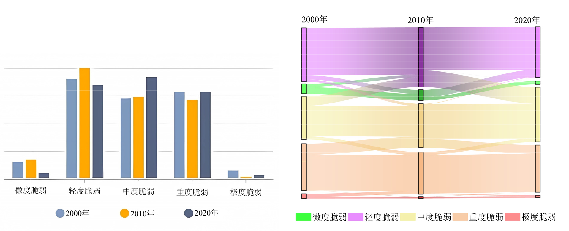
图4 三江源地区生态脆弱性情况及面积(km2)转移矩阵
Figure 4 Ecological vulnerability situation and area transfer matrix in the Sanjiangyuan Region
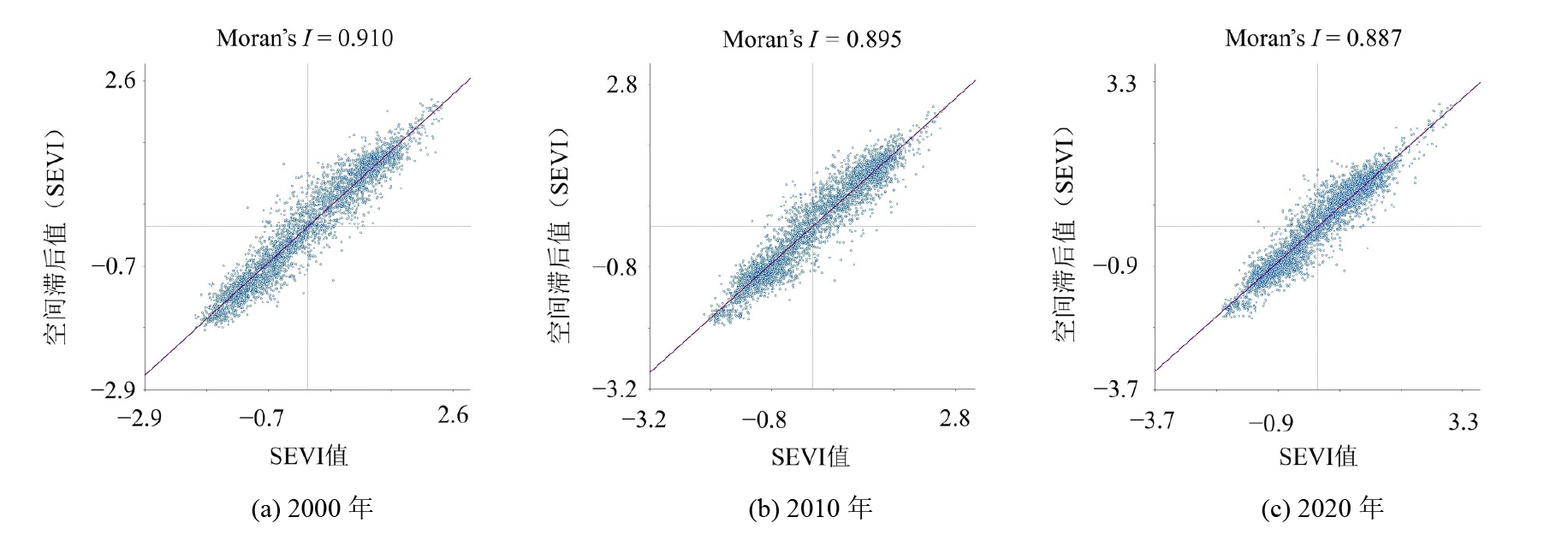
图5 2000年-2020年三江源地区生态脆弱性全局自相关散点图
Figure 5 Global spatial autocorrelation scatter plot in Sanjiangyuan region from 2000 to 2020

图6 三江源地区局部自相关分析LISA聚类图
Figure 6 Local autocorrelation analysis LISA clustering map in Sanjiangyuan Region
| 驱动因子 | 2000年 | 2010年 | 2020年 | |||||
|---|---|---|---|---|---|---|---|---|
| q值 | q值排序 | q值 | q值排序 | q值 | q值排序 | |||
| 海拔 (1) | 0.152 | 9 | 0.180 | 8 | 0.160 | 9 | ||
| 坡度 (2) | 0.320 | 8 | 0.180 | 9 | 0.360 | 8 | ||
| 地形起伏度 (3) | 0.387 | 6 | 0.414 | 6 | 0.434 | 6 | ||
| 土壤侵蚀强度 (4) | 0.354 | 7 | 0.114 | 10 | 0.460 | 5 | ||
| 年降水量 (5) | 0.806 | 1 | 0.840 | 1 | 0.788 | 1 | ||
| 气温 (6) | 0.122 | 11 | 0.110 | 11 | 0.128 | 11 | ||
| 干燥度 (7) | 0.768 | 2 | 0.602 | 3 | 0.746 | 2 | ||
| 相对湿度 (8) | 0.746 | 3 | 0.496 | 4 | 0.600 | 3 | ||
| 蒸散量 (9) | 0.110 | 12 | 0.099 | 13 | 0.087 | 12 | ||
| NDVI (10) | 0.590 | 4 | 0.647 | 2 | 0.485 | 4 | ||
| 产草量 (11) | 0.448 | 5 | 0.481 | 5 | 0.411 | 7 | ||
| 人口密度 (12) | 0.138 | 10 | 0.090 | 14 | 0.030 | 14 | ||
| GDP密度 (13) | 0.044 | 14 | 0.110 | 12 | 0.045 | 13 | ||
| 畜牧密度 (14) | 0.157 | 13 | 0.196 | 6 | 0.155 | 10 | ||
表6 三江源地区生态脆弱性因子探测q值
Table 6 The q value of ecological vulnerability factor detection in Sanjiangyuan region
| 驱动因子 | 2000年 | 2010年 | 2020年 | |||||
|---|---|---|---|---|---|---|---|---|
| q值 | q值排序 | q值 | q值排序 | q值 | q值排序 | |||
| 海拔 (1) | 0.152 | 9 | 0.180 | 8 | 0.160 | 9 | ||
| 坡度 (2) | 0.320 | 8 | 0.180 | 9 | 0.360 | 8 | ||
| 地形起伏度 (3) | 0.387 | 6 | 0.414 | 6 | 0.434 | 6 | ||
| 土壤侵蚀强度 (4) | 0.354 | 7 | 0.114 | 10 | 0.460 | 5 | ||
| 年降水量 (5) | 0.806 | 1 | 0.840 | 1 | 0.788 | 1 | ||
| 气温 (6) | 0.122 | 11 | 0.110 | 11 | 0.128 | 11 | ||
| 干燥度 (7) | 0.768 | 2 | 0.602 | 3 | 0.746 | 2 | ||
| 相对湿度 (8) | 0.746 | 3 | 0.496 | 4 | 0.600 | 3 | ||
| 蒸散量 (9) | 0.110 | 12 | 0.099 | 13 | 0.087 | 12 | ||
| NDVI (10) | 0.590 | 4 | 0.647 | 2 | 0.485 | 4 | ||
| 产草量 (11) | 0.448 | 5 | 0.481 | 5 | 0.411 | 7 | ||
| 人口密度 (12) | 0.138 | 10 | 0.090 | 14 | 0.030 | 14 | ||
| GDP密度 (13) | 0.044 | 14 | 0.110 | 12 | 0.045 | 13 | ||
| 畜牧密度 (14) | 0.157 | 13 | 0.196 | 6 | 0.155 | 10 | ||
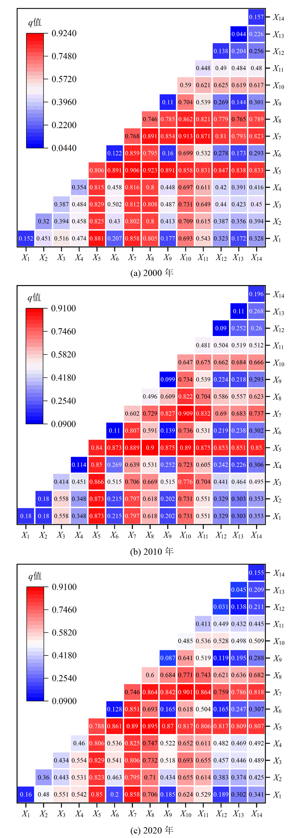
图7 生态脆弱性选取指标交互作用情况
Figure 7 Interaction of selected indicators of ecological vulnerability
| [1] | BEROYA E, MARY A, 2016. Ecological vulnerability indicators[J]. Ecological Indicators, 60: 329-334. |
| [2] | CHEN X W, LI X W, ELADAWY A, et al., 2021. A multi-dimensional vulnerability assessment of Pingtan Island (China) and Nile Delta (Egypt) using ecological Sensitivity-Resilience-Pressure (SRP) model[J]. Human and Ecological Risk Assessment, 27(7): 1860-1882. |
| [3] | DE LANGE H J, SALA S, VIGHI M, 2010. Ecological vulnerability in risk assessment: A review and perspectives[J]. Science of the Total Environment, 408(18): 3871-3879. |
| [4] | HOU K, TAO W D, WANG L M, et al., 2020. Study on hierarchical transformation mechanisms of regional ecological vulnerability and its applicability[J]. Ecological Indicator, 114: 106343. |
| [5] | JIANG X L, GUO X H, WU Y, et al., 2023. Ecological vulnerability assessment based on remote sensing ecological index (RSEI): A case of Zhongxian County, Chongqing[J]. Frontiers In Environmental Science, 10: 1074376. |
| [6] | LI A N, WANG A S, LIANG S L, et al., 2006. Eco-environmental vulnerability evaluation in mountainous region using remote sensing and GIS: A case study in the upper reaches of Minjiang River, China[J]. Ecological Modelling, 192(1): 175-187. |
| [7] | LI X X, YAN J P, ZHANG Y F, et al., 2021. Landscape ecological risk assessment under multiple indicators[J]. Land, 10(7): 739. |
| [8] | LUO M Y, JIA X, ZHAO Y H, et al., 2024. Ecological vulnerability assessment and its driving force based on ecological zoning in the Loess Plateau, China[J]. Ecological Indicators, 159: 111658. |
| [9] | QIAO Q, GAO J X, WANG W, et al., 2008. Method and application of ecological frangibility assessment[J]. Research of Environmental Sciences, 130(5): 117-123. |
| [10] | REN D F, CAO A H, 2022. Analysis of the heterogeneity of landscape risk evolution and driving factors based on a combined GeoDa and Geodetector mode[J]. Ecological Indicators, 144(10): 109568. |
| [11] | VAN N M, 1994. Biodiversity of ecotoxicological responses in animals[J]. Netherlands Journal of Zoology, 44(1): 112-129. |
| [12] | WANG Z Y, XIONG H X, ZHANG F W, et al., 2024. Sustainable development assessment of ecological vulnerability in arid areas under the influence of multiple indicators[J]. Journal Of Cleaner Production, 436: 140629. |
| [13] | 陈思杨, 刘瑞娟, 张晓辉, 等, 2024. 基于VSD模型的乐清湾生态系统脆弱性评价[J]. 应用海洋学学报, 43(3): 1-13. |
| CHEN S Y, LIU R J, ZHANG X H, et al., 2024. Vulnerability assessment of Yueqing Bay ecosystem based on VSD modeling[J]. Journal of Applied Oceanography, 43(3): 1-13. | |
| [14] | 崔晓萌, 2023. 基于生态脆弱性评价的生态修复关键区域识别与修复研究[D]. 徐州: 中国矿业大学: 10-11. |
| CUI X M, 2023. Identification and restoration of key ecological restoration areas based on ecological vulnerability assessment[D]. Xuzhou: China University of Mining and Technology: 10-11. | |
| [15] | 高向龙, 冯起, 李宗省, 等, 2024. 三江源水源涵养价值时空格局及关键影响因素研究[J]. 生态学报, 44(16): 1-13. |
| GAO X L, FENG Q, LI Z S, et al., 2024. 20204. Spatio-temporal patten and key influencing factors of water conservation value in the Three-River Source region[J]. Acta Eeologica Sinica, 44(16): 1-13. | |
| [16] | 郭贝贝, 崔莹雪, 2024. 基于RSEVI和地理探测器的安徽省5A级景区生态脆弱性评价[J]. 生态学杂志, 43(2): 550-563. |
|
GUO B B, CUI Y X, 2024. Ecological vulnerability assessment of scenic spots based on RSEVI and geographic detector[J]. Chinese Journal of Ecology, 43(2): 550-563.
DOI |
|
| [17] | 国家发展改革委, 2014. 青海三江源生态保护和建设二期工程规划[EB/OL]. [2014-1-8]. https://www.ndrc.gov.cn/fzggw/jgsj/njs/ sjdt/201404/W020191101564621097541.pdf. |
| The State Council of the People’s Republic of China, 2014. Qinghai Sanjiangyuan ecological protection and construction phase II project planning[EB/OL]. [2014-1-8]. https://www.ndrc.gov.cn/fzggw/jgsj/njs/ sjdt/201404/W020191101564621097541.pdf. | |
| [18] | 刘若琦, 黄志强, 2024. 基于AHP-GIS的宜春市生态敏感性评价[J]. 地理空间信息, 22(4): 54-59. |
| HUANG R Q, HUANG Z Q, 2024. Ecological Sensitivity Evaluation of Yichun City Based on AHP-GIS[J]. Geospatial Information, 22(4): 54-59. | |
| [19] |
贾雪梅, 高烨, 周涛, 等, 2021. 祁连山国家公园生态脆弱性评价——以张掖段为例[J]. 资源环境与工程, 35(3): 355-358.
DOI |
| JIA X M, GAO Y, ZHOU T, et al., 2021. Ecological vulnerability evaluation of Qilian Mountain National Park in Zhangye City[J]. Resources Environment & Engineering, 35(3): 355-358. | |
| [20] | 李怡, 赵小敏, 郭熙, 等, 2020. 江西省南昌市生态敏感性空间分异研究[J]. 中国农业大学学报, 25(10): 65-76. |
| LI Y, ZHAO X M, GUO X, et al., 2020. Study on spatial differentiation of ecological sensitivity in Nanchang City, Jiangxi Province[J]. Journal of China Agricultural University, 25(10): 65-76. | |
| [21] | 刘惠敏, 郑中团, 李文雯, 2022. 基于GIS的长三角城市群生态环境脆弱性综合评价[J]. 上海工程技术大学学报, 36(2): 224-230. |
| LIU H M, ZHENG Z T, LI W W, 2022. Comprehensive evaluation of ecological environment vulnerability of Yangtze River Delta urban agglomeration based on GIS[J]. Journal of Shanghai University of Engineering Science, 36(2): 224-230. | |
| [22] | 刘佳茹, 赵军, 沈思民, 等, 2020. 基于SRP概念模型的祁连山地区生态脆弱性评价[J]. 干旱区地理, 43(6): 1573-1582. |
|
LIU J R, ZHAO J, SHEN S M, et al., 2020. Ecological vulnerability assessment of Qilian Mountains region based on SRP conceptual model[J]. Arid Land Geography, 43(6): 1573-1582.
DOI |
|
| [23] | 玛沁县人民政府, 2007. 玛沁县三江源自然保护区生态保护和建设总体规划[EB/OL]. [2007-8-15] http://www.maqin.gov.cn/html/161/5861.html. |
| People's Government of Maqin County, 2007. Master Plan for Ecological Protection and Construction of Sanjiangyuan Nature Reserve in Maqin County[EB/OL]. [2007-8-15] http://www.maqin.gov.cn/html/161/5861.html. | |
| [24] | 苗旭, 李九一, 柳玉梅, 等, 2023. 鄂尔多斯市生态脆弱性评价及归因分析[J]. 西北林学院学报, 38(1): 168-173. |
| MIAO X, LI J Y, LIU Y M, et al., 2023. Evaluation and attribution analysis of ecological vulnerability in Ordos City[J]. Journal of Northwest Forestry University, 38(1): 168-173. | |
| [25] | 青海省生态环境厅, 2019. 青海三江源生态保护和建设二期工程阶段性生态成效综合评估[EB/OL]. [2019-12-6]. https://sthjt.qinghai.gov.cn/hjgl/sthjjc/sthjjcgl/201912/t20191206_104790.html. |
| Department of Ecology and Environment of Qinghai Province. Comprehensive assessment of the ecological effectiveness of the phase II project for the protection and construction of the Sanjiangyuan ecosystem in Qinghai[EB/OL]. [2019-12-6]. https://sthjt.qinghai.gov.cn/hjgl/sthjjc/sthjjcgl/201912/t20191206_104790.html. | |
| [26] | 石凡涛, 马仁萍, 2013. 三江源自然保护区生态保护与建设工程总体规划“黑土滩” 治理工程实施情况调查[J]. 黑龙江畜牧兽医, 3(5): 78-80. |
| SHI F T, MA R P, 2013. Survey on the implementation of the “black soil beach” treatment project under the master plan for the ecological protection and construction project of Sanjiangyuan Nature Reserve[J]. Heilongjiang Animal Science and Veterinary Medicine, 3(5): 78-80. | |
| [27] | 生态环境部, 2008. 全国生态脆弱区保护规划纲要[EB/OL]. [2008-9-7]. https://www.mee.gov.cn/gkml/hbb/bwj/200910/W020230202541194228270.pdf. |
| Ministry of Ecology and Environment of the People's Republic of China, 2008. Outline of the National Plan for the Protection of Ecologically Vulnerable Areas[EB/OL]. [2017-10-7]. https://www.mee.gov.cn/gkml/hbb/bwj/200910/W020230202541194228270.pdf. | |
| [28] |
孙桂丽, 陆海燕, 郑佳翔, 等, 2022. 新疆生态脆弱性时空演变及驱动力分析[J]. 干旱区研究, 39(1): 258-269.
DOI |
|
SUN G L, LU H Y, ZHENG J X, et al., 2022. Spatio-temporal variation of ecological vulnerability in Xinjiang and driving force analysis[J]. Arid Zone Research, 39(1): 258-269.
DOI |
|
| [29] |
孙智杰, 曾嘉, 王辛, 等, 2023. 基于GIS的通城县生态环境地质脆弱性评价[J]. 资源环境与工程, 37(5): 560-566.
DOI |
| SUN Z J, ZENG J, WANG X, 2023. Evaluation of eco-environmental geological vulnerability in Tongcheng county based on GIS[J]. Resources Environment & Engineering, 37(5): 560-566. | |
| [30] |
邵全琴, 樊江文, 刘纪远, 等, 2016. 三江源生态保护和建设一期工程生态成效评估[J]. 地理学报, 71(1): 3-20.
DOI |
| SHAO Q Q, FAN J W, LIU J Y, et al., 2016. Assessment on the effects of the first-stage ecological conservationand restoration project in Sanjiangyuan region[J]. Acta Geographica Sinica, 71(1): 3-20. | |
| [31] | 万鹏, 谭锶源, 2022. 乐山市2020年生态环境脆弱性评价[J]. 科技创新与应用, 12(21): 66-70. |
| WAN P, TAN S Y, 2022. Ecological Vulnerability Assessment of Leshan City in 2020[J]. Technology novation and Application, 12(21): 66-70. | |
| [32] | 王成军, 罗昕玥, 2023. 基于SRP模型榆林市生态脆弱性评价及时空演变研究[J]. 生产力研究, 10(10): 56-61. |
| WANG C J, LUO X Y, 2023. Study on ecological vulnerability evaluation and temporal and spatial evolution of Yulin City based on SRP modeling[J]. Productivity Studies, Productivity Studies, 10(10): 56-61. | |
| [33] | 王鹏, 赵微, 柯新利, 2021. 基于SRP模型的潜江市生态脆弱性评价及时空演变[J]. 水土保持研究, 28(5): 347-354. |
| WANG P, ZHAO W, KE X L, 2021. Evaluation and spatiotemporal evolution of ecological vulnerability of Qianjiang based on SRP model[J]. Research of Soil and Water Conservation, 28(5): 347-354. | |
| [34] | 王晓峰, 郑媛元, 孙泽冲, 等, 2024, 青藏高原自然保护区生态脆弱性演化与模拟[J/OL]. 环境科学, 1-15 [2024-07-14]. https://doi.org/10.13227/j.hjkx.202403096. |
| WANG X F, ZHENG Y Y, SUN Z C, et al., 2024. Evolution and Simulation of Ecological Vulnerability in Qinghai-Xizang Plateau Nature Reserve[J/OL]. Environmental Science, 1-15 [2024-07-14]. https://doi.org/10.13227/j.hjkx.202403096. | |
| [35] | 王钰帆, 白强, 孙虎, 2023. 2000-2020年汾河流域生态脆弱性时空演变与驱动因素[J]. 浙江大学学报(理学版), 50(5): 607-618. |
| WANG Y F, BAI Q, SUN H, 2023. Spatial-temporal evolution and driving factors of ecological vulnerability in Fenhe River Basin from 2000 to 2020[J]. Journal of Zhejiang University (Science Edition), 50(5): 607-618. | |
| [36] | 韦晶, 郭亚敏, 孙林, 等, 2015. 三江源地区生态环境脆弱性评价[J]. 生态学杂志, 34(7): 1968-1975. |
| WEI J, GUO Y M, SUN L, et al., Evaluation of ecological environment vulnerability for Sanjiangyuan area[J]. Chinese Journal of Ecology, 34(7): 1968-1975. | |
| [37] | 吴春生, 黄翀, 刘高焕, 等, 2018. 基于模糊层次分析法的黄河三角洲生态脆弱性评价[J]. 生态学报, 38(13): 4584-4595. |
| WU C S, HUANG C, LIU G H, et al., 2018. Assessment of ecological vulnerability in the Yellow River Delta using the Fuzzy Analytic Hierarchy Process[J]. Acta Ecologica Sinica, 38(13): 4584-4595. | |
| [38] | 徐君, 李贵芳, 王育红, 2015. 国内外资源型城市脆弱性研究综述与展望[J]. 资源科学, 37(6): 1266-1278. |
| XU J, LI G F, WANG Y H, 2015. Review and prospect of resource-based city vulnerability in China and Abroad[J]. Resources Science, 37(6): 1266-1278. | |
| [39] | 徐小玲, 2007. 三江源地区生态脆弱变化及经济与生态互动发展模式研究[D]. 西安: 陕西师范大学: 1-211. |
| XU X L, 2007. Research on ecological vulnerability change and interaction development modelof economy and ecology in Saniiangyuan Region[D]. Xian: Shanxi Normal University: 1-211. | |
| [40] | 徐至真, 2023. 基于SRP模型的柴达木盆地生态脆弱性时空分异及模拟预测研究[D]. 西宁: 中国科学院大学(中国科学院青海盐湖研究所): 1-2. |
| XU Z Z, 2023. Spatial and temporal differentiation and simulation prediction of ecological vulnerability in the Qaidam Basin based on SRP model[D]. Xining: University of Chinese Academy of Sciences (Qinghai Institute of Salt Lakes): 1-2 | |
| [41] | 杨祎, 王根绪, 李阳, 等, 2024. 三江源区草地水土保持与防风固沙功能临界植被覆盖度时空变化分析[J]. 山地学报, 42(2): 143-153. |
| YANG W, WANG G X, LI Y, et al., 2024. Spatial-temporal changes in the critical vegetation coverage of grasslands with function of soil-water conservation, wind-breaking and sand-fixing in Three-Rivers Headwater Region, China[J]. Mountain Research, 42(2): 143-153. | |
| [42] | 叶泉, 2022. 青藏高原东部边缘区自然环境灾害与生态脆弱性评估[D]. 上海: 华东师范大学: 1-73. |
| YE Q, 2022. Natural disasters and ecological vulnerability assessment in the eastern edge of the Qinghai-Tibet Plateau[D]. Shanghai: East China Normal University: 1-73. | |
| [43] | 喻春哲, 于欢, 项清, 等, 2023. 四川省生态脆弱性时空分异及其驱动机制[J/OL]. 环境科学, 1-17 [2024-09-05]. https://doi.org/10.13227/j.hjkx.202312110. |
| YU C Z, YU H, XIANG Q, et al., 2023. Spatio-temporal Differentiation and Its Driving Mechanism of Ecological Vulnerability in Sichuan Province[J/OL]. Environmental Science, 1-17 [2024-09-05]. https://doi.org/10.13227/j.hjkx.202312110. | |
| [44] | 岳笑, 张良侠, 周德成, 等, 2023. 干旱-半干旱典型生态脆弱区生态脆弱性时空演变及驱动因子分析[J]. 环境生态学, 5(6): 1-9. |
| YUE X, ZHANG L X, ZHOU D C, et al., 2023. Spatial-temporal variations and driving forces of the ecological vulnerability in the typical arid/ semi-arid ecological vulnerable areas[J]. Environmental Ecology, 5(6): 1-9. | |
| [45] | 张爱儒, 高新才, 2015. 青海藏区重要生态功能区生态脆弱度评价研究——以三江源生态功能区为例[J]. 西藏大学学报(社会科学版), 30(1): 1-8. |
| ZHANG A R, GAO X C, 2015. Ecological fragility assessment of the IEFA in Qinghai Tibetan area: A case study of the ecological function area in Sanjiangyuan[J]. Journal of Tibet University, 30(1): 1-8. | |
| [46] | 张学玲, 余文波, 蔡海生, 等, 2018. 区域生态环境脆弱性评价方法研究综述[J]. 生态学报, 38(16): 5970-5981. |
| ZHANG X L, YU W B, CAI H S, et al., 2018. Review of the evaluation methods of regional eco-environmental vulnerability[J]. Acta Ecologica Sinica, 38(16): 5970-5981. | |
| [47] | 张颖, 2022. 闽三角城市群土地利用变化及生态脆弱性研究[D]. 南昌: 东华理工大学: 1-59. |
| ZHANG Y, 2022. Study on land use change and ecological vulnerability of urban agglomeration in Fujian Delta[D]. Nanchang: East China Institute of Technology: 1-59. | |
| [48] | 赵怀涛, 常浩, 王鹏, 2023. 基于主成分分析法的矿区生态环境脆弱性评估方法[J]. 煤化工, 51(5): 125-128. |
| ZHAO H T, CHANG H, WANG P, 2023. Assessment method of ecological environment vulnerability in mining area based on principal component analysis[J]. Coal Chemical Industry, 51(5): 125-128. | |
| [49] | 支泽民, 刘峰贵, 陈琼, 等, 2022. 青海省生态脆弱度分级1 km栅格数据集(2015)的研发与内容[J]. 全球变化数据学报, 6(3): 409-415. |
| ZHI Z M, LIU F G, CHEN Q, et al., 2022. Development of ecological vulnerability classification 1km raster dataset in Qinghai Province of China (2015)[J]. Journal of Global Change Data & Discovery, 6(3): 409-415. |
| [1] | 张舒涵, 姜海玲, 于海淋, 冯馨慧. 沈阳现代化都市圈景观生态风险时空演变及驱动力分析[J]. 生态环境学报, 2024, 33(9): 1471-1481. |
| [2] | 李新妹, 吴作航, 王震山, 翁升恒, 孙朝锋, 关辉, 王宏. 基于MODIS遥感数据的福建植被生产力时空分布与干旱响应分析[J]. 生态环境学报, 2024, 33(6): 841-852. |
| [3] | 何沐全, 石艳军, 王晨茜, 罗祖红, 张少通. 广东省植被生态质量演变与气象条件贡献分析[J]. 生态环境学报, 2024, 33(5): 679-688. |
| [4] | 王美娜, 范顺祥, 舒翰俊, 张建杰, 褚力其, 法玉琦. 河南省土壤侵蚀时空分异特征及土壤保持经济价值[J]. 生态环境学报, 2024, 33(5): 730-744. |
| [5] | 程鹏, 孙明东, 宋晓伟. 中国灰水足迹时空动态演进及驱动因素研究[J]. 生态环境学报, 2024, 33(5): 745-756. |
| [6] | 杨非凡, 何浩. 基于“EVI-ESV”伊犁河谷生态环境评估及生态分区构建[J]. 生态环境学报, 2024, 33(4): 655-664. |
| [7] | 张杨, 徐永明, 卢响军, 莫亚萍, 吉蒙, 祝善友. 基于OCO-2遥感数据的新疆维吾尔自治区大气XCO2空间化研究[J]. 生态环境学报, 2024, 33(2): 231-241. |
| [8] | 李荣杰, 李惠梅, 武非非, 赵明德, 王诗涵, 孙雪颖. 青海湖流域生态系统服务空间分异规律及驱动力研究[J]. 生态环境学报, 2024, 33(2): 301-309. |
| [9] | 袁茜, 傅开道, 陶雨晨, 张年, 杨丽莎. 澜沧江(云南段)水-气界面氧化亚氮释放通量时空分布特征及其影响因素研究[J]. 生态环境学报, 2024, 33(1): 54-61. |
| [10] | 吴雅睿, 王美景, 王涛, 杨梅焕. 新冠疫情下NO2时空变化特征——以陕西省为例[J]. 生态环境学报, 2023, 32(3): 514-524. |
| [11] | 李姝亭, 胡冠九, 罗小三. 大气环境中全(多)氟烷基化合物(PFASs)的来源、分布及健康风险研究进展[J]. 生态环境学报, 2023, 32(12): 2103-2114. |
| [12] | 刘明宇, 郑旭, 强丽媛, 李鲁华, 张若宇, 王家平. 1994-2020年中国农用薄膜使用量变化与农膜微塑料污染现状分析[J]. 生态环境学报, 2023, 32(11): 2050-2061. |
| [13] | 肖成志, 计扬, 李建忠, 张志, 巴仁基, 曹亚廷. 岷江上游生态脆弱性时空分异及驱动因子交互效应分析——以杂谷脑河流域为例[J]. 生态环境学报, 2023, 32(10): 1760-1770. |
| [14] | 孙正, 曹亚非, 王德彩, 刘峰, 宋效东, 张甘霖, 吴华勇. 近30年京津冀电镀场地时空演变特征及趋势预测[J]. 生态环境学报, 2023, 32(1): 183-194. |
| [15] | 贺斌, 胡茂川. 广东省各区县农业面源污染负荷估算及特征分析[J]. 生态环境学报, 2022, 31(4): 771-776. |
| 阅读次数 | ||||||
|
全文 |
|
|||||
|
摘要 |
|
|||||