生态环境学报 ›› 2023, Vol. 32 ›› Issue (10): 1760-1770.DOI: 10.16258/j.cnki.1674-5906.2023.10.005
肖成志1,2( ), 计扬1,3,*(), 李建忠1, 张志2, 巴仁基1, 曹亚廷1
收稿日期:2023-07-19
出版日期:2023-10-18
发布日期:2024-01-16
通讯作者:
*计扬。E-mail: 553024034@qq.com作者简介:肖成志(1994年生),男,硕士研究生,研究方向为生态环境遥感。E-mail: 1202020648@cug.edu.cn
基金资助:
XIAO Chengzhi1,2(), JI Yang1,3,*(), LI Jianzhong1, ZHANG Zhi2, BA Renji1, CAO Yating1
Received:2023-07-19
Online:2023-10-18
Published:2024-01-16
摘要:
岷江上游是中国重要的生态屏障,特别是干旱河谷区不但生态环境脆弱,而且是人类活动主要区域。2008年5•12地震对该区域生态环境造成了重大影响。为探索5•12地震前后岷江上游生态环境变化状况,同时探究该区域生态脆弱性驱动机制,以杂谷脑河流域为例,从“自然环境-地质地貌-地质灾害-社会环境”4个维度选取了14个评价指标,基于空间主成分分析对该区域5•12地震震前(2001年)、震后(2009年)及现状(2020年)生态脆弱性进行评价。基于地理探测器分析了生态脆弱性影响因子,并计算交互效应变异比量化了驱动因子的个体效应(直接影响)和交互效应(间接影响)。结果表明,相对于震前震后区域内潜在和轻度脆弱区面积减少,微度、中度和重度脆弱区面积增加,生态脆弱性增强;经多年恢复现今区域内潜在、微度和轻度脆弱区域面积增加,中度、重度脆弱区域面积有不同程度的减少,生态脆弱性降低。岷山、邛崃山冰蚀、冰缘极高山、高山区轻度和重度脆弱区分布最广面积占比分别为25.8%和36.3%,生态脆弱性最高;干旱河谷区微度和轻度脆弱区面积分布最广面积占比分别为46.6%和33.9%,生态脆弱性较高;其他区域主要为潜在脆弱区面积占比均在74.5%以上,生态脆弱性低。高程、生物丰度指数、植被覆盖度、水源涵养指数和干旱指数是区域内生态脆弱性主要驱动因子,其中,高程是最直接的影响因子,而植被覆盖度和水源涵养指数对生态脆弱性间接影响力不断加强,干旱指数在气候干燥时期对生态脆弱性直接影响力增强,生物丰度指数对生态脆弱性直接影响显著,但在震后对研究区生态脆弱性间接影响增强。
中图分类号:
肖成志, 计扬, 李建忠, 张志, 巴仁基, 曹亚廷. 岷江上游生态脆弱性时空分异及驱动因子交互效应分析——以杂谷脑河流域为例[J]. 生态环境学报, 2023, 32(10): 1760-1770.
XIAO Chengzhi, JI Yang, LI Jianzhong, ZHANG Zhi, BA Renji, CAO Yating. Spatial and Temporal Differentiation of Ecological Vulnerability and Interaction Effects of Driving Factors in the Upper reaches of the Minjiang River: A Case Study of the Zagunao River Basin[J]. Ecology and Environment, 2023, 32(10): 1760-1770.
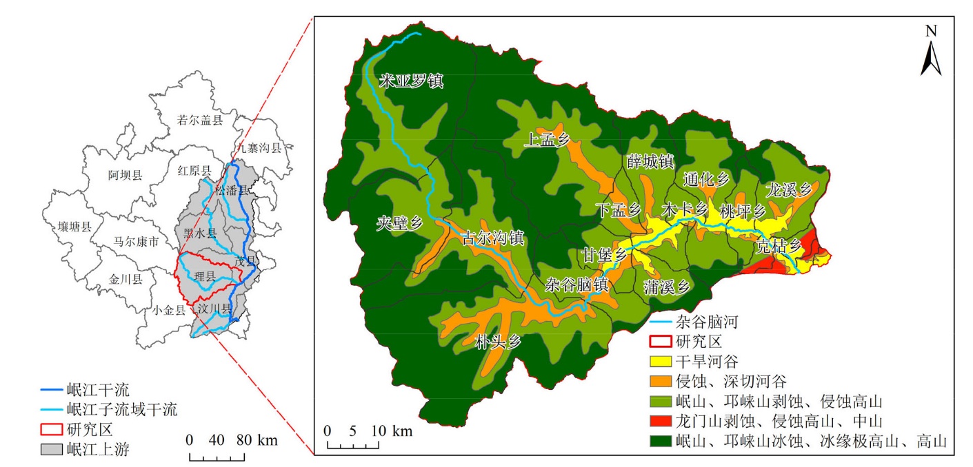
图1 研究区概况示意图
Figure 1 Overview of the study area
| 数据 | 数据源 | 数据集 |
|---|---|---|
| 地层岩性、地质灾害点、地貌分区数据 | 四川省地质调查院 | 岷江流域地质灾害详细调查成果集成报告 |
| 土壤类型数据 | 2019年四川省耕地等别数据 | |
| 干旱河谷矢量边界 | 中国科学院、水利部成都山地灾害与环境研究所 ( | 西南干旱河谷范围 (范建容等, |
| 土地利用 (2001、2009、2020年) | https://zenodo.org/ | The 30 m annual land cover datasets and its dynamics in China from 1990 to 2021 (Yang et al., |
| 降雨 (2001、2009、2020年) | 中国科学数据网 ( | Monthly precipitation data set with 1 km resolution in China from 1960 to 2020 (Qu et al., |
| 潜在蒸发 (2001、2009、2020年) | 国家青藏高原科学数据中心 ( | 中国1 km逐月潜在蒸散发数据集 (1990-2021) (彭守璋, |
| 人口密度 (2001、2009、2020年) | | World Pop人口密度数据 |
表1 数据源
Table 1 Data Sources
| 数据 | 数据源 | 数据集 |
|---|---|---|
| 地层岩性、地质灾害点、地貌分区数据 | 四川省地质调查院 | 岷江流域地质灾害详细调查成果集成报告 |
| 土壤类型数据 | 2019年四川省耕地等别数据 | |
| 干旱河谷矢量边界 | 中国科学院、水利部成都山地灾害与环境研究所 ( | 西南干旱河谷范围 (范建容等, |
| 土地利用 (2001、2009、2020年) | https://zenodo.org/ | The 30 m annual land cover datasets and its dynamics in China from 1990 to 2021 (Yang et al., |
| 降雨 (2001、2009、2020年) | 中国科学数据网 ( | Monthly precipitation data set with 1 km resolution in China from 1960 to 2020 (Qu et al., |
| 潜在蒸发 (2001、2009、2020年) | 国家青藏高原科学数据中心 ( | 中国1 km逐月潜在蒸散发数据集 (1990-2021) (彭守璋, |
| 人口密度 (2001、2009、2020年) | | World Pop人口密度数据 |
| 类型 | 指标 | 性质 | 指标说明与计算 |
|---|---|---|---|
| 自然环境 | 植被覆盖度x1 | 逆向 | 反映植被在该区域内的分布情况和覆盖程度, 基于Landsat数据计算NDVI, 采用像元二分模型计算植被覆盖度 |
| 干旱指数x2 | 正向 | 反映区域内气候干燥或湿润, 可表示为潜在蒸发量和降雨的量的比值。干旱植被指数大于1表示干燥, 小于1表示湿润 | |
| 土壤含水量x3 | 逆向 | 反映土壤绝对含水量, 基于Landsat热红外波段采用单窗算法反演地表温度 (Ts), 构建Ts-NDVI特征空间计算温度干旱植被指数 (Temperature Vegetation Drought Index, TVDI) 以提供土壤含水信息。TVDI值范围为0-1, 值越大土壤含水量越低 | |
| 水源涵养指数x4 | 逆向 | 反映区域土壤和植被对水资源的保持能力, 计算方法参考2001年10月印发的《区域生态质量评价方法 (试行)》 | |
| 生物丰度指数x5 | 逆向 | 反映生态系统内物种数量、种类和数量分布的情况, 计算方法参考《生态环境状况评价技术规范 (试行) HJ/T 192—2006》 | |
| 地质地貌 | 高程x6 | 正向 | 指地表相对于平均海平面的高度, 高程的变化会导致气温的变化水资源的供应以及植被类型和土壤类型的分布 |
| 坡度x7 | 正向 | 反映了地表的倾斜度或斜度, 坡度的大小直接影响着地表的水分流, 基于ArcGIS使用DEM数据提取坡度 | |
| 地层岩性x8 | 正向 | 反映不同岩性特征, 岩石的软硬程度决定了其风化速率, 岩石是否易被风化成土壤对植被生长环境影响巨大 | |
| 土壤类型x9 | 正向 | 反映不同土壤特征, 土壤物理化学性质影响植被生长发育 | |
| 河网密度x10 | 正向 | 反映流域内干支流总河长与流域面积的比值, 基于ArcGIS使用DEM提取河网, 计算单位面积内河流长度 | |
| 地质灾害 | 土壤侵蚀x11 | 正向 | 反映土壤流失量情况, 基于通用土壤流失方程 (Universal Soil Loss Equation, USLE) 计算土壤侵蚀模数 |
| 地质灾害密度x12 | 正向 | 反映区域内灾害密集程度, 基于ArcGIS软件核密度分析计算地质灾害点密度 | |
| 社会环境 | 人口密度x13 | 正向 | 反映区域内人口密集程度 |
| 离道路距离x14 | 逆向 | 反映人类工程活动影响强度, 采用欧氏距离法对道路矢量数据进行缓冲 |
表2 杂谷脑河流域生态脆弱性评价指标体系
Table 2 Ecological vulnerability assessment index system in the Zagunao River basin
| 类型 | 指标 | 性质 | 指标说明与计算 |
|---|---|---|---|
| 自然环境 | 植被覆盖度x1 | 逆向 | 反映植被在该区域内的分布情况和覆盖程度, 基于Landsat数据计算NDVI, 采用像元二分模型计算植被覆盖度 |
| 干旱指数x2 | 正向 | 反映区域内气候干燥或湿润, 可表示为潜在蒸发量和降雨的量的比值。干旱植被指数大于1表示干燥, 小于1表示湿润 | |
| 土壤含水量x3 | 逆向 | 反映土壤绝对含水量, 基于Landsat热红外波段采用单窗算法反演地表温度 (Ts), 构建Ts-NDVI特征空间计算温度干旱植被指数 (Temperature Vegetation Drought Index, TVDI) 以提供土壤含水信息。TVDI值范围为0-1, 值越大土壤含水量越低 | |
| 水源涵养指数x4 | 逆向 | 反映区域土壤和植被对水资源的保持能力, 计算方法参考2001年10月印发的《区域生态质量评价方法 (试行)》 | |
| 生物丰度指数x5 | 逆向 | 反映生态系统内物种数量、种类和数量分布的情况, 计算方法参考《生态环境状况评价技术规范 (试行) HJ/T 192—2006》 | |
| 地质地貌 | 高程x6 | 正向 | 指地表相对于平均海平面的高度, 高程的变化会导致气温的变化水资源的供应以及植被类型和土壤类型的分布 |
| 坡度x7 | 正向 | 反映了地表的倾斜度或斜度, 坡度的大小直接影响着地表的水分流, 基于ArcGIS使用DEM数据提取坡度 | |
| 地层岩性x8 | 正向 | 反映不同岩性特征, 岩石的软硬程度决定了其风化速率, 岩石是否易被风化成土壤对植被生长环境影响巨大 | |
| 土壤类型x9 | 正向 | 反映不同土壤特征, 土壤物理化学性质影响植被生长发育 | |
| 河网密度x10 | 正向 | 反映流域内干支流总河长与流域面积的比值, 基于ArcGIS使用DEM提取河网, 计算单位面积内河流长度 | |
| 地质灾害 | 土壤侵蚀x11 | 正向 | 反映土壤流失量情况, 基于通用土壤流失方程 (Universal Soil Loss Equation, USLE) 计算土壤侵蚀模数 |
| 地质灾害密度x12 | 正向 | 反映区域内灾害密集程度, 基于ArcGIS软件核密度分析计算地质灾害点密度 | |
| 社会环境 | 人口密度x13 | 正向 | 反映区域内人口密集程度 |
| 离道路距离x14 | 逆向 | 反映人类工程活动影响强度, 采用欧氏距离法对道路矢量数据进行缓冲 |
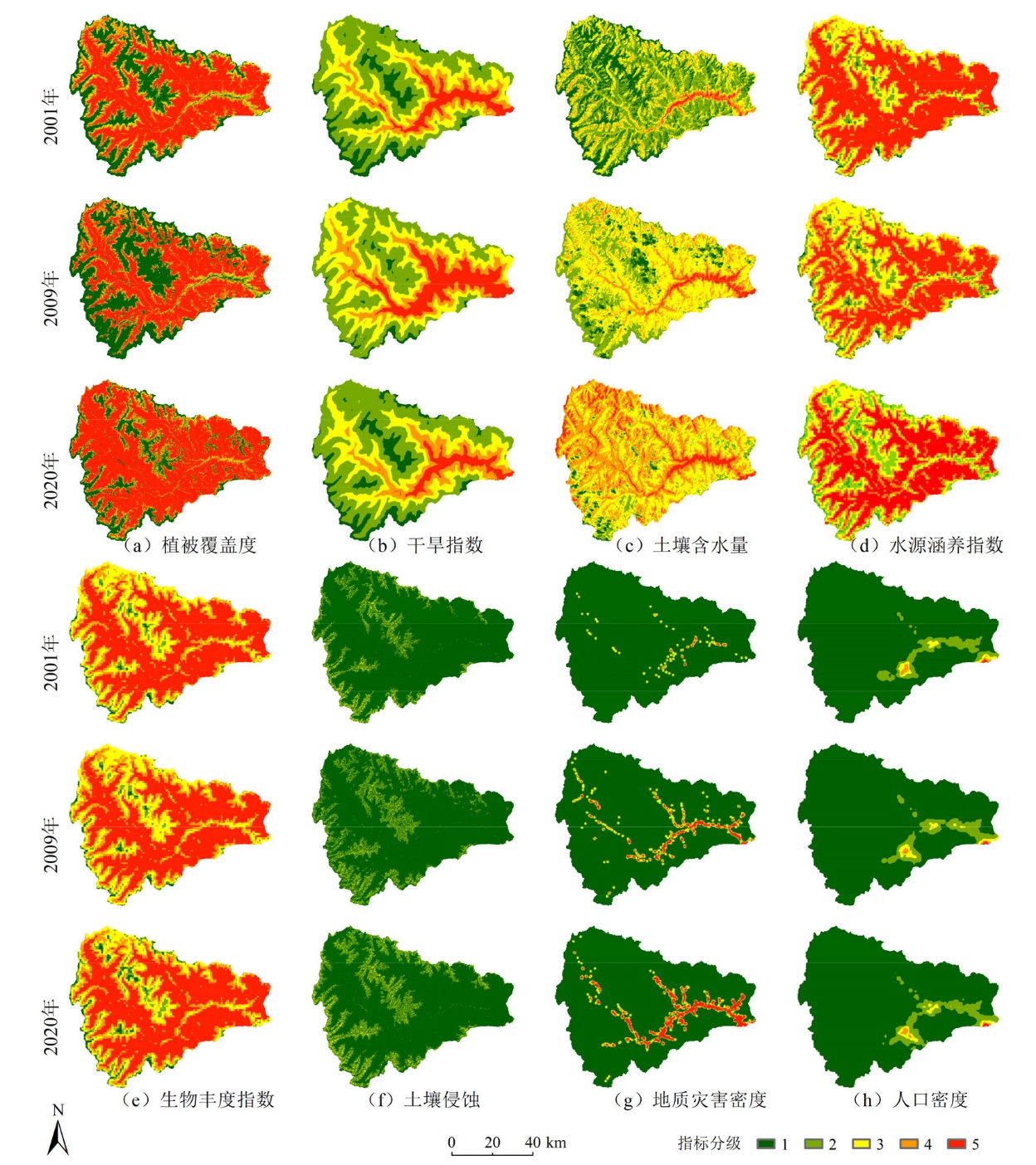
图2 动态变化指标空间分布特征
Figure 2 Spatial distribution characteristics of dynamic change indicators
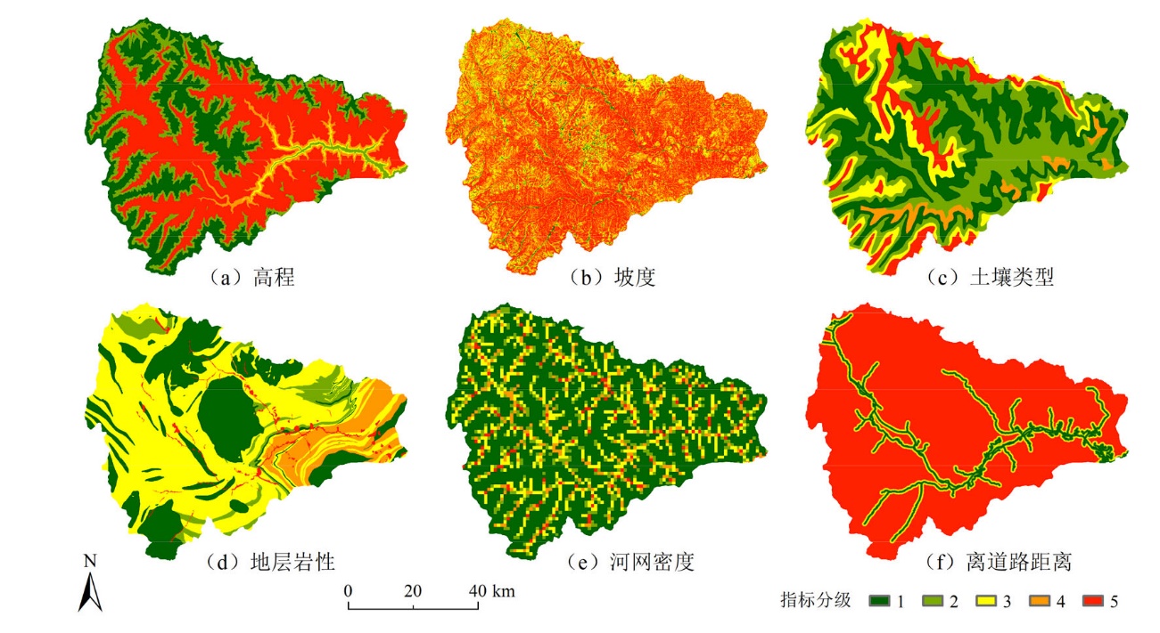
图3 稳定指标空间分布特征
Figure 3 Spatial distribution characteristics of stability indicators
| 指标 | 评价指标分级 | 参考或方法 | ||||
|---|---|---|---|---|---|---|
| 1 | 2 | 3 | 4 | 5 | ||
| 植被覆盖度 | 0‒30% | 30%‒45% | 45%‒60% | 60%‒75% | 75%‒100% | 廖凯涛等, |
| 干旱指数 | <0.4 | 0.4‒0.6 | 0.6‒0.8 | 0.8‒1 | >1 | 自然间断点法 |
| 土壤含水量 | 0‒0.2 | 0.2‒0.4 | 0.4‒0.6 | 0.6‒0.8 | 0.8‒1 | 田鑫等, |
| 水源涵养指数 | 0‒15 | 15‒40 | 40‒55 | 55‒70 | 70‒100 | 自然间断点法 |
| 生物丰度指数 | 0-50 | 50‒60 | 60‒70 | 70‒80 | 80‒100 | 自然间断点法 |
| 高程/km | 2.3‒3.8 | 1.9‒2.3 | 1.7‒1.9 | <1.7、3.8‒4.2 | >4.2 | 区域实际情况 |
| 坡度/(°) | 0‒8 | 8‒15 | 15‒25 | 25‒35 | >35 | 汤国安等, |
| 地层岩性 | 坚硬岩类 | 半坚硬岩类 | 软硬相间岩类 | 软弱岩 | 松散土体 | 王若飞等, |
| 土壤类型 | 暗棕壤、棕壤 | 褐土 | 棕色针叶林土、亚高山草甸土、高山草甸土 | 粗骨土 | 高山寒漠土 | 程欢等, |
| 河网密度/(km∙km−2) | 0‒0.27 | 0.27‒0.81 | 0.81‒1.32 | 0.32‒1.83 | 1.83‒3.18 | 自然间断点法 |
| 土壤侵蚀/(t∙hm−2∙a−1) | <500 | 500‒2500 | 2500‒5000 | 5000‒8000 | >8000 | 魏健美等, |
| 地质灾害密度/(pieces∙km−2) | 0‒0.2 | 0.2‒0.6 | 0.6‒1 | 1‒1.5 | >1.5 | 自然间断点法 |
| 人口密度/(person∙km−2) | <90 | 90‒280 | 280‒640 | 640‒1090 | >1090 | 自然间断点法 |
| 与道路的距离/m | <200 | 200-400 | 400-600 | 600-800 | >800 | Li et al., |
表3 杂谷脑河流域生态脆弱性评价指标分级标准
Table 3 Classification criteria of ecological vulnerability indexes in the Zagunao River basin
| 指标 | 评价指标分级 | 参考或方法 | ||||
|---|---|---|---|---|---|---|
| 1 | 2 | 3 | 4 | 5 | ||
| 植被覆盖度 | 0‒30% | 30%‒45% | 45%‒60% | 60%‒75% | 75%‒100% | 廖凯涛等, |
| 干旱指数 | <0.4 | 0.4‒0.6 | 0.6‒0.8 | 0.8‒1 | >1 | 自然间断点法 |
| 土壤含水量 | 0‒0.2 | 0.2‒0.4 | 0.4‒0.6 | 0.6‒0.8 | 0.8‒1 | 田鑫等, |
| 水源涵养指数 | 0‒15 | 15‒40 | 40‒55 | 55‒70 | 70‒100 | 自然间断点法 |
| 生物丰度指数 | 0-50 | 50‒60 | 60‒70 | 70‒80 | 80‒100 | 自然间断点法 |
| 高程/km | 2.3‒3.8 | 1.9‒2.3 | 1.7‒1.9 | <1.7、3.8‒4.2 | >4.2 | 区域实际情况 |
| 坡度/(°) | 0‒8 | 8‒15 | 15‒25 | 25‒35 | >35 | 汤国安等, |
| 地层岩性 | 坚硬岩类 | 半坚硬岩类 | 软硬相间岩类 | 软弱岩 | 松散土体 | 王若飞等, |
| 土壤类型 | 暗棕壤、棕壤 | 褐土 | 棕色针叶林土、亚高山草甸土、高山草甸土 | 粗骨土 | 高山寒漠土 | 程欢等, |
| 河网密度/(km∙km−2) | 0‒0.27 | 0.27‒0.81 | 0.81‒1.32 | 0.32‒1.83 | 1.83‒3.18 | 自然间断点法 |
| 土壤侵蚀/(t∙hm−2∙a−1) | <500 | 500‒2500 | 2500‒5000 | 5000‒8000 | >8000 | 魏健美等, |
| 地质灾害密度/(pieces∙km−2) | 0‒0.2 | 0.2‒0.6 | 0.6‒1 | 1‒1.5 | >1.5 | 自然间断点法 |
| 人口密度/(person∙km−2) | <90 | 90‒280 | 280‒640 | 640‒1090 | >1090 | 自然间断点法 |
| 与道路的距离/m | <200 | 200-400 | 400-600 | 600-800 | >800 | Li et al., |
| 判断依据 | 交互作用 |
|---|---|
| q(x1∩x2)<Min[q(x1), q(x2)] | 非线性减弱 |
| Min[q(x1), q(x2)]<q(x1∩x2)<Max[q(x1), q(x2)] | 单因子非线性减弱 |
| q(x1∩x2)>Max[q(x1), q(x2)] | 双因子增强 |
| q(x1∩x2)=q(x1)+q(x2) | 独立 |
| q(x1∩x2)>q(x1)+q(x2) | 非线性增强 |
表4 交互探测类型
Table 4 Types of interactive detection
| 判断依据 | 交互作用 |
|---|---|
| q(x1∩x2)<Min[q(x1), q(x2)] | 非线性减弱 |
| Min[q(x1), q(x2)]<q(x1∩x2)<Max[q(x1), q(x2)] | 单因子非线性减弱 |
| q(x1∩x2)>Max[q(x1), q(x2)] | 双因子增强 |
| q(x1∩x2)=q(x1)+q(x2) | 独立 |
| q(x1∩x2)>q(x1)+q(x2) | 非线性增强 |
| 年份 | 项目 | 主成分 | |||||
|---|---|---|---|---|---|---|---|
| PC1 | PC2 | PC3 | PC4 | PC5 | PC6 | ||
| 2001 | 特征值/λ | 0.29 | 0.07 | 0.05 | 0.04 | 0.03 | 0.03 |
| 贡献率/% | 49.55 | 12 | 8.27 | 6.76 | 5.31 | 4.5 | |
| 累计贡献率/% | 49.55 | 61.55 | 69.82 | 76.58 | 81.88 | 86.38 | |
| 2009 | 特征值/λ | 0.3 | 0.08 | 0.05 | 0.04 | 0.03 | 0.03 |
| 贡献率/% | 49.09 | 12.2 | 7.99 | 6.7 | 5.35 | 5.02 | |
| 累计贡献率/% | 49.09 | 61.29 | 69.28 | 75.98 | 81.33 | 86.35 | |
表5 各主成分的特征值、贡献率及累计贡献率表
Table 5 Eigenvalue, contribution rate and cumulative contribution rate of principal component
| 年份 | 项目 | 主成分 | |||||
|---|---|---|---|---|---|---|---|
| PC1 | PC2 | PC3 | PC4 | PC5 | PC6 | ||
| 2001 | 特征值/λ | 0.29 | 0.07 | 0.05 | 0.04 | 0.03 | 0.03 |
| 贡献率/% | 49.55 | 12 | 8.27 | 6.76 | 5.31 | 4.5 | |
| 累计贡献率/% | 49.55 | 61.55 | 69.82 | 76.58 | 81.88 | 86.38 | |
| 2009 | 特征值/λ | 0.3 | 0.08 | 0.05 | 0.04 | 0.03 | 0.03 |
| 贡献率/% | 49.09 | 12.2 | 7.99 | 6.7 | 5.35 | 5.02 | |
| 累计贡献率/% | 49.09 | 61.29 | 69.28 | 75.98 | 81.33 | 86.35 | |
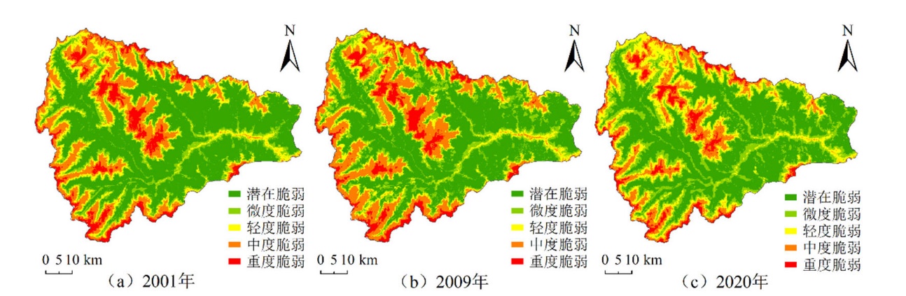
图4 2001、2009和2020年杂谷脑河流域生态脆弱性分级图
Figure 4 Ecological vulnerability classification diagram of the Zagunao River Basin in 2001, 2009, 2020
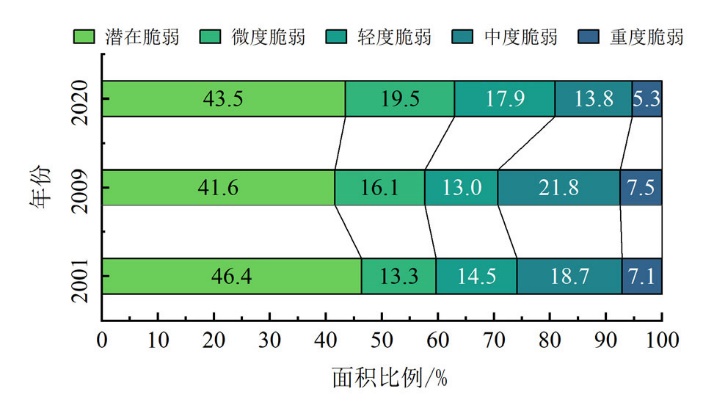
图5 2001、2009和2020年杂谷脑河流域生态脆弱性面积比例
Figure 5 Proportion of ecological vulnerable area in the Zagunao River Basin in 2001, 2009, 2020
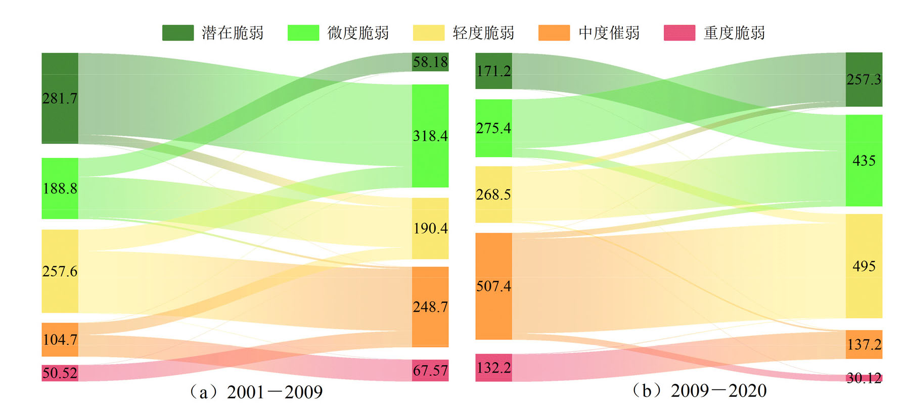
图6 不同时期生态脆弱性转移桑基图
Figure 6 Sankey diagram of ecological vulnerability transfer in different periods
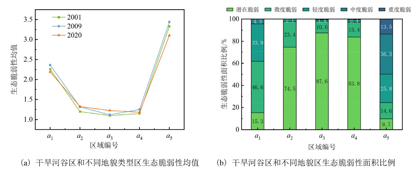
图7 干旱河谷区、不同地貌类型区生态脆弱性均值及面积比例
Figure 7 Mean value and area proportion of ecological vulnerability in arid valley and different geomorphic types
| 因子 | 2001年 | 2009年 | 2020年 | 均值 | ||||||||
|---|---|---|---|---|---|---|---|---|---|---|---|---|
| q值 | 排序 | q值 | 排序 | q值 | 排序 | q值 | 排序 | |||||
| 自然环境 | 植被覆盖度 (x1) | 0.853 | 2 | 0.792 | 2 | 0.569 | 5 | 0.739 | 3 | |||
| 干旱指数 (x2) | 0.630 | 5 | 0.716 | 4 | 0.619 | 4 | 0.655 | 5 | ||||
| 土壤含水量 (x3) | 0.158 | 8 | 0.339 | 6 | 0.090 | 10 | 0.196 | 8 | ||||
| 水源涵养指数 (x4) | 0.746 | 4 | 0.672 | 5 | 0.754 | 3 | 0.724 | 4 | ||||
| 生物丰度指数 (x5) | 0.796 | 3 | 0.723 | 3 | 0.792 | 2 | 0.770 | 2 | ||||
| 地质地貌 | 高程 (x6) | 0.889 | 1 | 0.853 | 1 | 0.843 | 1 | 0.862 | 1 | |||
| 坡度 (x7) | 0.106 | 11 | 0.088 | 11 | 0.086 | 11 | 0.093 | 11 | ||||
| 地层岩性 (x8) | 0.147 | 9 | 0.147 | 9 | 0.150 | 8 | 0.148 | 9 | ||||
| 土壤类型 (x9) | 0.321 | 6 | 0.329 | 7 | 0.336 | 7 | 0.329 | 7 | ||||
| 河网密度 (x10) | 0.107 | 10 | 0.098 | 10 | 0.096 | 9 | 0.100 | 10 | ||||
| 地质灾害 | 土壤侵蚀 (x11) | 0.274 | 7 | 0.292 | 8 | 0.426 | 6 | 0.331 | 6 | |||
| 地质灾害密度 (x12) | 0.004 | 14 | 0.027 | 13 | 0.025 | 13 | 0.019 | 13 | ||||
| 社会环境 | 人口密度 (x13) | 0.011 | 13 | 0.017 | 14 | 0.012 | 14 | 0.013 | 14 | |||
| 离道路距离 (x14) | 0.061 | 12 | 0.062 | 12 | 0.049 | 12 | 0.057 | 12 | ||||
表6 生态脆弱性驱动因子探测表
Table 6 Detection table of driving factors of ecological vulnerability
| 因子 | 2001年 | 2009年 | 2020年 | 均值 | ||||||||
|---|---|---|---|---|---|---|---|---|---|---|---|---|
| q值 | 排序 | q值 | 排序 | q值 | 排序 | q值 | 排序 | |||||
| 自然环境 | 植被覆盖度 (x1) | 0.853 | 2 | 0.792 | 2 | 0.569 | 5 | 0.739 | 3 | |||
| 干旱指数 (x2) | 0.630 | 5 | 0.716 | 4 | 0.619 | 4 | 0.655 | 5 | ||||
| 土壤含水量 (x3) | 0.158 | 8 | 0.339 | 6 | 0.090 | 10 | 0.196 | 8 | ||||
| 水源涵养指数 (x4) | 0.746 | 4 | 0.672 | 5 | 0.754 | 3 | 0.724 | 4 | ||||
| 生物丰度指数 (x5) | 0.796 | 3 | 0.723 | 3 | 0.792 | 2 | 0.770 | 2 | ||||
| 地质地貌 | 高程 (x6) | 0.889 | 1 | 0.853 | 1 | 0.843 | 1 | 0.862 | 1 | |||
| 坡度 (x7) | 0.106 | 11 | 0.088 | 11 | 0.086 | 11 | 0.093 | 11 | ||||
| 地层岩性 (x8) | 0.147 | 9 | 0.147 | 9 | 0.150 | 8 | 0.148 | 9 | ||||
| 土壤类型 (x9) | 0.321 | 6 | 0.329 | 7 | 0.336 | 7 | 0.329 | 7 | ||||
| 河网密度 (x10) | 0.107 | 10 | 0.098 | 10 | 0.096 | 9 | 0.100 | 10 | ||||
| 地质灾害 | 土壤侵蚀 (x11) | 0.274 | 7 | 0.292 | 8 | 0.426 | 6 | 0.331 | 6 | |||
| 地质灾害密度 (x12) | 0.004 | 14 | 0.027 | 13 | 0.025 | 13 | 0.019 | 13 | ||||
| 社会环境 | 人口密度 (x13) | 0.011 | 13 | 0.017 | 14 | 0.012 | 14 | 0.013 | 14 | |||
| 离道路距离 (x14) | 0.061 | 12 | 0.062 | 12 | 0.049 | 12 | 0.057 | 12 | ||||

图8 驱动因子交互探测热力图
Figure 8 Thermodynamic diagram of driving factor interaction detection
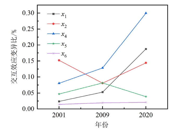
图9 不同时期主要驱动因子交互效应比变化图
Figure 9 Variation diagram of main driver IEVR in different periods
| [1] |
ABSON D J, DOUGILL A J, STRINGER L C, 2012. Using principal component analysis for information-rich socio-ecological vulnerability mapping in Southern Africa[J]. Applied Geography, 35(1-2): 515-524.
DOI URL |
| [2] |
DENG X D, LIU Y, GAO F, et al., 2021. Spatial distribution and mechanism of urban occupation mixture in Guangzhou: An optimized Geodetector-based index to compare individual and interactive effects[J]. ISPRS International Journal of Geo-Information, 10(10): 659.
DOI URL |
| [3] |
DUAN S, HAN F, LI F et al., 2022. Spatial evaluation of the ecological value importance of national park in Yarlung Tsangpo Grand Canyon[J]. Journal of Environmental Management, 320:115943.
DOI URL |
| [4] |
KANG H, TAO W D, CHANG Y, et al., 2018. A feasible method for the division of ecological vulnerability and its driving forces in Southern Shaanxi[J]. Journal of Cleaner Production, 205: 619-628.
DOI URL |
| [5] |
LI S K, HE W X, WANG L, et al., 2023. Optimization of landscape pattern in China Luojiang Xiaoxi Basin based on landscape ecological risk assessment[J]. Ecological Indicators, 146(6): 109887.
DOI URL |
| [6] |
LIU Y G, WANG L, LU Y F, et al., 2023. Identification and optimization methods for delineating ecological red lines in Sichuan Province of southwest China[J]. Ecological Indicators, 146(4): 109786.
DOI URL |
| [7] |
NIU Q, YU L, JIE Q, et al., 2020. An urban eco-environmental sensitive areas assessment method based on variable weights combination[J]. Environment, Development and Sustainability, 22(3): 2069-2085.
DOI |
| [8] |
POLSKY C, NEFF R, YARNAL B, 2007. Building comparable global change vulnerability assessments: The vulnerability scoping diagram[J]. Global Environmental Change, 17(3-4):472-485.
DOI URL |
| [9] |
QIAO X Y, WANG W K, DUAN L, et al., 2020. Regional groundwater cycle patterns and renewal capacity assessment at the south edge of the Junggar Basin, China[J]. Environmental Earth Sciences, 79(13): 334. 1-334.14.
DOI |
| [10] | QU L, ZHU Q, ZHU C, et al., 2022. Monthly precipitation data set with 1 km resolution in China from 1960 to 2020 [Z]. Science Data Bank. |
| [11] |
REN D F, CAO A H, 2022. Analysis of the heterogeneity of landscape risk evolution and driving factors based on a combined GeoDa and Geodetector model[J]. Ecological Indicators, 144(10): 109568.
DOI URL |
| [12] |
REZAEISABZEVAR Y, BAZARGAN A, ZOHOURIAN B, 2020. Landfill site selection using multi criteria decision making: Influential factors for comparing locations[J]. Journal of Environmental Sciences, 93: 170-184.
DOI PMID |
| [13] |
WANG S Y, LIU J S, YANG C J, 2008. Eco-environmental vulnerability evaluation in the Yellow River Basin, China[J]. Pedosphere, 18(2): 171-182.
DOI URL |
| [14] |
WANYAMA D, KAR B, MOORE N J, 2021. Quantitative multi-factor characterization of eco-environmental vulnerability in the Mount Elgon ecosystem[J]. GIScience and Remote Sensing, 58(8): 1571-1592.
DOI URL |
| [15] | WILLIAMS L R R, KAPUSTKA L A, 2000. Ecosystem vulnerability: A complex interface with technical components-editorial[J]. Environmental toxicology and chemistry, 19(4): 1055-1058. |
| [16] |
YANG J, HUANG X, 2021. The 30 m annual land cover dataset and its dynamics in China from 1990 to 2019[J]. Earth System Science Data, 13(8): 3907-3925.
DOI URL |
| [17] | 陈小平, 杨素香, 何建社, 等, 2014. 岷江上游干旱河谷区生态环境现状及恢复对策研究[J]. 四川林业科技, 35(2): 62-65. |
| CHEN X P, YANG S X, HE J S, et al., 2014. The present situation and recovery strategy of ecological environments in the dry valleys in the upper reaches of the Minjiang River area[J]. Journal of Sichuan Forestry Science and Technology, 35(2): 62-65. | |
| [18] |
程欢, 宫渊波, 吴强, 等, 2018. 川西亚高山/高山典型土壤类型有机碳、氮、磷含量及其生态化学计量特征[J]. 自然资源学报, 33(1): 161-172.
DOI |
|
CHENG H, GONG Y B, WU Q, et al., 2018. Content and ecological stoichiometry characteristics of organic carbon, Nitrogen and phosphorus of typical soils in Sub-alpine/Alpine Mountain of Western Sichuan[J]. Journal of Natural Resources, 33(1): 161-172.
DOI |
|
| [19] | 范建容, 杨超, 包维楷, 等, 2022. 西南干旱河谷范围数据 [Z]. 山地科学数据中心. |
| FAN J R, YANG C, BAO W K, et al., 2022. Distribution scope and district statistical analysis of dry valleys in southwest China [Z]. Mountain Science Data Center. | |
| [20] | 李平星, 陈诚, 2014. 基于VSD模型的经济发达地区生态脆弱性评价——以太湖流域为例[J]. 生态环境学报, 23(2): 237-243. |
| LI P X, CHEN C, 2014. Ecological vulnerability assessment of economic developed region based on VSD model: The case of Taihu Basin[J]. Ecology and Environmental Sciences, 23(2): 237-243. | |
| [21] | 李志学, 莫文波, 周松林, 等, 2021. 空间主成分分析的城市生活便利度指数研究——以长沙市为例[J]. 测绘地理信息, 46(2): 110-115. |
| LI Z X, MO W B, ZHOU S L, et al., 2021. Urban life convenience index based on spatial principal component analysis: a case study of Changsha city[J]. Journal of Geomatics, 46(2): 110-115. | |
| [22] | 廖凯涛, 宋月君, 谢颂华, 等, 2022. 基于Google Earth Engine的江西省植被覆盖度时空变化特征分析[J]. 中国水土保持 (10): 64-67. |
| LIAO K T, SONG Y J, XIE S H, et al., 2022. Spatial and temporal variation characteristics of vegetation coverage in Jiangxi Province based on google earth engine[J]. Soil and Water Conservation in China (10): 64-67. | |
| [23] | 刘铁冬, 2014. 杂谷脑河流域近30年景观格局时空演变研究[J]. 水土保持研究, 21(3): 98-102. |
| LIU T D, 2014. Study on spatiotemporal evolution of landscape pattern of Zagunao River Basin in recent 30 years[J]. Research of Soil and Water Conservation, 21(3): 98-102. | |
| [24] | 彭守璋, 2022. 中国1 km逐月潜在蒸散发数据集(1901-2022)[Z]. 国家青藏高原科学数据中心. |
| PENG S Z, 2022. 1 km monthly potential evapotranspiration dataset in China (1901-2022)[Z]. National Tibetan Plateau Data Center. | |
| [25] | 师嘉祺, 余恩旭, 徐亚莉, 等, 2021. 气候变化下西南亚高山森林景观恢复效果模拟预测——以岷江杂谷脑河上游流域为例[J]. 应用与环境生物学报, 27(3): 716-724. |
| SHI J Q, YU E X, XU Y L, et al., 2021. Simulating the effects of forest landscape restoration under climate change in southwest subalpine forests in China: A case study in the upper Zagunao watershed of the Minjiang River Basin[J]. Bulletin of Soil and Water Conservation, 27(3): 716-724. | |
| [26] | 孙宇晴, 杨鑫, 郝利娜, 2021. 基于SRP模型的川藏线2010-2020年生态脆弱性时空分异与驱动机制研究[J]. 水土保持通报, 41(6): 201-208. |
| SUN Y Q, YANG X, HAO L N, 2021. Spatial and temporal differentiation and driving mechanism of ecological vulnerability along Sichuan-Tibet railway during 2010-2020 based on SRP model[J]. Bulletin of Soil and Water Conservation, 41(6): 201-208. | |
| [27] | 汤国安, 宋佳, 2006. 基于DEM坡度图制图中坡度分级方法的比较研究[J]. 水土保持学报, 20(2): 157-160. |
| TANG G A, SONG J, 2006. Comparison of slope classification methods in slope mapping from DEMs[J]. Journal of Soil and Water Conservation, 20(2): 157-160. | |
| [28] | 田鑫, 李瑞平, 王思楠, 等, 2020. 基于VSWI和TVDI差异的河套灌区沈乌灌域耕地灌溉面积遥感监测[J]. 灌溉排水学报, 39(8): 129-135. |
| TIAN X, LI R P, WANG S N, et al., 2020. Using remote sensing to estimate irrigation area in Shenwu region in Hetao irrigation district[J]. Journal of Irrigation and Drainage, 39(8): 129-135. | |
| [29] | 汪璇, 邓丽梅, 刘刚才, 等, 2022. 川西亚高山区域的水源涵养功能变化趋势[J]. 水土保持通报, 42(1): 303-307. |
| WANG X, DENG L M, LIU G C, et al., 2022. Change trend of water-holding function in alpine and subalpine regions of western Sichuan province[J]. Bulletin of Soil and Water Conservation, 42(1): 303-307. | |
| [30] | 王若飞, 鄢发斌, 张铁硬, 等, 2021. 崇州市地质灾害特点与发育规律[J]. 四川地质学报, 41(S1): 113-121. |
| WANG R F, YAN F B, ZHANG T Y, et al., 2021. Characteristics and development regularity of geohazards in Chongzhou, Chengdu[J]. Acta Geologica Sichuan, 41(S1): 113-121. | |
| [31] | 魏健美, 李常斌, 武磊, 等, 2021. 基于USLE的甘南川西北土壤侵蚀研究[J]. 水土保持学报, 35(2): 31-37. |
| WEI J M, LI C B, WU L, et al., 2021. Study on soil erosion in northwestern Sichuan and southern Gansu (NSSG) based on USLE[J]. Journal of Soil and Water Conservation, 35(2): 31-37. | |
| [32] | 吴宁, 卢涛, 罗鹏, 等, 2008. 地震对山地生态系统的影响——以5•12汶川大地震为例[J]. 生态学报, 28(12): 5810-5819. |
| WU N, LU T, LUO P, et al., 2008. A review of the impacts of earthquake on mountain ecosystems: Taking 5•12 Wenchuan earthquake as an example[J]. Acta Ecologica Sinica, 28(12): 5810-5819. | |
| [33] | 肖桐, 王军邦, 陈卓奇, 2010. 三江源地区基于净初级生产力的草地生态系统脆弱性特征[J]. 资源科学, 32(2): 323-330. |
| XU T, WANG J B, CHEN Z Q, 2010. Vulnerability of grassland ecosystems in the Sanjiangyuan region based on NPP[J]. Resources Science, 32(2): 323-330. | |
| [34] | 杨渺, 江腊海, 侯鹏, 等, 2020. “5•12” 汶川地震极重灾区灾后十年生态恢复状况评估[J]. 长江流域资源与环境, 29(11): 2541-2550. |
| YANG M, JIANG L H, HOU P, et al., 2020. Evaluation of ecological restoration 10 years after the “5•12” Wenchuan earthquake[J]. Resources and Environment in the Yangtze Basin, 29(11): 2541-2550. | |
| [35] | 姚昆, 周兵, 何磊, 等, 2020. 岷江上游地区生态环境脆弱性变化研究[J]. 河南理工大学学报(自然科学版), 39(6): 78-87. |
| YAO K, ZHOU B, HE L, et al., 2020. Study on the change of eco-environmental vulnerability in the upper reaches of Minjiang River[J]. Journal of Henan Polytechnic University (Natural Science), 39(6): 78-87. | |
| [36] | 余恩旭, 张明芳, 蒋志魏, 等, 2023. 岷江上游土壤侵蚀时空演变特征及其成因分析[J]. 水土保持研究, 30(1): 1-10, 17. |
| YU E X, ZHANG M F, JIANG Z W, et al., 2023. Spatiotemporal dynamics of soil erosion and associated influencing factors in the upper Minjiang River watershed[J]. Research of Soil and Water Conservation, 30(1): 1-10, 17. |
| [1] | 田成诗, 孙瑞欣. 长江经济带市域生态环境质量空间分异与影响因素分析——基于三生空间的土地利用转型[J]. 生态环境学报, 2023, 32(7): 1173-1184. |
| [2] | 王琳, 卫伟. 黄土高原典型县域生态系统服务变化特征及驱动因素[J]. 生态环境学报, 2023, 32(6): 1140-1148. |
| [3] | 李建辉, 党争, 陈琳. 黄河几字弯都市圈PM2.5时空特征及影响因素分析[J]. 生态环境学报, 2023, 32(4): 697-705. |
| [4] | 王成武, 罗俊杰, 唐鸿湖. 基于InVEST模型的太行山沿线地区生态系统碳储量时空分异驱动力分析[J]. 生态环境学报, 2023, 32(2): 215-225. |
| [5] | 叶深, 王鹏, 黄祎, 折远洋, 丁明军. 长三角城市群城市空间形态对PM2.5与O3污染空间异质性特征的影响研究[J]. 生态环境学报, 2023, 32(10): 1771-1784. |
| [6] | 付蓉, 武新梅, 陈斌. 城市地表温度空间分异及驱动因子差异性分析——以合肥市为例[J]. 生态环境学报, 2023, 32(1): 110-122. |
| [7] | 陈文裕, 夏丽华, 徐国良, 余世钦, 陈行, 陈金凤. 2000—2020年珠江流域NDVI动态变化及影响因素研究[J]. 生态环境学报, 2022, 31(7): 1306-1316. |
| [8] | 李梦华, 韩颖娟, 赵慧, 王云霞. 基于地理探测器的宁夏植被覆盖度时空变化特征及其驱动因子分析[J]. 生态环境学报, 2022, 31(7): 1317-1325. |
| [9] | 高思琦, 董国涛, 蒋晓辉, 聂桐, 郭欣伟, 党素珍, 李心宇, 李昊洋. 黄河源植被覆盖度变化及空间分布自然驱动力分析[J]. 生态环境学报, 2022, 31(3): 429-439. |
| [10] | 赵锐, 詹梨苹, 周亮, 张军科. 地理探测联合地理加权岭回归的PM2.5驱动因素分析[J]. 生态环境学报, 2022, 31(2): 307-317. |
| [11] | 杨艳, 周德成, 宫兆宁, 刘子源, 张良侠. 基于植被生产力的黄土高原地区生态脆弱性及其控制因子分析[J]. 生态环境学报, 2022, 31(10): 1951-1958. |
| [12] | 聂桐, 董国涛, 蒋晓辉, 郭欣伟, 党素珍, 郑嘉昊, 李立缠, 王江. 榆林地区植被时空分异特征及其影响因素研究[J]. 生态环境学报, 2022, 31(1): 26-36. |
| [13] | 王金杰, 赵安周, 胡小枫. 京津冀植被净初级生产力时空分布及自然驱动因子分析[J]. 生态环境学报, 2021, 30(6): 1158-1167. |
| [14] | 张军, 高煜, 王国兰, 金梓函, 杨明航. 典型河谷城市土壤重金属含量空间分异及其影响因素[J]. 生态环境学报, 2021, 30(6): 1276-1285. |
| [15] | 王丽霞, 史园莉, 张宏伟, 毕晓玲, 申文明, 马万栋. 2000—2020年北方农牧交错区植被生态功能变化及驱动因子分析[J]. 生态环境学报, 2021, 30(10): 1990-1998. |
| 阅读次数 | ||||||
|
全文 |
|
|||||
|
摘要 |
|
|||||