生态环境学报 ›› 2022, Vol. 31 ›› Issue (11): 2198-2205.DOI: 10.16258/j.cnki.1674-5906.2022.11.011
张楷悦1( ), 刘增辉1, 王颜昊1, 王敬宽1, 崔德杰1, 柳新伟1,2,3,*()
收稿日期:2022-05-12
出版日期:2022-11-18
发布日期:2022-12-22
通讯作者:
*柳新伟(1976年生),男,副教授,博士,主要从事农业生态学研究。E-mail: sdxw@163.com作者简介:张楷悦(1998年生),女,硕士研究生,主要从事农业资源与环境方面研究。E-mail: 1749169204@qq.com
基金资助:
ZHANG Kaiyue1(), LIU Zhenghui1, WANG Yanhao1, WANG Jingkuan1, CUI Dejie1, LIU Xinwei1,2,3,*()
Received:2022-05-12
Online:2022-11-18
Published:2022-12-22
摘要:
黄河三角洲自然保护区在经济和生态上的作用越来越重要,该地区的生态环境也不断发生着变化。为了解黄河三角洲国家级自然保护区内土壤PAHs的含量、分布及风险状况,更好地保护和治理环境,在保护区不同功能区内设置71个点位,采集0-10 cm土壤测定16种优控PAHs的含量并结合效应区间低、中值法和各PAHs单体致癌斜率因子参数评估法评价其生态风险和健康风险,探究土壤PAHs的空间分布状况。结果表明:研究区域PAHs污染水平相对较低,16种优控PAHs的检出率为100%,其含量介于10.92-125.98 ng·g-1,远低于效应区间低值,潜在生态风险水平极低。利用各PAHs单体致癌斜率因子参数进行健康风险评价,结果显示区域内成人和儿童的致癌风险值为1.14×10⁻⁶-1.23×10⁻⁶,略大于健康管控值(1.0×10⁻⁶),表明存在潜在致癌风险。利用Kriging插值法分析空间格局,PAHs的块基比为0.59,为中等空间相关性,呈现北高南低的趋势;而健康风险值的块基比为0.88>0.75,空间相关性弱,其中南部地区的健康风险最低。研究区域PAHs污染水平相对较低,潜在生态风险水平极低,但存在潜在致癌风险。因此要注意对河三角洲自然保护区PAHs致癌风险的监测。结合空间分布图可以看出PAHs含量和PAHs健康风险值空间分布特征相似,说明PAHs的致癌风险与其含量呈正比关系。该研究对于黄河三角洲国家级自然保护区生态环境保护和治理具有重要的理论意义。
中图分类号:
张楷悦, 刘增辉, 王颜昊, 王敬宽, 崔德杰, 柳新伟. 黄河三角洲自然保护区土壤PAHs的风险评估和空间特征[J]. 生态环境学报, 2022, 31(11): 2198-2205.
ZHANG Kaiyue, LIU Zhenghui, WANG Yanhao, WANG Jingkuan, CUI Dejie, LIU Xinwei. Risk Assessment and Spatial Characteristics of PAHs in Soils in the Yellow River Delta Nature Reserve[J]. Ecology and Environment, 2022, 31(11): 2198-2205.
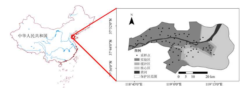
图1 土壤采样点位置图
Figure 1 Location map of soil sampling site
| 参数 Parameters | 成人 Adult | 儿童 Child |
|---|---|---|
| 皮肤表面土壤黏附系数 Coefficient of skin surface soil adhesion(SSAR)/ (mg·cm-1) | 0.07 | 0.2 |
| 每日空气呼吸量 Daily air respiration (DAIR)/(m3·d-1) | 14.5 | 7.5 |
| 每日摄入土壤量 Daily soil intake (OSIR)/(mg·d-1) | 100 | 200 |
| 暴露皮肤表面积 Expose skin surface area(SAE)/cm2 | 5074.89 | 2447.56 |
| 暴露周期 Exposure day (ED)/a | 24 | 6 |
| 平均体质量 Average mass (mb)/kg | 56.8 | 15.9 |
| 室内空气中来自土壤颗粒物占比 Proportion of particulate matter from soil in indoor air (fspo) | 0.8 | |
| 室外空气中来自土壤颗粒物占比 Proportion of particulate matter from soil in the outdoor air (fsip) | 0.5 | |
| 吸入土壤颗粒物在体内滞留比例 Proportion of inhaled soil particles retained in the body (PIAF) | 0.75 | |
| 空气可吸入浮颗粒物含量 Inhalable particulate matter content in air (PM10)/ (mg·m-3) | 0.15 | |
| 口腔摄入吸收效率因子 Oral absorption efficiency factor (ABSo) | 1 | |
| 皮肤接触吸收效率因子 Skin contact absorption efficiency factor (ABSd) | 0.13 | |
| 致癌效应平均时间 Average time carcinogenic effect (ANca)/d | 26280 | |
| 参考计量分配系数 Refer to the metering partition factor (SAF) | 0.2 | |
| 每日皮肤接触频率 Frequency of daily skin contact (Ev)/(time·d-1) | 1 | |
| 室外暴露频率 Exposure frequency outdoor (EFO)/(d·a-1) | 87.5 | |
| 室内暴露频率· Exposure frequency indoor (EFI)/(d·a-1) | 262.5 | |
| 暴露频率 Exposure frequency (EF)/(d·a-1) | 350 | |
| 人均寿命 Life expectancy (AT) | 74.83×365 | |
表1 致癌与非致癌风险计算参数取值
Table 1 Value of calculated parameters of carcinogenic and non-carcinogenic risks
| 参数 Parameters | 成人 Adult | 儿童 Child |
|---|---|---|
| 皮肤表面土壤黏附系数 Coefficient of skin surface soil adhesion(SSAR)/ (mg·cm-1) | 0.07 | 0.2 |
| 每日空气呼吸量 Daily air respiration (DAIR)/(m3·d-1) | 14.5 | 7.5 |
| 每日摄入土壤量 Daily soil intake (OSIR)/(mg·d-1) | 100 | 200 |
| 暴露皮肤表面积 Expose skin surface area(SAE)/cm2 | 5074.89 | 2447.56 |
| 暴露周期 Exposure day (ED)/a | 24 | 6 |
| 平均体质量 Average mass (mb)/kg | 56.8 | 15.9 |
| 室内空气中来自土壤颗粒物占比 Proportion of particulate matter from soil in indoor air (fspo) | 0.8 | |
| 室外空气中来自土壤颗粒物占比 Proportion of particulate matter from soil in the outdoor air (fsip) | 0.5 | |
| 吸入土壤颗粒物在体内滞留比例 Proportion of inhaled soil particles retained in the body (PIAF) | 0.75 | |
| 空气可吸入浮颗粒物含量 Inhalable particulate matter content in air (PM10)/ (mg·m-3) | 0.15 | |
| 口腔摄入吸收效率因子 Oral absorption efficiency factor (ABSo) | 1 | |
| 皮肤接触吸收效率因子 Skin contact absorption efficiency factor (ABSd) | 0.13 | |
| 致癌效应平均时间 Average time carcinogenic effect (ANca)/d | 26280 | |
| 参考计量分配系数 Refer to the metering partition factor (SAF) | 0.2 | |
| 每日皮肤接触频率 Frequency of daily skin contact (Ev)/(time·d-1) | 1 | |
| 室外暴露频率 Exposure frequency outdoor (EFO)/(d·a-1) | 87.5 | |
| 室内暴露频率· Exposure frequency indoor (EFI)/(d·a-1) | 262.5 | |
| 暴露频率 Exposure frequency (EF)/(d·a-1) | 350 | |
| 人均寿命 Life expectancy (AT) | 74.83×365 | |
| PAHs种类 Types of PAHs | PAHs的含量范围 Content range of PAHs/ (ng·g-1) | 中位数 The median/ (ng·g-1) | 平均值 The average/ (ng·g-1) | 检出率 Detection rate/ % | 变异系数 Coefficient of variation | 生态风险限值 Ecological risk limit | |
|---|---|---|---|---|---|---|---|
| ERL | ERM | ||||||
| Nap | nd-45.90 | 9.88 | 16.02±10.58 | 95.77 | 0.79 | 160 | 2100 |
| Ace | 0.75-19.30 | 4.91 | 7.61±3.77 | 100.00 | 0.66 | 44 | 640 |
| Acy | nd-3.39 | 1.52 | 2.76±0.66 | 88.73 | 0.46 | 16 | 500 |
| Fl | 0.24-9.39 | 1.87 | 3.81±1.21 | 100.00 | 0.51 | 19 | 540 |
| Phe | 1.32-33.35 | 8.06 | 10.61±6.61 | 100.00 | 0.68 | 240 | 1500 |
| Ant | 0.30-5.74 | 2.06 | 3.77±1.12 | 100.00 | 0.56 | 85.3 | 1100 |
| Flu | 0.44-18.50 | 9.61 | 11.26±4.04 | 100.00 | 0.43 | 600 | 5100 |
| Pyr | nd-52.08 | 4.30 | 10.08±8.60 | 100.00 | 1.24 | 665 | 2600 |
| BaA | nd-2.40 | 0.00 | 0.71±0.51 | 97.18 | 1.82 | 261 | 1600 |
| Chr | nd-17.89 | 0.00 | 1.78±2.90 | 33.80 | 3.07 | 384 | 2800 |
| BbF | 0.03-9.25 | 1.22 | 3.34±1.89 | 26.76 | 1.01 | - | - |
| BkF | 0.03-4.49 | 0.68 | 2.36±0.65 | 100.00 | 0.79 | - | - |
| BaP | nd-10.54 | 0.52 | 2.66±1.47 | 100.00 | 1.44 | 430 | 1600 |
| DBA | nd-1.17 | 0.00 | 0.62±0.27 | 94.37 | 2.22 | 63.4 | 260 |
| BgP | nd-8.60 | 2.49 | 4.74±2.40 | 30.99 | 0.81 | - | - |
| InP | nd-2.75 | 0.42 | 2.16±0.55 | 97.18 | 0.94 | - | - |
| 总量 The total | 10.92-125.98 | - | 61.91±23.60 | - | 0.40 | 4022 | 40792 |
表2 土壤中PAHs的生态风险评价指标
Table 2 Ecological risk assessment index of PAHs in soil
| PAHs种类 Types of PAHs | PAHs的含量范围 Content range of PAHs/ (ng·g-1) | 中位数 The median/ (ng·g-1) | 平均值 The average/ (ng·g-1) | 检出率 Detection rate/ % | 变异系数 Coefficient of variation | 生态风险限值 Ecological risk limit | |
|---|---|---|---|---|---|---|---|
| ERL | ERM | ||||||
| Nap | nd-45.90 | 9.88 | 16.02±10.58 | 95.77 | 0.79 | 160 | 2100 |
| Ace | 0.75-19.30 | 4.91 | 7.61±3.77 | 100.00 | 0.66 | 44 | 640 |
| Acy | nd-3.39 | 1.52 | 2.76±0.66 | 88.73 | 0.46 | 16 | 500 |
| Fl | 0.24-9.39 | 1.87 | 3.81±1.21 | 100.00 | 0.51 | 19 | 540 |
| Phe | 1.32-33.35 | 8.06 | 10.61±6.61 | 100.00 | 0.68 | 240 | 1500 |
| Ant | 0.30-5.74 | 2.06 | 3.77±1.12 | 100.00 | 0.56 | 85.3 | 1100 |
| Flu | 0.44-18.50 | 9.61 | 11.26±4.04 | 100.00 | 0.43 | 600 | 5100 |
| Pyr | nd-52.08 | 4.30 | 10.08±8.60 | 100.00 | 1.24 | 665 | 2600 |
| BaA | nd-2.40 | 0.00 | 0.71±0.51 | 97.18 | 1.82 | 261 | 1600 |
| Chr | nd-17.89 | 0.00 | 1.78±2.90 | 33.80 | 3.07 | 384 | 2800 |
| BbF | 0.03-9.25 | 1.22 | 3.34±1.89 | 26.76 | 1.01 | - | - |
| BkF | 0.03-4.49 | 0.68 | 2.36±0.65 | 100.00 | 0.79 | - | - |
| BaP | nd-10.54 | 0.52 | 2.66±1.47 | 100.00 | 1.44 | 430 | 1600 |
| DBA | nd-1.17 | 0.00 | 0.62±0.27 | 94.37 | 2.22 | 63.4 | 260 |
| BgP | nd-8.60 | 2.49 | 4.74±2.40 | 30.99 | 0.81 | - | - |
| InP | nd-2.75 | 0.42 | 2.16±0.55 | 97.18 | 0.94 | - | - |
| 总量 The total | 10.92-125.98 | - | 61.91±23.60 | - | 0.40 | 4022 | 40792 |
| 项目 | Nap | Ace | Acy | FI | Phe | Ant | Flu | Pyr | BaA | Chr | BbF | BkF | BaP | DBA | BgP | InP |
|---|---|---|---|---|---|---|---|---|---|---|---|---|---|---|---|---|
| Nap | 1 | |||||||||||||||
| Ace | 0.312** | 1 | ||||||||||||||
| Acy | 0.011 | 0.095 | 1 | |||||||||||||
| FI | 0.072 | 0.085 | -0.095 | 1 | ||||||||||||
| Phe | 0.346** | -0.066 | 0.125 | 0.299* | 1 | |||||||||||
| Ant | 0.485** | 0.348** | -0.221 | 0.123 | -0.025 | 1 | ||||||||||
| Flu | 0.433** | 0.007 | -0.035 | 0.064 | 0.229 | 0.606** | 1 | |||||||||
| Pyr | 0.268* | -0.024 | -0.425** | 0.433** | -0.01 | 0.354** | 0.333** | 1 | ||||||||
| BaA | -0.121 | -0.21 | 0.234* | 0.217 | 0.193 | -0.508** | -0.198 | -0.208 | 1 | |||||||
| Chr | -0.114 | 0 | 0.081 | -0.163 | -0.094 | 0.025 | 0.167 | -0.039 | -0.144 | 1 | ||||||
| BbF | -0.029 | -0.097 | 0.053 | -0.02 | -0.132 | -0.007 | 0.13 | -0.149 | 0.288* | 0.07 | 1 | |||||
| BkF | 0.223 | 0.042 | -0.267* | 0.002 | -0.047 | 0.236* | 0.277* | 0.317** | 0.038 | -0.057 | 0.608** | 1 | ||||
| BaP | 0.387** | 0.008 | -0.17 | -0.098 | 0.145 | 0.281* | 0.375** | 0.289* | -0.161 | -0.08 | 0.091 | 0.391** | 1 | |||
| DBA | 0.013 | 0.015 | -0.145 | -0.062 | 0.321** | 0.044 | 0.146 | 0.026 | -0.144 | 0.174 | -0.136 | 0.081 | 0.224 | 1 | ||
| BgP | 0.168 | 0.06 | -0.032 | -0.147 | -0.043 | 0.443** | 0.417** | 0.12 | -0.422** | 0.083 | -0.021 | 0.055 | 0.02 | -0.02 | 1 | |
| InP | 0.166 | 0.118 | 0.001 | -0.189 | -0.137 | 0.237* | 0.237* | 0.059 | -0.287* | 0.139 | -0.138 | -0.029 | 0.031 | -0.06 | 0.19 | 1 |
表3 土壤PAHs相关性矩阵
Table 3 Correlation matrix of soil PAHs
| 项目 | Nap | Ace | Acy | FI | Phe | Ant | Flu | Pyr | BaA | Chr | BbF | BkF | BaP | DBA | BgP | InP |
|---|---|---|---|---|---|---|---|---|---|---|---|---|---|---|---|---|
| Nap | 1 | |||||||||||||||
| Ace | 0.312** | 1 | ||||||||||||||
| Acy | 0.011 | 0.095 | 1 | |||||||||||||
| FI | 0.072 | 0.085 | -0.095 | 1 | ||||||||||||
| Phe | 0.346** | -0.066 | 0.125 | 0.299* | 1 | |||||||||||
| Ant | 0.485** | 0.348** | -0.221 | 0.123 | -0.025 | 1 | ||||||||||
| Flu | 0.433** | 0.007 | -0.035 | 0.064 | 0.229 | 0.606** | 1 | |||||||||
| Pyr | 0.268* | -0.024 | -0.425** | 0.433** | -0.01 | 0.354** | 0.333** | 1 | ||||||||
| BaA | -0.121 | -0.21 | 0.234* | 0.217 | 0.193 | -0.508** | -0.198 | -0.208 | 1 | |||||||
| Chr | -0.114 | 0 | 0.081 | -0.163 | -0.094 | 0.025 | 0.167 | -0.039 | -0.144 | 1 | ||||||
| BbF | -0.029 | -0.097 | 0.053 | -0.02 | -0.132 | -0.007 | 0.13 | -0.149 | 0.288* | 0.07 | 1 | |||||
| BkF | 0.223 | 0.042 | -0.267* | 0.002 | -0.047 | 0.236* | 0.277* | 0.317** | 0.038 | -0.057 | 0.608** | 1 | ||||
| BaP | 0.387** | 0.008 | -0.17 | -0.098 | 0.145 | 0.281* | 0.375** | 0.289* | -0.161 | -0.08 | 0.091 | 0.391** | 1 | |||
| DBA | 0.013 | 0.015 | -0.145 | -0.062 | 0.321** | 0.044 | 0.146 | 0.026 | -0.144 | 0.174 | -0.136 | 0.081 | 0.224 | 1 | ||
| BgP | 0.168 | 0.06 | -0.032 | -0.147 | -0.043 | 0.443** | 0.417** | 0.12 | -0.422** | 0.083 | -0.021 | 0.055 | 0.02 | -0.02 | 1 | |
| InP | 0.166 | 0.118 | 0.001 | -0.189 | -0.137 | 0.237* | 0.237* | 0.059 | -0.287* | 0.139 | -0.138 | -0.029 | 0.031 | -0.06 | 0.19 | 1 |
| PAHs | 人群 The crowd | Po-Max | 百分比 The percentage/ % | Pd-Max | 百分比 The percentage/ % | Ri-p-Max | 百分比 The percentage/ % | PT-Max | 百分比 The percentage/ % | 单体贡献率 Unit contribution rate/% |
|---|---|---|---|---|---|---|---|---|---|---|
| Nap | 成人 Adult | 1.29×10⁻⁸ | 76.79 | 1.29×10⁻⁸ | 76.79 | 1.45 | ||||
| 儿童 Children | 3.91×10⁻⁹ | 23.21 | 3.91×10⁻⁹ | 23.21 | 1.29 | |||||
| 人群 The crowd | 1.68×10⁻⁸ | 100.00 | 1.68×10⁻⁸ | 100.00 | 1.37 | |||||
| Acy | 成人 Adult | 1.25×10⁻⁸ | 46.12 | 1.98×10⁻⁸ | 55.40 | 9.56×10⁻¹⁰ | 76.79 | 3.32×10⁻⁸ | 51.88 | 3.93 |
| 儿童 Children | 1.46×10⁻⁸ | 53.88 | 1.59×10⁻⁸ | 44.60 | 2.89×10⁻¹⁰ | 23.21 | 3.08×10⁻⁸ | 48.12 | 3.93 | |
| 人群 The crowd | 2.71×10⁻⁸ | 100.00 | 3.57×10⁻⁸ | 100.00 | 1.25×10⁻⁹ | 100.00 | 6.40×10⁻⁸ | 100.00 | 3.93 | |
| Phe | 成人 Adult | 1.23×10⁻⁷ | 46.07 | 1.94×10⁻⁷ | 55.27 | 9.40×10⁻⁹ | 76.80 | 3.27×10⁻⁷ | 51.90 | 35.74 |
| 儿童 Children | 1.44×10⁻⁷ | 53.93 | 1.57×10⁻⁷ | 44.73 | 2.84×10⁻⁹ | 23.20 | 3.03×10⁻⁷ | 48.10 | 35.72 | |
| 人群 The crowd | 2.67×10⁻⁷ | 100.00 | 3.51×10⁻⁷ | 100.00 | 1.22×10⁻⁸ | 100.00 | 6.30×10⁻⁷ | 100.00 | 35.73 | |
| BaA | 成人 Adult | 8.85×10⁻⁹ | 46.10 | 1.40×10⁻⁸ | 55.34 | 6.77×10⁻¹⁰ | 76.84 | 2.35×10⁻⁸ | 51.88 | 2.75 |
| 儿童 Children | 1.03×10⁻⁸ | 53.90 | 1.13×10⁻⁸ | 44.66 | 2.04×10⁻¹⁰ | 23.16 | 2.18×10⁻⁸ | 48.12 | 2.73 | |
| 人群 The crowd | 1.92×10⁻⁸ | 100.00 | 2.53×10⁻⁸ | 100.00 | 8.81×10⁻¹⁰ | 100.00 | 4.53×10⁻⁸ | 100.00 | 2.74 | |
| Chr | 成人 Adult | 6.60×10⁻⁸ | 46.12 | 1.04×10⁻⁷ | 55.32 | 5.04×10⁻⁹ | 76.83 | 1.75×10⁻⁷ | 51.78 | 18.97 |
| 儿童 Children | 7.71×10⁻⁸ | 53.88 | 8.40×10⁻⁸ | 44.68 | 1.52×10⁻⁹ | 23.17 | 1.63×10⁻⁷ | 48.22 | 18.95 | |
| 人群 The crowd | 1.43×10⁻⁷ | 100.00 | 1.88×10⁻⁷ | 100.00 | 6.56×10⁻⁹ | 100.00 | 3.38×10⁻⁷ | 100.00 | 18.96 | |
| BbF | 成人 Adult | 3.41×10⁻⁸ | 46.14 | 5.39×10⁻⁸ | 55.40 | 2.61×10⁻⁹ | 76.76 | 9.06×10⁻⁸ | 51.86 | 9.81 |
| 儿童 Children | 3.98×10⁻⁸ | 53.86 | 4.34×10⁻⁸ | 44.60 | 7.88×10⁻¹⁰ | 23.24 | 8.41×10⁻⁸ | 48.14 | 9.81 | |
| 人群 The crowd | 7.39×10⁻⁸ | 100.00 | 9.73×10⁻⁸ | 100.00 | 3.40×10⁻⁹ | 100.00 | 1.75×10⁻⁷ | 100.00 | 9.81 | |
| BkF | 成人 Adult | 1.66×10⁻⁸ | 46.24 | 2.62×10⁻⁸ | 55.40 | 1.27×10⁻⁹ | 76.97 | 4.40×10⁻⁸ | 51.89 | 4.77 |
| 儿童 Children | 1.93×10⁻⁸ | 53.76 | 2.11×10⁻⁸ | 44.60 | 3.83×10⁻¹⁰ | 23.03 | 4.08×10⁻⁸ | 48.11 | 4.77 | |
| 人群 The crowd | 3.59×10⁻⁸ | 100.00 | 4.73×10⁻⁸ | 100.00 | 1.65×10⁻⁹ | 100.00 | 8.48×10⁻⁸ | 100.00 | 4.77 | |
| BaP | 成人 Adult | 3.89×10⁻⁸ | 46.14 | 6.15×10⁻⁸ | 55.41 | 2.97×10⁻⁹ | 76.74 | 1.03×10⁻⁷ | 51.78 | 11.16 |
| 儿童 Children | 4.54×10⁻⁸ | 53.86 | 4.95×10⁻⁸ | 44.59 | 8.98×10⁻¹⁰ | 23.26 | 9.58×10⁻⁸ | 48.22 | 11.16 | |
| 人群 The crowd | 8.43×10⁻⁸ | 100.00 | 1.11×10⁻⁷ | 100.00 | 3.87×10⁻⁹ | 100.00 | 1.99×10⁻⁷ | 100.00 | 11.16 | |
| InP | 成人 Adult | 3.17×10⁻⁸ | 46.14 | 5.01×10⁻⁸ | 55.36 | 2.42×10⁻⁹ | 76.58 | 8.43×10⁻⁸ | 51.91 | 9.13 |
| 儿童 Children | 3.70×10⁻⁸ | 53.86 | 4.04×10⁻⁸ | 44.64 | 7.32×10⁻¹⁰ | 23.42 | 7.81×10⁻⁸ | 48.19 | 9.13 | |
| 人群The crowd | 6.87×10⁻⁸ | 100.00 | 9.05×10⁻⁸ | 100.00 | 3.16×10⁻⁹ | 100.00 | 1.62×10⁻⁷ | 100.00 | 9.19 | |
| BgP | 成人 Adult | 1.01×10⁻⁸ | 46.12 | 1.60×10⁻⁸ | 55.36 | 7.75×10⁻¹⁰ | 76.81 | 2.69×10⁻⁸ | 51.83 | 2.29 |
| 儿童 Children | 1.18×10⁻⁸ | 53.88 | 1.29×10⁻⁸ | 44.64 | 2.34×10⁻¹⁰ | 23.19 | 2.50×10⁻⁸ | 48.17 | 2.29 | |
| 人群 The crowd | 2.19×10⁻⁸ | 100.00 | 2.89×10⁻⁸ | 100.00 | 1.01×10⁻⁹ | 100.00 | 5.19×10⁻⁸ | 100.00 | 2.29 | |
| Totle | 成人 Adult | 4.64×10⁻⁷ | 46.08 | 7.35×10⁻⁷ | 55.43 | 3.55×10⁻⁸ | 76.84 | 1.23×10⁻⁶ | 51.90 | 100.00 |
| 儿童 Children | 5.43×10⁻⁷ | 53.92 | 5.91×10⁻⁷ | 44.57 | 1.07×10⁻⁸ | 23.16 | 1.14×10⁻⁶ | 48.10 | 100.00 | |
| 人群 The crowd | 1.01×10⁻⁶ | 100.00 | 1.33×10⁻⁶ | 100.00 | 4.62×10⁻⁸ | 100.00 | 2.37×10⁻⁶ | 100.00 | 100.00 |
表4 土壤PAHs对不同人群和暴露途径致癌风险的评价指标
Table 4 Evaluation indexes of carcinogenic risk of soil PAHs in different populations and exposure routes
| PAHs | 人群 The crowd | Po-Max | 百分比 The percentage/ % | Pd-Max | 百分比 The percentage/ % | Ri-p-Max | 百分比 The percentage/ % | PT-Max | 百分比 The percentage/ % | 单体贡献率 Unit contribution rate/% |
|---|---|---|---|---|---|---|---|---|---|---|
| Nap | 成人 Adult | 1.29×10⁻⁸ | 76.79 | 1.29×10⁻⁸ | 76.79 | 1.45 | ||||
| 儿童 Children | 3.91×10⁻⁹ | 23.21 | 3.91×10⁻⁹ | 23.21 | 1.29 | |||||
| 人群 The crowd | 1.68×10⁻⁸ | 100.00 | 1.68×10⁻⁸ | 100.00 | 1.37 | |||||
| Acy | 成人 Adult | 1.25×10⁻⁸ | 46.12 | 1.98×10⁻⁸ | 55.40 | 9.56×10⁻¹⁰ | 76.79 | 3.32×10⁻⁸ | 51.88 | 3.93 |
| 儿童 Children | 1.46×10⁻⁸ | 53.88 | 1.59×10⁻⁸ | 44.60 | 2.89×10⁻¹⁰ | 23.21 | 3.08×10⁻⁸ | 48.12 | 3.93 | |
| 人群 The crowd | 2.71×10⁻⁸ | 100.00 | 3.57×10⁻⁸ | 100.00 | 1.25×10⁻⁹ | 100.00 | 6.40×10⁻⁸ | 100.00 | 3.93 | |
| Phe | 成人 Adult | 1.23×10⁻⁷ | 46.07 | 1.94×10⁻⁷ | 55.27 | 9.40×10⁻⁹ | 76.80 | 3.27×10⁻⁷ | 51.90 | 35.74 |
| 儿童 Children | 1.44×10⁻⁷ | 53.93 | 1.57×10⁻⁷ | 44.73 | 2.84×10⁻⁹ | 23.20 | 3.03×10⁻⁷ | 48.10 | 35.72 | |
| 人群 The crowd | 2.67×10⁻⁷ | 100.00 | 3.51×10⁻⁷ | 100.00 | 1.22×10⁻⁸ | 100.00 | 6.30×10⁻⁷ | 100.00 | 35.73 | |
| BaA | 成人 Adult | 8.85×10⁻⁹ | 46.10 | 1.40×10⁻⁸ | 55.34 | 6.77×10⁻¹⁰ | 76.84 | 2.35×10⁻⁸ | 51.88 | 2.75 |
| 儿童 Children | 1.03×10⁻⁸ | 53.90 | 1.13×10⁻⁸ | 44.66 | 2.04×10⁻¹⁰ | 23.16 | 2.18×10⁻⁸ | 48.12 | 2.73 | |
| 人群 The crowd | 1.92×10⁻⁸ | 100.00 | 2.53×10⁻⁸ | 100.00 | 8.81×10⁻¹⁰ | 100.00 | 4.53×10⁻⁸ | 100.00 | 2.74 | |
| Chr | 成人 Adult | 6.60×10⁻⁸ | 46.12 | 1.04×10⁻⁷ | 55.32 | 5.04×10⁻⁹ | 76.83 | 1.75×10⁻⁷ | 51.78 | 18.97 |
| 儿童 Children | 7.71×10⁻⁸ | 53.88 | 8.40×10⁻⁸ | 44.68 | 1.52×10⁻⁹ | 23.17 | 1.63×10⁻⁷ | 48.22 | 18.95 | |
| 人群 The crowd | 1.43×10⁻⁷ | 100.00 | 1.88×10⁻⁷ | 100.00 | 6.56×10⁻⁹ | 100.00 | 3.38×10⁻⁷ | 100.00 | 18.96 | |
| BbF | 成人 Adult | 3.41×10⁻⁸ | 46.14 | 5.39×10⁻⁸ | 55.40 | 2.61×10⁻⁹ | 76.76 | 9.06×10⁻⁸ | 51.86 | 9.81 |
| 儿童 Children | 3.98×10⁻⁸ | 53.86 | 4.34×10⁻⁸ | 44.60 | 7.88×10⁻¹⁰ | 23.24 | 8.41×10⁻⁸ | 48.14 | 9.81 | |
| 人群 The crowd | 7.39×10⁻⁸ | 100.00 | 9.73×10⁻⁸ | 100.00 | 3.40×10⁻⁹ | 100.00 | 1.75×10⁻⁷ | 100.00 | 9.81 | |
| BkF | 成人 Adult | 1.66×10⁻⁸ | 46.24 | 2.62×10⁻⁸ | 55.40 | 1.27×10⁻⁹ | 76.97 | 4.40×10⁻⁸ | 51.89 | 4.77 |
| 儿童 Children | 1.93×10⁻⁸ | 53.76 | 2.11×10⁻⁸ | 44.60 | 3.83×10⁻¹⁰ | 23.03 | 4.08×10⁻⁸ | 48.11 | 4.77 | |
| 人群 The crowd | 3.59×10⁻⁸ | 100.00 | 4.73×10⁻⁸ | 100.00 | 1.65×10⁻⁹ | 100.00 | 8.48×10⁻⁸ | 100.00 | 4.77 | |
| BaP | 成人 Adult | 3.89×10⁻⁸ | 46.14 | 6.15×10⁻⁸ | 55.41 | 2.97×10⁻⁹ | 76.74 | 1.03×10⁻⁷ | 51.78 | 11.16 |
| 儿童 Children | 4.54×10⁻⁸ | 53.86 | 4.95×10⁻⁸ | 44.59 | 8.98×10⁻¹⁰ | 23.26 | 9.58×10⁻⁸ | 48.22 | 11.16 | |
| 人群 The crowd | 8.43×10⁻⁸ | 100.00 | 1.11×10⁻⁷ | 100.00 | 3.87×10⁻⁹ | 100.00 | 1.99×10⁻⁷ | 100.00 | 11.16 | |
| InP | 成人 Adult | 3.17×10⁻⁸ | 46.14 | 5.01×10⁻⁸ | 55.36 | 2.42×10⁻⁹ | 76.58 | 8.43×10⁻⁸ | 51.91 | 9.13 |
| 儿童 Children | 3.70×10⁻⁸ | 53.86 | 4.04×10⁻⁸ | 44.64 | 7.32×10⁻¹⁰ | 23.42 | 7.81×10⁻⁸ | 48.19 | 9.13 | |
| 人群The crowd | 6.87×10⁻⁸ | 100.00 | 9.05×10⁻⁸ | 100.00 | 3.16×10⁻⁹ | 100.00 | 1.62×10⁻⁷ | 100.00 | 9.19 | |
| BgP | 成人 Adult | 1.01×10⁻⁸ | 46.12 | 1.60×10⁻⁸ | 55.36 | 7.75×10⁻¹⁰ | 76.81 | 2.69×10⁻⁸ | 51.83 | 2.29 |
| 儿童 Children | 1.18×10⁻⁸ | 53.88 | 1.29×10⁻⁸ | 44.64 | 2.34×10⁻¹⁰ | 23.19 | 2.50×10⁻⁸ | 48.17 | 2.29 | |
| 人群 The crowd | 2.19×10⁻⁸ | 100.00 | 2.89×10⁻⁸ | 100.00 | 1.01×10⁻⁹ | 100.00 | 5.19×10⁻⁸ | 100.00 | 2.29 | |
| Totle | 成人 Adult | 4.64×10⁻⁷ | 46.08 | 7.35×10⁻⁷ | 55.43 | 3.55×10⁻⁸ | 76.84 | 1.23×10⁻⁶ | 51.90 | 100.00 |
| 儿童 Children | 5.43×10⁻⁷ | 53.92 | 5.91×10⁻⁷ | 44.57 | 1.07×10⁻⁸ | 23.16 | 1.14×10⁻⁶ | 48.10 | 100.00 | |
| 人群 The crowd | 1.01×10⁻⁶ | 100.00 | 1.33×10⁻⁶ | 100.00 | 4.62×10⁻⁸ | 100.00 | 2.37×10⁻⁶ | 100.00 | 100.00 |
| 项目 Item | 块金值 Nugget value | 基台值 Base stations values | 块基比 Block base than |
|---|---|---|---|
| 含量 Content | 380.5945 | 650.4506 | 0.5851 |
| 人群健康风险值 Population health risk value | 2.9121×10⁻¹² | 3.2965×10⁻¹² | 0.8834 |
表5 土壤PAHs相关半方差参数
Table 5 Related semi-variance parameters of soil PAHs
| 项目 Item | 块金值 Nugget value | 基台值 Base stations values | 块基比 Block base than |
|---|---|---|---|
| 含量 Content | 380.5945 | 650.4506 | 0.5851 |
| 人群健康风险值 Population health risk value | 2.9121×10⁻¹² | 3.2965×10⁻¹² | 0.8834 |
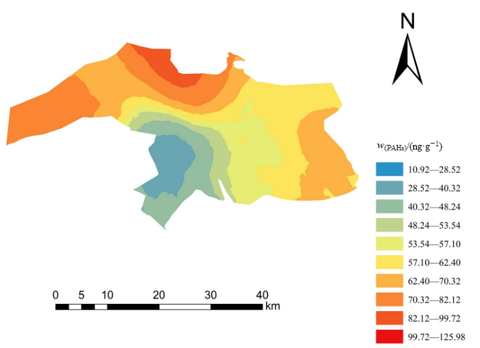
图2 土壤PAHs含量的空间分布
Figure 2 spatial distribution of PAHs content in soil
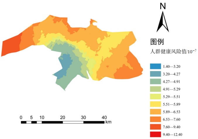
图3 土壤PAHs的人群健康风险值空间分布
Figure 3 Spatial distribution of population health risk values of soil PAHs
| [1] |
CHAI C, CHENG Q Q, WU J, et al., 2017. Contamination, source identification, and risk assessment of polycyclic aromatic hydrocarbons in the soils of vegetable greenhouses in Shandong[J]. Ecotoxicology and Environmental Safety, 142: 181-188.
DOI URL |
| [2] | JIANG Y F, YUAN L M, WEN H, et al., 2020. Distribution, composition, sources, and potential ecological risks of PAHs in the sediments of the Lanzhou reach of the Yellow River, China[J]. Bulletin of Environmental Contamination and Toxicology, 105(4): 23-27. |
| [3] |
LONG E R, MACDONALD D D, SMITH S L, et al., 1995. Incidence of adverse biological effects within ranges of chemical concentrations in marine and estuarine sediments[J]. Environmental Management, 19(1): 81-97.
DOI URL |
| [4] |
SHEN Q, WANG K Y, ZHANG W, et al., 2009. Characterization and sources of PAHs in an urban river system in Beijing, China[J]. Environmental Geochemistry and Health, 31(4): 453.
DOI PMID |
| [5] | TARAFDAR A, SINHA A, 2019. Health risk assessment and source study of PAHs from roadside soil dust of a heavy mining area in India[J]. Archives of Environmental & Occupational Health, 74(5): 252-262. |
| [6] |
VANE C H, KIM A W, BERIRO D J et al., 2014. Polycyclic Aromatic Hydrocarbons (PAHs) and Polychlorinated Biphenyls (PCB) in UrbanSoilsof Greater London, UK[J]. Applied Geochemistry, 51: 303-314.
DOI URL |
| [7] | ZHANG L L, HIROSHI M, WEI Y J, et al., 2020. PM2.5-bound polycyclic aromatic hydrocarbons and nitro-polycyclic aromatic hydrocarbons inside and outside a primary school classroom in Beijing: Concentration, composition and inhalation cancer risk[J]. Science of the Total Environment, 705(C): 45-50. |
| [8] | ZHAO X, QIU H R, ZHAO Y L, et al., 2015. Distribution of polycyclic aromatic hydrocarbons in surface water from the upper reach of the Yellow River, Northwestern China[J]. Environmental science and pollution research international, 22(9): 33-39. |
| [9] | 蔡杨, 李伟, 左雪燕, 等, 2021. 盐城滨海湿地土壤多环芳烃分布特征及影响因素[J]. 生态环境学报, 30(6): 1249-1259. |
| CAI Y, LI W, ZUO X Y, et al., 2021. Distribution characteristics and influencing factors of PAHs in Yancheng Coastal Wetland Soil[J]. Journal of Ecology and Environment, 30(6): 1249-1259. | |
| [10] | 高洪亮, 2021. 黄河三角洲背景点大气PM2.5中多环芳烃及其衍生物的污染特征和来源解析[D]. 济南: 山东大学: 1-90. |
| GAO H L, 2021. Pollution characteristics and source analysis of polycyclic aromatic hydrocarbons (PAHs) and their derivatives in PM2.5 at background points in the Yellow River Delta[D]. Ji’nan: Shandong University: 1-90. | |
| [11] | 高晓奇, 王学霞, 汪浩, 等, 2017. 黄河三角洲丰水期上覆水中PAHs分布、来源及生态风险研究[J]. 生态环境学报, 26(5): 831-836. |
| GAO X Q, WANG X X, WANG H, et al., 2017. Distribution, source and ecological risk assessment of polycyclic aromatic hydrocarbons in overlying water during flood seasons from the Yellow River Delta, China[J]. Journal of Ecology and Environment, 26(5): 831-836. | |
| [12] | 葛蔚, 程琪琪, 柴超, 等, 2017. 青岛市城郊蔬菜中多环芳烃污染特征和健康风险评估[J]. 环境科学学报, 37(12): 4772-4778. |
| GE W, CHENG Q Q, CHAI C, et al., 2017. Pollution characteristics and health risk assessment of polycyclic aromatic hydrocarbons in vegetables in the suburbs of Qingdao city[J]. Chinese Journal of Environmental Science, 37(12): 4772-4778. | |
| [13] | 虢新运, 2008. 黄河三角洲地区土壤中多环芳烃的污染状况及源解析研究[D]. 青岛: 中国海洋大学: 1-68. |
| GUO X Y, 2008. Pollution status and source analysis of polycyclic aromatic hydrocarbons in soil of Yellow River Delta[D]. Qingdao: Ocean University of China: 1-68. | |
| [14] | 韩玲, 高照琴, 白军红, 等, 2019. 城市化背景下珠江三角洲典型湿地土壤多环芳烃 (PAHs) 的含量、来源与污染风险评价[J]. 农业环境科学学报, 38(3): 609-617. |
| HAN L, GAO Z Q, BAI J H, et al., 2019. Soil polycyclic aromatic hydrocarbons (PAHs) content, sources and pollution risk assessment in typical wetlands of pearl River Delta under urbanization background[J]. Journal of Agro-Environment Science, 38(3): 609-617. | |
| [15] | 刘江生, 2009. 东北老工业基地浑蒲灌区土壤中多环芳烃污染特征、断代、溯源及风险评价研究[D]. 济南: 山东大学: 1-88. |
| LIU J S, 2009. Pollution characteristics, dating, traceability and risk assessment of polycyclic aromatic hydrocarbons in soil of Hunpu irrigation area in northeast China[D]. Ji’nan, Shandong University: 1-88. | |
| [16] | 齐月, 关潇, 贺婧, 等, 2020. 黄河三角洲滨海滩涂多环芳烃分布及风险评估[J]. 环境科学与技术, 43(1): 229-236. |
| QI Y, GUAN X, HE J, et al., 2020. Distribution and risk assessment of polycyclic aromatic hydrocarbons (PAHs) in coastal beaches of the Yellow River Delta[J]. Environmental Science & Technology, 43(1): 229-236. | |
| [17] | 邱慧, 刘月仙, 解小凡, 等, 2019. 黄河三角洲石油开采区盐渍化农田土壤多环芳烃的分布特征与源解析[J]. 环境科学, 40(8): 3509-3518. |
| QIU H, LIU Y X, XIE X F, et al., 2019. Distribution characteristics and source analysis of polycyclic aromatic hydrocarbons (PAHs) in soil of salinized farmland in the Yellow River Delta[J]. Environmental Science, 40(8): 3509-3518. | |
| [18] | 单德鑫, 刘霄, 甘露, 等, 2019. 山东省东营市农田土壤PAHs污染特征及风险评估[J]. 东北农业大学学报, 50(1): 77-87. |
| SHAN D X, LIU X, GAN L, et al., 2019. Pollution characteristics and risk assessment of PAHs in farmland soil in Dongying City, Shandong Province[J]. Journal of Northeast Agricultural University, 50(1): 77-87. | |
| [19] | 尚庆彬, 段永红, 徐立帅, 等, 2019. 我国表层土壤多环芳烃含量的空间分布及成因[J]. 生态与农村环境学报, 35(7): 917-924. |
| SHANG Q B, DUAN Y H, XU L S, et al., 2019. Spatial distribution and origin of polycyclic aromatic hydrocarbons in surface soil of China[J]. Journal of Ecology and Rural Environment, 35(7): 917-924. | |
| [20] | 申进朝, 多克辛, 王伟, 等, 2012. 土壤中16种多环芳烃测定的准确度控制指标研究[J]. 环境科学与技术, 35(12): 142-145. |
|
SHEN J C, DU K X, WANG W, et al., 2012. Study on accuracy control index of 16 polycyclic aromatic hydrocarbons in soil[J]. Environmental Science & Technology, 35(12): 142-145.
DOI URL |
|
| [21] | 宋红丽, 刘兴土, 王立志, 等, 2018. 不同干扰程度下黄河三角洲植被群落有机碳分布特征[J]. 水土保持学报, 32(1): 190-196, 203. |
| SONG H L, LIU X T, WANG Z L, et al., 2018. Distribution characteristics of organic carbon in vegetation communities under different disturbance levels in the Yellow River Delta[J]. Journal of Soil and Water Conservation, 32(1): 190-196, 203. | |
| [22] | 苏泓, 2008. 南昌市室内外PM2.5中多环芳烃的来源及其相关性分析[D]. 南昌: 南昌大学: 1-70. |
| SU H, 2008. Source and correlation analysis of polycyclic aromatic hydrocarbons in indoor and outdoor PM2.5 in Changsha city[D]. Nanchang: Nanchang University: 1-70. | |
| [23] | 王传远, 杨翠云, 孙志高, 等, 2010. 黄河三角洲生态区土壤石油污染及其与理化性质的关系[J]. 水土保持学报, 24(2): 214-217. |
| WANG C Y, YANG C Y, SUN Z G, et al., 2010. Soil oil pollution and its relationship with physical and chemical properties in the Yellow River Delta ecological region[J]. Journal of Soil and Water Conservation, 24(2): 214-217. | |
| [24] | 王飞, 赵颖, 2022. 太原市污灌区农田土壤中多环芳烃污染特征及生态风险评价[J]. 生态环境学报, 31(1): 160-169. |
| WANG F, ZHAO Y, 2022. Pollution characteristics and ecological risk assessment of polycyclic aromatic hydrocarbons in farmland soil in Sewage irrigation area of Taiyuan city[J]. Journal of Ecology and Environment, 31(1): 160-169. | |
| [25] | 王颜昊, 刘增辉, 柳新伟, 等, 2019. 黄河三角洲表层土壤重金属空间分布与潜在生态风险评价[J]. 水土保持学报, 33(3): 305-311, 319. |
| WANG Y H, LIU Z H, LIU X W, et al., 2019. Spatial distribution and potential ecological risk assessment of heavy metals in topsoil of the Yellow River Delta[J]. Journal of Soil and Water Conservation, 33(3): 305-311, 319. | |
| [26] | 王瑶, 李金柱, 何中发, 等, 2016. 长江三角洲典型农用地土壤多环芳烃的空间分布及源解析—以华东某地区为例[J]. 上海国土资源, 37(1): 82-85. |
| WANG Y, LI J Z, HE Z F, et al., 2016. Spatial distribution and source analysis of polycyclic aromatic hydrocarbons in soils of typical agricultural land in the Yangtze River Delta: A case study of east China[J]. Shanghai Land and Resources, 37(1): 82-85. | |
| [27] | 吴倩, 张道来, 杨培杰, 等, 2021. 南大港湿地表层沉积物中多环芳烃污染特征及潜在生态风险评价[J]. 海洋地质前沿, 37(11): 22-29. |
| WU Q, ZHANG D L, YANG P J, et al., 2021. Pollution characteristics and potential ecological risk assessment of polycyclic aromatic hydrocarbons in surface sediments of Nandagang Wetland[J]. Marine Geology Frontiers, 37(11): 22-29. | |
| [28] | 解小凡, 刘月仙, 邱慧, 等, 2021. 黄河三角洲石油化工区农田土壤-玉米体系PAHs的分布特征及风险评价[J]. 生态学报, 41(3): 987-997. |
| XIE X F, LIU Y X, QIU H, et al., 2021. Distribution characteristics and risk assessment of PAHs in farmland soil-maize system in the Yellow River Delta petrochemical region[J]. Acta Ecologica Sinica, 41(3): 987-997. | |
| [29] | 谢雅慧, 2019. 黑土区田块土壤养分空间分布预测研究[D]. 哈尔滨: 东北农业大学: 1-54. |
| XIE Y H, 2019. Spatial distribution prediction of soil nutrients in black soil region[D]. Harbin: Northeast Agricultural University: 1-54. | |
| [30] | 袁红明, 赵广明, 庞守吉, 等, 2008. 黄河三角洲北部湿地多环芳烃分布与来源[J]. 海洋地质与第四纪地质, 28(6): 57-62. |
| YUAN H M, ZHAO G M, PANG S J, et al., 2008. Distribution and sources of polycyclic aromatic hydrocarbons in wetlands of northern Yellow River Delta[J]. Marine Geology & Quaternary Geology, 28(6): 57-62. | |
| [31] | 朱艳红, 2014. 黄河三角洲地区颗粒态多环芳烃 (PAHs) 污染特征和来源[D]. 济南: 山东大学: 1-73. |
| ZHU Y H, 2014. Pollution characteristics and sources of granular polycyclic aromatic hydrocarbons (PAHs) in the Yellow River Delta[D]. Ji’nan: Shandong University: 1-73. |
| [1] | 杜丹丹, 高瑞忠, 房丽晶, 谢龙梅. 旱区盐湖盆地土壤重金属空间变异及对土壤理化因子的响应[J]. 生态环境学报, 2023, 32(6): 1123-1132. |
| [2] | 李传福, 朱桃川, 明玉飞, 杨宇轩, 高舒, 董智, 李永强, 焦树英. 有机肥与脱硫石膏对黄河三角洲盐碱地土壤团聚体及其有机碳组分的影响[J]. 生态环境学报, 2023, 32(5): 878-888. |
| [3] | 陈俊芳, 吴宪, 刘啸林, 刘娟, 杨佳绒, 刘宇. 不同土壤水分下元素化学计量对微生物多样性的塑造特征[J]. 生态环境学报, 2023, 32(5): 898-909. |
| [4] | 董智今, 张呈春, 展秀丽, 张维福. 宁夏河东沙地生物土壤结皮及其下伏土壤养分的空间分布特征[J]. 生态环境学报, 2023, 32(5): 910-919. |
| [5] | 杨春亮, 刘旻霞, 王千月, 苗乐乐, 肖音迪, 王敏. 单户与联户放牧经营下草玉梅与嵩草种群空间格局及其关联性[J]. 生态环境学报, 2023, 32(4): 651-659. |
| [6] | 周沁苑, 董全民, 王芳草, 刘玉祯, 冯斌, 杨晓霞, 俞旸, 张春平, 曹铨, 刘文亭. 放牧方式对高寒草地瑞香狼毒根际土壤团聚体及有机碳特征的影响[J]. 生态环境学报, 2023, 32(4): 660-667. |
| [7] | 潘昱伶, 璩向宁, 李琴, 王磊, 王筱平, 谭鹏, 崔庚, 安雨, 佟守正. 黄河宁夏段典型滩涂湿地土壤理化因子空间分布特征及其对微地形的响应[J]. 生态环境学报, 2023, 32(4): 668-677. |
| [8] | 赵维彬, 唐丽, 王松, 刘玲玲, 王树凤, 肖江, 陈光才. 两种生物炭对滨海盐碱土的改良效果[J]. 生态环境学报, 2023, 32(4): 678-686. |
| [9] | 冯树娜, 吕家珑, 何海龙. KI淋洗对黄绵土汞污染的去除效果及土壤理化性状的影响[J]. 生态环境学报, 2023, 32(4): 776-783. |
| [10] | 陈敏毅, 朱航海, 佘伟铎, 尹光彩, 黄祖照, 杨巧玲. 珠三角某遗留造船厂场地土壤重金属人体健康风险评估及源解析[J]. 生态环境学报, 2023, 32(4): 794-804. |
| [11] | 张林, 齐实, 周飘, 伍冰晨, 张岱, 张岩. 北京山区针阔混交林地土壤有机碳含量的影响因素研究[J]. 生态环境学报, 2023, 32(3): 450-458. |
| [12] | 秦浩, 李蒙爱, 高劲, 陈凯龙, 张殷波, 张峰. 芦芽山不同海拔灌丛土壤细菌群落组成和多样性研究[J]. 生态环境学报, 2023, 32(3): 459-468. |
| [13] | 唐海明, 石丽红, 文丽, 程凯凯, 李超, 龙泽东, 肖志武, 李微艳, 郭勇. 长期施肥对双季稻田根际土壤氮素的影响[J]. 生态环境学报, 2023, 32(3): 492-499. |
| [14] | 刘抗旱, 郑刘根, 张理群, 丁丹, 单士锋. 复合型植物源活化剂强化蜈蚣草修复砷污染土壤的效应研究[J]. 生态环境学报, 2023, 32(3): 635-642. |
| [15] | 樊慧琳, 张佳敏, 李欢, 王艳玲. 坡耕地稻田剖面磷的储存格局与流失风险研究[J]. 生态环境学报, 2023, 32(2): 283-291. |
| 阅读次数 | ||||||
|
全文 |
|
|||||
|
摘要 |
|
|||||