生态环境学报 ›› 2022, Vol. 31 ›› Issue (10): 1927-1938.DOI: 10.16258/j.cnki.1674-5906.2022.10.001
• 研究论文 • 下一篇
付乐1,2,3( ), 迟妍妍1,2,3,*(), 于洋1,3, 张丽苹1,2,3, 刘斯洋1,2,3, 王夏晖1,2,3, 许开鹏1,2,3, 王晶晶1,2,3, 张信1,2,3
收稿日期:2022-05-10
出版日期:2022-10-18
发布日期:2022-12-09
通讯作者:
*迟妍妍(1981年生),女,副研究员,硕士,研究方向为区域生态评价与空间管控。E-mail: chiyy@caep.org.cn作者简介:付乐(1992年生),男,助理研究员,硕士,研究方向为生态环境空间管控等。E-mail: fule@caep.org.cn
基金资助:
FU Le1,2,3(), CHI Yanyan1,2,3,*(), YU Yang1,3, ZHANG Liping1,2,3, LIU Siyang1,2,3, WANG Xiahui1,2,3, XU Kaipeng1,2,3, WANG Jingjing1,2,3, ZHANG Xin1,2,3
Received:2022-05-10
Online:2022-10-18
Published:2022-12-09
摘要:
土地利用变化是人类与自然相互作用的重要表征。研究黄河流域土地利用变化特征及其驱动因素,可为黄河流域生态保护和高质量发展战略的实施提供参考。根据黄河流域2000、2010和2020年3期土地利用数据,运用空间分析与数理统计方法定量分析了流域不同尺度下的土地利用变化特征,分析了影响土地利用类型变化的主要因素。结果表明,(1)黄河流域草地和农田占比多年平均值分别为47.9%±0.38%、26.5%±0.69%,草地广泛分布于中上游,农田集中分布于下游,表明黄河上中下游分别承担着保障国家生态安全和粮食安全的重任。(2)2010—2020年的土地利用变化强度远高于2000—2010年,土地利用发生转变的面积和综合土地利用动态度分别增加了约8倍和15倍。(3)2000—2020年黄河流域土地利用类型变化以城镇、草地和森林增加和农田减少为主,城镇扩张了1.08×10⁴ km2,主要发生在黄河中下游的城市群,新增规模的58%是农田;草地和森林等生态用地增加了0.91×10⁴ km2,主要发生在黄河源头区和上游地区的青海和甘肃,新增规模的75%是农田;农田缩减了1.30×10⁴ km2,主要发生在黄河中、下游地区的平原地带,48%和37%的农田转换成城镇和草地。(4)气候变化、社会经济和政策实施是影响黄河流域土地利用变化的主要因素。在气候变暖变湿、生态保护修复政策和工程实施的双重驱动下,林草植被和水域湿地等面积有所增加,生态系统质量有所改善。同时,在人口规模和经济快速发展的背景下,城镇建设用地对农田的侵占非常严重,人地矛盾更加突出。
中图分类号:
付乐, 迟妍妍, 于洋, 张丽苹, 刘斯洋, 王夏晖, 许开鹏, 王晶晶, 张信. 2000—2020年黄河流域土地利用变化特征及影响因素分析[J]. 生态环境学报, 2022, 31(10): 1927-1938.
FU Le, CHI Yanyan, YU Yang, ZHANG Liping, LIU Siyang, WANG Xiahui, XU Kaipeng, WANG Jingjing, ZHANG Xin. Characteristics and Driving Forces of Land Use Change in the Yellow River Basin from 2000 to 2020[J]. Ecology and Environment, 2022, 31(10): 1927-1938.

图1 研究区地理位置
Figure 1 Sketch map of the location of the study area
| 一级类型 Type I | 二级类型 Type II |
|---|---|
| 农田 Farmland | 水田、旱地 |
| 森林 Forests | 有林地、灌木林、疏林地、其它林地 |
| 草地 Grassland | 高覆盖度草地、中覆盖度草地、低覆盖度草地 |
| 水域 Water area | 河渠、湖泊、水库坑塘、 永久性冰川雪地、滩涂、滩地 |
| 城镇 Urban land | 城镇用地、农村居民点、其它建设用地 |
| 荒漠 Desert | 沙地、戈壁 |
| 其他 Other | 盐碱地、裸土地、裸岩石质地 |
表1 黄河流域土地利用类型
Table 1 Land use types in the Yellow River Basin
| 一级类型 Type I | 二级类型 Type II |
|---|---|
| 农田 Farmland | 水田、旱地 |
| 森林 Forests | 有林地、灌木林、疏林地、其它林地 |
| 草地 Grassland | 高覆盖度草地、中覆盖度草地、低覆盖度草地 |
| 水域 Water area | 河渠、湖泊、水库坑塘、 永久性冰川雪地、滩涂、滩地 |
| 城镇 Urban land | 城镇用地、农村居民点、其它建设用地 |
| 荒漠 Desert | 沙地、戈壁 |
| 其他 Other | 盐碱地、裸土地、裸岩石质地 |
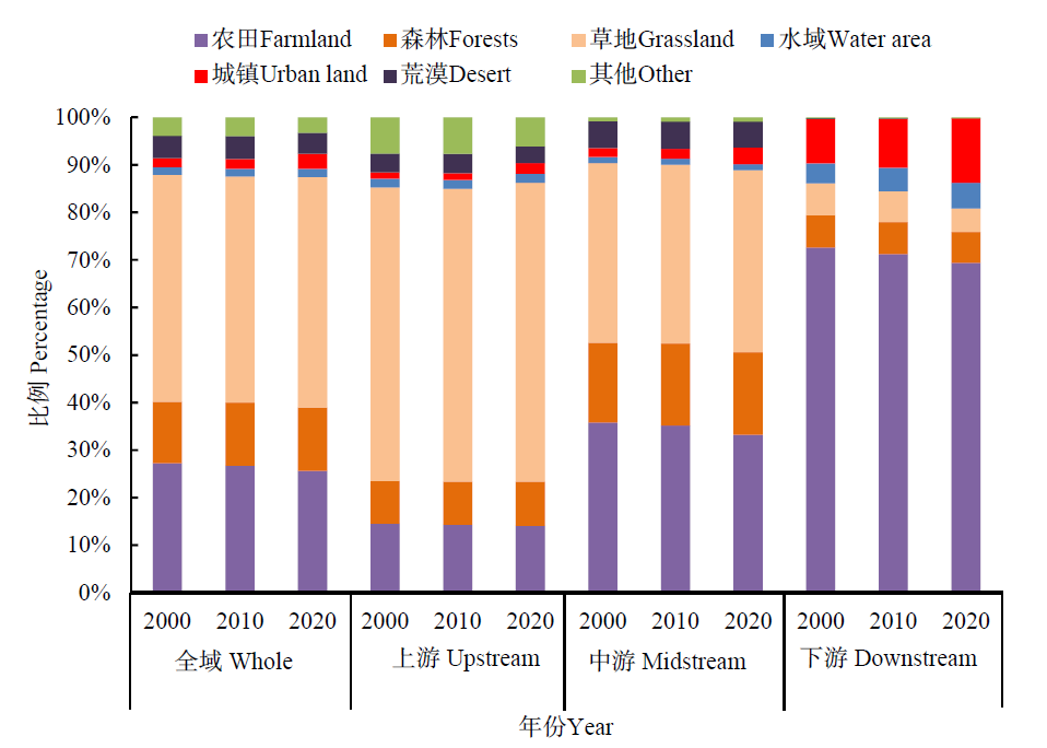
图2 黄河流域各流域段2000—2020年土地利用类型占比
Figure 2 Proportion of land use types in each basin of the Yellow River Basin from 2000 to 2020
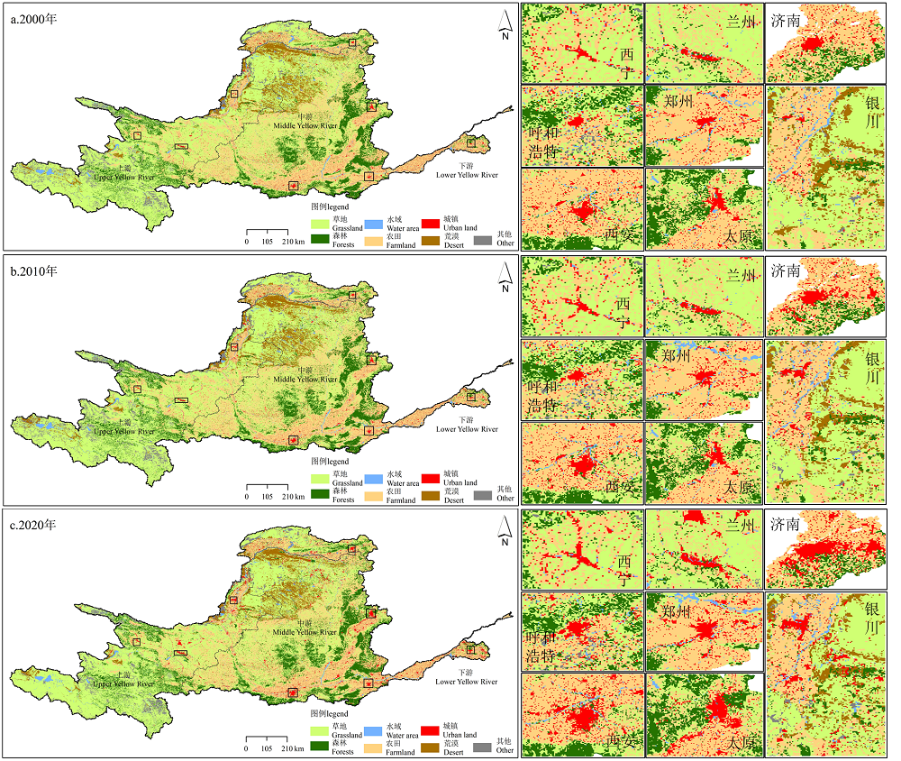
图3 2000、2010和2020年黄河流域土地利用分类图
Figure 3 Land use types classification maps of Yellow River Basin in 2000, 2010 and 2020
| 类型 Types | 面积 Area/km2 | 比例Proportion/% | 全流域变化 Changes in the Yellow River Basin | 上游变化率 Upstream rate of change/% | 中游变化率Midstream rate of change/% | 下游变化率Downstream rate of change/% | ||||
|---|---|---|---|---|---|---|---|---|---|---|
| 2000年 | 2020年 | 2000年 | 2020年 | 变化量 Amount of change/km2 | 变化率 Rate of change/% | |||||
| 农田 Farmland | 215978 | 202968 | 27.22 | 25.57 | -13010 | -6.0 | -3.8 | -6.9 | -4.4 | |
| 森林 Forests | 102624 | 106215 | 12.93 | 13.38 | 3591 | 3.5 | 3.8 | 3.7 | -3.2 | |
| 草地 Grassland | 379149 | 384688 | 47.78 | 48.46 | 5539 | 1.5 | 2.0 | 0.9 | -23.5 | |
| 水域 Water area | 12681 | 13550 | 1.60 | 1.71 | 869 | 6.9 | 10.3 | 0.2 | 22.0 | |
| 城镇 Urban land | 14801 | 25574 | 1.87 | 3.22 | 10773 | 72.8 | 51.9 | 78.2 | 35.6 | |
| 荒漠 Desert | 37405 | 34848 | 4.71 | 4.39 | -2557 | -6.8 | -3.2 | -7.9 | -80.3 | |
| 其他 Other | 30945 | 25896 | 3.90 | 3.26 | -5049 | -16.3 | -12.5 | 22.6 | 81.7 | |
表2 2000—2020年黄河流域土地利用类型变化率
Table 2 Rate of land use types change in the Yellow River Basin from 2000 to 2020
| 类型 Types | 面积 Area/km2 | 比例Proportion/% | 全流域变化 Changes in the Yellow River Basin | 上游变化率 Upstream rate of change/% | 中游变化率Midstream rate of change/% | 下游变化率Downstream rate of change/% | ||||
|---|---|---|---|---|---|---|---|---|---|---|
| 2000年 | 2020年 | 2000年 | 2020年 | 变化量 Amount of change/km2 | 变化率 Rate of change/% | |||||
| 农田 Farmland | 215978 | 202968 | 27.22 | 25.57 | -13010 | -6.0 | -3.8 | -6.9 | -4.4 | |
| 森林 Forests | 102624 | 106215 | 12.93 | 13.38 | 3591 | 3.5 | 3.8 | 3.7 | -3.2 | |
| 草地 Grassland | 379149 | 384688 | 47.78 | 48.46 | 5539 | 1.5 | 2.0 | 0.9 | -23.5 | |
| 水域 Water area | 12681 | 13550 | 1.60 | 1.71 | 869 | 6.9 | 10.3 | 0.2 | 22.0 | |
| 城镇 Urban land | 14801 | 25574 | 1.87 | 3.22 | 10773 | 72.8 | 51.9 | 78.2 | 35.6 | |
| 荒漠 Desert | 37405 | 34848 | 4.71 | 4.39 | -2557 | -6.8 | -3.2 | -7.9 | -80.3 | |
| 其他 Other | 30945 | 25896 | 3.90 | 3.26 | -5049 | -16.3 | -12.5 | 22.6 | 81.7 | |
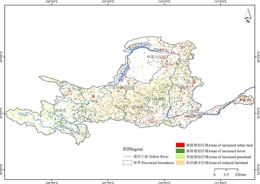
图4 2000—2020年黄河流域主要土地利用类型变化空间分布
Figure 4 Spatial distribution of major land-use change types in the Yellow River Basin from 2000 to 2020
| 类型 Types | 2000—2010年 | 2010—2020年 | 2000—2020年 | |||||
|---|---|---|---|---|---|---|---|---|
| 变化量 Amount of change/km2 | 动态度 Dynamic attitude/% | 变化量 Amount of change/km2 | 动态度 Dynamic attitude/% | 变化量 Amount of change/km2 | 动态度 Dynamic attitude/% | |||
| 农田 Farmland | -13851 | 0.18 | -19159 | 0.45 | -1.3×10⁴ | 0.32 | ||
| 森林 Forests | 2477 | 0.24 | 1114 | 0.11 | 3591 | 0.17 | ||
| 草地 Grassland | -11721 | 0.05 | 7260 | 0.19 | 5539 | 0.07 | ||
| 水域 Water area | 327 | 0.26 | 541 | 0.42 | 868 | 0.34 | ||
| 城镇 Urban land | 1490 | 1.00 | 9283 | 5.70 | 1.08×10⁴ | 3.64 | ||
| 荒漠 Desert | 891 | 0.24 | -13445 | 0.99 | -12557 | 0.37 | ||
| 其他 Other | 384 | 0.12 | -5432 | 2.10 | -5048 | 0.97 | ||
| 综合 General | 1.80×10⁴ | 0.11 | 2.69×10⁵ | 1.69 | 2.73×10⁵ | 1.72 | ||
表3 2000—2020年黄河流域土地利用类型变化幅度与动态度
Table 3 Change range and dynamic degree of land use types in the Yellow River Basin from 2000 to 2020
| 类型 Types | 2000—2010年 | 2010—2020年 | 2000—2020年 | |||||
|---|---|---|---|---|---|---|---|---|
| 变化量 Amount of change/km2 | 动态度 Dynamic attitude/% | 变化量 Amount of change/km2 | 动态度 Dynamic attitude/% | 变化量 Amount of change/km2 | 动态度 Dynamic attitude/% | |||
| 农田 Farmland | -13851 | 0.18 | -19159 | 0.45 | -1.3×10⁴ | 0.32 | ||
| 森林 Forests | 2477 | 0.24 | 1114 | 0.11 | 3591 | 0.17 | ||
| 草地 Grassland | -11721 | 0.05 | 7260 | 0.19 | 5539 | 0.07 | ||
| 水域 Water area | 327 | 0.26 | 541 | 0.42 | 868 | 0.34 | ||
| 城镇 Urban land | 1490 | 1.00 | 9283 | 5.70 | 1.08×10⁴ | 3.64 | ||
| 荒漠 Desert | 891 | 0.24 | -13445 | 0.99 | -12557 | 0.37 | ||
| 其他 Other | 384 | 0.12 | -5432 | 2.10 | -5048 | 0.97 | ||
| 综合 General | 1.80×10⁴ | 0.11 | 2.69×10⁵ | 1.69 | 2.73×10⁵ | 1.72 | ||
| 年度 Year | 类型 Types | 草地 Grassland | 城镇 Urban land | 荒漠 Desert | 农田 Farmland | 其他 Other | 森林 Forests | 水域 Water area |
|---|---|---|---|---|---|---|---|---|
| 2000—2010 | 草地 Grassland | 98.15 | 0.08 | 0.56 | 0.55 | 0.15 | 0.44 | 0.08 |
| 城镇 Urban land | 0.32 | 98.43 | 0.02 | 1.01 | 0.03 | 0.07 | 0.12 | |
| 荒漠 Desert | 2.61 | 0.14 | 96.27 | 0.49 | 0.08 | 0.30 | 0.11 | |
| 农田 Farmland | 1.49 | 0.58 | 0.02 | 96.83 | 0.14 | 0.65 | 0.30 | |
| 其他 Other | 1.43 | 0.05 | 0.14 | 0.29 | 97.59 | 0.03 | 0.47 | |
| 森林 Forests | 0.42 | 0.08 | 0.04 | 0.15 | 0.02 | 99.26 | 0.04 | |
| 水域 Water area | 1.56 | 0.22 | 0.39 | 2.80 | 1.65 | 0.29 | 93.09 | |
| 2010—2020 | 草地 Grassland | 73.12 | 1.28 | 1.98 | 13.31 | 2.50 | 7.02 | 0.79 |
| 城镇 Urban land | 12.72 | 35.16 | 0.63 | 46.15 | 0.75 | 2.73 | 1.86 | |
| 荒漠 Desert | 25.19 | 1.65 | 66.05 | 3.07 | 1.35 | 1.64 | 1.04 | |
| 农田 Farmland | 25.31 | 5.98 | 0.37 | 61.55 | 0.42 | 5.09 | 1.28 | |
| 其他 Other | 46.25 | 0.85 | 1.73 | 2.99 | 44.64 | 1.99 | 1.55 | |
| 森林 Forests | 24.75 | 0.90 | 0.40 | 9.50 | 0.41 | 63.56 | 0.48 | |
| 水域 Water area | 21.07 | 3.79 | 1.77 | 19.29 | 3.64 | 3.13 | 47.31 | |
| 2000—2020 | 草地 Grassland | 72.55 | 1.32 | 2.28 | 13.42 | 2.54 | 7.10 | 0.80 |
| 城镇 Urban land | 13.03 | 33.38 | 0.60 | 47.64 | 0.74 | 2.78 | 1.84 | |
| 荒漠 Desert | 25.88 | 1.84 | 64.58 | 3.53 | 1.32 | 1.71 | 1.14 | |
| 农田 Farmland | 25.79 | 6.14 | 0.36 | 60.57 | 0.45 | 5.32 | 1.37 | |
| 其他 Other | 46.57 | 0.82 | 1.74 | 2.87 | 44.29 | 1.98 | 1.73 | |
| 森林 Forests | 24.49 | 0.92 | 0.37 | 9.27 | 0.41 | 64.05 | 0.49 | |
| 水域 Water area | 21.40 | 3.80 | 2.01 | 19.38 | 4.44 | 3.24 | 45.73 |
表4 2000—2020年黄河流域土地利用类型的转移矩阵
Table 4 Transfer matrix of land use types in the Yellow River Basin from 2000 to 2020 %
| 年度 Year | 类型 Types | 草地 Grassland | 城镇 Urban land | 荒漠 Desert | 农田 Farmland | 其他 Other | 森林 Forests | 水域 Water area |
|---|---|---|---|---|---|---|---|---|
| 2000—2010 | 草地 Grassland | 98.15 | 0.08 | 0.56 | 0.55 | 0.15 | 0.44 | 0.08 |
| 城镇 Urban land | 0.32 | 98.43 | 0.02 | 1.01 | 0.03 | 0.07 | 0.12 | |
| 荒漠 Desert | 2.61 | 0.14 | 96.27 | 0.49 | 0.08 | 0.30 | 0.11 | |
| 农田 Farmland | 1.49 | 0.58 | 0.02 | 96.83 | 0.14 | 0.65 | 0.30 | |
| 其他 Other | 1.43 | 0.05 | 0.14 | 0.29 | 97.59 | 0.03 | 0.47 | |
| 森林 Forests | 0.42 | 0.08 | 0.04 | 0.15 | 0.02 | 99.26 | 0.04 | |
| 水域 Water area | 1.56 | 0.22 | 0.39 | 2.80 | 1.65 | 0.29 | 93.09 | |
| 2010—2020 | 草地 Grassland | 73.12 | 1.28 | 1.98 | 13.31 | 2.50 | 7.02 | 0.79 |
| 城镇 Urban land | 12.72 | 35.16 | 0.63 | 46.15 | 0.75 | 2.73 | 1.86 | |
| 荒漠 Desert | 25.19 | 1.65 | 66.05 | 3.07 | 1.35 | 1.64 | 1.04 | |
| 农田 Farmland | 25.31 | 5.98 | 0.37 | 61.55 | 0.42 | 5.09 | 1.28 | |
| 其他 Other | 46.25 | 0.85 | 1.73 | 2.99 | 44.64 | 1.99 | 1.55 | |
| 森林 Forests | 24.75 | 0.90 | 0.40 | 9.50 | 0.41 | 63.56 | 0.48 | |
| 水域 Water area | 21.07 | 3.79 | 1.77 | 19.29 | 3.64 | 3.13 | 47.31 | |
| 2000—2020 | 草地 Grassland | 72.55 | 1.32 | 2.28 | 13.42 | 2.54 | 7.10 | 0.80 |
| 城镇 Urban land | 13.03 | 33.38 | 0.60 | 47.64 | 0.74 | 2.78 | 1.84 | |
| 荒漠 Desert | 25.88 | 1.84 | 64.58 | 3.53 | 1.32 | 1.71 | 1.14 | |
| 农田 Farmland | 25.79 | 6.14 | 0.36 | 60.57 | 0.45 | 5.32 | 1.37 | |
| 其他 Other | 46.57 | 0.82 | 1.74 | 2.87 | 44.29 | 1.98 | 1.73 | |
| 森林 Forests | 24.49 | 0.92 | 0.37 | 9.27 | 0.41 | 64.05 | 0.49 | |
| 水域 Water area | 21.40 | 3.80 | 2.01 | 19.38 | 4.44 | 3.24 | 45.73 |
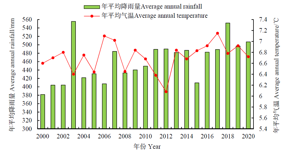
图5 2000—2020年黄河流域气温和降水变化趋势
Figure 5 Trends in temperature and precipitation in the Yellow River Basin from 2000 to 2020
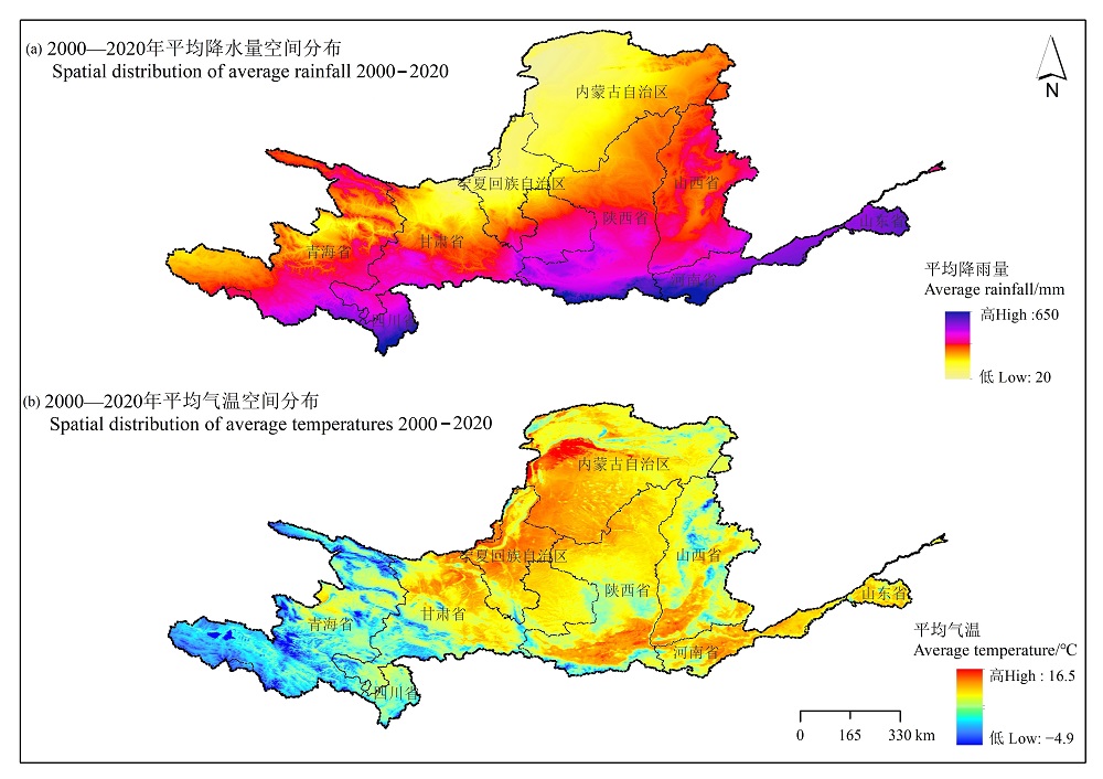
图6 2000—2020年黄河流域平均降雨量和平均气温的空间分布
Figure 6 Spatial distribution of average rainfall and average temperature of the Yellow River Basin from 2000 to 2020
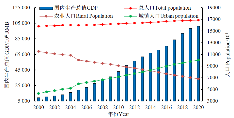
图7 2000—2020年黄河流域GDP和人口变化趋势
Figure 7 Trends in GDP and population in the Yellow River Basin from 2000 to 2020
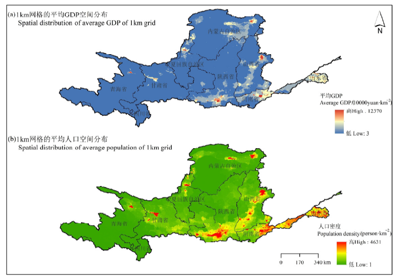
图8 2000—2020年黄河流域1 km网格GDP和人口密度的空间分布
Figure 8 Spatial distribution of GDP and population density in the 1 km grid of the Yellow River Basin from 2000 to 2020
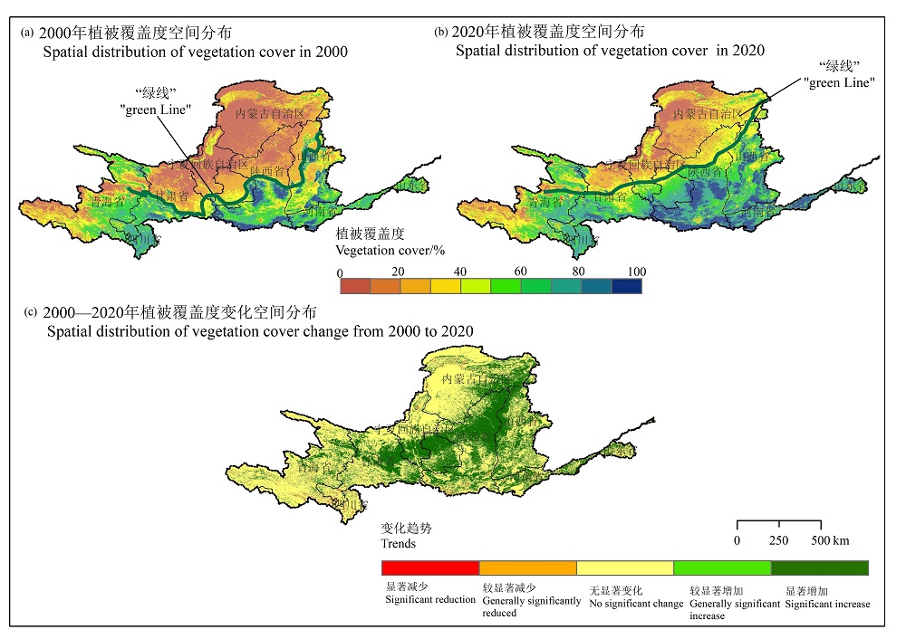
图9 2000—2020年黄河流域植被覆盖度变化空间分布 植被“绿线”为植被覆盖度20%的阈值线
Figure 9 Spatial distribution of vegetation cover change in the Yellow River Basin from 2000 to 2020 The vegetation ‘green line’ is a threshold line of 20% vegetation cover
| [1] |
DENG L, LIU G B, SHANGGUAN Z P, 2014. Land-use conversion and changing soil carbon stocksin China’s ‘Grain-for-Green’ Program: Asynthesis[J]. Global Change Biology, 20(11): 3544-3556.
DOI URL |
| [2] |
JIANG H L, XU X, GUAN M X, et al., 2020. Determining the contributions of climate change and human activities to vegetation dynamics in agro-pastural transitional zone of northern China from 2000 to 2015[J]. Science of the Total Environment, 718: 134871.
DOI URL |
| [3] |
MEYFROID P, DE BREMOND A, RYAN C M, et al., 2022. Ten facts about land systems for sustainability[J]. PNAS, 119(7): e2109217118.
DOI URL |
| [4] |
MOONEY H A, DURAIAPPAH A, LARIGAUDERIE A, 2013. Evolution of natural and social science interactions in global change research programs[J]. Proceedings of the National Academy of Sciences, 110(1): 3665-3672.
DOI URL |
| [5] |
WANG J, CHEN Y Q, SHAO X M, et al., 2012. Land-use changes and policy dimension driving forces in China: Present, trend and future[J]. Land Use Policy, 29(4): 737-749.
DOI URL |
| [6] |
ZHU Z, WOODCOCK C E, 2014. Continuous change detection and classification of land cover using all available Landsat data[J]. Remote Sensing of Environment, 144: 152-171.
DOI URL |
| [7] | 蔡宜晴, 李其江, 刘希胜, 等, 2017. 三江源区径流演变规律分析[J]. 长江科学院院报, 34(10): 1-5. |
| CAI Y Q, LI Q J, LIU X S, et al., 2017. Variation characteristics of runoff time series in the source region of Three Rivers[J]. Journal of Yangtze River Scientific Research Institute, 34(10): 1-5. | |
| [8] | 程鹏, 吴楠, 宋婷, 2022. 安徽省生态系统格局时空变化特征及驱动力分析[J]. 环境生态学, 4(Z1): 1-9. |
| CHENG P, WU N, SONG Q, 2022. Spatial temporal variation characteristics and driving forces of ecosystem pattern in Anhui Province[J]. Environmental Ecology, 4(Z1): 1-9. | |
| [9] | 迟妍妍, 王夏晖, 宝明涛, 等, 2022. 重大工程引领的黄河流域生态环境一体化治理战略研究[J]. 中国工程科学, 24(1): 104-112. |
| CHI Y Y, WANG X H, BAO M T, et al., 2022. Integrated governance of ecological environment in Yellow River Basin led by major projects[J]. Strategic Study of CAE, 24(1): 104-112. | |
| [10] | 高吉喜, 王永财, 侯鹏, 等, 2020. 近20年黄河流域陆表水域面积时空变化特征研究[J]. 水利学报, 51(9): 1157-1164. |
| GAO J X, WANG Y C, HOU P, et al., 2020. Temporal and spatial variation characteristics of land surface water area in the Yellow River basin in recent 20 years[J]. Journal of Hydraulic Engineering, 51(9): 1157-1164. | |
| [11] | 高思琦, 董国涛, 蒋晓辉, 等, 2022. 黄河源植被覆盖度变化及空间分布自然驱动力分析[J]. 生态环境学报, 31(3): 429-439. |
| GAO S Q, DONG G T, JIANG X H, et al., 2022. Analysis of vegetation coverage changes and natural driving forces of spatial distribution in the source region of the Yellow River[J]. Ecology and Environmental Sciences, 31(3): 429-439. | |
| [12] | 韩艳莉, 陈克龙, 于德永, 2019. 土地利用变化对青海湖流域生境质量的影响[J]. 生态环境学报, 28(10): 2035-2044. |
| HAN Y L, CHENG K L, YU D Y, 2019. Evaluation on the impact of land use change on habitat quality in Qinghai Lake Basin[J]. Ecology and Environmental Sciences, 28(10): 2035-2044. | |
| [13] | 何媛婷, 王石英, 袁再健, 等, 2020. 珠江三角洲土地利用变化及其对城市化发展的响应[J]. 生态环境学报, 29(2): 303-310. |
| HE Y Q, WANG S Y, YUAN Z J, et al., 2020. Land use change and its response to urbanization in the Pearl River Delta[J]. Ecology and Environmental Sciences, 29(2): 303-310. | |
| [14] |
黄葵, 卢毅敏, 魏征, 等, 2019. 土地利用和气候变化对海河流域蒸散发时空变化的影响[J]. 地球信息科学学报, 21(12): 1888-1902.
DOI |
| HUANG K, LU Y M, WEI Z, et al., 2019. Effects of land use and climate change on spatiotemporal changes of evapotranspiration in Haihe River Basin[J]. Journal of Geo-information Science, 21(12): 1888-1902. | |
| [15] | 江文甲, 林满红, 翁佩莹, 等, 2022. 福建省安溪县土地利用时空演变规律及其关键驱动因素[J]. 生态学报, 42(2): 513-527. |
| JIANG W J, LIN M H, WEN P Y, et al., 2022. Spatio-temporal evolution of land use and its key driving factors in Anxi County of Fujian Province[J]. Acta Ecologica Sinica, 42(2): 513-527. | |
| [16] | 李嘉琪, 段梦琦, 尹建国, 等, 2022. 近10年青岛市土地利用景观格局时空变化特征[J]. 地理空间信息, 20(5): 22-26. |
| LI J Q, DUAN M Q, YIN J G, et al., 2022. Spatio-temporal change characteristics of land use landscape pattern in Qingdao in recent 10 years[J]. Geospatial Information, 20(5): 22-26. | |
| [17] | 李明薇, 郧雨旱, 陈伟强, 等, 2018. 河南省“三生空间”分类与时空格局分析[J]. 中国农业资源与区划, 39(9): 13-20. |
| LI M W, YUN Y H, CHEN W Q, et al., 2018. Analysis of the classification and spatio-temporal pattern of the “three living spaces” in Henan Province[J]. Chinese Journal of Agricultural Resources and Regional Planning, 39(9): 13-20. | |
| [18] | 刘海, 刘凤, 郑粮, 2021. 气候变化及人类活动对黄河流域植被覆盖变化的影响[J]. 水土保持学报, 35(4): 143-151. |
| LIU H, LIU F, ZHENG L, 2021. Effects of climate change and human activities on vegetation cover change in the Yellow River Basin[J]. Journal of Soil and Water Conservation, 35(4): 143-151. | |
| [19] | 刘纪远, 匡文慧, 张增祥, 等, 2014. 20世纪80年代末以来中国土地利用变化的基本特征与空间格局[J]. 地理学报, 69(1): 3-14. |
|
LIU J Y, KUANG W H, ZHANG Z X, et al., 2014. Spatiotemporal characteristics, patterns and causes of land use changes in China since the late 1980s[J]. Acta Geographica Sinica, 69(1): 3-14.
DOI |
|
| [20] |
刘纪远, 宁佳, 匡文慧, 等, 2018. 2010—2015年中国土地利用变化的时空格局与新特征[J]. 地理学报, 73(5): 789-802.
DOI |
|
LIU J Y, NING J, KUANG W H, et al., 2018. Spatio-temporal patterns and characteristics of land-use change in China during 2010-2015[J]. Acta Geographica Sinica, 73(5): 789-802.
DOI |
|
| [21] |
陆大道, 孙东琪, 2019. 黄河流域的综合治理与可持续发展[J]. 地理学报, 74(12): 2431-2436.
DOI |
|
LU D D, SUN D Q, 2019. Development and management tasks of the Yellow River Basin: A preliminary understanding and suggestion[J]. Acta Geographica Sinica, 74(12): 2431-2436.
DOI |
|
| [22] | 牟雪洁, 张箫, 王夏晖, 等, 2022. 黄河流域生态系统变化评估与保护修复策略研究[J]. 中国工程科学, 24(1): 113-121. |
| MOU X J, ZHANG X, WANG X H, et al., 2022. Ecological change assessment and protection strategy in the Yellow River Basin[J]. Strategic Study of CAE, 24(1): 113-121. | |
| [23] | 孙璐, 刘艳芳, 2017. 基于RS和GIS的武汉市土地利用变化研究[J]. 国土与自然资源研究, 41(1): 41-44. |
| SUN L, LIU Y F, 2017. Study on the change of land use in the Wuhan city based on RS and GIS[J]. Territory & Natural Resources Study, 41(1): 41-44. | |
| [24] |
孙梦华, 牛文浩, 张蚌蚌, 等, 2021. 黄河流域土地利用变化下生态系统服务价值时空演变及其响应——以陕甘宁地区为例[J]. 应用生态学报, 32(11): 3913-3922.
DOI |
| SUN M H, NIU W H, ZHANG B B, et al., 2021. Spatial-temporal evolution and responses of ecosystem service value under land use change in the Yellow River Basin: A case study of Shaanxi-Gansu-Ningxia region, Northwest China[J]. Chinese Journal of Applied Ecology, 32(11): 3913-3922. | |
| [25] | 孙宗耀, 孙希华, 徐新良, 等, 2018. 土地利用差异与变化对区域热环境贡献研究——以京津冀城市群为例[J]. 生态环境学报, 27(7):1313-1322. |
| SUN Z Y, SUN X H, XU X L, et al., 2018. Study on the contribution of land use heterogeneity and change to regional thermal environment: A case study of Beijing-Tianjin-Hebei urban agglomeration[J]. Ecology and Environmental Sciences, 27(7): 1313-1322. | |
| [26] | 肖东洋, 牛海鹏, 闫弘轩, 等, 2020. 1990—2018年黄河流域(河南段)土地利用格局时空演变[J]. 农业工程学报, 36(15): 271-281, 326. |
| XIAO D Y, NIU H P, YAN H X, et al., 2020. Spatiotemperal evolution of land use pattern in the Yellow River Basin (Henan section) from 1990 to 2018[J]. Transactions of the Chinese Society of Agricultural Engineering (Transactions of the CSAE), 36(15): 271-281, 326. | |
| [27] |
徐辉, 师诺, 武玲玲, 等, 2020. 黄河流域高质量发展水平测度及其时空演变[J]. 资源科学, 42(1): 115-126.
DOI |
|
XU H, SHI N, WU L L, et al., 2020. High-quality development level and its spatiotemporal changes in the Yellow River Basin[J]. Resources Science, 42(1): 115-126.
DOI |
|
| [28] | 徐羽, 钟业喜, 冯兴华, 等, 2017. 江西省土地利用变化及其对人类活动的响应[J]. 水土保持研究, 24(1): 181-186, 193. |
| XU Y, ZHONG Y X, FENG X H, et al., 2017. Response of land use change to the human activities in Jiangxi Province[J]. Research of Soil and Water Conservation, 24(1): 181-186, 193. | |
| [29] | 许茜, 李奇, 陈懂懂, 等, 2017. 三江源土地利用变化特征及因素分析[J]. 生态环境学报, 26(11): 1836-1843. |
| XU Q, LI Q, CHEN D D, et al., 2017. The spatial-temporal characteristic of land use change in Sanjiangyuan Region and its effect factors[J]. Ecology and Environmental Sciences, 26(11): 1836-1843. | |
| [30] | 徐晓然, 谢跟踪, 邱彭华, 2018. 1964—2015年海南省八门湾红树林湿地及其周边土地景观动态分析[J]. 生态学报, 38(20): 7458-7468. |
| XU X R, XIE G Z, QIU P H, 2018. Dynamic analysis of landscape changes in Bamen port and the surrounding lands of Hainan Province from 1964 to 2015[J]. Acta Ecologica Sinica, 38(20): 7458-7468. | |
| [31] | 许学工, 彭慧芳, 徐勤政, 等, 2006. 海岸带快速城市化的土地资源冲突与协调——以山东半岛为例[J]. 北京大学学报 (自然科学版), 42(4): 527-533. |
| XU X G, PENG H F, XU Q Z, et al., 2006. Land resource conflicts and coordination in fast urbanized coastal zone: A case study of the Shandong Peninsula[J]. Acta Scientiarum Naturalium Universitatis Pekinensis, 42(4): 527-533. | |
| [32] | 杨国清, 朱文锐, 文雅, 等, 2019. 20年来广东省土地利用碳排放强度与效率空间分异研究[J]. 生态环境学报, 28(2): 332-340. |
| YANG G Q, ZHU W R, WEN Y, et al., 2019. Spatial differentiation in the intensity and efficiency of carbonemission from land use in Guangdong province in past two decades[J]. Ecology and Environmental Sciences, 28(2): 332-340. | |
| [33] | 叶培龙, 张强, 王莺, 等, 2020. 1980—2018年黄河上游气候变化及其对生态植被和径流量的影响[J]. 大气科学学报, 43(6): 967-979. |
| YE P L, ZHANG Q, WANG Y, et al., 2020. Climate change in the upper Yellow River Basin and its impact on ecological vegetation and runoff from 1980 to 2018[J]. Transactions of Atmospheric Sciences, 43(6): 967-979. | |
| [34] | 苑韶峰, 唐奕钰, 申屠楚宁, 2019. 土地利用转型时空演变及其生态环境效应——基于长江经济带127个地级市的实证研究[J]. 经济地理, 39(9): 174-181. |
| YUAN S F, TANG Y Y, SHENGTU C N, 2019. Spatiotemporal change of land-use transformation and its Eco-environmental response: A case of 127 counties in Yangtze River Economic Belt[J]. Economic Geography, 39(9): 174-181. | |
| [35] |
张佰发, 苗长虹, 2020. 黄河流域土地利用时空格局演变及驱动力[J]. 资源科学, 42(3): 460-473.
DOI |
|
ZHANG B F, MIAO C H, 2020. Spatiotemporal changes and driving forces of land use in the Yellow River Basin[J]. Resources Science, 42(3): 460-473.
DOI |
|
| [36] | 张静, 杜加强, 盛芝露, 等, 2021. 1982—2015年黄河流域植被NDVI时空变化及影响因素分析[J]. 生态环境学报, 30(5): 929-937. |
| ZHANG J, DU J Q, SHENG Z L, et al., 2021. Spatio-temporal changes of vegetation cover and their influencing factors in the Yellow River Basin from 1982 to 2015[J]. Ecology and Environmental Sciences, 30(5): 929-937. | |
| [37] | 赵倩倩, 李建华, 张桂琴, 等, 2022. 气候变化背景下黄河流域植被变化及其成因[J]. 气候与环境研究, 27(1): 157-169. |
| ZHAO Q Q, LI J H, ZHANG G Q, et al., 2022. Vegetation changes and their causes in the Yellow River Basin under the background of climate change[J]. Climatic and Environmental Research, 27(1): 157-169. | |
| [38] | 中华人民共和国自然资源部, 2017. 土地利用现状分类: GB/T 21010—2017[S]. 北京: 中国国家标准化管理委员会: 6-10. |
| Ministry of Natural Resources, 2017. Current land use classification: GB/T 21010—2017[S]. Beijing: Standardization Administration of China: 6-10. |
| [1] | 王琳, 卫伟. 黄土高原典型县域生态系统服务变化特征及驱动因素[J]. 生态环境学报, 2023, 32(6): 1140-1148. |
| [2] | 刘霞, 郭澍, 王琳. 区域一体化地区的土地利用与生态服务价值研究——以双莱先行区为例[J]. 生态环境学报, 2023, 32(6): 1163-1172. |
| [3] | 翁升恒, 张玉琴, 姜冬昕, 潘卫华, 李丽纯, 张方敏. 福建省森林植被NEP时空变化及影响因子分析[J]. 生态环境学报, 2023, 32(5): 845-856. |
| [4] | 王超, 杨倩楠, 张池, 刘同旭, 张晓龙, 陈静, 刘科学. 丹霞山不同土地利用方式土壤磷组分特征及其有效性[J]. 生态环境学报, 2023, 32(5): 889-897. |
| [5] | 李建辉, 党争, 陈琳. 黄河几字弯都市圈PM2.5时空特征及影响因素分析[J]. 生态环境学报, 2023, 32(4): 697-705. |
| [6] | 王铁铮, 瞿心悦, 刘春香, 李有志. 东江湖水质时空变化规律及其与流域土地利用的关系[J]. 生态环境学报, 2023, 32(4): 722-732. |
| [7] | 于菲, 曾海龙, 房怀阳, 付玲芳, 林澍, 董家豪. 典型感潮河网浮游藻类功能群时空变化特征及水质评价[J]. 生态环境学报, 2023, 32(4): 756-765. |
| [8] | 张林, 齐实, 周飘, 伍冰晨, 张岱, 张岩. 北京山区针阔混交林地土壤有机碳含量的影响因素研究[J]. 生态环境学报, 2023, 32(3): 450-458. |
| [9] | 何艳虎, 龚镇杰, 吴海彬, 蔡宴朋, 杨志峰, 陈晓宏. 粤港澳大湾区城市生态效率时空演变及影响因素[J]. 生态环境学报, 2023, 32(3): 469-480. |
| [10] | 李语诗, 夏志业, 张蕾. 基于SSPs多情景目标的2030年成渝经济圈土地利用碳排放预测及其空间优化[J]. 生态环境学报, 2023, 32(3): 535-544. |
| [11] | 郝金虎, 韦玮, 李胜男, 马牧源, 李肖夏, 杨洪国, 姜琦宇, 柴沛东. 基于GEE平台的京津冀长时序水体时空格局及其影响因素[J]. 生态环境学报, 2023, 32(3): 556-566. |
| [12] | 盛美君, 李胜君, 杨昕玥, 王蕊, 李洁, 李刚, 修伟明. 华北潮土农田土壤酶活性对土地利用强度的响应特征探讨[J]. 生态环境学报, 2023, 32(2): 299-308. |
| [13] | 张莉, 李铖, 谭皓泽, 韦家怡, 程炯, 彭桂香. 广州典型城市林地对大气颗粒物的削减效应及影响因素[J]. 生态环境学报, 2023, 32(2): 341-350. |
| [14] | 王全超, 吉恒宽, 李思敏, 李财生, 侯正伟, 邓万刚, 吴治澎, 王登峰. 海南东寨港流域土壤-溪流连续体溶解态黑碳分子特征及其界面转化机制[J]. 生态环境学报, 2023, 32(1): 139-149. |
| [15] | 郑晓豪, 陈颖彪, 郑子豪, 郭城, 黄卓男, 周泳诗. 湖北省生态系统服务价值动态变化及其影响因素演变[J]. 生态环境学报, 2023, 32(1): 195-206. |
| 阅读次数 | ||||||||||||||||||||||||||||||||||||||||||||||||||
|
全文 626
|
|
|||||||||||||||||||||||||||||||||||||||||||||||||
|
摘要 694
|
|
|||||||||||||||||||||||||||||||||||||||||||||||||