生态环境学报 ›› 2024, Vol. 33 ›› Issue (6): 908-918.DOI: 10.16258/j.cnki.1674-5906.2024.06.008
廖洪圣1,2( ), 卫伟1,2,3,*(), 石宇1,2
收稿日期:2024-03-14
出版日期:2024-06-18
发布日期:2024-07-30
通讯作者:
* 卫伟。E-mail:weiwei@rcees.ac.cn作者简介:廖洪圣(1997年生),男,硕士研究生,研究方向为区域生态环境演变监测。E-mail: lhs769160981@163.com
基金资助:
LIAO Hongsheng1,2(), WEI Wei1,2,3,*(), SHI Yu1,2
Received:2024-03-14
Online:2024-06-18
Published:2024-07-30
摘要:
黄土丘陵区作为中国生态脆弱区,水土流失形势严峻,准确评估其土壤侵蚀时空变化规律,深入探究其背后的驱动机理,对于指导当地水土保持工作具有重要科学意义。以祖厉河流域为研究对象,基于RUSLE土壤侵蚀评估模型,结合转移矩阵、空间自相关和地理探测器等地学统计分析工具,对2000—2020年间土壤侵蚀模数的空间分布格局及背后驱动力进行评估。结果显示,1)2000—2020年祖厉河流域土壤侵蚀强度等级以微度和轻度为主,20年间平均土壤侵蚀模数由1.299×10³ t∙km−2∙a−1下降至635 t∙km−2∙a−1,即侵蚀强度等级由轻度侵蚀降为微度侵蚀。2)2000—2010年期间,约有1.968×10³ km2的区域土壤侵蚀状况向良性方向发展,占流域总面积的18.4%;而在2010—2020年间,约有3.089×10³ km2的区域土壤侵蚀情况得到改善,占流域总面积的28.9%,水土流失治理效果显著。3)祖厉河流域土壤侵蚀存在明显的空间聚集性,其中“高-高”聚集区主要分布在会宁县与安定区交界处以及流域西北部的山地丘陵地带,“低-低”聚集主要分布在流域北部和西南部沿岸平原地区,20年来该“高-高”和“低-低”聚集类型面积逐年减少。4)降水是影响土壤侵蚀的首要因素,梯田在改善土壤侵蚀状况中发挥了重要作用,自然因子与人类活动因子之间的共同作用塑造了土壤侵蚀空间分布格局。未来水土保持治理重点应聚焦于低温干旱、高海拔、地势陡峭、植被覆盖低、土壤砂粉化程度高和梯田分布少等条件的风险区。
中图分类号:
廖洪圣, 卫伟, 石宇. 黄土丘陵区典型流域土壤侵蚀时空演变特征及其驱动机制:以祖厉河为例[J]. 生态环境学报, 2024, 33(6): 908-918.
LIAO Hongsheng, WEI Wei, SHI Yu. Characteristics of Spatial and Temporal Evolution of Soil Erosion in Typical Watersheds in Loess Hilly Areas and Its Driving Mechanisms: A Case Study of Zuli River[J]. Ecology and Environment, 2024, 33(6): 908-918.

图1 研究区位置
Figure 1 Location of the study area
| 因子类型 | 因子名称 | 分辨率 | 单位 | 数据来源 |
|---|---|---|---|---|
| 气候要素 | 气温 | 1 km | ℃ | ERA5气象数据集 ( |
| 降水 | 1 km | mm | CHIRPS气候灾害组红外降水与站数据集 ( | |
| 植被要素 | 植被覆盖度 | 30 m | 国家生态科学数据中心 ( | |
| 土壤要素 | 砂粒含量 | 30 m | % | 世界土壤数据库 (HWSD) 土壤数据集 ( |
| 粉粒含量 | 30 m | % | 世界土壤数据库 (HWSD) 土壤数据集 ( | |
| 粘粒含量 | 30 m | % | 世界土壤数据库 (HWSD) 土壤数据集 ( | |
| 含碳量 | 30 m | % | 世界土壤数据库 (HWSD) 土壤数据集 ( | |
| 地貌地形要素 | 高程 | 30 m | m | 美国航空航天局 ( |
| 坡度 | 30 m | ° | ArcGIS 10.2软件计算生成 | |
| 坡向 | 30 m | ArcGIS 10.2软件计算生成 | ||
| 地貌类型 | 30 m | 中国科学院资源环境与数据中心 ( | ||
| 土地利用要素 | 土地利用类型 | 30 m | 中国科学院资源环境与数据中心 ( | |
| 距离道路距离 | 30 m | m | 中国科学院资源环境与数据中心 ( | |
| 梯田分布密度 | 30 m | 中国黄土高原梯田变化数据 ( | ||
| 社会经济要素 | 人口密度 | 100 m | person∙km−2 | 世界人口分布数据集 ( |
| 夜间灯光 | 1 km | NOAA夜间灯光数据集 ( | ||
| GDP | 1 km | yuan∙person−1 | 地球数据资源云 ( |
表1 数据类型及来源
Table 1 Data types and sources
| 因子类型 | 因子名称 | 分辨率 | 单位 | 数据来源 |
|---|---|---|---|---|
| 气候要素 | 气温 | 1 km | ℃ | ERA5气象数据集 ( |
| 降水 | 1 km | mm | CHIRPS气候灾害组红外降水与站数据集 ( | |
| 植被要素 | 植被覆盖度 | 30 m | 国家生态科学数据中心 ( | |
| 土壤要素 | 砂粒含量 | 30 m | % | 世界土壤数据库 (HWSD) 土壤数据集 ( |
| 粉粒含量 | 30 m | % | 世界土壤数据库 (HWSD) 土壤数据集 ( | |
| 粘粒含量 | 30 m | % | 世界土壤数据库 (HWSD) 土壤数据集 ( | |
| 含碳量 | 30 m | % | 世界土壤数据库 (HWSD) 土壤数据集 ( | |
| 地貌地形要素 | 高程 | 30 m | m | 美国航空航天局 ( |
| 坡度 | 30 m | ° | ArcGIS 10.2软件计算生成 | |
| 坡向 | 30 m | ArcGIS 10.2软件计算生成 | ||
| 地貌类型 | 30 m | 中国科学院资源环境与数据中心 ( | ||
| 土地利用要素 | 土地利用类型 | 30 m | 中国科学院资源环境与数据中心 ( | |
| 距离道路距离 | 30 m | m | 中国科学院资源环境与数据中心 ( | |
| 梯田分布密度 | 30 m | 中国黄土高原梯田变化数据 ( | ||
| 社会经济要素 | 人口密度 | 100 m | person∙km−2 | 世界人口分布数据集 ( |
| 夜间灯光 | 1 km | NOAA夜间灯光数据集 ( | ||
| GDP | 1 km | yuan∙person−1 | 地球数据资源云 ( |
| 因子名称 | 计算公式 | 参数说明 |
|---|---|---|
| 降水因子R | $R\mathrm{=}17.02\times \sum\limits_{i=1}^{12}{\left( 1.735\times {{10}^{\left( 1.5\times \lg \frac{p_{i}^{2}}{p}-0.8188 \right)}} \right)}$ | R——降水因子; P——年均降水量; Pi ——第i月的月均降水量 |
| 土壤可蚀因子K | $\begin{align} & K\mathrm{=}0.1317\times \left\{ 0.2+0.3\exp \left[ -0.0256{{S}_{\mathrm{a}}}\left( 1-\frac{{{S}_{\mathrm{i}}}}{100} \right) \right] \right\}\times \left( \frac{{{S}_{\mathrm{i}}}}{{{C}_{\mathrm{l}}}+{{S}_{\mathrm{i}}}} \right)\times \\ & \left[ 1-\frac{0.25{{O}_{\mathrm{c}}}}{{{O}_{\mathrm{c}}}+\exp (3.72-2.95{{O}_{\mathrm{c}}})} \right]\times \left[ 1-\frac{0.7{{S}_{\mathrm{n}}}}{{{S}_{\mathrm{n}}}+\exp (22.9{{S}_{\mathrm{n}}}-5.51)} \right] \\ \end{align}$ | K——土壤可蚀因子; Sa——砂粒含量; Si ——粉粒含量; Cl——黏土含量; Oc——土壤有机碳含量; Sn=(1−Sa/100) |
| 地形因子L和S | $\begin{array}{c} S=\left\{\begin{array}{cr} 10.8 \times \sin \theta+0.036 & \theta<5.1428^{\circ} \\ 16.8 \times \sin \theta-0.5 & 5.1428^{\circ} \leq \theta \leq 14.032^{\circ} \\ 21.97 \times \sin \theta-0.96 & \theta \geq 14.0362^{\circ} \end{array}\right. \\ L=\left[\frac{\lambda}{22.13}\right]^{m} \\ m=\frac{\eta}{\eta+1} \\ \eta=\frac{\frac{\sin \theta}{0.0896}}{\left[(3 \times \sin \theta)^{0.8}+0.56\right]} \end{array}$ | S和L——坡度因子和坡长因子; θ——坡度; λ——水平投影长度; m——坡长指数; η——细沟侵蚀度和面蚀侵蚀度的比值 |
| 植被覆盖因子C | $\begin{array}{c} C=\left\{\begin{array}{ll} C=1 &F_{\mathrm{v}}=0 \\ C=0.6508-0.3436 \times \lg F_{\mathrm{v}} & 0<F_{\mathrm{v}}<78.3 \% \\ C=0 & F_{\mathrm{v}} \geq 78.3 \% \end{array}\right. \\ \qquad F_{\mathrm{v}}=\frac{N-N_{\mathrm{s}}}{N_{\mathrm{v}}-N_{\mathrm{s}}} \end{array}$ | C——植被覆盖因子; Fv——植被覆盖度; N——归一化植被指数; Ns——裸土像元归一化植被指数; Nv——全植被覆盖像元归一化植被指数 |
表2 各因子计算公式与说明
Table 2 Formulas and descriptions of the factors
| 因子名称 | 计算公式 | 参数说明 |
|---|---|---|
| 降水因子R | $R\mathrm{=}17.02\times \sum\limits_{i=1}^{12}{\left( 1.735\times {{10}^{\left( 1.5\times \lg \frac{p_{i}^{2}}{p}-0.8188 \right)}} \right)}$ | R——降水因子; P——年均降水量; Pi ——第i月的月均降水量 |
| 土壤可蚀因子K | $\begin{align} & K\mathrm{=}0.1317\times \left\{ 0.2+0.3\exp \left[ -0.0256{{S}_{\mathrm{a}}}\left( 1-\frac{{{S}_{\mathrm{i}}}}{100} \right) \right] \right\}\times \left( \frac{{{S}_{\mathrm{i}}}}{{{C}_{\mathrm{l}}}+{{S}_{\mathrm{i}}}} \right)\times \\ & \left[ 1-\frac{0.25{{O}_{\mathrm{c}}}}{{{O}_{\mathrm{c}}}+\exp (3.72-2.95{{O}_{\mathrm{c}}})} \right]\times \left[ 1-\frac{0.7{{S}_{\mathrm{n}}}}{{{S}_{\mathrm{n}}}+\exp (22.9{{S}_{\mathrm{n}}}-5.51)} \right] \\ \end{align}$ | K——土壤可蚀因子; Sa——砂粒含量; Si ——粉粒含量; Cl——黏土含量; Oc——土壤有机碳含量; Sn=(1−Sa/100) |
| 地形因子L和S | $\begin{array}{c} S=\left\{\begin{array}{cr} 10.8 \times \sin \theta+0.036 & \theta<5.1428^{\circ} \\ 16.8 \times \sin \theta-0.5 & 5.1428^{\circ} \leq \theta \leq 14.032^{\circ} \\ 21.97 \times \sin \theta-0.96 & \theta \geq 14.0362^{\circ} \end{array}\right. \\ L=\left[\frac{\lambda}{22.13}\right]^{m} \\ m=\frac{\eta}{\eta+1} \\ \eta=\frac{\frac{\sin \theta}{0.0896}}{\left[(3 \times \sin \theta)^{0.8}+0.56\right]} \end{array}$ | S和L——坡度因子和坡长因子; θ——坡度; λ——水平投影长度; m——坡长指数; η——细沟侵蚀度和面蚀侵蚀度的比值 |
| 植被覆盖因子C | $\begin{array}{c} C=\left\{\begin{array}{ll} C=1 &F_{\mathrm{v}}=0 \\ C=0.6508-0.3436 \times \lg F_{\mathrm{v}} & 0<F_{\mathrm{v}}<78.3 \% \\ C=0 & F_{\mathrm{v}} \geq 78.3 \% \end{array}\right. \\ \qquad F_{\mathrm{v}}=\frac{N-N_{\mathrm{s}}}{N_{\mathrm{v}}-N_{\mathrm{s}}} \end{array}$ | C——植被覆盖因子; Fv——植被覆盖度; N——归一化植被指数; Ns——裸土像元归一化植被指数; Nv——全植被覆盖像元归一化植被指数 |
| 因子名称 | 普通耕地 | 梯田耕地 | 林地 | 草地 | 水体 | 建设用地 | 裸地 |
|---|---|---|---|---|---|---|---|
| p值 | 1 | 0.084 | 0.17 | 0.3 | 0 | 0 | 1 |
表3 P因子赋值表
Table 3 P-factor assignment table
| 因子名称 | 普通耕地 | 梯田耕地 | 林地 | 草地 | 水体 | 建设用地 | 裸地 |
|---|---|---|---|---|---|---|---|
| p值 | 1 | 0.084 | 0.17 | 0.3 | 0 | 0 | 1 |
| 级别 | 平均侵蚀模数/(t∙km−2∙a−1) | 平均流失厚度/(mm∙a−1) |
|---|---|---|
| 无侵蚀 | 0 | 0 |
| 微度侵蚀 | 0‒1000 | 0‒0.74 |
| 轻度侵蚀 | 1000‒2500 | 0.74‒1.9 |
| 中度侵蚀 | 2500‒5000 | 1.9‒3.7 |
| 强烈侵蚀 | 5000‒8000 | 3.7‒5.9 |
| 极强烈侵蚀 | 8000‒15000 | 5.9‒11.1 |
| 剧烈侵蚀 | >15000 | >11.1 |
表4 土壤侵蚀强度分级表
Table 4 Soil erosion intensity classification table
| 级别 | 平均侵蚀模数/(t∙km−2∙a−1) | 平均流失厚度/(mm∙a−1) |
|---|---|---|
| 无侵蚀 | 0 | 0 |
| 微度侵蚀 | 0‒1000 | 0‒0.74 |
| 轻度侵蚀 | 1000‒2500 | 0.74‒1.9 |
| 中度侵蚀 | 2500‒5000 | 1.9‒3.7 |
| 强烈侵蚀 | 5000‒8000 | 3.7‒5.9 |
| 极强烈侵蚀 | 8000‒15000 | 5.9‒11.1 |
| 剧烈侵蚀 | >15000 | >11.1 |

图2 土壤侵蚀强度空间分布变化
Figure 2 Changes in the spatial distribution of soil erosion intensity
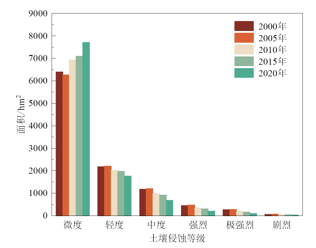
图3 土壤侵蚀强度时间分布变化
Figure 3 Changes in the temporal distribution of soil erosion intensity
| 2000年 | 2010年 | ||||||||
|---|---|---|---|---|---|---|---|---|---|
| 无侵蚀 | 微度 | 轻度 | 中度 | 强烈 | 极强烈 | 剧烈 | 转出面积 | 转出率/% | |
| 无侵蚀 | 113 | 27.7 | 1.92 | 0.79 | 0.26 | 0.17 | 0.06 | 30.9 | 21.5 |
| 微度 | 45.6 | 5715 | 387 | 144 | 58.4 | 27.8 | 10.2 | 674 | 10.5 |
| 轻度 | 4.35 | 864 | 1188 | 85.8 | 14.7 | 12.7 | 6.92 | 988 | 45.4 |
| 中度 | 1.96 | 199 | 384 | 554 | 24.1 | 7.09 | 1.21 | 617 | 52.7 |
| 强烈 | 0.87 | 69.6 | 37.9 | 167 | 159 | 11.0 | 1.31 | 287 | 64.4 |
| 极强烈 | 0.46 | 42.1 | 13.8 | 23.1 | 80.1 | 107 | 3.24 | 163 | 60.2 |
| 剧烈 | 0.10 | 2.26 | 7.37 | 2.56 | 2.77 | 20.8 | 25.1 | 35.8 | 58.8 |
表5 2000—2010年土地侵蚀强度转移矩阵
Table 5 Land erosion intensity transfer matrix 2000 to 2010
| 2000年 | 2010年 | ||||||||
|---|---|---|---|---|---|---|---|---|---|
| 无侵蚀 | 微度 | 轻度 | 中度 | 强烈 | 极强烈 | 剧烈 | 转出面积 | 转出率/% | |
| 无侵蚀 | 113 | 27.7 | 1.92 | 0.79 | 0.26 | 0.17 | 0.06 | 30.9 | 21.5 |
| 微度 | 45.6 | 5715 | 387 | 144 | 58.4 | 27.8 | 10.2 | 674 | 10.5 |
| 轻度 | 4.35 | 864 | 1188 | 85.8 | 14.7 | 12.7 | 6.92 | 988 | 45.4 |
| 中度 | 1.96 | 199 | 384 | 554 | 24.1 | 7.09 | 1.21 | 617 | 52.7 |
| 强烈 | 0.87 | 69.6 | 37.9 | 167 | 159 | 11.0 | 1.31 | 287 | 64.4 |
| 极强烈 | 0.46 | 42.1 | 13.8 | 23.1 | 80.1 | 107 | 3.24 | 163 | 60.2 |
| 剧烈 | 0.10 | 2.26 | 7.37 | 2.56 | 2.77 | 20.8 | 25.1 | 35.8 | 58.8 |
| 2000年 | 2010年 | ||||||||
|---|---|---|---|---|---|---|---|---|---|
| 无侵蚀 | 微度 | 轻度 | 中度 | 强烈 | 极强烈 | 剧烈 | 转出面积 | 转出率/% | |
| 无侵蚀 | 112 | 28.7 | 1.78 | 0.64 | 0.18 | 0.11 | 0.03 | 31.5 | 21.9 |
| 微度 | 61.0 | 5880 | 276 | 101 | 32.5 | 20.6 | 16.7 | 508 | 7.95 |
| 轻度 | 5.52 | 1395 | 700 | 46.3 | 10.8 | 9.16 | 8.82 | 1476 | 67.8 |
| 中度 | 2.48 | 260 | 671 | 220 | 11.2 | 3.41 | 3.21 | 951 | 81.2 |
| 强烈 | 1.09 | 79.6 | 81.1 | 241 | 39.2 | 3.46 | 1.19 | 407 | 91.2 |
| 极强烈 | 0.59 | 42.9 | 23.6 | 71.7 | 99.6 | 30.5 | 1.18 | 240 | 88.7 |
| 剧烈 | 0.12 | 5.82 | 3.82 | 5.13 | 9.44 | 29.1 | 7.45 | 53.4 | 87.8 |
表6 2010—2020年土地侵蚀强度转移矩阵
Table 6 Land erosion intensity transfer matrix 2010 to 2020
| 2000年 | 2010年 | ||||||||
|---|---|---|---|---|---|---|---|---|---|
| 无侵蚀 | 微度 | 轻度 | 中度 | 强烈 | 极强烈 | 剧烈 | 转出面积 | 转出率/% | |
| 无侵蚀 | 112 | 28.7 | 1.78 | 0.64 | 0.18 | 0.11 | 0.03 | 31.5 | 21.9 |
| 微度 | 61.0 | 5880 | 276 | 101 | 32.5 | 20.6 | 16.7 | 508 | 7.95 |
| 轻度 | 5.52 | 1395 | 700 | 46.3 | 10.8 | 9.16 | 8.82 | 1476 | 67.8 |
| 中度 | 2.48 | 260 | 671 | 220 | 11.2 | 3.41 | 3.21 | 951 | 81.2 |
| 强烈 | 1.09 | 79.6 | 81.1 | 241 | 39.2 | 3.46 | 1.19 | 407 | 91.2 |
| 极强烈 | 0.59 | 42.9 | 23.6 | 71.7 | 99.6 | 30.5 | 1.18 | 240 | 88.7 |
| 剧烈 | 0.12 | 5.82 | 3.82 | 5.13 | 9.44 | 29.1 | 7.45 | 53.4 | 87.8 |

图4 土壤侵蚀强度转移弦图
Figure 4 Soil erosion intensity transfer chord diagram

图5 土壤侵蚀模数空间聚集分布
Figure 5 Spatially aggregated distribution of soil erosion moduli
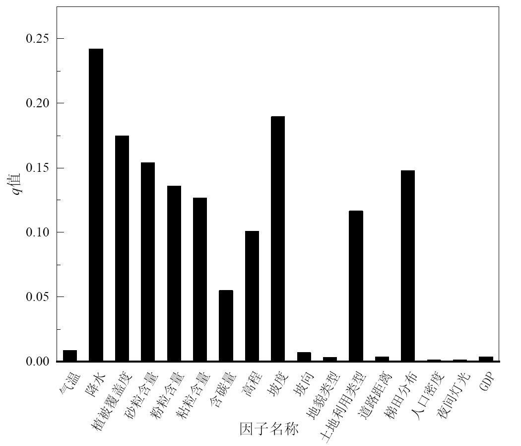
图6 单因子探测结果
Figure 6 Soil erosion modulus single factor detection results
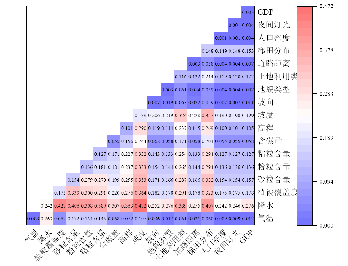
图7 双因子交互探测结果
Figure 7 Soil erosion modulus two-factor interaction detection results
| 因子类型 | 因子名称 | 因子类型或分布范围 | 土壤侵蚀模数 |
|---|---|---|---|
| 气候要素 | 气温 | 0‒5 ℃ | 2.536×10³ |
| 降水 | 500—550 mm | 1.783×10³ | |
| 植被要素 | 植被覆盖度 | 低植被覆盖 | 2.639×10³ |
| 土壤要素 | 砂粒含量 | 45%‒76% | 3.029×10³ |
| 粉粒含量 | 43%‒54% | 1.721×10³ | |
| 粘粒含量 | 21%‒23% | 2.419×10³ | |
| 含碳量 | 1%‒1.95% | 5.766×10³ | |
| 地貌地形要素 | 高程 | 1856‒1941 m | 4.07×10³ |
| 坡度 | 33.1°‒40° | 5.322×10³ | |
| 坡向 | 东 | 1.825×10³ | |
| 地貌类型 | 中起伏山 | 1.912×10³ | |
| 土地利用要素 | 土地利用类型 | 裸地 | 2.3×10³ |
| 距离道路距离 | 11000‒13000 m | 1.788×10³ | |
| 梯田分布密度 | 少量梯田分布 | 2.391×10³ | |
| 社会经济要素 | 人口密度 | 10‒20 person∙km−2 | 1.695×10³ |
| 夜间灯光反射值 | 40‒50 | 4.734×10³ | |
| GDP | 2000‒3000 yuan∙a−1 | 2.887×10³ |
表7 驱动因子高风险区识别
Table 7 Driver risk zone detection results
| 因子类型 | 因子名称 | 因子类型或分布范围 | 土壤侵蚀模数 |
|---|---|---|---|
| 气候要素 | 气温 | 0‒5 ℃ | 2.536×10³ |
| 降水 | 500—550 mm | 1.783×10³ | |
| 植被要素 | 植被覆盖度 | 低植被覆盖 | 2.639×10³ |
| 土壤要素 | 砂粒含量 | 45%‒76% | 3.029×10³ |
| 粉粒含量 | 43%‒54% | 1.721×10³ | |
| 粘粒含量 | 21%‒23% | 2.419×10³ | |
| 含碳量 | 1%‒1.95% | 5.766×10³ | |
| 地貌地形要素 | 高程 | 1856‒1941 m | 4.07×10³ |
| 坡度 | 33.1°‒40° | 5.322×10³ | |
| 坡向 | 东 | 1.825×10³ | |
| 地貌类型 | 中起伏山 | 1.912×10³ | |
| 土地利用要素 | 土地利用类型 | 裸地 | 2.3×10³ |
| 距离道路距离 | 11000‒13000 m | 1.788×10³ | |
| 梯田分布密度 | 少量梯田分布 | 2.391×10³ | |
| 社会经济要素 | 人口密度 | 10‒20 person∙km−2 | 1.695×10³ |
| 夜间灯光反射值 | 40‒50 | 4.734×10³ | |
| GDP | 2000‒3000 yuan∙a−1 | 2.887×10³ |
| [1] | ISLAM M R, JAAFAR W Z W, HIN L S, et al., 2020. Development of an erosion model for Langat River Basin, Malaysia, adapting GIS and RS in RUSLE[J]. Applied Water Science, 10(7): 165. |
| [2] | PHINZI K, NGETAR N S, 2019. The assessment of water-borne erosion at catchment level using GIS-based RUSLE and remote sensing: A review[J]. International Soil and Water Conservation Research, 7(1): 27-46. |
| [3] | RENARD K G, FOSTER G R, WEESIES G A, et al., 1991. RUSLE: Revised universal soil loss equation[J]. Journal of Soil and Water Conservation, 46(1): 30-33. |
| [4] | TAGIL S, 2007. Land degradation risk assessment for Tuzla Creek Basin (Biga Peninsula) using a GIS-based RUSLE model[J]. Ekoloji, 17(65): 11-20. |
| [5] | WILLIAMS J, JONES C, KINIRY J, et al., 1989. The EPIC crop growth model[J]. Transactions of the ASAE, 32(2): 497-511. |
| [6] | WISCHMEIER W H, 1984. The USLE - some reflections[J]. Journal of Soil and Water Conservation, 39(2): 105-107. |
| [7] | 蔡崇法, 丁树文, 史志华, 等, 2000. 应用USLE模型与地理信息系统IDRISI预测小流域土壤侵蚀量的研究[J]. 水土保持学报, 14(2): 19-24. |
| CAI C F, DING S W, SHI Z H, et al., 2000. Study of applying USLE and geographical information system IDRISI to predict soil erosion in small watershed[J]. Journal of Soil and Water Conservation, 14(2): 19-24. | |
| [8] | 柴亚昕, 胡彦婷, 张富, 等, 2022. 基于RUSLE的祖厉河上游会师流域土壤侵蚀及敏感性分析[J]. 草原与草坪, 42(6): 128-135. |
| CHAI Y X, HU Y T, ZHANG F, et al., 2022. Soil erosion and sensitivity analysis in Huishi watershed of Zuli River Upper Reaches based on RUSLE[J]. Grassland and Turf, 42(6): 128-135. | |
| [9] | 陈蝶, 卫伟, 陈利顶, 等, 2016. 梯田生态系统服务与管理研究进展[J]. 山地学报, 34(3): 374-384. |
| CHEN D, WEI W, CHEN L D, et al., 2016. Progress of the ecosystem services and management of terraces[J]. Mountain Research, 34(3): 374-384. | |
| [10] | 傅伯杰, 陈利顶, 马克明, 1999. 黄土丘陵区小流域土地利用变化对生态环境的影响——以延安市羊圈沟流域为例[J]. 地理学报, 54(3): 51-56. |
| FU B J, CHEN L D, MA K M, 1999. The effect of land use change on the regional environment in the yangjuangou catchment in the Loess Plateau of China[J]. Acta Geographica Sinica, 54(3): 51-56. | |
| [11] | 巩杰, 陈利顶, 傅伯杰, 等, 2004. 黄土丘陵区小流域土地利用和植被恢复对土壤质量的影响[J]. 应用生态学报, 15(12): 2292-2296. |
| GONG J, CHEN L D, FU B J, et al., 2004. Effects of land use and vegetation restoration on soil quality in a small catchment of the Loess Plateau[J]. Chinese Journal of Applied Ecology, 15(12) :2292-2296. | |
| [12] | 郭佳昊, 李纯斌, 吴静, 2022. 基于InVEST模型的金塔县土壤侵蚀和土壤保持状况评价[J]. 草原与草坪, 42(5): 106-113. |
| GUO J H, LI C B, WU J, 2022. Research on soil erosion and soil conservation status in Jinta County based on InVEST model[J]. Grassland and Turf, 42(5): 106-113. | |
| [13] | 郭旭东, 陈利顶, 傅伯杰, 1999. 土地利用/土地覆被变化对区域生态环境的影响[J]. 环境工程学报, 7(6): 66-75. |
| GUO X D, CHEN L D, FU B J, 1999. Effects of land use/land cover changes on regional ecological environment[J]. Chinese Journal of Environmental Engineering, 7(6): 66-75. | |
| [14] | 焦金鱼, 贵立德, 2016. 基于GIS的祖厉河流域土壤侵蚀治理模式模拟研究[J]. 水土保持学报, 30(5): 95-101. |
| JIAO J Y, GUI L D, 2016. Control Model of Soil Erosion in Zuli River Basin using GIS method[J]. Journal of Soil and Water Conservation, 30(5): 95-101. | |
| [15] | 李娜, 李雷, 白艳萍, 等, 2022. 祖厉河流域水土流失动态变化研究[J]. 中国水土保持, 43(8): 7-9. |
| LI N, LI L, BAI Y P, et al., 2022. Dynamic Changes of soil and water loss in Zuli River Basin[J]. Soil and Water Conservation in China, 43(8): 7-9. | |
| [16] | 李永红, 高照良, 2011. 黄土高原地区水土流失的特点、危害及治理[J]. 生态经济, 27(8): 148-153. |
| LI Y H, GAO Z L, 2011. The loess plateau area the characteristics of soil and water loss, damages and management[J]. Ecological Economy, 27(8): 148-153. | |
| [17] | 吕一河, 傅伯杰, 2001. 生态学中的尺度及尺度转换方法[J]. 生态学报, 21(12): 2096-2105. |
| LÜ Y H, FU B J, 2001. Ecological scale and scaling[J]. Acta Ecologica Sinica, 21(12): 2096-2105. | |
| [18] | 孟斌, 王劲峰, 张文忠, 等, 2005. 基于空间分析方法的中国区域差异研究[J]. 地理科学, 25(4): 393-400. |
|
MENG B, WANG J F, ZHANG W Z, et al., 2005. Evaluation of regional disparity in China based on spatial analysis[J]. Scientia Geographica Sinica, 25(4): 393-400.
DOI |
|
| [19] | 戚继阳, 张富, 赵传燕, 等, 2018. 基于GIS和RS的称钩河流域土壤侵蚀与土地利用关系分析[J]. 甘肃农业大学学报, 53(2): 94-102. |
| QI J Y, ZHANG F, ZHAO C Y, et al., 2018. Analysis on relationship between soil erosion and land use in Chenggou River Basin based on GIS and RS[J]. Journal of Gansu Agricultural University, 53(2): 94-102. | |
| [20] | 秦伟, 朱清科, 张岩, 2009. 基于GIS和RUSLE的黄土高原小流域土壤侵蚀评估[J]. 农业工程学报, 25(8): 157-163. |
| QIN W, ZHU Q K, ZHANG Y, 2009. Soil erosion assessment of small watershed in Loess Plateau based on GIS and RUSLE[J]. Transactions of the Chinese Society of Agricultural Engineering, 25(8): 157-163. | |
| [21] |
王欢, 高江波, 侯文娟, 2018. 基于地理探测器的喀斯特不同地貌形态类型区土壤侵蚀定量归因[J]. 地理学报, 73(9): 1674-1686.
DOI |
|
WANG H, GAO J B, HOU W J, 2018. Quantitative attribution analysis of soil erosion in different morphological types of geomorphology in karst areas: Based on the geographical detector method[J]. Acta Geographica Sinica, 73(9): 1674-1686.
DOI |
|
| [22] |
王劲峰, 徐成东, 2017. 地理探测器: 原理与展望[J]. 地理学报, 72(1): 116-134.
DOI |
|
WANG J F, XU C D, 2017. Geodetector: Principle and prospective[J]. Acta Geographica Sinica, 72(1): 116-134.
DOI |
|
| [23] | 王晓峰, 贾子续, 冯晓明, 等, 2023. 黄土高原土壤保持服务供需平衡及其驱动因素[J]. 生态学报, 43(7): 2722-2733. |
| WANG X F, JIA Z X, FENG X M, et al., 2023. Analysis on supply and demand balance of soil conservation service and its driving factors on the Loess Plateau[J]. Acta Ecologica Sinica, 43(7): 2722-2733. | |
| [24] | 吴成永, 曹广超, 陈克龙, 等, 2022. 黄河上游地区土壤保持服务时空变化及归因[J]. 水土保持学报, 36(4): 143-150. |
| WU C Y, CAO G C, CHEN K L, et al., 2023. Spatio-temporal variation in soil conservation service and its influencing factors in the upper reaches of the Yellow River[J]. Journal of Soil and Water Conservation, 36(4): 143-150. | |
| [25] | 谢怡凡, 姚顺波, 丁振民, 等, 2022. 退耕还林和地理特征对土壤侵蚀的关联影响——以陕西省107个县区为例[J]. 生态学报, 42(1): 301-312. |
| XIE Y F, YAO S B, DING Z M, et al., 2022. The Grain for Green project, geographical features and soil erosion: Taking 107 counties in Shaanxi Province as examples[J]. Acta Ecologica Sinica, 42(1): 301-312. | |
| [26] |
徐超璇, 鲁春霞, 黄绍琳, 2020. 张家口地区生态脆弱性及其影响因素[J]. 自然资源学报, 35(6): 1288-1300.
DOI |
| XU C X, LU C X, HUANG S L, 2020. Study on ecological vulnerability and its influencing factors in Zhangjiakou area[J]. Journal of Natural Resources, 35(6): 1288-1300. | |
| [27] | 徐静, 杨桂山, 许晨, 等, 2023. 湖库水源地流域生态系统服务权衡与多目标优化——以天目湖流域为例[J]. 长江流域资源与环境, 32(1): 62-70. |
| XU J, YANG G S, XU C, et al., 2023. Trade-offs and multi-objective optimization among ecosystem services in headwater catchments: A case study in Tianmu Lake Catchment[J]. Resources and Environment in the Yangtze Basin, 32(1): 62-70. | |
| [28] | 杨严攀, 田培, 沈晨竹, 等, 2024. 基于RUSLE模型和地理探测器的鄂西南土壤侵蚀脆弱性评价[J]. 水土保持学报, 38(1): 91-103. |
| YANG Y P, TIAN P, SHEN C Z, et al., 2024. Vulnerability assessment of soil erosion in southwestern Hubei Province based on RUSLE model and geographic detector[J]. Journal of Soil and Water Conservation, 38(1): 91-103. | |
| [29] | 姚雄, 余坤勇, 刘健, 等, 2016. 南方水土流失严重区的生态脆弱性时空演变[J]. 应用生态学报, 27(3): 735-45. |
| YAO X, YU K Y, LIU J, et al., 2016. Spatial and temporal changes of the ecological vulnerability in a serious soil erosion area, Southern China[J]. Chinese Journal of Applied Ecology, 27(3): 735-45. | |
| [30] | 张光辉, 刘宝元, 何小武, 2005. 黄土区原状土壤分离过程的水动力学机理研究[J]. 水土保持学报, 19(4): 48-52. |
| ZHANG G H, LIU B Y, HE X W, 2005. Study on hydro-dynamic mechanism of natural soil detachment in loess region[J]. Journal of Soil Water Conservation, 19(4): 48-52. | |
| [31] | 张志斌, 潘晶, 达福文, 2012. 西北地区中小城镇滨水空间生态治理与开发——以会宁县祖厉河城区段概念规划为例[J]. 城市问题, 31(7): 44-48. |
| ZHANG Z B, PAN J, DA F W, 2012. Ecological management and comprehensive development of the waterfront space in the northwest small and medium-sized towns: Taking the concept design for Zuli River in Huining County for an example[J]. Urban Problems, 31(7): 44-48. |
| [1] | 王美娜, 范顺祥, 舒翰俊, 张建杰, 褚力其, 法玉琦. 河南省土壤侵蚀时空分异特征及土壤保持经济价值[J]. 生态环境学报, 2024, 33(5): 730-744. |
| [2] | 田叙辰, 魏洪玲, 解胜男, 储启名, 杨婧, 张颖, 肖思秋, 唐中华, 刘英, 李德文. 基于MaxEnt模型的东北地区槭树潜在地理分布[J]. 生态环境学报, 2024, 33(4): 509-519. |
| [3] | 李霞, 陈永昊, 陈喆, 张国壮, 唐梦雅. 中国沿海地区植被NDVI时空变化及驱动力分析[J]. 生态环境学报, 2024, 33(2): 180-191. |
| [4] | 古佳玮, 郭彩霞, 朱铧楠, 谭玉坤, 陈红跃. 广东丰溪省级自然保护区景观格局变化及其驱动力研究[J]. 生态环境学报, 2024, 33(2): 222-230. |
| [5] | 田成诗, 孙瑞欣. 长江经济带市域生态环境质量空间分异与影响因素分析——基于三生空间的土地利用转型[J]. 生态环境学报, 2023, 32(7): 1173-1184. |
| [6] | 王琳, 卫伟. 黄土高原典型县域生态系统服务变化特征及驱动因素[J]. 生态环境学报, 2023, 32(6): 1140-1148. |
| [7] | 刘霞, 郭澍, 王琳. 区域一体化地区的土地利用与生态服务价值研究——以双莱先行区为例[J]. 生态环境学报, 2023, 32(6): 1163-1172. |
| [8] | 张钧韦, 夏圣洁, 陈慧儒, 刘艳红. 山西中部城市群景观格局演变对其热环境的影响研究[J]. 生态环境学报, 2023, 32(5): 943-955. |
| [9] | 李建辉, 党争, 陈琳. 黄河几字弯都市圈PM2.5时空特征及影响因素分析[J]. 生态环境学报, 2023, 32(4): 697-705. |
| [10] | 王嘉丽, 冯婧珂, 杨元征, 俎佳星, 蔡文华, 杨健. 南宁市主城区不透水面与热环境效应的空间关系研究[J]. 生态环境学报, 2023, 32(3): 525-534. |
| [11] | 王成武, 罗俊杰, 唐鸿湖. 基于InVEST模型的太行山沿线地区生态系统碳储量时空分异驱动力分析[J]. 生态环境学报, 2023, 32(2): 215-225. |
| [12] | 肖成志, 计扬, 李建忠, 张志, 巴仁基, 曹亚廷. 岷江上游生态脆弱性时空分异及驱动因子交互效应分析——以杂谷脑河流域为例[J]. 生态环境学报, 2023, 32(10): 1760-1770. |
| [13] | 叶深, 王鹏, 黄祎, 折远洋, 丁明军. 长三角城市群城市空间形态对PM2.5与O3污染空间异质性特征的影响研究[J]. 生态环境学报, 2023, 32(10): 1771-1784. |
| [14] | 付蓉, 武新梅, 陈斌. 城市地表温度空间分异及驱动因子差异性分析——以合肥市为例[J]. 生态环境学报, 2023, 32(1): 110-122. |
| [15] | 陈文裕, 夏丽华, 徐国良, 余世钦, 陈行, 陈金凤. 2000—2020年珠江流域NDVI动态变化及影响因素研究[J]. 生态环境学报, 2022, 31(7): 1306-1316. |
| 阅读次数 | ||||||
|
全文 |
|
|||||
|
摘要 |
|
|||||