生态环境学报 ›› 2025, Vol. 34 ›› Issue (2): 167-180.DOI: 10.16258/j.cnki.1674-5906.2025.02.001
• 研究论文【生态学】 •
下一篇
张继1,2( ), 杨世琦1,2,*(), 赵磊1,2, 冯介玲1,2, 陈艳英1,2
收稿日期:2024-08-30
出版日期:2025-02-18
发布日期:2025-03-03
通讯作者:
*杨世琦。E-mail: yangshiqi1980@sina.com作者简介:张继(1993年生),男,工程师,硕士,主要从事地理信息系统与遥感。E-mail: zhangji0324@163.com
基金资助:
ZHANG Ji1,2(), YANG Shiqi1,2,*(), ZHAO Lei1,2, FENG Jieling1,2, CHEN Yanying1,2
Received:2024-08-30
Online:2025-02-18
Published:2025-03-03
摘要:
生境质量是反映区域生物多样性和生态系统服务水平的重要指标。在加强生态保护和修复的高质量发展背景下,探究区域生境质量的时空演变特征对于制定针对性的生态保护政策具有重要意义。以重庆市“一带三屏”为研究区,使用众数滤波处理土地利用数据以提高其可靠性,基于InVEST模型计算生境质量并在像元尺度上进行空间自相关分析,从行政和自然单元视角探究了2000-2020年研究区的生境质量时空演变特征。结果表明,1)重庆市土地利用以林地和耕地为主,期间耕地大幅减少,大部分转换为林地。2)多年平均生境质量指数为0.473,在空间分布上呈东北和东南高、西部低的格局,近20年总体呈上升趋势。3)大巴山区生态屏障多年平均生境质量指数最高(0.635);武陵山区(0.557)和大娄山区生态屏障(0.477)次之,其趋势有所下降;长江上游生态保护带最低(0.406),但总体趋势向好。4)生境质量热点区主要集中在大巴山区和武陵山区生态屏障,冷点区位于长江上游生态保护带和大娄山区生态屏障北部;生境质量变化量的显著性热点和冷点面积均呈增加趋势,反映了生态保护与环境破坏的两极分化。研究结果可为研究区的生态保护和修复工作提供数据支持和决策依据。
中图分类号:
张继, 杨世琦, 赵磊, 冯介玲, 陈艳英. 基于InVEST模型的重庆市“一带三屏”生境质量时空演变特征分析[J]. 生态环境学报, 2025, 34(2): 167-180.
ZHANG Ji, YANG Shiqi, ZHAO Lei, FENG Jieling, CHEN Yanying. Spatiotemporal Evolution Characteristics of Habitat Quality in the One Belt and Three Barriers Region of Chongqing City Based on the InVEST Model[J]. Ecology and Environment, 2025, 34(2): 167-180.
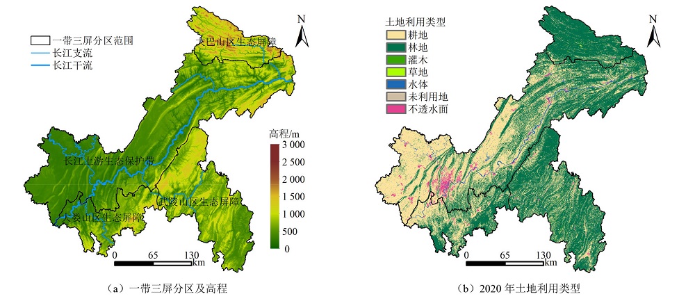
图1 重庆市“一带三屏”位置及2020年土地利用类型分布图
Figure 1 Locations of One Belt and Three Barriers in Chongqing city and distribution of land use types in 2020
| 威胁因子 | 最大胁迫距离/km | 权重 | 衰退类型 |
|---|---|---|---|
| 耕地 | 4 | 0.6 | 线性 |
| 不透水面 | 8 | 0.4 | 指数 |
| 未利用地 | 6 | 0.5 | 线性 |
表1 研究区威胁源影响距离及其权重
Table 1 Impact distances and weights of threat sources in the studied area
| 威胁因子 | 最大胁迫距离/km | 权重 | 衰退类型 |
|---|---|---|---|
| 耕地 | 4 | 0.6 | 线性 |
| 不透水面 | 8 | 0.4 | 指数 |
| 未利用地 | 6 | 0.5 | 线性 |
| 土地利用类型 | 生境适宜性 | 对胁迫因子的敏感度 | ||
|---|---|---|---|---|
| 耕地 | 不透水面 | 未利用地 | ||
| 耕地 | 0.3 | 0 | 0.8 | 0.4 |
| 林地 | 1 | 0.6 | 0.4 | 0.2 |
| 灌木 | 0.9 | 0.7 | 0.5 | 0.4 |
| 草地 | 0.8 | 0.8 | 0.6 | 0.6 |
| 水体 | 0.7 | 0.5 | 0.4 | 0.2 |
| 不透水面 | 0 | 0 | 0 | 0 |
| 未利用地 | 0 | 0 | 0 | 0 |
表2 研究区不同土地利用类型对生境威胁因子的敏感度
Table 2 Habitat suitability of different land use types and sensitivity to threat factors in studied area
| 土地利用类型 | 生境适宜性 | 对胁迫因子的敏感度 | ||
|---|---|---|---|---|
| 耕地 | 不透水面 | 未利用地 | ||
| 耕地 | 0.3 | 0 | 0.8 | 0.4 |
| 林地 | 1 | 0.6 | 0.4 | 0.2 |
| 灌木 | 0.9 | 0.7 | 0.5 | 0.4 |
| 草地 | 0.8 | 0.8 | 0.6 | 0.6 |
| 水体 | 0.7 | 0.5 | 0.4 | 0.2 |
| 不透水面 | 0 | 0 | 0 | 0 |
| 未利用地 | 0 | 0 | 0 | 0 |
| 生态规划区 | 年份 | 面积占比/% | ||||||
|---|---|---|---|---|---|---|---|---|
| 耕地 | 林地 | 灌木 | 草地 | 水体 | 不透水面 | 未利用地 | ||
| 重庆市 | 2000 | 47.0 | 50.0 | 1.2 | 0.2 | 1.0 | 0.6 | 0.0 |
| 2005 | 46.0 | 50.7 | 1.2 | 0.1 | 1.1 | 0.8 | 0.0 | |
| 2010 | 43.5 | 52.8 | 1.2 | 0.1 | 1.3 | 1.1 | 0.0 | |
| 2015 | 44.7 | 51.7 | 0.5 | 0.1 | 1.4 | 1.6 | 0.0 | |
| 2020 | 42.3 | 54.0 | 0.3 | 0.1 | 1.3 | 2.0 | 0.0 | |
| 长江上游生态保护带 | 2000 | 64.5 | 32.4 | 0.4 | 0.2 | 1.5 | 1.0 | 0.0 |
| 2005 | 62.4 | 34.0 | 0.6 | 0.1 | 1.7 | 1.2 | 0.0 | |
| 2010 | 58.2 | 37.3 | 0.7 | 0.1 | 2.0 | 1.7 | 0.0 | |
| 2015 | 58.8 | 36.3 | 0.2 | 0.1 | 2.1 | 2.4 | 0.0 | |
| 2020 | 55.6 | 39.2 | 0.1 | 0.0 | 2.1 | 3.0 | 0.0 | |
| 大巴山区生态屏障 | 2000 | 11.4 | 85.5 | 2.0 | 1.0 | 0.0 | 0.2 | 0.0 |
| 2005 | 10.4 | 87.6 | 1.2 | 0.6 | 0.0 | 0.2 | 0.0 | |
| 2010 | 10.0 | 88.6 | 0.7 | 0.5 | 0.0 | 0.2 | 0.0 | |
| 2015 | 9.9 | 88.9 | 0.4 | 0.4 | 0.1 | 0.3 | 0.0 | |
| 2020 | 9.2 | 89.7 | 0.3 | 0.3 | 0.1 | 0.3 | 0.0 | |
| 武陵山区生态屏障 | 2000 | 23.7 | 72.8 | 3.0 | 0.1 | 0.2 | 0.2 | 0.0 |
| 2005 | 23.4 | 72.9 | 3.2 | 0.1 | 0.2 | 0.2 | 0.0 | |
| 2010 | 23.0 | 73.7 | 2.7 | 0.1 | 0.3 | 0.3 | 0.0 | |
| 2015 | 26.6 | 71.4 | 1.2 | 0.1 | 0.3 | 0.4 | 0.0 | |
| 2020 | 24.8 | 73.5 | 0.8 | 0.0 | 0.3 | 0.5 | 0.0 | |
| 大娄山区生态屏障 | 2000 | 43.6 | 54.5 | 0.3 | 0.0 | 1.0 | 0.4 | 0.0 |
| 2005 | 47.1 | 50.8 | 0.5 | 0.0 | 1.0 | 0.6 | 0.0 | |
| 2010 | 45.8 | 51.3 | 1.0 | 0.0 | 1.0 | 0.9 | 0.0 | |
| 2015 | 46.0 | 51.2 | 0.4 | 0.0 | 1.0 | 1.3 | 0.0 | |
| 2020 | 45.4 | 51.6 | 0.2 | 0.0 | 1.0 | 1.7 | 0.0 | |
表3 2000-2020年重庆市“一带三屏”土地利用类型面积占比
Table 3 Proportional area of land use types in Chongqing’s One Belt and Three Barriers from 2000 to 2020
| 生态规划区 | 年份 | 面积占比/% | ||||||
|---|---|---|---|---|---|---|---|---|
| 耕地 | 林地 | 灌木 | 草地 | 水体 | 不透水面 | 未利用地 | ||
| 重庆市 | 2000 | 47.0 | 50.0 | 1.2 | 0.2 | 1.0 | 0.6 | 0.0 |
| 2005 | 46.0 | 50.7 | 1.2 | 0.1 | 1.1 | 0.8 | 0.0 | |
| 2010 | 43.5 | 52.8 | 1.2 | 0.1 | 1.3 | 1.1 | 0.0 | |
| 2015 | 44.7 | 51.7 | 0.5 | 0.1 | 1.4 | 1.6 | 0.0 | |
| 2020 | 42.3 | 54.0 | 0.3 | 0.1 | 1.3 | 2.0 | 0.0 | |
| 长江上游生态保护带 | 2000 | 64.5 | 32.4 | 0.4 | 0.2 | 1.5 | 1.0 | 0.0 |
| 2005 | 62.4 | 34.0 | 0.6 | 0.1 | 1.7 | 1.2 | 0.0 | |
| 2010 | 58.2 | 37.3 | 0.7 | 0.1 | 2.0 | 1.7 | 0.0 | |
| 2015 | 58.8 | 36.3 | 0.2 | 0.1 | 2.1 | 2.4 | 0.0 | |
| 2020 | 55.6 | 39.2 | 0.1 | 0.0 | 2.1 | 3.0 | 0.0 | |
| 大巴山区生态屏障 | 2000 | 11.4 | 85.5 | 2.0 | 1.0 | 0.0 | 0.2 | 0.0 |
| 2005 | 10.4 | 87.6 | 1.2 | 0.6 | 0.0 | 0.2 | 0.0 | |
| 2010 | 10.0 | 88.6 | 0.7 | 0.5 | 0.0 | 0.2 | 0.0 | |
| 2015 | 9.9 | 88.9 | 0.4 | 0.4 | 0.1 | 0.3 | 0.0 | |
| 2020 | 9.2 | 89.7 | 0.3 | 0.3 | 0.1 | 0.3 | 0.0 | |
| 武陵山区生态屏障 | 2000 | 23.7 | 72.8 | 3.0 | 0.1 | 0.2 | 0.2 | 0.0 |
| 2005 | 23.4 | 72.9 | 3.2 | 0.1 | 0.2 | 0.2 | 0.0 | |
| 2010 | 23.0 | 73.7 | 2.7 | 0.1 | 0.3 | 0.3 | 0.0 | |
| 2015 | 26.6 | 71.4 | 1.2 | 0.1 | 0.3 | 0.4 | 0.0 | |
| 2020 | 24.8 | 73.5 | 0.8 | 0.0 | 0.3 | 0.5 | 0.0 | |
| 大娄山区生态屏障 | 2000 | 43.6 | 54.5 | 0.3 | 0.0 | 1.0 | 0.4 | 0.0 |
| 2005 | 47.1 | 50.8 | 0.5 | 0.0 | 1.0 | 0.6 | 0.0 | |
| 2010 | 45.8 | 51.3 | 1.0 | 0.0 | 1.0 | 0.9 | 0.0 | |
| 2015 | 46.0 | 51.2 | 0.4 | 0.0 | 1.0 | 1.3 | 0.0 | |
| 2020 | 45.4 | 51.6 | 0.2 | 0.0 | 1.0 | 1.7 | 0.0 | |
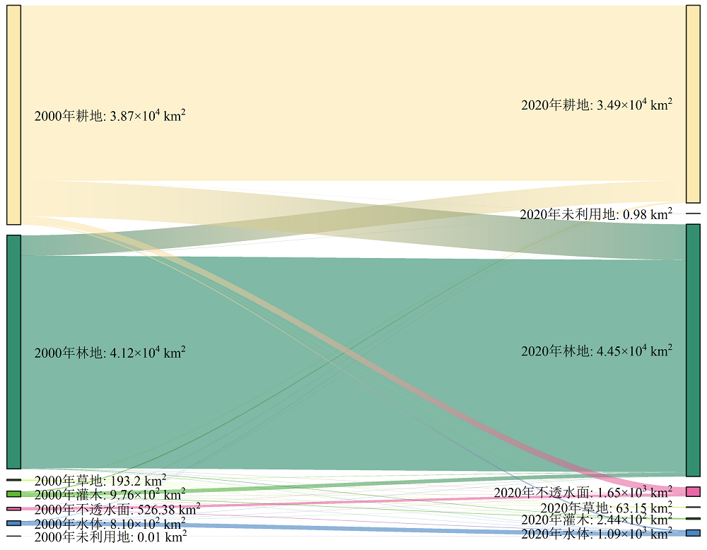
图2 2000-2020年研究区土地利用转移桑基图
Figure 2 Sankey diagram of land use transition matrix in the studied area from 2000 to 2020

图3 2000-2020年重庆市“一带三屏”生境质量指数空间分布图
Figure 3 Spatial distribution of habitat quality in Chongqing’s One Belt and Three Barriers from 2000 to 2020
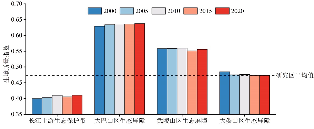
图4 2000-2020年重庆市“一带三屏”生境质量指数变化
Figure 4 Changes in habitat quality in Chongqing's One Belt and Three Barriers from 2000 to 2020
| 年份 | Moran's I | 显著性(Z值) |
|---|---|---|
| 2000 | 0.893 | 1.71×10⁴ |
| 2005 | 0.898 | 1.72×10⁴ |
| 2010 | 0.899 | 1.72×10⁴ |
| 2015 | 0.896 | 1.71×10⁴ |
| 2020 | 0.899 | 1.72×10⁴ |
表4 2000-2020年重庆市“一带三屏”生境质量的空间自相关性
Table 4 Spatial autocorrelation of habitat quality in Chongqing's One Belt and Three Barriers from 2000 to 2020
| 年份 | Moran's I | 显著性(Z值) |
|---|---|---|
| 2000 | 0.893 | 1.71×10⁴ |
| 2005 | 0.898 | 1.72×10⁴ |
| 2010 | 0.899 | 1.72×10⁴ |
| 2015 | 0.896 | 1.71×10⁴ |
| 2020 | 0.899 | 1.72×10⁴ |

图5 研究区不同时期生境质量热点和冷点的空间分布
Figure 5 Spatial distribution of habitat quality hotspots and coldspots in the studied area in different periods

图6 研究区不同时期生境质量变化量的热点和冷点空间分布
Figure 6 Spatial distribution of hotspots and coldspots of habitat quality change in the studied area in different periods
| [1] | AKBARI A, PITTMAN J, FEICK R, 2021. Mapping the relative habitat quality values for the burrowing owls (Athene cunicularia) of the Canadian prairies using an innovative parameterization approach in the InVEST HQ module[J]. Environmental Management, 68(3): 310-328. |
| [2] | CUI P P, CHEN T, LI Y J, et al., 2023. Comparison and assessment of different land cover datasets on the cropland in Northeast China[J]. Remote Sensing, 15(21): 5134. |
| [3] | GOERTZ J W, 1964. The influence of habitat quality upon density of cotton rat populations[J]. Ecological Monographs, 34(4): 359-381. |
| [4] | HONG H J, KIM C K, LEE H W, et al., 2021. Conservation, restoration, and sustainable use of biodiversity based on habitat quality monitoring: A case study on Jeju Island, South Korea (1989-2019)[J]. Land, 10(8): 774. |
| [5] | JI X Y, HAN X J, ZHU X B, et al., 2024. Comparison and validation of multiple medium- and high-resolution land cover products in Southwest China[J]. Remote Sensing, 16(6): 1111. |
| [6] | KRAUSMAN P R, 1999. Some basic principles of habitat use[J]. Grazing Behavior of Livestock and Wildlife, 70: 85-90. |
| [7] | LI S N, CONGMOU Z, LI Y J, et al., 2023. Agricultural space function transitions in rapidly urbanizing areas and their impacts on habitat quality: An urban-rural gradient study[J]. Environmental Impact Assessment Review, 99: 107019. |
| [8] | LIU S S, LIAO Q P, XIAO M Z, et al., 2022. Spatial and temporal variations of habitat quality and its response of landscape dynamic in the Three Gorges Reservoir area, China[J]. International Journal of Environmental Research and Public Health, 19(6): 3594. |
| [9] | LIU X J, QIN J J, XU Y, et al., 2019. Biodiversity decline of fish assemblages after the impoundment of the Three Gorges Dam in the Yangtze River Basin, China[J]. Reviews in Fish Biology and Fisheries, 29(1): 177-195. |
| [10] | NEWBOLD T, HUDSON L N, HILL S L, et al., 2015. Global effects of land use on local terrestrial biodiversity[J]. Nature, 520(7545): 45-50. |
| [11] | Natural Capital Project, 2024. InVEST user’s guide[EB/OL]. [2024-11-22]. http://releases.naturalcapitalproject.org/invest-userguide/latest/en/index.html. |
| [12] |
XU L Y, YIN H, LI Z X, et al., 2014. Land ecological security evaluation of Guangzhou, China[J]. International Journal of Environmental Research and Public Health, 11(10): 10537-10558.
DOI PMID |
| [13] | YANG J, HUANG X, 2021. The 30 m annual land cover dataset and its dynamics in China from 1990 to 2019[J]. Earth System Science Data, 13(8): 3907-3925. |
| [14] | YAO J, JIN S G, 2022. Long-term changes of land use and land cover in the Yangtze River Basin from 1990-2020 Landsat data[J]. Photogrammetric Engineering & Remote Sensing, 88(9): 573-582. |
| [15] | 安敏, 李文佳, 吴海林, 等, 2022. 三峡库区生态环境质量的时空格局演变及影响因素[J]. 长江流域资源与环境, 31(12): 2743-2755. |
| AN M, LL W J, WU H L, et al., 2022. The evolution and influencing factors of the spatial-temporal pattern of ecological environment quality in the Three Gorges Reservoir area[J]. Resources and Environment in the Yangtze Basin, 31(12): 2743-2755. | |
| [16] | 城口县人民政府, 2017. 城口县人民政府关于印发重庆大巴山国家级自然保护区管理办法的通知[EB/OL]. [2017-07-19]. http://www.cqck.gov.cn/zwgk_270/zcwj/xzgfxwj/201707/t20170721_6924065.html. |
| Chengkou County People’s Government, 2017. Notice of the Chengkou County People’s Government on the issuance of the management regulations for the Chongqing Daba Mountains National Nature Reserve[EB/OL]. [2017-07-19]. http://www.cqck.gov.cn/zwgk_270/zcwj/xzgfxwj/201707/t20170721_6924065.html. | |
| [17] | 重庆市发展和改革委员会, 重庆规划和自然资源局, 2021. 重庆市发展和改革委员会、重庆市规划和自然资源局关于印发《重庆市重要生态系统保护和修复重大工程总体规划(2021- 2035年)》的通知[EB/OL]. [2021-07-06]. https://fzggw.cq.gov.cn/zwxx/tzgg/202107/t20210706_9453386_wap.html. |
| Chongqing Development and Reform Commission, Chongqing Planning and Natural Resources Bureau, 2021. Notice of the Chongqing Development and Reform Commission and the Chongqing Planning and Natural Resources Bureau on the issuance of the general plan for the protection and restoration of major ecosystem projects in Chongqing (2021-2035)[EB/OL]. [2021-07-06]. https://fzggw.cq.gov.cn/zwxx/tzgg/202107/t20210706_9453386_wap.html. | |
| [18] |
戴云哲, 李江风, 杨建新, 2018. 长沙都市区生境质量对城市扩张的时空响应[J]. 地理科学进展, 37(10): 1340-1351.
DOI |
|
DAI Y Z, LI J G, YANG J X, 2018. Spatiotemporal responses of habitat quality to urban sprawl in the Changsha metropolitan area[J]. Progress in Geography, 37(10): 1340-1351.
DOI |
|
| [19] |
黄鑫, 程文仕, 李晓丹, 等, 2020. 甘肃省生境质量变化的图谱特征[J]. 应用生态学报, 31(9): 3131-3140.
DOI |
|
HUANG X, CHENG W S, LI X D, et al., 2020. Spectrum characteristics of habitat quality changes in Gansu Province, China[J]. Chinese Journal of Applied Ecology, 31(9): 3131-3140.
DOI |
|
| [20] | 贾勇, 安一博, 董智, 等, 2024. 重庆市梁平区松材线虫病防治与疫木处置实践与成效[J]. 南方农业, 18(7): 266-273. |
| JIA Y, AN Y B, DONG Z, et al., 2024. Practice and effectiveness of prevention and control of pine wilt disease and management of infected trees in Liangping District, Chongqing City[J]. South China Agriculture, 18(7): 266-273. | |
| [21] |
雷金睿, 陈毅青, 陈宗铸, 等, 2022. 基于InVEST模型的海南岛三大流域生境质量时空演变[J]. 应用生态学报, 33(9): 2511-2520.
DOI |
| LEI J R, CHEN Y Q, CHEN Z Z, et al., 2022. Spatiotemporal evolution of habitat quality in three basins of Hainan Island based on InVEST model[J]. Chinese Journal of Applied Ecology, 33(9): 2511-2520. | |
| [22] | 李慧, 魏兴萍, 蔡云丽, 等, 2024. 重庆石漠化和非石漠化区植被绿度时空变化特征[J]. 水土保持学报, 38(3): 288-297. |
| LI H, WEI X P, CAI Y L, et al., 2024. Spatial and temporal variation characteristics of vegetation greenness in rocky desertification and non-rocky desertification areas of Chongqing[J]. Journal of Soil and Water Conservation, 38(3): 288-297. | |
| [23] |
刘春芳, 王川, 刘立程, 2018. 三大自然区过渡带生境质量时空差异及形成机制——以榆中县为例[J]. 地理研究, 37(2): 419-432.
DOI |
| LIU C F, WANG C, LIU L C, 2018. Spatio-temporal variation on habitat quality and its mechanism within the transitional area of the Three Natural Zones: A case study in Yuzhong county[J]. Geographical Research, 37(2): 419-432. | |
| [24] | 刘婷, 邓伟, 周渝, 等, 2020. 重庆市 “一区两群” 生境质量及其地形梯度分异[J]. 环境科学与技术, 43(11): 227-236. |
| LIU T, DENG W, ZHOU Y, et al., 2020. Habitat quality and terrain gradient differentiation of “One Urban Area and Two Town Groups” in Chongqing[J]. Environmental Science & Technology, 43(11): 227-236. | |
| [25] | 刘智方, 唐立娜, 邱全毅, 等, 2017. 基于土地利用变化的福建省生境质量时空变化研究[J]. 生态学报, 37(13): 4538-4548. |
| LIU Z F, TANG L N, QIU Q Y, et al., 2017. Temporal and spatial changes in habitat quality based on land-use change in Fujian Province[J]. Acta Ecologica Sinica, 37(13): 4538-4548. | |
| [26] |
麻学锋, 张艳芳, 2022. 山地旅游区空间聚散效应及影响因素分析——以武陵山片区为例[J]. 中国生态旅游, 12(6): 923-937.
DOI |
|
MA X F, ZHANG Y F, 2022. Research on the spatial aggregation-diffusivity effect and analysis of its influencing factors in mountainous tourism area: A case study of Wuling Mountain area[J]. Journal of Chinese Ecotourism, 12(6): 923-937.
DOI |
|
| [27] | 彭建, 吴见, 徐飞雄, 等, 2021. 基于价值评估的黄山市生境质量时空演变特征分析[J]. 生态学报, 41(2): 665-679. |
| PENG J, WU J, XU F X, et al., 2021. Spatio-temporal evolution characteristics of habitat quality in typical tourism cities based on value evaluation: A case study of Huangshan[J]. Acta Ecologica Sinica, 41(2): 665-679. | |
| [28] | 欧阳志云, 刘建国, 肖寒, 等, 2001. 卧龙自然保护区大熊猫生境评价[J]. 生态学报, 21(11): 1869-1874. |
| OUYANG Z Y, LIU J G, XIAO H, et al., 2001. An assessment of giant panda habitat in Wolong Nature Reserve[J]. Acta Ecologica Sinica, 21(11): 1869-1874. | |
| [29] | 齐静, 郭宇, 黄大楠, 2023. 重庆市生态产品总值 (GEP) 核算与变化特征研究[J]. 环境生态学, 5(9): 53-60. |
| QI J, GUO Y, HUANG D N, 2023. Study on the accounting and change characteristics of gross ecosystem product (GEP) in Chongqing[J]. Environmental Ecology, 5(9):53-60. | |
| [30] | 冉棋月, 米潭, 詹宇, 等, 2023. 基于InVEST模型的重庆市碳储量不确定性分析[J]. 环境科学与技术, 46(11): 59-68. |
| RAN Q Y, MI T, ZHAN Y, et al., 2023. Uncertainty analysis of carbon storage in Chongqing based on InVEST model[J]. Environmental Science & Technology, 46(11): 59-68. | |
| [31] | 苏敬, 芮菡艺, 朱沁园, 等, 2023. 基于InVEST模型的1985-2020年忻州市生境质量演变及地形效应[J]. 生态与农村环境学报, 39(12): 1525-1533. |
| SU J, RUI H Y, ZHU Q Y, et al., 2023. Temporal and spatial evolution of habitat quality and its topographic gradient effect in Xinzhou city based on InVEST model from 1985 to 2020[J]. Journal of Ecology and Rural Environment, 39(12): 1525-1533. | |
| [32] | 孙彦, 蔺星娜, 李生, 等, 2024. 贵州省生态系统服务权衡时空动态与驱动因子评估[J]. 环境科学学报, 44(9): 401-413. |
| SUN Y, LIN X N, LI S, et al., 2024. Spatiotemporal dynamics and driving factor assessment of ecosystem service trade-offs in Guizhou Province[J]. Acta Scientiae Circumstantiae, 44(9): 401-413. | |
| [33] | 万其林, 邵景安, 2023. 2000-2020年三峡库区重庆段土地利用及碳储量估算[J]. 重庆师范大学学报 (自然科学版), 40(6): 52-64. |
| WAN Q L, SHAO J A, 2023. land use and carbon storage estimation in the Chongqing section of the Three Gorges Reservoir Area from 2000 to 2020[J]. Journal of Chongqing Normal University (Natural Science), 40(6): 52-64. | |
| [34] |
王琦琨, 武玮, 杨雪琪, 等, 2022. 陕西省生境质量时空演变及驱动机制分析[J]. 干旱区研究, 39(5): 1684-1694.
DOI |
|
WANG Q K, WU W, YANG X Q, et al., 2022. Spatial-temporal changes and driving factors of habitat quality in Shaanxi Province during the past 20 years[J]. Arid Zone Research, 39(5): 1684-1694.
DOI |
|
| [35] | 王兆林, 张露洋, 钟溦懿, 等, 2023. 三峡库区生态空间脆弱性时空演变特征[J]. 水土保持研究, 30(1): 348-355. |
| WANG Z L, ZHANG L Y, ZHONG W Y, et al., 2023. Temporal and spatial evolution characteristics of ecological space vulnerability in Three Gorges Teservoir Area[J]. Research of Soil and Water Conservatlon, 30(1): 348-355. | |
| [36] | 王彤, 易桂花, 张廷斌, 等, 2023. 西南三江流域生境质量时空格局及其地形梯度效应[J]. 水土保持研究, 30(5): 306-314. |
| WANG T, YI G H, ZHANG T B, et al., 2023. Spatial and temporal pattern of habitat quality and its topographic gradient effect in the Three-River Basin of Southwest China[J]. Research of Soil and Water Conservat1on, 30(5): 306-314. | |
| [37] |
王耕, 王佳雯, 2021. 丹东沿海地区土地利用变化对生境质量的影响研究[J]. 生态环境学报, 30(3): 621-630.
DOI |
| WANG G, WANG J W, 2021. Study on the impact of land use change on habitat quality in Dandong coastal area[J]. Ecology and Environmental Sciences, 30(3): 621-630. | |
| [38] | 吴巧丽, 张鑫阳, 蒋捷, 2023. 基于MODIS和CLCD数据的黄土高原土地利用变化检测及其对植被碳吸收模拟的影响[J]. 地理与地理信息科学, 39(5): 30-38. |
| WU Q L, ZHANG X Y, JIANG J, 2023. Land-Use and Land-Cover change (LUCC) detection based on MODIS and CLCD data and it impact on the simulation of vegetation gross carbon assimilation in the Loess Plateau[J]. Geography and Geo Information Science, 39(5): 30-38. | |
| [39] |
徐炜, 马志远, 井新, 等, 2016. 生物多样性与生态系统多功能性:进展与展望[J]. 生物多样性, 24(1): 55-71.
DOI |
|
XU W, MA Z Y, JING X, et al., 2016. Biodiversity and ecosystem multifunctionality: advances and perspectives[J]. Biodiversity Science, 24(1): 55-71.
DOI |
|
| [40] |
闫宇星, 杨园园, 王永生, 等, 2023. 近40年京津冀地区生境质量变化趋势与归因分析[J]. 遥感技术与应用, 38(2): 251-263.
DOI |
| YAN Y X, YANG Y Y, WANG Y S, et al., 2023. Trends and attribution analysis of habitat quality changes in Beijing-Tianjin-Hebei region over the past 40 years[J]. Remote Sensing Technology and Application, 38(2): 251-263. | |
| [41] | 岳文泽, 夏皓轩, 吴桐, 等, 2022. 浙江省生境质量时空演变与生态红线评估[J]. 生态学报, 42(15): 6406-6417. |
| YUE W Z, XIA H X, WU T, et al., 2022. Spatio-temporal evolution of habitat quality and ecological red line assessment in Zhejiang Province[J]. Acta Ecologica Sinica, 42(15): 6406-6417. | |
| [42] | 叶勤玉, 杨世琦, 张强, 等, 2022. 三峡库区 (重庆段) 水源涵养功能遥感监测及时空分布特征分析[J]. 自然资源遥感, 34(2): 184-193. |
| YE Q Y, YANG S Q, ZHANG Q, et al., 2022. Analysis on water conservation function using remote sensing method in the Three Gorges Reservoir area (Chongqing section)[J]. Remote Sensing for Natural Resources, 34(2): 184-193. | |
| [43] |
张桥英, 吴勇, 2018. 大巴山国家地质公园珍稀濒危植物资源[J]. 生态环境学报, 27(11): 2011-2016.
DOI |
| ZHANG Q Y, WU Y, 2018. Rare and endangered plants in Dabashan National Geopark[J]. Ecology and Environmental Sciences, 27(11): 2011-2016. | |
| [44] |
张学儒, 周杰, 李梦梅, 2020. 基于土地利用格局重建的区域生境质量时空变化分析[J]. 地理学报, 75(1): 160-178.
DOI |
|
ZHANG X R, ZHOU J, LI M M, 2020. Analysis on spatial and temporal changes of regional habitat quality based on the spatial pattern reconstruction of land use[J]. Acta Geographica Sinica, 75(1): 160-178.
DOI |
|
| [45] | 郑贱成, 谢炳庚, 游细斌, 2022a. 1980-2020年粤港澳大湾区生境质量变化特征[J]. 经济地理, 42(8): 41-50. |
| ZHENG J C, XIE B G, YOU X B, 2022a. Evolution of habitat quality and its influencing factors in the different terrain gradient of the guangdong-hong kong-macao greater bay area from 1980 to 2020[J]. Economic Geography, 42(8): 41-50. | |
| [46] | 郑贱成, 谢炳庚, 游细斌, 2022b. 基于土地利用变化的广东省生境质量时空演变特征[J]. 生态学报, 42(17): 6997-7010. |
| ZHENG J C, XIE B G, YOU X B, 2022b. Spatio-temporal characteristics of habitat quality based on land-use changes in Guangdong Province[J]. Acta Ecologica Sinica, 42(17): 6997-7010. | |
| [47] | 郑亚平, 张俊华, 田惠文, 等, 2024. 大别山区生境质量时空特征及自然-人为因素驱动机制[J]. 环境科学, 45(4): 2268-2279. |
| ZHENG Y P, ZHANG J H, TIAN H W, et al., 2024. Spatio-temporal characteristics of habitat quality and natural-human driven mechanism in Dabie Mountain area[J]. Environmental Science, 45(4): 2268-2279. | |
| [48] | 周晓艳, 何依依, 黄欣, 等, 2021. 三峡库区生境质量的地形梯度效应及对土地利用变化的响应[J]. 农业工程学报, 37(11): 259-267. |
| ZHOU X Y, HE Y Y, HUANG X, et al., 2021. Topographic gradient effects of habitat quality and its response to land use change in Hubei Section of the Three Gorges Reservoir[J]. Transactions of the Chinese Society of Agricultural Engineering, 37(11): 259-267. | |
| [49] | 左黎韵, 2022. 重庆发布市域内国家重点保护野生动植物种数[N]. 重庆日报, 2022-03-04( 8). |
| ZUO L Y, 2022. Number of nationally protected wild plant and animal species in Chongqing[N]. Chongqing Daily, 2022-03-04( 8). |
| [1] | 马月伟, 陈玉美, 张盛蓝, 桂雅丽, 陈艳梅. 夹金山脉大熊猫栖息地生境质量与人类活动强度耦合协调研究[J]. 生态环境学报, 2025, 34(2): 197-208. |
| [2] | 唐建亭, 袁杰, 陈宗颜, 李晓燕, 孙子婷. 祁连山南坡土地利用变化及碳储量研究[J]. 生态环境学报, 2024, 33(9): 1353-1361. |
| [3] | 张雯, 郑天, 刘永超, 钟捷, 苏杰, 李加林. 基于电路理论的浙江省生态保护修复关键区域识别[J]. 生态环境学报, 2024, 33(9): 1482-1494. |
| [4] | 王雯, 侯青青, 裴婷婷. 甘肃河东地区坡度对生态系统服务的影响及其阈值效应[J]. 生态环境学报, 2024, 33(7): 1117-1129. |
| [5] | 李海燕, 杨涛, 廖依琳, 屈亚婕. 渭河流域(陕西段)河流生境质量分布格局及驱动力分析[J]. 生态环境学报, 2024, 33(7): 1153-1162. |
| [6] | 徐梓津, 张雪松, 陈明曼. 山地岩溶区生态系统服务时空演变特征分析——以贵州省为例[J]. 生态环境学报, 2023, 32(7): 1196-1206. |
| [7] | 许静, 廖星凯, 甘崎旭, 周茅先. 基于MSPA与电路理论的黄河流域甘肃段生态安全格局构建[J]. 生态环境学报, 2023, 32(4): 805-813. |
| [8] | 张平江, 党国锋. 基于MCR模型与蚁群算法的洮河流域生态安全格局构建[J]. 生态环境学报, 2023, 32(3): 481-491. |
| [9] | 王成武, 罗俊杰, 唐鸿湖. 基于InVEST模型的太行山沿线地区生态系统碳储量时空分异驱动力分析[J]. 生态环境学报, 2023, 32(2): 215-225. |
| [10] | 陈乐, 卫伟. 西北旱区典型流域土地利用与生境质量的时空演变特征[J]. 生态环境学报, 2022, 31(9): 1909-1918. |
| [11] | 王超越, 郭先华, 郭莉, 白丽芳, 夏利林, 王春博, 李廷真. 基于FLUS-InVEST的西北地区土地利用变化及其对碳储量的影响——以呼包鄂榆城市群为例[J]. 生态环境学报, 2022, 31(8): 1667-1679. |
| [12] | 齐静, 邓伟, 周渝, 刘婷, 罗旭. 重庆市生态保护红线成效评估方法与应用[J]. 生态环境学报, 2021, 30(7): 1532-1540. |
| 阅读次数 | ||||||
|
全文 |
|
|||||
|
摘要 |
|
|||||