生态环境学报 ›› 2022, Vol. 31 ›› Issue (11): 2216-2224.DOI: 10.16258/j.cnki.1674-5906.2022.11.013
刘志坚1,2( ), 董元华2, 张琇3, 卿成实4
收稿日期:2022-06-13
出版日期:2022-11-18
发布日期:2022-12-22
作者简介:刘志坚(1987年生),男,高级工程师,硕士,研究方向为环境地质。E-mail: Pannotia@qq.com
基金资助:
LIU Zhijian1,2(), DONG Yuanhua2, ZHANG Xiu3, QING Chengshi4
Received:2022-06-13
Online:2022-11-18
Published:2022-12-22
摘要:
卫宁平原是黄河流域上游的生态保护关键带,也是著名地理标志产品“中宁枸杞”的唯一原产地,在此开展区域性土壤重金属污染及潜在生态风险评价,对改善土壤生态系统功能,保护优质特色农业具有重要意义。该研究以卫宁平原农用地为主要研究对象,采集2830件表层土壤样品,检测As、Cd、Cr、Cu、Hg、Ni、Pb、Zn共8项重金属元素与Al、Li、Sc、Ti共4项地壳稳定元素的含量。运用标准化法计算重金属元素的基线值,并以此作为污染评价模型的参照值;采用污染负荷指数法和Hakanson潜在生态风险指数法研究农用地土壤重金属的污染程度和生态风险,基于空间分析阐明土壤重金属污染的空间分布格局。结果表明:卫宁平原表层土壤中As、Cd、Cr、Cu、Hg、Ni、Pb、Zn的环境地球化学基线值分别为14.51、0.29、79.61、0.05、34.57、26.42、23.95、73.49 mg·kg-1,土壤重金属平均含量均高于黄河流域土壤背景值;污染评价结果表明,土壤As、Cr、Ni污染程度较低,Cu、Pb、Zn污染程度较高,Cd、Hg污染程度最高,综合污染负荷指数总体以轻度污染为主;土壤重金属综合潜在生态风险以中度风险为主,Cd与Hg是导致潜在生态风险程度较高的最主要因子。空间分析表明,污染地块集中分布在城市-农用地交错带和工业园区-农用地交错带;密集的交通运输活动、钢铁冶炼和金属材料加工制造排放的废气及烟尘是土壤Cd、Cu、Pb和Zn污染的主要来源,乡镇企业及工业园区钢铁冶炼生产中的燃煤烟尘是土壤Hg污染的主要来源。该研究结果划定了因人为源输入而造成的重金属污染地块范围,可为黄河流域土壤重金属污染防治提供重要的数据支撑。
中图分类号:
刘志坚, 董元华, 张琇, 卿成实. 卫宁平原农用地土壤重金属污染特征与生态风险研究[J]. 生态环境学报, 2022, 31(11): 2216-2224.
LIU Zhijian, DONG Yuanhua, ZHANG Xiu, QING Chengshi. Contamination and Ecological Risk Assessment of Heavy Metals in the Soil of Agricultural Land in Weining Plain, Northwest China[J]. Ecology and Environment, 2022, 31(11): 2216-2224.
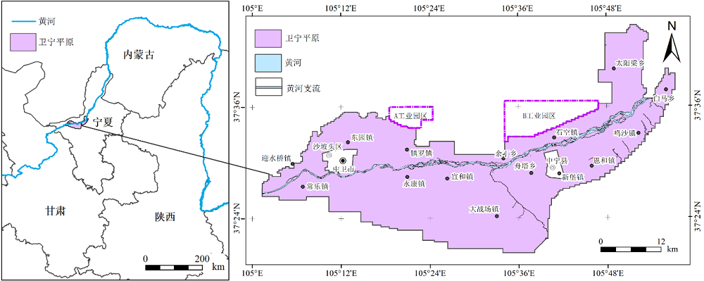
图1 卫宁平原区域位置示意图
Figure 1 Regional location of Weining Plain
| 元素 Elements/(mg·kg-1) | pH | ||||||||||||
|---|---|---|---|---|---|---|---|---|---|---|---|---|---|
| As | Hg | Cr | Ni | Cd | Cu | Pb | Zn | Al | Li | Sc | Ti | ||
| 检测方法 Detection Method | AFS | ICP-OES | ICP-MS | XRF | ICP-MS | ISE | |||||||
| 检出限 Detection Limits | 0.2 | 0.0005 | 1.5 | 0.2 | 0.02 | 0.1 | 0.02 | 1 | 0.05 | 1 | 1 | 10 | 0.01 |
表1 土壤样品分析项目及其测试方法和检出限
Table 1 Analysis items, method and detection limits of samples
| 元素 Elements/(mg·kg-1) | pH | ||||||||||||
|---|---|---|---|---|---|---|---|---|---|---|---|---|---|
| As | Hg | Cr | Ni | Cd | Cu | Pb | Zn | Al | Li | Sc | Ti | ||
| 检测方法 Detection Method | AFS | ICP-OES | ICP-MS | XRF | ICP-MS | ISE | |||||||
| 检出限 Detection Limits | 0.2 | 0.0005 | 1.5 | 0.2 | 0.02 | 0.1 | 0.02 | 1 | 0.05 | 1 | 1 | 10 | 0.01 |
| 标准因子 Standard factors | 剔除后剩余样本量 Sample size after elimination | 最大值 Max/(mg·kg-1) | 最小值 Min/(mg·kg-1) | 平均值 Ave/(mg·kg-1) | 标准差 Standard deviation | 变异系数 Coefficients of variation |
|---|---|---|---|---|---|---|
| Al | 2628 | 13.18 | 7.40 | 10.91 | 1.27 | 0.12 |
| Li | 2659 | 45.23 | 16.83 | 31.80 | 4.77 | 0.15 |
| Ti | 2741 | 3700.20 | 1803.90 | 3171.73 | 354.52 | 0.11 |
| Sc | 2711 | 13.07 | 4.79 | 9.73 | 1.59 | 0.16 |
表2 土壤稳定元素含量统计特征
Table 2 Statistical results of stable elements contents in the soils of the research region
| 标准因子 Standard factors | 剔除后剩余样本量 Sample size after elimination | 最大值 Max/(mg·kg-1) | 最小值 Min/(mg·kg-1) | 平均值 Ave/(mg·kg-1) | 标准差 Standard deviation | 变异系数 Coefficients of variation |
|---|---|---|---|---|---|---|
| Al | 2628 | 13.18 | 7.40 | 10.91 | 1.27 | 0.12 |
| Li | 2659 | 45.23 | 16.83 | 31.80 | 4.77 | 0.15 |
| Ti | 2741 | 3700.20 | 1803.90 | 3171.73 | 354.52 | 0.11 |
| Sc | 2711 | 13.07 | 4.79 | 9.73 | 1.59 | 0.16 |
| 元素 Elements | As | Cd | Cr | Hg | Ni | Cu | Pb | Zn |
|---|---|---|---|---|---|---|---|---|
| Al | 0.77 | 0.80 | 0.58 | 0.78 | 0.87 | 0.90 | 0.88 | 0.92 |
| Li | 0.63 | 0.59 | 0.35 | 0.54 | 0.58 | 0.69 | 0.64 | 0.69 |
| Sc | 0.58 | 0.52 | 0.38 | 0.47 | 0.54 | 0.63 | 0.57 | 0.61 |
| Ti | 0.59 | 0.52 | 0.40 | 0.46 | 0.55 | 0.65 | 0.56 | 0.64 |
表3 土壤重金属与Al、Li、Sc、Ti相关系数表
Table 3 Correlation coefficients between heavy metal elements and Al, Li, Sc, Ti
| 元素 Elements | As | Cd | Cr | Hg | Ni | Cu | Pb | Zn |
|---|---|---|---|---|---|---|---|---|
| Al | 0.77 | 0.80 | 0.58 | 0.78 | 0.87 | 0.90 | 0.88 | 0.92 |
| Li | 0.63 | 0.59 | 0.35 | 0.54 | 0.58 | 0.69 | 0.64 | 0.69 |
| Sc | 0.58 | 0.52 | 0.38 | 0.47 | 0.54 | 0.63 | 0.57 | 0.61 |
| Ti | 0.59 | 0.52 | 0.40 | 0.46 | 0.55 | 0.65 | 0.56 | 0.64 |
| 重金属 Heavy metals | 标准因子 Standard Factor | 基线方程 Baseline equation | R2 | 基线值 Baseline values/ (mg·kg-1) |
|---|---|---|---|---|
| As | Al | a=b×1.79-7.52 | 0.734 | 14.51 |
| Cd | a=b×0.05-0.35 | 0.688 | 0.29 | |
| Cr | a=b×3.4-29.16 | 0.497 | 79.61 | |
| Hg | a=b×0.01-0.08 | 0.588 | 0.05 | |
| Ni | a=b×3.0-3.9 | 0.762 | 34.57 | |
| Cu | a=b×3.5-16.2 | 0.864 | 26.42 | |
| Pb | a=b×2.4-6.2 | 0.816 | 23.95 | |
| Zn | a=b×10.5-53.4 | 0.866 | 73.49 |
表4 土壤重金属环境地球化学基线值
Table 4 The environmental geochemical baseline values of the heavy metal in the soils
| 重金属 Heavy metals | 标准因子 Standard Factor | 基线方程 Baseline equation | R2 | 基线值 Baseline values/ (mg·kg-1) |
|---|---|---|---|---|
| As | Al | a=b×1.79-7.52 | 0.734 | 14.51 |
| Cd | a=b×0.05-0.35 | 0.688 | 0.29 | |
| Cr | a=b×3.4-29.16 | 0.497 | 79.61 | |
| Hg | a=b×0.01-0.08 | 0.588 | 0.05 | |
| Ni | a=b×3.0-3.9 | 0.762 | 34.57 | |
| Cu | a=b×3.5-16.2 | 0.864 | 26.42 | |
| Pb | a=b×2.4-6.2 | 0.816 | 23.95 | |
| Zn | a=b×10.5-53.4 | 0.866 | 73.49 |
| 重金属 Elements | ||||||||
|---|---|---|---|---|---|---|---|---|
| As | Cd | Cr | Hg | Ni | Cu | Pb | Zn | |
| 范围 Range | 3.89-26.6 | 0.01-0.87 | 31.00-104.0 | 0.01-0.36 | 3.55-89.7 | 9.08-52.2 | 11.70-72.7 | 25.10-307.0 |
| 平均值 Ave | 12.19±2.62 | 0.19±0.08 | 66.95±6.47 | 0.03±0.03 | 28.61±4.79 | 21.82±4.91 | 20.44±3.84 | 61.78±16.03 |
| 变异系数 Coefficients of variation | 0.22 | 0.54 | 0.10 | 0.69 | 0.17 | 0.22 | 0.19 | 0.26 |
| 风险筛查值 Risk screening values | 20 | 0.8 | 250 | 1 | 190 | 100 | 170 | 300 |
| 黄河流域背景值 Background values of Yellow River Basin | 10.9 | 0.113 | 65 | 0.017 | 28 | 21 | 20 | 59 |
表5 土壤重金属含量统计表
Table 5 Statistical results of heavy metal content in soils mg·kg-1
| 重金属 Elements | ||||||||
|---|---|---|---|---|---|---|---|---|
| As | Cd | Cr | Hg | Ni | Cu | Pb | Zn | |
| 范围 Range | 3.89-26.6 | 0.01-0.87 | 31.00-104.0 | 0.01-0.36 | 3.55-89.7 | 9.08-52.2 | 11.70-72.7 | 25.10-307.0 |
| 平均值 Ave | 12.19±2.62 | 0.19±0.08 | 66.95±6.47 | 0.03±0.03 | 28.61±4.79 | 21.82±4.91 | 20.44±3.84 | 61.78±16.03 |
| 变异系数 Coefficients of variation | 0.22 | 0.54 | 0.10 | 0.69 | 0.17 | 0.22 | 0.19 | 0.26 |
| 风险筛查值 Risk screening values | 20 | 0.8 | 250 | 1 | 190 | 100 | 170 | 300 |
| 黄河流域背景值 Background values of Yellow River Basin | 10.9 | 0.113 | 65 | 0.017 | 28 | 21 | 20 | 59 |
| 元素 Elements | |||||||||
|---|---|---|---|---|---|---|---|---|---|
| As | Cd | Cr | Hg | Ni | Cu | Pb | Zn | ||
| 无污染 Clean | 7.77 | 31.41 | 1.45 | 29.36 | 3.78 | 9.12 | 0.99 | 10.67 | 10.85 |
| 轻微污染 Non-contamination | 52.93 | 18.59 | 59.36 | 17.84 | 49.40 | 43.75 | 52.05 | 48.69 | 39.82 |
| 轻度污染 Slight contamination | 39.30 | 48.20 | 39.19 | 44.49 | 46.71 | 47.03 | 46.78 | 40.39 | 46.01 |
| 中度污染 Moderate contamination | - | 1.45 | - | 6.47 | 0.11 | 0.11 | 0.11 | 0.14 | 3.32 |
| 重度污染 Heavy contamination | - | 0.35 | - | 1.84 | - | - | 0.07 | 0.11 | - |
表6 不同污染等级样点数百分比
Table 6 Percentage of sample points of different contamination levels %
| 元素 Elements | |||||||||
|---|---|---|---|---|---|---|---|---|---|
| As | Cd | Cr | Hg | Ni | Cu | Pb | Zn | ||
| 无污染 Clean | 7.77 | 31.41 | 1.45 | 29.36 | 3.78 | 9.12 | 0.99 | 10.67 | 10.85 |
| 轻微污染 Non-contamination | 52.93 | 18.59 | 59.36 | 17.84 | 49.40 | 43.75 | 52.05 | 48.69 | 39.82 |
| 轻度污染 Slight contamination | 39.30 | 48.20 | 39.19 | 44.49 | 46.71 | 47.03 | 46.78 | 40.39 | 46.01 |
| 中度污染 Moderate contamination | - | 1.45 | - | 6.47 | 0.11 | 0.11 | 0.11 | 0.14 | 3.32 |
| 重度污染 Heavy contamination | - | 0.35 | - | 1.84 | - | - | 0.07 | 0.11 | - |

图2 土壤重金属单指标潜在生态危害风险
Figure 2 Potential ecological risk of individual heavy metal in soils
| 等级 Level | Cd | Hg | |||
|---|---|---|---|---|---|
| n | Percentage | n | Percentage | ||
| 中等风险 Moderate Risk | 1264 | 44.66 | 1191 | 42.08 | |
| 较强风险 Considerable Risk | 41 | 1.45 | 193 | 6.82 | |
| 强风险 High Risk | 1 | 0.04 | 16 | 0.57 | |
| 极强风险 Very High Risk | 0 | 0.00 | 5 | 0.18 | |
表7 土壤Cd、Hg潜在生态风险等级
Table 7 Potential ecological risk of Cd and Hg in soils
| 等级 Level | Cd | Hg | |||
|---|---|---|---|---|---|
| n | Percentage | n | Percentage | ||
| 中等风险 Moderate Risk | 1264 | 44.66 | 1191 | 42.08 | |
| 较强风险 Considerable Risk | 41 | 1.45 | 193 | 6.82 | |
| 强风险 High Risk | 1 | 0.04 | 16 | 0.57 | |
| 极强风险 Very High Risk | 0 | 0.00 | 5 | 0.18 | |
| 重金属 Heavy metals | ||||||||
|---|---|---|---|---|---|---|---|---|
| As | Cd | Cr | Hg | Ni | Cu | Pb | Zn | |
| 平均值 Ave | 1.01 | 0.97 | 1.02 | 1.12 | 1 | 0.99 | 1.03 | 1 |
| 范围 Range | 0.42- 3.67 | 0.09- 4.91 | 0.6- 1.77 | 0.14- 11.07 | 0.12- 3.17 | 0.52- 2.09 | 0.71- 3.75 | 0.54- 4.18 |
| E>2/% | 0.81 | 5.41 | 0.14 | 18.94 | 0.39 | 0.64 | 0.46 | 0.57 |
表8 重金属富集因子评价结果
Table 8 The enrichment factors evaluation results of heavy metal
| 重金属 Heavy metals | ||||||||
|---|---|---|---|---|---|---|---|---|
| As | Cd | Cr | Hg | Ni | Cu | Pb | Zn | |
| 平均值 Ave | 1.01 | 0.97 | 1.02 | 1.12 | 1 | 0.99 | 1.03 | 1 |
| 范围 Range | 0.42- 3.67 | 0.09- 4.91 | 0.6- 1.77 | 0.14- 11.07 | 0.12- 3.17 | 0.52- 2.09 | 0.71- 3.75 | 0.54- 4.18 |
| E>2/% | 0.81 | 5.41 | 0.14 | 18.94 | 0.39 | 0.64 | 0.46 | 0.57 |

图3 土壤重金属污染风险分区
Figure 3 The risk zone subarea of heavy metals contamination in soils
| [1] |
ABRAHAM J, 1998. Spatial distribution of major and trace elements in shallow reservoir sediments: an example from Lake Waco, Texas[J]. Environmental Geology, 36(3): 349-363.
DOI URL |
| [2] |
DONOGHUE J F, RAGLAND P C, CHEN Z Q, et al., 1998. Standardization of metal concentrations in sediments using regression residuals: an example from a large lake in Florida, USA[J]. Environmental Geology, 36(1): 65-76.
DOI URL |
| [3] | NEWMAN, B K, WATLING, R J, 2007. Definition of baseline metal concentrations for assessing metal enrichment of sediment from the south-eastern Cape coastline of South Africa[J]. Water SA, 33(5): 675-692. |
| [4] |
SURESH G, SUTHARSAN P, RAMASAMY V, et al., 2012. Assessment of spatial distribution and potential ecological risk of the heavy metals in relation to granulometric contents of veeranam lake sediments, India[J]. Ecotoxicology and Environmental Safety, 84: 117-124.
DOI PMID |
| [5] |
N'GUESSAN Y M, PROBST J L, BUR T, et al., 2008. Trace elements in stream bed sediments from agricultural catchments (Gascogne region, S-W France): Where do they come from[J]. Science of the Total Environment, 407(8): 2939-2952.
DOI URL |
| [6] | 胡杰, 赵心语, 王婷婷, 等, 2022. 太原市汾河河岸带土壤重金属分布特征、评价与来源解析[J]. 环境科学, 43(5): 2500-2509. |
| HU J, ZHAO X Y, WANG T T, et al., 2022. Distribution characteristic, evaluation, and source analysis of heavy metals in soils of Fenhe Riparian Zone in Taiyuan city[J]. Environmental Science, 43(5): 2500-2509. | |
| [7] | 纪小凤, 郑娜, 王洋, 等, 2016. 中国城市土壤重金属污染研究现状及展望[J]. 土壤与作物, 5(1): 42-47. |
| JI X F, ZHENG N, WANG Y, et al., 2016. Heavy metal contamination of urban soils in China: recent advances and prospects[J]. Soils and Crops, 5(1): 42-47. | |
| [8] | 李梦婷, 沈城, 吴健, 等, 2021. 快速城市化区域不同用地类型土壤重金属含量分布特征及生态风险[J]. 环境科学, 42(10): 4889-4896. |
|
LI M T, SHEN C, WU J, et al., 2021. Content and ecological risks of heavy metals in soil with different land uses in a rapidly urbanizing area[J]. Environmental Science, 42(10): 4889-4896.
DOI URL |
|
| [9] | 李伟迪, 崔云霞, 曾撑撑, 等, 2019. 太滆运河流域农田土壤重金属污染特征与来源解析[J]. 环境科学, 40(11): 5073-5081. |
| LI W D, CUI Y X, ZENG C C, et al., 2019. Pollution characteristics and source analysis of heavy metals in farmland soils in the Taige Canal Valley[J]. Environmental Science, 40(11): 5073-5081. | |
| [10] | 李一蒙, 马建华, 刘德新, 等, 2015. 开封城市土壤重金属污染及潜在生态风险评价[J]. 环境科学, 36(3): 1037-1044. |
| LI Y M, MA J H, LIU D X, et al., 2015. Assessment of heavy metal pollution and potential ecological risks of urban soils in Kaifeng City, China[J]. Environmental Science, 36(3): 1037-1044. | |
| [11] | 刘爱华, 2005. 土壤环境中As、Cd、Hg、Pb地球化学背景及通量研究[D]. 北京: 中国地质大学 (北京): 2-3. |
| LIU A H, 2005. Research on geochemical background and flux for arsenic, cadmium, mercury and lead in soil environment[D]. Beijing: China University of Geosciences (Beijing): 2-3. | |
| [12] | 刘娣, 苏超, 张红, 等, 2022. 典型煤炭产业聚集区土壤重金属污染特征与风险评价[J]. 生态环境学报, 31(2): 391-399. |
| LIU D, SU C, ZHANG H, et al., 2022. Pollution characteristics and risk assessment of heavy metal pollution in a typical coal-based industrial cluster zone[J]. Ecology and Environmental Sciences, 31(2): 391-399. | |
| [13] | 刘雪松, 王雨山, 尹德超, 等, 2022. 白洋淀内不同土地利用类型土壤重金属分布特征与污染评价[J]. 土壤通报, 53(3): 710-717. |
| LIU X S, WANG Y S, YIN D C, et al., 2022. Characteristics and assessment of soil heavy metal pollution under different land-use types in the Baiyangdian Wetland[J]. Chinese Journal of Soil Science, 53(3): 710-717. | |
| [14] | 马建华, 朱玉涛, 2008. 嵩山景区旅游活动对土壤组成性质和重金属污染的影响[J]. 生态学报, 28(3): 955-965. |
| MA J H, ZHU Y T, 2008. Impacts of tourist activities on components, properties and heavy metal pollution of soils in the Songshan scenic area[J]. Acta Ecologica Sinica, 28(3): 955-965. | |
| [15] | 沈仁芳, 颜晓元, 张甘霖, 等, 2020. 新时期中国土壤科学发展现状与战略思考[J]. 土壤学报, 57(5): 1051-1059. |
| SHEN R F, YAN X Y, ZHANG G L, et al., 2020. Status quo of and strategic thinking for the development of soil science in China in the new era[J]. Acta Pedologica Sinica, 57(5): 1051-1059. | |
| [16] | 史正军, 吴冲, 卢瑛, 2007. 深圳市主要公园及道路绿地土壤重金属含量状况比较研究[J]. 土壤通报, 38(1): 133-136. |
| SHI Z J, WU C, LU Y, 2007. Comparative study on soil heavy metal content of urban green ground near parks and roads in Shenzhen city[J]. Chinese Journal of Soil Science, 38(1): 133-136. | |
| [17] | 孙帅, 耿柠波, 郭崔崔, 等, 2021. 我国东部沿海地区蔬菜中重金属累积分布特征及居民膳食暴露评估[J]. 环境科学, 42(11): 5519-5525. |
| SUN S, GENG N B, GUO C C, et al., 2021. Accumulation characteristics and dietary exposure estimation of heavy metals in vegetables from the eastern coastal region of China[J]. Environmental Science, 42(11): 5519-5525. | |
| [18] | 滕彦国, 倪师军, 张成江, 2001. 环境地球化学基线研究简介[J]. 物探化探计算技术, 23(2): 135-139. |
| TENG Y G, NI S J, ZHANG C J, 2001. Introduction to the study of environmental geochemical baseline[J]. Geophysical and Geochemical Exploration, 23(2): 135-139. | |
| [19] | 滕彦国, 庹先国, 倪师军, 等, 2003. 地球化学基线的确定方法研究—以攀枝花地区为例[J]. 成都理工大学学报 (自然科学版), 30(4): 422-428. |
| TENG Y G, TUO X G, NI S J, et al., 2003. Approach of determining geochemical baselines: A study case from Panzhihua region[J]. Journal of Chengdu University of Technology (Science &Technology Edition), 30(4): 422-428. | |
| [20] | 滕彦国, 2001. 攀枝花地区土壤环境地球化学基线研究[D]. 成都: 成都理工大学: 26-32. |
| TENG Y G, 2001. Study of environmental geochemical baseline in Panzhihua region[D]. Chengdu: Chengdu University of Technology: 26-32. | |
| [21] | 王成, 程建华, 孟方, 等, 2017. 中国区域地质志·宁夏志[M]. 北京: 地质出版社: 770-839. |
| WANF C, CHENG J H, MENG F, et al., 2017. Regional geology of China-Ningxia annals[M]. Beijing: Geological Publishing House: 770-839. | |
| [22] | 王乔林, 宋云涛, 王成文, 等, 2021. 滇西地区土壤重金属来源解析及空间分布[J]. 中国环境科学, 41(8): 3693-3703. |
| WANG Q L, SONG Y T, WANG C W, et al., 2021. Source identification and spatial distribution of soil heavy metals in Western Yunnan[J]. China Environmental Science, 41(8): 3693-3703. | |
| [23] | 奚小环, 侯青叶, 杨忠芳, 等, 2021. 基于大数据的中国土壤背景值与基准值及其变化特征研究-写在《中国土壤地球化学参数》出版之际[J]. 物探与化探, 45(5): 1095-1108. |
| XI X H, HOU Q Y, YANG Z F, et al., 2021. Big data based studies of the variation features of Chinese soil’s background value versus reference value: A paper written on the occasion of Soil Geochemical Parameters of China’s publication[J]. Geophysical & Geochemical Exploration, 45(5): 1095-1108. | |
| [24] | 杨湜烟, 刘杏梅, 徐建明, 2022. 土壤重金属污染健康风险评估新视角—概率风险评估的源起及展望[J]. 土壤学报, 59(1): 28-37. |
| YANG S Y, LIU X M, XU J M, 2022. New perspectives about health risk assessment of soil heavy metal pollution-origin and prospects of probabilistic risk analysis[J]. Acta Pedologica Sinica, 59(1): 28-37. | |
| [25] | 曾伟斌, 顾高铨, 万小铭, 等, 2021. 多功能区工业园土壤和地表灰尘重金属污染及生态风险差异分析[J]. 环境科学, 42(3): 1105-1113. |
| ZENG W B, GU G Q, WAN X M, et al., 2021. Heavy metal contents of soil and surface dust and its ecological risk analysis in a multifunctional industrial park[J]. Environmental Science, 42(3): 1105-1113. | |
| [26] | 张江周, 李奕赞, 李颖, 等, 2022. 土壤健康指标体系与评价方法研究进展[J]. 土壤学报, 59(3): 603-616. |
| ZHANG J Z, LI Y Z, LI Y, et al., 2022. Advances in the indicator system and evaluation approaches of soil health[J]. Acta Pedologica Sinica, 59(3): 603-616. | |
| [27] | 张磊, 宋凤斌, 王晓波, 2004. 中国城市土壤重金属污染研究现状及对策[J]. 生态环境, 13(2): 258-260. |
| ZHANG L, SONG F B, WANG X B, 2004. Heavy metal contamination of urban soils in China: Status and countermeasures[J]. Ecology and Environment, 13(02):258-260. | |
| [28] | 张利, 2020. 云南省保山地区土壤和水系沉积物地球化学特征与驱动因素研究[D]. 北京: 中国地质大学 (北京): 90-91. |
| ZHNAG L, 2020. A dissertation submitted to China university of geosciences for doctorate degree[D]. Beijing: China University of Geosciences (Beijing): 90-91. | |
| [29] | 张秀芝, 鲍征宇, 唐俊红, 2006. 富集因子在环境地球化学重金属污染评价中的应用[J]. 地质科技情报, 25(1): 65-72. |
| ZHANG X Z, BAO Z Y, TANG J H, 2006. Application of the enrichment factor in evaluating of heavy metals contamination in the environmental geochemistry[J]. Geological Science and Technology Information, 25(1): 65-72. | |
| [30] | 张秀芝, 杨志宏, 马忠社, 等, 2006. 地球化学背景与地球化学基准[J]. 地质通报, 25(5): 626-629. |
| ZHANG X Z, YANG Z H, MA Z S, et al., 2006. Geochemical background and geochemical baseline[J]. Geological Bulletin of China, 25(5): 626-629. | |
| [31] | 张云芸, 马瑾, 魏海英, 等, 2019. 浙江省典型农田土壤重金属污染及生态风险评价[J]. 生态环境学报, 28(6): 1233-1241. |
| ZHANG Y Y, MA J, WEI H Y, et al., 2019. Heavy metals in typical farmland soils of Zhejiang province: levels, sources and ecological risks[J]. Ecology and Environmental Sciences, 28(6): 1233-1241. | |
| [32] | 章海波, 骆永明, 2010. 区域尺度土壤环境地球化学基线估算方法及其应用研究[J]. 环境科学, 31(7): 1607-1613. |
|
ZHANG H B, LUO Y M, et al., 2010. Researches on the estimate methods and applications of soil environmental geochemical baseline at a regional scale[J]. Environmental Science, 31(7): 1607-1613.
DOI URL |
|
| [33] | 中华人民共和国国土资源部, 2014. 多目标区域地球化学调查规范(1:250000): DZ/T 0258-2014[S]. 北京: 中国标准出版社: 3-20. |
| Ministry of Land and Resources of the People’s Republic of China, 2014. Specification of Multi-Purpose Regional Geochemical Survey:DZ/T 0258-2015[S] Beijing: Geological Publishing House: 3-20. | |
| [34] | 中华人民共和国国土资源部, 2016. 土地质量地球化学评价规范: DZ/T0295-2016[S]. 北京: 地质出版社: 5-6. |
| Ministry of Land and Resources of the People’s Republic of China, 2016. Specification of land quality geochemical assessment:DZ/T 0295-2016[S] Beijing: Geological Publishing House: 5-6. | |
| [35] | 中华人民共和国生态环境部, 2018. 土壤环境质量农用地土壤污染风险管控标准 (试行): GB 15618-2018[S]. 北京: 中国标准出版社: 2-3. |
| Ministry of Ecological Environment of the People’ Republic of China, 2018. Soil environmental quality Risk control standard for soil contamination of agricultural land (Trial): GB 15618-2018[S]. Beijing: China Environmental Science Press: 2-3. | |
| [36] | 周亚龙, 杨志斌, 王乔林, 等, 2021. 雄安新区农田土壤-农作物系统重金属潜在生态风险评估及其源解析[J]. 环境科学, 42(4): 2003-2015. |
| ZHOU Y L, YANG Z B, WANG Q L, et al., 2021. Potential ecological risk assessment and sourceanalysis of heavy metals in soil-crop system in Xiong’an New District[J] Environmental Science, 42(4): 2003-2015. |
| [1] | 杜丹丹, 高瑞忠, 房丽晶, 谢龙梅. 旱区盐湖盆地土壤重金属空间变异及对土壤理化因子的响应[J]. 生态环境学报, 2023, 32(6): 1123-1132. |
| [2] | 李传福, 朱桃川, 明玉飞, 杨宇轩, 高舒, 董智, 李永强, 焦树英. 有机肥与脱硫石膏对黄河三角洲盐碱地土壤团聚体及其有机碳组分的影响[J]. 生态环境学报, 2023, 32(5): 878-888. |
| [3] | 陈俊芳, 吴宪, 刘啸林, 刘娟, 杨佳绒, 刘宇. 不同土壤水分下元素化学计量对微生物多样性的塑造特征[J]. 生态环境学报, 2023, 32(5): 898-909. |
| [4] | 董智今, 张呈春, 展秀丽, 张维福. 宁夏河东沙地生物土壤结皮及其下伏土壤养分的空间分布特征[J]. 生态环境学报, 2023, 32(5): 910-919. |
| [5] | 周沁苑, 董全民, 王芳草, 刘玉祯, 冯斌, 杨晓霞, 俞旸, 张春平, 曹铨, 刘文亭. 放牧方式对高寒草地瑞香狼毒根际土壤团聚体及有机碳特征的影响[J]. 生态环境学报, 2023, 32(4): 660-667. |
| [6] | 潘昱伶, 璩向宁, 李琴, 王磊, 王筱平, 谭鹏, 崔庚, 安雨, 佟守正. 黄河宁夏段典型滩涂湿地土壤理化因子空间分布特征及其对微地形的响应[J]. 生态环境学报, 2023, 32(4): 668-677. |
| [7] | 赵维彬, 唐丽, 王松, 刘玲玲, 王树凤, 肖江, 陈光才. 两种生物炭对滨海盐碱土的改良效果[J]. 生态环境学报, 2023, 32(4): 678-686. |
| [8] | 冯树娜, 吕家珑, 何海龙. KI淋洗对黄绵土汞污染的去除效果及土壤理化性状的影响[J]. 生态环境学报, 2023, 32(4): 776-783. |
| [9] | 陈敏毅, 朱航海, 佘伟铎, 尹光彩, 黄祖照, 杨巧玲. 珠三角某遗留造船厂场地土壤重金属人体健康风险评估及源解析[J]. 生态环境学报, 2023, 32(4): 794-804. |
| [10] | 张林, 齐实, 周飘, 伍冰晨, 张岱, 张岩. 北京山区针阔混交林地土壤有机碳含量的影响因素研究[J]. 生态环境学报, 2023, 32(3): 450-458. |
| [11] | 秦浩, 李蒙爱, 高劲, 陈凯龙, 张殷波, 张峰. 芦芽山不同海拔灌丛土壤细菌群落组成和多样性研究[J]. 生态环境学报, 2023, 32(3): 459-468. |
| [12] | 唐海明, 石丽红, 文丽, 程凯凯, 李超, 龙泽东, 肖志武, 李微艳, 郭勇. 长期施肥对双季稻田根际土壤氮素的影响[J]. 生态环境学报, 2023, 32(3): 492-499. |
| [13] | 刘抗旱, 郑刘根, 张理群, 丁丹, 单士锋. 复合型植物源活化剂强化蜈蚣草修复砷污染土壤的效应研究[J]. 生态环境学报, 2023, 32(3): 635-642. |
| [14] | 樊慧琳, 张佳敏, 李欢, 王艳玲. 坡耕地稻田剖面磷的储存格局与流失风险研究[J]. 生态环境学报, 2023, 32(2): 283-291. |
| [15] | 宋孝帅, 丁武泉, 刘新敏, 李廷真. 离子特异性效应对紫色土孔隙状况的影响机制研究[J]. 生态环境学报, 2023, 32(2): 292-298. |
| 阅读次数 | ||||||
|
全文 |
|
|||||
|
摘要 |
|
|||||