生态环境学报 ›› 2021, Vol. 30 ›› Issue (7): 1470-1481.DOI: 10.16258/j.cnki.1674-5906.2021.07.016
胡琳1,2( ), 李思悦2,3,*()
收稿日期:2021-01-25
出版日期:2021-07-18
发布日期:2021-10-09
通讯作者:
*李思悦,教授,博士研究生导师,主要研究领域为河-库地球化学过程与环境效应、内陆水体温室气体释放与碳中和,流域水环境与污染源解析。E-mail: syli2006@163.com作者简介:胡琳(1997年生),男,硕士研究生,主要研究方向为河流水环境与土地利用。E-mail: 634944710@qq.com
基金资助:
HU Lin1,2(), LI Siyue2,3,*()
Received:2021-01-25
Online:2021-07-18
Published:2021-10-09
摘要:
为了探究龙川江流域不同尺度土地利用结构与景观格局对水质的影响,于2017年5和9月对龙川江流域的21个样点进行取样,测定水温、pH、溶解氧饱和度、氮、磷等水质指标。结合2017年10 m分辨率的土地利用数据,提取3种空间尺度(河段、河岸带、子流域)的土地利用结构与景观格局指数,运用相关分析、冗余分析(RDA)、“bioenv”分析和逐步回归模型揭示不同尺度土地利用结构与景观格局对水质的影响。结果表明,龙川江水体主要污染物为TN和TP,水质基本指标有月际性差异,N、P浓度在5月高于9月,但差异不显著。不同空间尺度土地利用结构与水质指标的相关关系不同,子流域尺度土地利用组合与总体水质之间的相关性最强,且林地对水质有正面影响,耕地、建设用地对水质有负面影响。不同尺度的景观格局指数组合与水质的相关性存在差异,河岸带景观格局组合与总体水质的相关性最高,RDA分析表明景观格局指数对总体水质的总解释率为河岸带>子流域>河段。整体上,9月土地利用结构与景观格局对水质的影响要大于5月。多元回归模型发现建设用地和耕地对养分的预测能力及预测指标依赖于空间尺度和取样月份。研究以龙川江为例,证实了土地利用结构与景观格局对水质的影响具有尺度效应,水质响应的空间尺度效应应纳入土地利用规划与水资源管理的过程中,提出长江上游更多的个案研究尤为必要,对长江上游河源区水资源保护及土地利用管理具有重要的意义。
中图分类号:
胡琳, 李思悦. 不同空间尺度土地利用结构与景观格局对龙川江流域水质的影响[J]. 生态环境学报, 2021, 30(7): 1470-1481.
HU Lin, LI Siyue. Scale Effects of Land Use Structure and Landscape Pattern on Water Quality in the Longchuan River Basin[J]. Ecology and Environment, 2021, 30(7): 1470-1481.
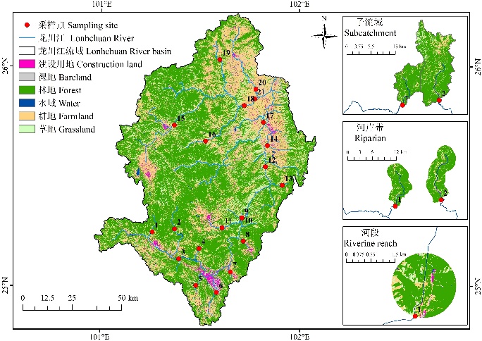
图1 研究区土地利用及采样点分布图 2017年1—12月的降水量分别为43.6、3.1、13.1、51.4、12.4、84.6、128.5、78.9、20.7、13.8、2.2、0 mm
Fig. 1 Study area with land use map and sampling sites Rainfall from Jan. to Dec. in 2017 is 43.6, 3.1, 13.1, 51.4, 12.4, 84.6, 128.5, 78.9, 20.7, 13.8, 2.2, 0 mm, respectively
| 名称 Name | 景观面积 Total landscape area (TA) | 最大斑块指数 Largest patch index (LPI) | 斑块数量 Number of patches (NP) | 斑块密度 Patch density (PD) | 边缘密度 Edge density (ED) | 景观形状指数 Landscape shape index (LSI) |
|---|---|---|---|---|---|---|
| 类型 Type | 面积指标 Area indicator | 面积指标 Area indicator | 密度大小与差异指标 Density size and difference index | 密度大小与差异指标 Density size and difference index | 边缘指标 Edge index | 形状指标 Shape index |
| 名称 Name | 平均形状指数 Mean shape index (SHAPE_MN) | 平均欧式临近距离 Mean euclidean nearest neighbor distance (ENN_MN) | 香农多样性指数 Shannon’s diversity index (SHDI) | 聚合度 Aggregation index (AI) | 整体性 Patch cohesion index (COHESION) | 蔓延度 Contagion (CONTAG) |
| 类型 Type | 形状指标 Shape index | 邻近度指标 Proximity index | 多样性指标 Diversity index | 聚散性指标Convergence and dispersion index | 聚散性指标 Convergence and dispersion index | 聚散性指标 Convergence and dispersion index |
表1 景观指数描述
Table 1 Description of landscape indices
| 名称 Name | 景观面积 Total landscape area (TA) | 最大斑块指数 Largest patch index (LPI) | 斑块数量 Number of patches (NP) | 斑块密度 Patch density (PD) | 边缘密度 Edge density (ED) | 景观形状指数 Landscape shape index (LSI) |
|---|---|---|---|---|---|---|
| 类型 Type | 面积指标 Area indicator | 面积指标 Area indicator | 密度大小与差异指标 Density size and difference index | 密度大小与差异指标 Density size and difference index | 边缘指标 Edge index | 形状指标 Shape index |
| 名称 Name | 平均形状指数 Mean shape index (SHAPE_MN) | 平均欧式临近距离 Mean euclidean nearest neighbor distance (ENN_MN) | 香农多样性指数 Shannon’s diversity index (SHDI) | 聚合度 Aggregation index (AI) | 整体性 Patch cohesion index (COHESION) | 蔓延度 Contagion (CONTAG) |
| 类型 Type | 形状指标 Shape index | 邻近度指标 Proximity index | 多样性指标 Diversity index | 聚散性指标Convergence and dispersion index | 聚散性指标 Convergence and dispersion index | 聚散性指标 Convergence and dispersion index |
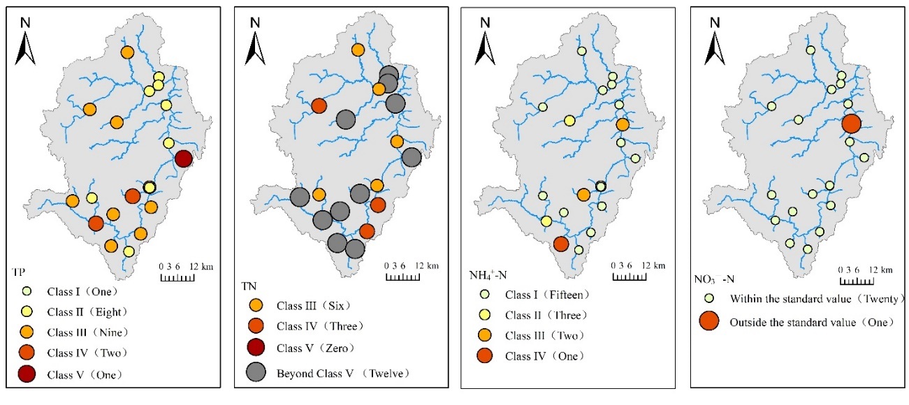
图2 5月水质营养指标空间分布图 括弧中数据代表对应水质标准的样点个数。下同
Fig. 2 Spatial distribution of water quality nutritional indicators in May Number of sampling sites in bracket corresponding to water quality standard. The same below
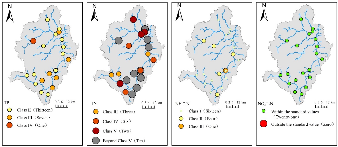
图3 9月水质营养指标空间分布图
Fig. 3 Spatial distribution of water quality nutritional indicators in September
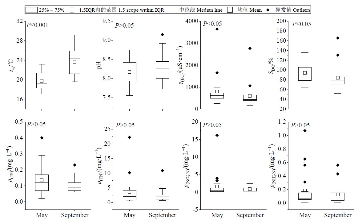
图4 龙川江流域主要水质参数以及时空变化
Fig. 4 Temporal variation of water quality parameters in of the Longchuan River
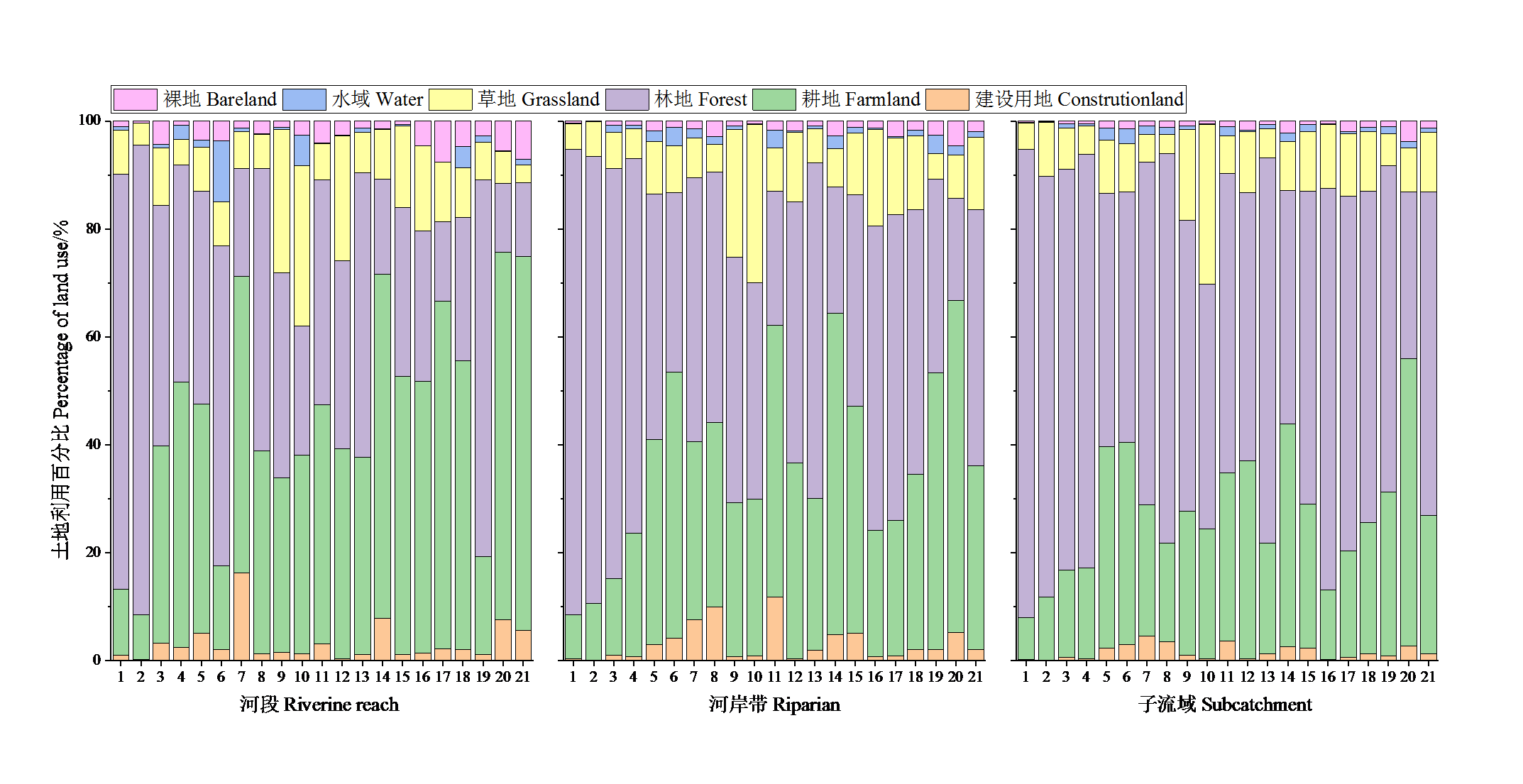
图5 不同尺度土地利用特征
Fig. 5 Land use composition at different spatial scales (riverine reach, riparian and subcatchment)
| 河段 Riverine reach | 耕地 Farmland | 林地 Forest | 草地 Grassland | 水域 Water | 建设用地 Construction land | 裸地 Unused | |||||||||||
|---|---|---|---|---|---|---|---|---|---|---|---|---|---|---|---|---|---|
| 5月 | 9月 | 5月 | 9月 | 5月 | 9月 | 5月 | 9月 | 5月 | 9月 | 5月 | 9月 | ||||||
| tw | 0.125 | 0.319 | -0.061 | -0.343 | -0.495* | 0.172 | 0.339 | -0.012 | 0.266 | -0.177 | 0.353 | 0.424 | |||||
| pH | 0.291 | -0.030 | -0.27 | 0.087 | 0.251 | 0.024 | -0.242 | -0.206 | -0.218 | -0.201 | 0.040 | -0.080 | |||||
| γ(EC) | 0.140 | 0.101 | -0.335 | -0.301 | 0.554** | 0.610** | 0.285 | 0.261 | -0.034 | -0.093 | -0.073 | -0.140 | |||||
| SDO | 0.236 | -0.240 | -0.123 | 0.308 | 0.047 | -0.198 | -0.267 | -0.180 | -0.258 | -0.077 | -0.144 | 0.021 | |||||
| TP | -0.165 | 0.214 | 0.196 | -0.245 | -0.062 | 0.160 | -0.107 | 0.115 | -0.018 | 0.017 | -0.154 | -0.121 | |||||
| TN | 0.401 | 0.445* | -0.316 | -0.413 | -0.173 | -0.150 | -0.201 | -0.026 | 0.272 | 0.571** | 0.121 | -0.105 | |||||
| NO3--N | 0.403 | -0.058 | -0.325 | 0.125 | -0.163 | -0.025 | -0.158 | -0.091 | 0.339 | -0.023 | -0.016 | -0.496* | |||||
| NH4+-N | 0.143 | -0.187 | -0.121 | -0.071 | -0.095 | 0.490* | -0.070 | 0.683** | 0.196 | -0.096 | 0.069 | -0.107 | |||||
表2 河段不同时期水质与土地利用的相关性
Table 2 The correlation between water quality and land use in different period of river reach
| 河段 Riverine reach | 耕地 Farmland | 林地 Forest | 草地 Grassland | 水域 Water | 建设用地 Construction land | 裸地 Unused | |||||||||||
|---|---|---|---|---|---|---|---|---|---|---|---|---|---|---|---|---|---|
| 5月 | 9月 | 5月 | 9月 | 5月 | 9月 | 5月 | 9月 | 5月 | 9月 | 5月 | 9月 | ||||||
| tw | 0.125 | 0.319 | -0.061 | -0.343 | -0.495* | 0.172 | 0.339 | -0.012 | 0.266 | -0.177 | 0.353 | 0.424 | |||||
| pH | 0.291 | -0.030 | -0.27 | 0.087 | 0.251 | 0.024 | -0.242 | -0.206 | -0.218 | -0.201 | 0.040 | -0.080 | |||||
| γ(EC) | 0.140 | 0.101 | -0.335 | -0.301 | 0.554** | 0.610** | 0.285 | 0.261 | -0.034 | -0.093 | -0.073 | -0.140 | |||||
| SDO | 0.236 | -0.240 | -0.123 | 0.308 | 0.047 | -0.198 | -0.267 | -0.180 | -0.258 | -0.077 | -0.144 | 0.021 | |||||
| TP | -0.165 | 0.214 | 0.196 | -0.245 | -0.062 | 0.160 | -0.107 | 0.115 | -0.018 | 0.017 | -0.154 | -0.121 | |||||
| TN | 0.401 | 0.445* | -0.316 | -0.413 | -0.173 | -0.150 | -0.201 | -0.026 | 0.272 | 0.571** | 0.121 | -0.105 | |||||
| NO3--N | 0.403 | -0.058 | -0.325 | 0.125 | -0.163 | -0.025 | -0.158 | -0.091 | 0.339 | -0.023 | -0.016 | -0.496* | |||||
| NH4+-N | 0.143 | -0.187 | -0.121 | -0.071 | -0.095 | 0.490* | -0.070 | 0.683** | 0.196 | -0.096 | 0.069 | -0.107 | |||||
| 河岸带 Riparian | 耕地 Farmland | 林地 Forest | 草地 Grassland | 水域 Water | 建设用地 Construction land | 裸地 Unused | |||||||||||
|---|---|---|---|---|---|---|---|---|---|---|---|---|---|---|---|---|---|
| 5月 | 9月 | 5月 | 9月 | 5月 | 9月 | 5月 | 9月 | 5月 | 9月 | 5月 | 9月 | ||||||
| tw | 0.358 | 0.437* | -0.251 | -0.457* | -0.311 | 0.262 | 0.416 | 0.006 | 0.169 | -0.075 | 0.301 | 0.481* | |||||
| pH | 0.321 | 0.009 | -0.334 | -0.016 | 0.298 | 0.128 | -0.184 | -0.239 | -0.189 | -0.153 | 0.280 | 0.103 | |||||
| γ(EC) | 0.077 | 0.047 | -0.256 | -0.202 | 0.631** | 0.581** | -0.184 | -0.248 | -0.039 | -0.076 | -0.152 | -0.181 | |||||
| SDO | -0.129 | -0.456* | 0.177 | 0.571** | 0.018 | -0.337 | -0.321 | -0.272 | -0.302 | -0.360 | -0.119 | -0.113 | |||||
| TP | -0.194 | 0.048 | 0.188 | -0.176 | -0.166 | 0.275 | 0.056 | -0.082 | 0.231 | 0.327 | -0.313 | -0.204 | |||||
| TN | 0.319 | 0.505* | -0.236 | -0.456* | -0.203 | -0.167 | 0.190 | 0.366 | 0.105 | 0.381 | 0.362 | 0.338 | |||||
| NO3--N | 0.551** | 0.012 | -0.468* | 0.003 | -0.171 | -0.131 | 0.334 | 0.071 | 0.245 | 0.194 | 0.397 | -0.088 | |||||
| NH4+-N | 0.295 | 0.165 | -0.304 | -0.306 | -0.044 | 0.465* | 0.384 | 0.108 | 0.309 | 0.111 | 0.086 | -0.266 | |||||
表3 河岸带不同月份水质与土地利用的相关性
Table 3 The correlation between water quality and land use in different periods of riparian zone
| 河岸带 Riparian | 耕地 Farmland | 林地 Forest | 草地 Grassland | 水域 Water | 建设用地 Construction land | 裸地 Unused | |||||||||||
|---|---|---|---|---|---|---|---|---|---|---|---|---|---|---|---|---|---|
| 5月 | 9月 | 5月 | 9月 | 5月 | 9月 | 5月 | 9月 | 5月 | 9月 | 5月 | 9月 | ||||||
| tw | 0.358 | 0.437* | -0.251 | -0.457* | -0.311 | 0.262 | 0.416 | 0.006 | 0.169 | -0.075 | 0.301 | 0.481* | |||||
| pH | 0.321 | 0.009 | -0.334 | -0.016 | 0.298 | 0.128 | -0.184 | -0.239 | -0.189 | -0.153 | 0.280 | 0.103 | |||||
| γ(EC) | 0.077 | 0.047 | -0.256 | -0.202 | 0.631** | 0.581** | -0.184 | -0.248 | -0.039 | -0.076 | -0.152 | -0.181 | |||||
| SDO | -0.129 | -0.456* | 0.177 | 0.571** | 0.018 | -0.337 | -0.321 | -0.272 | -0.302 | -0.360 | -0.119 | -0.113 | |||||
| TP | -0.194 | 0.048 | 0.188 | -0.176 | -0.166 | 0.275 | 0.056 | -0.082 | 0.231 | 0.327 | -0.313 | -0.204 | |||||
| TN | 0.319 | 0.505* | -0.236 | -0.456* | -0.203 | -0.167 | 0.190 | 0.366 | 0.105 | 0.381 | 0.362 | 0.338 | |||||
| NO3--N | 0.551** | 0.012 | -0.468* | 0.003 | -0.171 | -0.131 | 0.334 | 0.071 | 0.245 | 0.194 | 0.397 | -0.088 | |||||
| NH4+-N | 0.295 | 0.165 | -0.304 | -0.306 | -0.044 | 0.465* | 0.384 | 0.108 | 0.309 | 0.111 | 0.086 | -0.266 | |||||
| 子流域 Subcatchment | 耕地 Farmland | 林地 Forest | 草地 Grassland | 水域 Water | 建设用地 Construction land | 裸地 Unused | |||||||||||
|---|---|---|---|---|---|---|---|---|---|---|---|---|---|---|---|---|---|
| 5月 | 9月 | 5月 | 9月 | 5月 | 9月 | 5月 | 9月 | 5月 | 9月 | 5月 | 9月 | ||||||
| tw | 0.393 | 0.408 | -0.287 | -0.463* | -0.240 | 0.335 | 0.432 | -0.133 | 0.261 | -0.133 | 0.422 | 0.520* | |||||
| pH | 0.366 | -0.011 | -0.395 | -0.051 | 0.287 | 0.190 | -0.185 | -0.186 | -0.170 | -0.117 | 0.339 | 0.111 | |||||
| γ(EC) | 0.052 | 0.068 | -0.326 | -0.314 | 0.775** | 0.740** | -0.148 | -0.231 | -0.075 | -0.140 | -0.078 | -0.085 | |||||
| SDO | -0.082 | -0.298 | 0.118 | 0.399 | -0.012 | -0.278 | -0.264 | -0.324 | -0.323 | -0.362 | -0.072 | -0.051 | |||||
| TP | -0.303 | -0.121 | 0.33 | -0.045 | -0.204 | 0.324 | 0.030 | 0.057 | 0.117 | 0.258 | -0.402 | -0.270 | |||||
| TN | 0.273 | 0.387 | -0.211 | -0.358 | -0.127 | -0.088 | 0.169 | 0.387 | 0.129 | 0.471* | 0.433 | 0.392 | |||||
| NO3--N | 0.472* | -0.128 | -0.407 | 0.165 | -0.087 | -0.163 | 0.302 | -0.032 | 0.279 | 0.106 | 0.474* | -0.145 | |||||
| NH4+-N | 0.317 | 0.146 | -0.313 | -0.364 | 0.004 | 0.591** | 0.512* | 0.185 | 0.317 | 0.128 | 0.073 | -0.105 | |||||
表4 子流域不同时期水质与土地利用与土地覆盖的相关性
Table 4 The correlation between water quality and land use and land cover in different periods of sub-watershed
| 子流域 Subcatchment | 耕地 Farmland | 林地 Forest | 草地 Grassland | 水域 Water | 建设用地 Construction land | 裸地 Unused | |||||||||||
|---|---|---|---|---|---|---|---|---|---|---|---|---|---|---|---|---|---|
| 5月 | 9月 | 5月 | 9月 | 5月 | 9月 | 5月 | 9月 | 5月 | 9月 | 5月 | 9月 | ||||||
| tw | 0.393 | 0.408 | -0.287 | -0.463* | -0.240 | 0.335 | 0.432 | -0.133 | 0.261 | -0.133 | 0.422 | 0.520* | |||||
| pH | 0.366 | -0.011 | -0.395 | -0.051 | 0.287 | 0.190 | -0.185 | -0.186 | -0.170 | -0.117 | 0.339 | 0.111 | |||||
| γ(EC) | 0.052 | 0.068 | -0.326 | -0.314 | 0.775** | 0.740** | -0.148 | -0.231 | -0.075 | -0.140 | -0.078 | -0.085 | |||||
| SDO | -0.082 | -0.298 | 0.118 | 0.399 | -0.012 | -0.278 | -0.264 | -0.324 | -0.323 | -0.362 | -0.072 | -0.051 | |||||
| TP | -0.303 | -0.121 | 0.33 | -0.045 | -0.204 | 0.324 | 0.030 | 0.057 | 0.117 | 0.258 | -0.402 | -0.270 | |||||
| TN | 0.273 | 0.387 | -0.211 | -0.358 | -0.127 | -0.088 | 0.169 | 0.387 | 0.129 | 0.471* | 0.433 | 0.392 | |||||
| NO3--N | 0.472* | -0.128 | -0.407 | 0.165 | -0.087 | -0.163 | 0.302 | -0.032 | 0.279 | 0.106 | 0.474* | -0.145 | |||||
| NH4+-N | 0.317 | 0.146 | -0.313 | -0.364 | 0.004 | 0.591** | 0.512* | 0.185 | 0.317 | 0.128 | 0.073 | -0.105 | |||||
| 参数 Parameter | 河段 Riverine reach | R2 | 河岸带 Riparian | R2 | 子流域 Subcatchment | R2 | |
|---|---|---|---|---|---|---|---|
| 5月 | TP | * | * | * | |||
| TN | * | * | * | ||||
| NO3--N | * | 13.08耕地-2.78 13.08 Farmland -2.78 | 0.300 | 15耕地-2.222 15 Farmland -2.222 | 0.230 | ||
| NH4+-N | * | * | * | ||||
| 9月 | TP | * | * | * | |||
| TN | 27.65建设用地+2.54耕地+0.32 27.65 Construction land+2.54 Farmland+0.32 | 0.360 | 7.52耕地-0.262 7.52 Farmland -0.262 | 0.260 | 77.44建设用地+1.04 77.44 Construction land +1.04 | 0.220 | |
| NO3--N | 1.381—17.183裸地 1.381‒17.183 Unused | 0.250 | * | * | |||
| NH4+-N | 3.22水域+0.79草地-0.01 3.22 Water +0.79 Grassland -0.01 | 0.650 | 0.98草地+0.02 0.98 Grassland +0.02 | 0.220 | 1.45草地-0.02 1.45 Grassland -0.02 | 0.350 |
表5 土地利用与水质营养指标回归关系模型
Table 5 Regression models between land use and water quality
| 参数 Parameter | 河段 Riverine reach | R2 | 河岸带 Riparian | R2 | 子流域 Subcatchment | R2 | |
|---|---|---|---|---|---|---|---|
| 5月 | TP | * | * | * | |||
| TN | * | * | * | ||||
| NO3--N | * | 13.08耕地-2.78 13.08 Farmland -2.78 | 0.300 | 15耕地-2.222 15 Farmland -2.222 | 0.230 | ||
| NH4+-N | * | * | * | ||||
| 9月 | TP | * | * | * | |||
| TN | 27.65建设用地+2.54耕地+0.32 27.65 Construction land+2.54 Farmland+0.32 | 0.360 | 7.52耕地-0.262 7.52 Farmland -0.262 | 0.260 | 77.44建设用地+1.04 77.44 Construction land +1.04 | 0.220 | |
| NO3--N | 1.381—17.183裸地 1.381‒17.183 Unused | 0.250 | * | * | |||
| NH4+-N | 3.22水域+0.79草地-0.01 3.22 Water +0.79 Grassland -0.01 | 0.650 | 0.98草地+0.02 0.98 Grassland +0.02 | 0.220 | 1.45草地-0.02 1.45 Grassland -0.02 | 0.350 |
| 月份 Month | TA | LPI | NP | PD | ED | LSI | SHAPE_MN | ENN_MN | SHDI | AI | COHESION | CONTAG | 总计 Total | |
|---|---|---|---|---|---|---|---|---|---|---|---|---|---|---|
| 河段 Riverine reach | 5月 May | 0.4 | 9.6 | 8.4 | 0.0 | 0.0 | <0.1 | 17.6** | 1.2 | 0.1 | 9.3 | 19.8* | 0.3 | 66.7 |
| 9月 September | 0.2 | 6 | 13.1* | 0.0 | 0.0 | <0.1 | 9.1 | 1.7 | <0.1 | 6.0 | 25* | <0.1 | 61.1 | |
| 河岸带 Riparian | 5月 May | 0.0 | 3.7 | 0.0 | 33.8** | 27.6** | <0.1 | 3.4 | 7.3 | 10.4** | <0.1 | <0.1 | 1.4 | 87.6 |
| 9月 September | 0.6 | 7.8 | 0.8 | 17.1** | 0.3 | 0.5 | 30** | 4.7 | 13.8** | 6.2 | 1.5 | 7.4 | 90.7 | |
| 子流域 Subcatchment | 5月 May | <0.1 | 0.2 | 1.2 | 0.3 | 7.1 | 7.0 | 2.8 | 2.9 | 2.0 | 12.6** | 40.9** | 1.1 | 78.1 |
| 9月 September | 6.2 | 0.3 | 0.3 | <0.1 | 2.2 | 4.7 | 1.0 | 0.4 | 3.4 | 6.7** | 58.8** | 2.4 | 86.4 |
表6 不同尺度景观格局指数对总体水质的解释
Table 6 Interpretation of total water quality by multi-scale landscape pattern index %
| 月份 Month | TA | LPI | NP | PD | ED | LSI | SHAPE_MN | ENN_MN | SHDI | AI | COHESION | CONTAG | 总计 Total | |
|---|---|---|---|---|---|---|---|---|---|---|---|---|---|---|
| 河段 Riverine reach | 5月 May | 0.4 | 9.6 | 8.4 | 0.0 | 0.0 | <0.1 | 17.6** | 1.2 | 0.1 | 9.3 | 19.8* | 0.3 | 66.7 |
| 9月 September | 0.2 | 6 | 13.1* | 0.0 | 0.0 | <0.1 | 9.1 | 1.7 | <0.1 | 6.0 | 25* | <0.1 | 61.1 | |
| 河岸带 Riparian | 5月 May | 0.0 | 3.7 | 0.0 | 33.8** | 27.6** | <0.1 | 3.4 | 7.3 | 10.4** | <0.1 | <0.1 | 1.4 | 87.6 |
| 9月 September | 0.6 | 7.8 | 0.8 | 17.1** | 0.3 | 0.5 | 30** | 4.7 | 13.8** | 6.2 | 1.5 | 7.4 | 90.7 | |
| 子流域 Subcatchment | 5月 May | <0.1 | 0.2 | 1.2 | 0.3 | 7.1 | 7.0 | 2.8 | 2.9 | 2.0 | 12.6** | 40.9** | 1.1 | 78.1 |
| 9月 September | 6.2 | 0.3 | 0.3 | <0.1 | 2.2 | 4.7 | 1.0 | 0.4 | 3.4 | 6.7** | 58.8** | 2.4 | 86.4 |
| 5月总体水质与土地利用类型 Total water quality and land use types in May | 相关系数 Correlation coefficient | 9月总体水质与土地利用类型 Total water quality and land use types in September | 相关系数 Correlation coefficient | |
|---|---|---|---|---|
| 河段 Riverine reach | 建设用地 Construction land | 0.182 | 草地 Grassland | 0.218 |
| 水域+建设用地 Water+Construction land | 0.104 | 草地+水域 Grassland+Water | 0.255 | |
| 林地+草地+建设用地 Forest+Grassland+Construction land | 0.030 | 草地+水域+建设用地 Grassland+Water+Construction land | 0.273 | |
| 林地+草地+建设用地+裸地 Forest+Grassland+Construction land+Unused | 0.006 | 耕地+草地+水域+裸地 Farmland+Grassland+Water+Unused | 0.271 | |
| 耕地+林地+草地+建设用地+裸地 Farmland+Forest+Grassland+Construction land+Unused | -0.018 | 耕地+林地+草地+水域+裸地 Farmland+Forest+Grassland+Water+Unused | 0.233 | |
| 耕地+林地+草地+水域+建设用地+裸地 Farmland+Forest+Grassland+Water+ Construction land+Unused | -0.063 | 耕地+林地+草地+水域+建设用地+裸地 Farmland+Forest+Grassland+Water+ Construction land+Unused | 0.191 | |
| 河岸带 Riparian | 水域 Water | 0.127 | 草地 Grassland | 0.258 |
| 耕地+草地 Farmland+Grassland | 0.149 | 耕地+草地 Farmland+Grassland | 0.314 | |
| 耕地+草地+水域 Farmland+Grassland+Water | 0.161 | 耕地+草地+建设用地 Farmland+Grassland+Construction land | 0.284 | |
| 耕地+林地+草地+水域 Farmland+Forest+Grassland+Water | 0.163 | 耕地+草地+林地+建设用地 Farmland+Grassland+Forest+Construction land | 0.253 | |
| 耕地+林地+草地+水域+裸地 Farmland+Forest+Grassland+Water+Unused | 0.138 | 耕地+林地+草地+水域+建设用地 Farmland+Forest+Grassland+Water+Construction land | 0.224 | |
| 耕地+林地+草地+水域+建设用地+裸地 Farmland+Forest+Grassland+Water+ Construction land+Unused | 0.120 | 耕地+林地+草地+水域+建设用地+裸地 Farmland+Forest+Grassland+Water+ Construction land+Unused | 0.202 | |
| 子流域Subcatchment | 裸地 Unused | 0.154 | 草地 Grassland | 0.338 |
| 草地+裸地 Grassland+Unused | 0.214 | 草地+水域 Grassland+Water | 0.379 | |
| 草地+水域+裸地 Grassland+Water+Unused | 0.252 | 草地+水域+建设用地 Grassland+Water+Construction land | 0.363 | |
| 耕地+草地+水域+裸地 Farmland +Grassland+Water+Unused | 0.253 | 林地+草地+水域+建设用地 Forest+ Grassland+Water+Construction land | 0.357 | |
| 耕地+林地+草地+水域+裸地 Farmland+Forest+Grassland+Water+Unused | 0.2407 | 耕地+林地+草地+水域+建设用地 Farmland +Forest+Grassland+Water+Construction land | 0.330 | |
| 耕地+林地+草地+水域+建设用地+裸地 Farmland+Forest+Grassland+Water+ Construction land+Unused | 0.1928 | 耕地+林地+草地+水域+建设用地+裸地 Farmland+Forest+Grassland+Water+ Construction land+Unused | 0.304 |
表7 总体水质与土地利用结构组合的相关关系
Table 7 The correlation between total water quality and land use structure combination
| 5月总体水质与土地利用类型 Total water quality and land use types in May | 相关系数 Correlation coefficient | 9月总体水质与土地利用类型 Total water quality and land use types in September | 相关系数 Correlation coefficient | |
|---|---|---|---|---|
| 河段 Riverine reach | 建设用地 Construction land | 0.182 | 草地 Grassland | 0.218 |
| 水域+建设用地 Water+Construction land | 0.104 | 草地+水域 Grassland+Water | 0.255 | |
| 林地+草地+建设用地 Forest+Grassland+Construction land | 0.030 | 草地+水域+建设用地 Grassland+Water+Construction land | 0.273 | |
| 林地+草地+建设用地+裸地 Forest+Grassland+Construction land+Unused | 0.006 | 耕地+草地+水域+裸地 Farmland+Grassland+Water+Unused | 0.271 | |
| 耕地+林地+草地+建设用地+裸地 Farmland+Forest+Grassland+Construction land+Unused | -0.018 | 耕地+林地+草地+水域+裸地 Farmland+Forest+Grassland+Water+Unused | 0.233 | |
| 耕地+林地+草地+水域+建设用地+裸地 Farmland+Forest+Grassland+Water+ Construction land+Unused | -0.063 | 耕地+林地+草地+水域+建设用地+裸地 Farmland+Forest+Grassland+Water+ Construction land+Unused | 0.191 | |
| 河岸带 Riparian | 水域 Water | 0.127 | 草地 Grassland | 0.258 |
| 耕地+草地 Farmland+Grassland | 0.149 | 耕地+草地 Farmland+Grassland | 0.314 | |
| 耕地+草地+水域 Farmland+Grassland+Water | 0.161 | 耕地+草地+建设用地 Farmland+Grassland+Construction land | 0.284 | |
| 耕地+林地+草地+水域 Farmland+Forest+Grassland+Water | 0.163 | 耕地+草地+林地+建设用地 Farmland+Grassland+Forest+Construction land | 0.253 | |
| 耕地+林地+草地+水域+裸地 Farmland+Forest+Grassland+Water+Unused | 0.138 | 耕地+林地+草地+水域+建设用地 Farmland+Forest+Grassland+Water+Construction land | 0.224 | |
| 耕地+林地+草地+水域+建设用地+裸地 Farmland+Forest+Grassland+Water+ Construction land+Unused | 0.120 | 耕地+林地+草地+水域+建设用地+裸地 Farmland+Forest+Grassland+Water+ Construction land+Unused | 0.202 | |
| 子流域Subcatchment | 裸地 Unused | 0.154 | 草地 Grassland | 0.338 |
| 草地+裸地 Grassland+Unused | 0.214 | 草地+水域 Grassland+Water | 0.379 | |
| 草地+水域+裸地 Grassland+Water+Unused | 0.252 | 草地+水域+建设用地 Grassland+Water+Construction land | 0.363 | |
| 耕地+草地+水域+裸地 Farmland +Grassland+Water+Unused | 0.253 | 林地+草地+水域+建设用地 Forest+ Grassland+Water+Construction land | 0.357 | |
| 耕地+林地+草地+水域+裸地 Farmland+Forest+Grassland+Water+Unused | 0.2407 | 耕地+林地+草地+水域+建设用地 Farmland +Forest+Grassland+Water+Construction land | 0.330 | |
| 耕地+林地+草地+水域+建设用地+裸地 Farmland+Forest+Grassland+Water+ Construction land+Unused | 0.1928 | 耕地+林地+草地+水域+建设用地+裸地 Farmland+Forest+Grassland+Water+ Construction land+Unused | 0.304 |
| 5月总体水质与景观格局指数 Total water quality and landscape pattern index in May | 相关系数 Correlation coefficient | 9月总体水质与景观格局指数 Total water quality and landscape pattern index in September | 相关系数 Correlation coefficient | |
|---|---|---|---|---|
| 河段 Riverine reach | TA | 0.212 | SHAPE_MN | 0.146 |
| TA+COHESION | 0.210 | LPI+COHESION | 0.177 | |
| TA+ENN_MN+COHESION | 0.217 | LPI+SHAPE_MN+COHESION | 0.157 | |
| TA+ENN_MN+COHESION+AI | 0.205 | PD+ED+CONTAG+COHESION | 0.153 | |
| TA+ED+ENN_MN+COHESION+AI | 0.197 | PD+LPI+ED+LSI+COHESION | 0.157 | |
| TA+ED+LSI+ENN_MN+COHESION+AI | 0.187 | PD+LPI+ED+CONTAG+COHESION+AI | 0.160 | |
| 河岸带 Riparian | ENN_MN | 0.352 | COHESION | 0.264 |
| PD+ENN_MN | 0.371 | LPI+SHAPE_MN | 0.352 | |
| PD+ENN_MN+COHESION | 0.345 | LPI+ED+SHAPE_MN | 0.384 | |
| PD+ENN_MN+CONTAG+COHESION | 0.311 | LPI+PD+SHAPE_MN+COHESION | 0.380 | |
| PD+ED+ENN_MN+CONTAG+COHESION | 0.287 | LPI+PD+SHAPE_MN+COHESION+AI | 0.363 | |
| PD+ED+ENN_MN+CONTAG+COHESION+AI | 0.264 | LPI+PD+SHAPE_MN+CONTAG+COHESION+AI | 0.347 | |
| 子流域Subcatchment | COHESION | 0.092 | COHESION | 0.280 |
| LPI+COHESION | 0.122 | LPI+COHESION | 0.337 | |
| LPI+COHESION+SHDI | 0.106 | LPI+COHESION+SHDI | 0.327 | |
| LPI+CONTAG+COHESION+SHDI | 0.093 | LPI+CONTAG+COHESION+SHDI | 0.306 | |
| PD+LPI+COHESION+SHDI+AI | 0.077 | PD+LPI+COHESION+SHDI+AI | 0.281 | |
| PD+LPI+ED+COHESION+SHDI+AI | 0.065 | PD+LPI+ED+COHESION+SHDI+AI | 0.262 |
表8 总体水质与景观格局指数组合的相关关系*
Table 8 The correlation between total water quality and landscape pattern index combination
| 5月总体水质与景观格局指数 Total water quality and landscape pattern index in May | 相关系数 Correlation coefficient | 9月总体水质与景观格局指数 Total water quality and landscape pattern index in September | 相关系数 Correlation coefficient | |
|---|---|---|---|---|
| 河段 Riverine reach | TA | 0.212 | SHAPE_MN | 0.146 |
| TA+COHESION | 0.210 | LPI+COHESION | 0.177 | |
| TA+ENN_MN+COHESION | 0.217 | LPI+SHAPE_MN+COHESION | 0.157 | |
| TA+ENN_MN+COHESION+AI | 0.205 | PD+ED+CONTAG+COHESION | 0.153 | |
| TA+ED+ENN_MN+COHESION+AI | 0.197 | PD+LPI+ED+LSI+COHESION | 0.157 | |
| TA+ED+LSI+ENN_MN+COHESION+AI | 0.187 | PD+LPI+ED+CONTAG+COHESION+AI | 0.160 | |
| 河岸带 Riparian | ENN_MN | 0.352 | COHESION | 0.264 |
| PD+ENN_MN | 0.371 | LPI+SHAPE_MN | 0.352 | |
| PD+ENN_MN+COHESION | 0.345 | LPI+ED+SHAPE_MN | 0.384 | |
| PD+ENN_MN+CONTAG+COHESION | 0.311 | LPI+PD+SHAPE_MN+COHESION | 0.380 | |
| PD+ED+ENN_MN+CONTAG+COHESION | 0.287 | LPI+PD+SHAPE_MN+COHESION+AI | 0.363 | |
| PD+ED+ENN_MN+CONTAG+COHESION+AI | 0.264 | LPI+PD+SHAPE_MN+CONTAG+COHESION+AI | 0.347 | |
| 子流域Subcatchment | COHESION | 0.092 | COHESION | 0.280 |
| LPI+COHESION | 0.122 | LPI+COHESION | 0.337 | |
| LPI+COHESION+SHDI | 0.106 | LPI+COHESION+SHDI | 0.327 | |
| LPI+CONTAG+COHESION+SHDI | 0.093 | LPI+CONTAG+COHESION+SHDI | 0.306 | |
| PD+LPI+COHESION+SHDI+AI | 0.077 | PD+LPI+COHESION+SHDI+AI | 0.281 | |
| PD+LPI+ED+COHESION+SHDI+AI | 0.065 | PD+LPI+ED+COHESION+SHDI+AI | 0.262 |
| [1] |
CHO E, CHOI M, 2014. Regional scale spatio-temporal variability of soil moisture and its relationship with meteorological factors over the Korean peninsula[J]. Journal of Hydrology, 516: 317-329.
DOI URL |
| [2] |
CHO K H, PACHEPSKY Y A, OLIVER D M, et al., 2016. Modeling fate and transport of fecally-derived microorganisms at the watershed scale: State of the science and future opportunities[J]. Water Research, 100: 38-56.
DOI URL |
| [3] |
CHEN L, XU J J, WANG G B, et al., 2018. Influence of rainfall data scarcity on non-point source pollution prediction: Implications for physically based models[J]. Journal of Hydrology, 562: 1-16.
DOI URL |
| [4] |
COLLINS K E, DOSCHER C, RENNIE H G, et al., 2013. The Effectiveness of Riparian 'Restoration' on Water Quality-A Case Study of Lowland Streams in Canterbury, New Zealand[J]. Restoration Ecology, 21(1): 40-48.
DOI URL |
| [5] |
DE OLIVEIRA L M, MAILLARD P, DE ANDRADE PINTO E J, 2017. Application of a land cover pollution index to model non-point pollution sources in a Brazilian watershed[J]. CATENA, 150: 124-132.
DOI URL |
| [6] | DING J, JIANG Y, LIU Q, et al., 2016. Influences of the land use pattern on water quality in low-order streams of the Dongjiang River basin, China: A multi-scale analysis[J]. Science of the Total Environment, 551-552: 205-216. |
| [7] |
DUFFY C, O'DONOGHUE C, RYAN M, et al., 2020. The impact of forestry as a land use on water quality outcomes: An integrated analysis[J]. Forest Policy and Economics, DOI: 10.1016/j.forpol.2020. 102185.
DOI |
| [8] |
FANG Y H, ZHENG T Y, ZHENG X L, et al., 2020. Assessment of the hydrodynamics role for groundwater quality using an integration of GIS, water quality index and multivariate statistical techniques[J]. Journal of Environmental Management, DOI: 10.1016/j.jenvman. 2020.111185.
DOI |
| [9] |
FERREIRA P, VAN SOESBERGEN A, MULLIGAN M, et al., 2019. Can forests buffer negative impacts of land-use and climate changes on water ecosystem services? The case of a Brazilian megalopolis[J]. Science of The Total Environment, 685(6097): 248-258.
DOI URL |
| [10] |
GIRI S, QIU Z Y, 2016. Understanding the relationship of land uses and water quality in Twenty First Century: A review[J]. Journal of Environmental Management, 173: 41-48.
DOI URL |
| [11] |
GONG P, LIU H, ZHANG M N, et al., 2019. Stable classification with limited sample: transferring a 30-m resolution sample set collected in 2015 to mapping 10-m resolution global land cover in 2017 [J]. Science Bulletin, 64(6): 370-373.
DOI URL |
| [12] |
GU Q, HU H, MA L G, et al., 2019. Characterizing the spatial variations of the relationship between land use and surface water quality using self-organizing map approach[J]. Ecological Indicators, 102: 633-643.
DOI URL |
| [13] |
KARMAKAR S, HAQUE S M S, HOSSAIN M M, et al., 2019. Water quality parameter as a predictor of small watershed land cover[J]. Ecological Indicators, DOI: 10.1016/j.ecolind.2019.105462.
DOI |
| [14] |
LI K, CHI G Q, WANG L, et al., 2018. Identifying the critical riparian buffer zone with the strongest linkage between landscape characteristics and surface water quality[J]. Ecological Indicators, 93: 741-752.
DOI URL |
| [15] |
LI S Y, NI M F, MAO R, et al., 2018. Riverine CO2 supersaturation and outgassing in a subtropical monsoonal mountainous area (Three Gorges Reservoir Region) of China[J]. Journal of Hydrology, 558: 460-469.
DOI URL |
| [16] |
MCMILLAN S K, TUTTLE A K, JENNINGS G D, et al., 2014. Influence of restoration age and riparian vegetation on reach-scale nutrient retention in restored urban streams[J]. Journal of the American Water Resources Association, 50(3): 626-638.
DOI URL |
| [17] |
MELLO K D, TANIWAKI R H, PAULA F R D, et al., 2020. Multiscale land use impacts on water quality: Assessment, planning, and future perspectives in Brazil[J]. Journal of Environmental Management, DOI: 10.1016/j.jenvman.2020.110879.
DOI |
| [18] |
MELLO K D, VALENTE R A, RANDHIR T O, et al., 2018. Effects of land use and land cover on water quality of low-order streams in Southeastern Brazil: Watershed versus riparian zone[J]. CATENA, 167: 130-138.
DOI URL |
| [19] | MENESES B M, REIS R, VALE M J, et al., 2015. Land use and land cover changes in Zêzere watershed (Portugal) — Water quality implications[J]. Science of The Total Environment, 527-528: 439-447. |
| [20] |
NI M F, LI S Y, 2020. Optical properties as tracers of riverine dissolved organic matter biodegradation in a headwater tributary of the Yangtze[J]. Journal of Hydrology, DOI: 10.1016/j.jhydrol.2019.124497.
DOI |
| [21] |
OUYANG W, SKIDMORE A K, TOXOPEUS A G, et al., 2010. Long-term vegetation landscape pattern with non-point source nutrient pollution in upper stream of Yellow River basin[J]. Journal of Hydrology, 389(3-4): 373-380.
DOI URL |
| [22] |
RAMIÃO J P, CÁSSIO F, PASCOAL C, 2020. Riparian land use and stream habitat regulate water quality[J]. Limnologica, 82: 125762.
DOI URL |
| [23] |
SHI B Q, BACH P M, LINTERN A et al., 2019. Understanding spatiotemporal variability of in-stream water quality in urban environments: A case study of Melbourne, Australia[J]. Journal of Environmental Management, DOI: 10.1016/j.limno.2020.125762.
DOI |
| [24] |
SHI P, ZHANG Y, LI Z B, et al., 2017. Influence of land use and land cover patterns on seasonal water quality at multi-spatial scales[J]. CATENA, 151: 182-190.
DOI URL |
| [25] |
SUDHAKARAN S, MAHADEVAN H, ARUN V, et al., 2020. A multivariate statistical approach in assessing the quality of potable and irrigation water environs of the Netravati River basin (India)[J]. Groundwater for Sustainable Development, DOI: 10.1016/j.gsd.2020. 100462.
DOI |
| [26] |
WANG L T, WANG S X, ZHOU Y, et al., 2020. Landscape pattern variation, protection measures, and land use/land cover changes in drinking water source protection areas: A case study in Danjiangkou Reservoir, China[J]. Global Ecology and Conservation, DOI: 10.1016/j.gecco.2019. e00827.
DOI |
| [27] |
WANG M H, DUAN L J, WANG J P, et al., 2020. Determining the width of lake riparian buffer zones for improving water quality base on adjustment of land use structure[J]. Ecological Engineering, DOI: 10.1016/j.ecoleng.2020.106001.
DOI |
| [28] |
WANG W L, LIU X H, WANG Y F, et al., 2016. Analysis of point source pollution and water environmental quality variation trends in the Nansi Lake basin from 2002 to 2012 [J]. Environmental Science and Pollution Research, 23(5): 4886-4897.
DOI URL |
| [29] |
WEI W, GAO Y N, HUANG J C, et al., 2020. Exploring the effect of basin land degradation on lake and reservoir water quality in China[J]. Journal of Cleaner Production, DOI: 10.1016/j.jclepro.2020.122249.
DOI |
| [30] |
WU J H, LU J, 2019. Landscape patterns regulate non-point source nutrient pollution in an agricultural watershed[J]. Science of The Total Environment, 669: 377-388.
DOI URL |
| [31] |
WU J H, LU J, 2021. Spatial scale effects of landscape metrics on stream water quality and their seasonal changes[J]. Water Research, DOI: 10.1016/j.watres.2021.116811.
DOI |
| [32] |
XU S, LI S L, ZHONG J, et al., 2020. Spatial scale effects of the variable relationships between landscape pattern and water quality: Example from an agricultural karst river basin, Southwestern China[J]. Agriculture, Ecosystems & Environment, DOI: 10.1016/j.agee.2020. 106999.
DOI |
| [33] |
ZHANG J, LI S Y, DONG R Z, et al., 2019. Influences of land use metrics at multi-spatial scales on seasonal water quality: A case study of river systems in the Three Gorges Reservoir Area, China[J]. Journal of Cleaner Production, 206: 76-85.
DOI URL |
| [34] |
ZHANG J, LI S Y, JIANG C S, 2020a. Effects of land use on water quality in a River Basin (Daning) of the Three Gorges Reservoir Area, China: Watershed versus riparian zone[J]. Ecological Indicators, DOI: 10.1016/j.ecolind.2020.106226.
DOI |
| [35] |
ZHANG Q, CHEN C L, WANG J Z, et al., 2020b. The spatial granularity effect, changing landscape patterns, and suitable landscape metrics in the Three Gorges Reservoir Area, 1995-2015 [J]. Ecological Indicators, DOI: 10.1016/j.ecolind.2020.106259.
DOI |
| [36] | 曹灿, 张飞, 阿依尼格尔·亚力坤, 等, 2018. 艾比湖区域景观格局与河流水质关系探讨[J]. 环境科学, 39(4): 1568-1577. |
| CAO C, ZHANG F, AYINIGER, et al., 2018. Study on the relationship between regional landscape pattern and river water quality in Aibi Lake[J]. Environmental science, 39(4): 1568-1577. | |
| [37] | 窦小东, 黄玮, 易琦, 等, 2019. LUCC及气候变化对龙川江流域径流的影响[J]. 生态环境学报, 28(1): 7-15. |
| DOU X D, HUANG W, YI Q, et al., 2019. Effects of LUCC and climate change on the runoff in Longchuan River Watershed[J]. Journal of Ecology and Environment, 28(1): 7-15. | |
| [38] | 方娜, 刘玲玲, 游清徽, 等, 2019. 不同尺度土地利用方式对鄱阳湖湿地水质的影响[J]. 环境科学, 40(12): 5348-5357. |
| FANG N, LIU L L, YOU Q H, et al., 2019. Effects of land use patterns at different scales on water quality of wetland in Poyang Lake[J]. Environmental Science, 40(12): 5348-5357. | |
| [39] | 李昆, 王玲, 孙伟, 等, 2020. 城市化下景观格局对河流水质变化的空间尺度效应分析[J]. 环境科学学报, 40(1): 343-352. |
| LI K, WANG L, SUN W, et al., 2020. Spatial-scale effects of landscape pattern on river water quality under urbanization[J]. Journal of Environmental Sciences, 40(1): 343-352. | |
| [40] | 王杰, 李鹏, 高海东, 等, 2018. 丹江上游土地利用/景观指数与水质关系初探[J]. 水土保持研究, 25(6): 383-389. |
| WANG J, LI P, GAO H D, et al., 2018. A preliminary study on the relationship between land use/landscape index and water quality in the upper reaches of Danjiang River[J]. Soil and Water Conservation Research, 25(6): 383-389. | |
| [41] | 王一舒, 吴仁人, 荣楠, 等, 2021. 西江下游流域水质与不同空间尺度土地利用的响应关系[J]. 水资源保护, 37(4): 97-104. |
| WANG Y S, WU R R, RONG N, et al., 2021. Response relationship between water quality and land use at different spatial scales in the lower reaches of the Xijiang River[J]. Water Resources Protection, 37(4): 97-104. | |
| [42] | 王竹, 刘扬, 王芳, 等, 2020. 秦皇岛水质时空分布特征及归因分析[J]. 中国农村水利水电 (6): 63-71. |
| WANG Z, LIU Y, WANG F, et al., 2020. Temporal and spatial distribution characteristics and attribution analysis of water quality in Qinhuangdao[J]. China Rural Water and Hydropower (6): 63-71. | |
| [43] | 徐启渝, 王鹏, 舒旺, 等, 2020a. 土地利用结构与空间格局对袁河水质的影响[J]. 环境科学学报, 40(7): 2611-2620. |
| XU Q Y, WANG P, SU W, et al., 2020. Effects of land use structure and spatial pattern on water quality in Yuanhe River[J]. Journal of Environmental Sciences, 40(7): 2611-2620. | |
| [44] | 徐启渝, 王鹏, 王涛, 等, 2020b. 土地利用结构与景观格局对鄱阳湖流域赣江水质的影响[J]. 湖泊科学, 32(4): 1008-1019. |
| XU Q Y, WANG P, WANG T, et al., 2020. Effects of land use structure and landscape pattern on water quality of Ganjiang River in Poyang Lake Basin[J]. Lake Science, 32(4): 1008-1019. | |
| [45] | 杨洁, 许有鹏, 高斌, 等, 2017. 城镇化下河流水质变化及其与景观格局关系分析——以太湖流域苏州市为例[J]. 湖泊科学, 29(4) :827-835. |
| YANG J, XU Y P, GAO B, et al., 2017. Analysis of river water quality change and its relationship with landscape pattern under urbanization: A case study of Suzhou City in Taihu Lake Basin[J]. Lake Science, 29(4): 827-835. | |
| [46] | 杨强强, 徐光来, 杨先成, 等, 2020. 青弋江流域土地利用/景观格局对水质的影响[J]. 生态学报, 40(24): 9048-9058. |
| YANG Q Q, XU G L, YANG X C, et al., 2020. Effects of land use/ landscape pattern on water quality in Qingyi River Basin[J]. Acta Ecologica Sinica, 40(24): 9048-9058. |
| [1] | 王家一, 孙亭亭, 沙润钰, 谌婷红, 邢冉, 秦伯强, 施文卿. 富营养化湖泊蓝藻打捞减污降碳效果模拟研究[J]. 生态环境学报, 2023, 32(6): 1108-1114. |
| [2] | 王琳, 卫伟. 黄土高原典型县域生态系统服务变化特征及驱动因素[J]. 生态环境学报, 2023, 32(6): 1140-1148. |
| [3] | 刘霞, 郭澍, 王琳. 区域一体化地区的土地利用与生态服务价值研究——以双莱先行区为例[J]. 生态环境学报, 2023, 32(6): 1163-1172. |
| [4] | 王超, 杨倩楠, 张池, 刘同旭, 张晓龙, 陈静, 刘科学. 丹霞山不同土地利用方式土壤磷组分特征及其有效性[J]. 生态环境学报, 2023, 32(5): 889-897. |
| [5] | 张钧韦, 夏圣洁, 陈慧儒, 刘艳红. 山西中部城市群景观格局演变对其热环境的影响研究[J]. 生态环境学报, 2023, 32(5): 943-955. |
| [6] | 王铁铮, 瞿心悦, 刘春香, 李有志. 东江湖水质时空变化规律及其与流域土地利用的关系[J]. 生态环境学报, 2023, 32(4): 722-732. |
| [7] | 李语诗, 夏志业, 张蕾. 基于SSPs多情景目标的2030年成渝经济圈土地利用碳排放预测及其空间优化[J]. 生态环境学报, 2023, 32(3): 535-544. |
| [8] | 何贝贝, 范珊珊, 洪念, 刘安. 不同储存方式下屋顶雨水水质特性变化规律研究[J]. 生态环境学报, 2023, 32(3): 567-578. |
| [9] | 盛美君, 李胜君, 杨昕玥, 王蕊, 李洁, 李刚, 修伟明. 华北潮土农田土壤酶活性对土地利用强度的响应特征探讨[J]. 生态环境学报, 2023, 32(2): 299-308. |
| [10] | 程鹏, 孙明东, 郝韶楠. 基于最简水质综合评价指数的官厅水库上游河流水质评价[J]. 生态环境学报, 2023, 32(2): 372-380. |
| [11] | 王全超, 吉恒宽, 李思敏, 李财生, 侯正伟, 邓万刚, 吴治澎, 王登峰. 海南东寨港流域土壤-溪流连续体溶解态黑碳分子特征及其界面转化机制[J]. 生态环境学报, 2023, 32(1): 139-149. |
| [12] | 陈乐, 卫伟. 西北旱区典型流域土地利用与生境质量的时空演变特征[J]. 生态环境学报, 2022, 31(9): 1909-1918. |
| [13] | 王超越, 郭先华, 郭莉, 白丽芳, 夏利林, 王春博, 李廷真. 基于FLUS-InVEST的西北地区土地利用变化及其对碳储量的影响——以呼包鄂榆城市群为例[J]. 生态环境学报, 2022, 31(8): 1667-1679. |
| [14] | 王晨茜, 张琼锐, 张若琪, 孙学超, 徐颂军. 广东省珠江流域景观格局对水质净化服务的影响[J]. 生态环境学报, 2022, 31(7): 1425-1433. |
| [15] | 刘宁, 刘洋, 续京平, 宋慧平, 冯政君, 程芳琴. 丛枝菌根真菌对人工湿地植物生长及水质净化的影响研究[J]. 生态环境学报, 2022, 31(7): 1434-1441. |
| 阅读次数 | ||||||
|
全文 |
|
|||||
|
摘要 |
|
|||||