Ecology and Environmental Sciences ›› 2025, Vol. 34 ›› Issue (4): 556-569.DOI: 10.16258/j.cnki.1674-5906.2025.04.006
• Research Article【Environmental Science】 • Previous Articles Next Articles
ZHANG Hongbo1( ), YIN Ban1, LI Chunyong1, CUI Songyun2,3, HE Yan2,3, LI Xiaohong4, DENG Lixian2,3,*()
Received:2024-11-12
Online:2025-04-18
Published:2025-04-24
Contact:
DENG Lixian
张洪波1(), 尹班1, 李春勇1, 崔松云2,3, 和艳2,3, 李小红4, 邓丽仙2,3,*()
通讯作者:
邓丽仙
作者简介:张洪波(1979年生),男,讲师,博士,从事水文学及水资源方向研究。E-mail: zhanghongbo@kust.edu.cn
基金资助:CLC Number:
ZHANG Hongbo, YIN Ban, LI Chunyong, CUI Songyun, HE Yan, LI Xiaohong, DENG Lixian. Characteristics and Drivers of the Dynamic Evolution of Water Conservation Function in the Honghe River Basin (China Section) in the Last 40 Years[J]. Ecology and Environmental Sciences, 2025, 34(4): 556-569.
张洪波, 尹班, 李春勇, 崔松云, 和艳, 李小红, 邓丽仙. 近40年红河流域(中国部分)水源涵养功能动态演变特征及驱动因素[J]. 生态环境学报, 2025, 34(4): 556-569.
Add to citation manager EndNote|Ris|BibTeX
URL: https://www.jeesci.com/EN/10.16258/j.cnki.1674-5906.2025.04.006
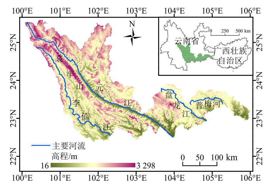
Figure 1 Topographic map of the studied area
| 数据名称 | 数据来源 | 空间分辨率 |
|---|---|---|
| 研究区边界数据 | 国家冰川冻土沙漠科学数据中心 http://www.ncdc.ac.cn | ‒ |
| 高程数据 | 地理空间数据云 https://www.gscloud.cn/home | 30 m分辨率 |
| 气象数据 | 国家青藏高原科学数据中心 https://data.tpdc.ac.cn/ | 1000 m分辨率 |
| 土地利用/覆盖数据 | 中国科学院空天信息创新研究院 https://data.casearth.cn/ | 30 m分辨率 |
| 土壤数据 | 国家地球系统科学中心 https://www.geodata.cn/main/ | 250 m分辨率 |
Table 1 Data sources
| 数据名称 | 数据来源 | 空间分辨率 |
|---|---|---|
| 研究区边界数据 | 国家冰川冻土沙漠科学数据中心 http://www.ncdc.ac.cn | ‒ |
| 高程数据 | 地理空间数据云 https://www.gscloud.cn/home | 30 m分辨率 |
| 气象数据 | 国家青藏高原科学数据中心 https://data.tpdc.ac.cn/ | 1000 m分辨率 |
| 土地利用/覆盖数据 | 中国科学院空天信息创新研究院 https://data.casearth.cn/ | 30 m分辨率 |
| 土壤数据 | 国家地球系统科学中心 https://www.geodata.cn/main/ | 250 m分辨率 |
| 交互作用 | 判据 |
|---|---|
| 非线性减弱 | $q\left(X_{1} \cap X_{2}\right)<\min \left[q\left(X_{1}\right), q\left(X_{2}\right)\right]$ |
| 单因子非线性减弱 | $\min \left[q\left(X_{1}\right), q\left(X_{2}\right)\right]<q\left(X_{1} \cap X_{2}\right)<\max \left[q\left(X_{1}\right), q\left(X_{2}\right)\right]$ |
| $q\left(X_{1} \cap X_{2}\right)>\max \left[q\left(X_{1}\right), q\left(X_{2}\right)\right]$ | |
| 独立 | $q\left(X_{1} \cap X_{2}\right)=q\left(X_{1}\right)+q\left(X_{2}\right)$ |
| 非线性增强 | $q\left(X_{1} \cap X_{2}\right)>q\left(X_{1}\right)+q\left(X_{2}\right)$ |
Table 2 Geographic detector interaction types and judgment criteria
| 交互作用 | 判据 |
|---|---|
| 非线性减弱 | $q\left(X_{1} \cap X_{2}\right)<\min \left[q\left(X_{1}\right), q\left(X_{2}\right)\right]$ |
| 单因子非线性减弱 | $\min \left[q\left(X_{1}\right), q\left(X_{2}\right)\right]<q\left(X_{1} \cap X_{2}\right)<\max \left[q\left(X_{1}\right), q\left(X_{2}\right)\right]$ |
| $q\left(X_{1} \cap X_{2}\right)>\max \left[q\left(X_{1}\right), q\left(X_{2}\right)\right]$ | |
| 独立 | $q\left(X_{1} \cap X_{2}\right)=q\left(X_{1}\right)+q\left(X_{2}\right)$ |
| 非线性增强 | $q\left(X_{1} \cap X_{2}\right)>q\left(X_{1}\right)+q\left(X_{2}\right)$ |
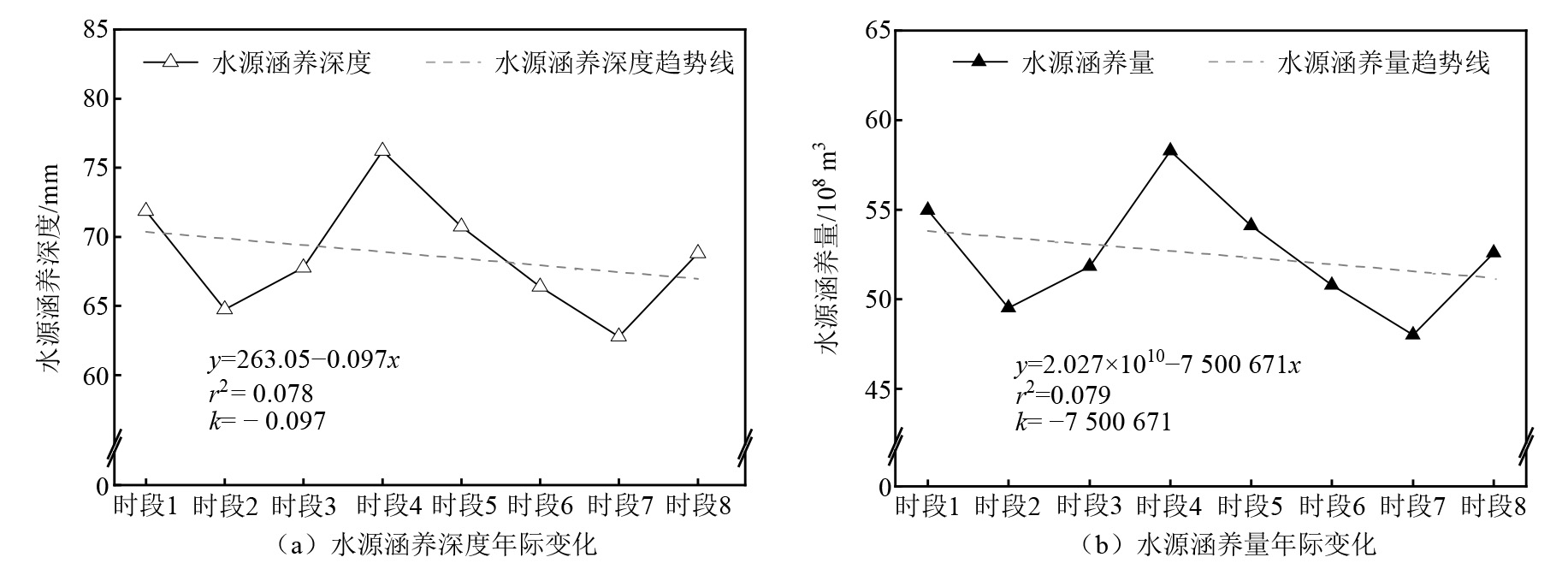
Figure 2 Process of inter-annual changes in water conservation function in the studied area for eight time periods
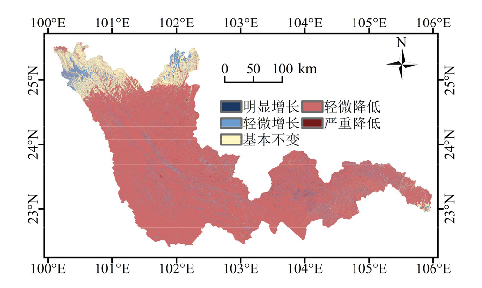
Figure 3 Sen+Mann-Kendall trend analysis of water conservation function in the studied area
| Sen’s slope | Z | 变化趋势 | 面积占比/ % | 平均变化趋势/ (mm·a−1) |
|---|---|---|---|---|
| β>0.1 | |Z|>1.96 | 明显增长 | 0.234 | 5.46 |
| β>0.1 | |Z|£1.96 | 轻微增长 | 2.74 | 2.54 |
| |β|£0.1 | ‒ | 基本不变 | 67.4 | 0.01 |
| β£−0.1 | |Z|£1.96 | 轻微降低 | 29.1 | −0.888 |
| β£−0.1 | |Z|>1.96 | 严重降低 | 0.517 | −4.26 |
Table 3 Classification statistics on the trends of water conservation function in the studied area
| Sen’s slope | Z | 变化趋势 | 面积占比/ % | 平均变化趋势/ (mm·a−1) |
|---|---|---|---|---|
| β>0.1 | |Z|>1.96 | 明显增长 | 0.234 | 5.46 |
| β>0.1 | |Z|£1.96 | 轻微增长 | 2.74 | 2.54 |
| |β|£0.1 | ‒ | 基本不变 | 67.4 | 0.01 |
| β£−0.1 | |Z|£1.96 | 轻微降低 | 29.1 | −0.888 |
| β£−0.1 | |Z|>1.96 | 严重降低 | 0.517 | −4.26 |
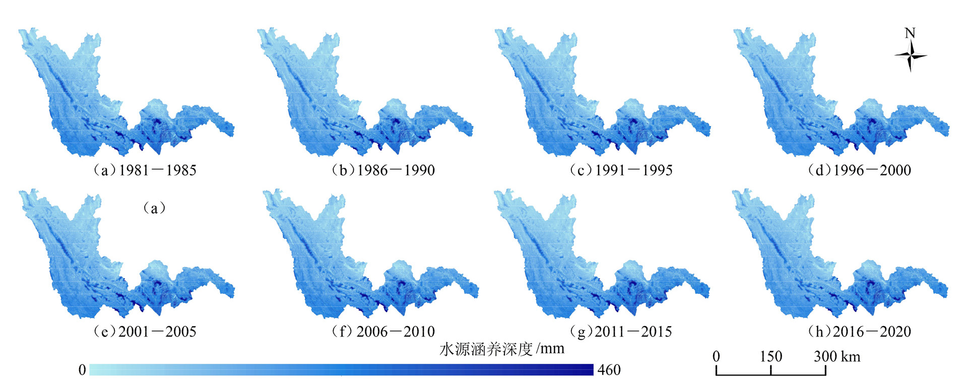
Figure 4 Spatial distribution of the depth of water conservation in the studied area for eight time periods
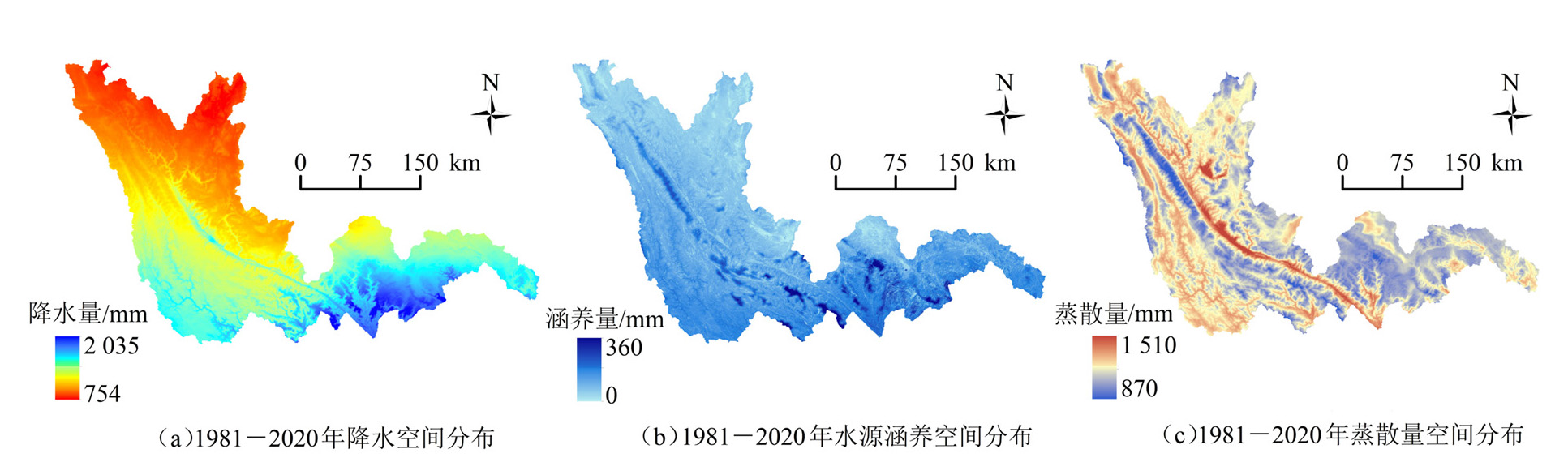
Figure 5 Comparison of the spatial distribution of precipitation, water retention and evapotranspiration from 1981 to 2020
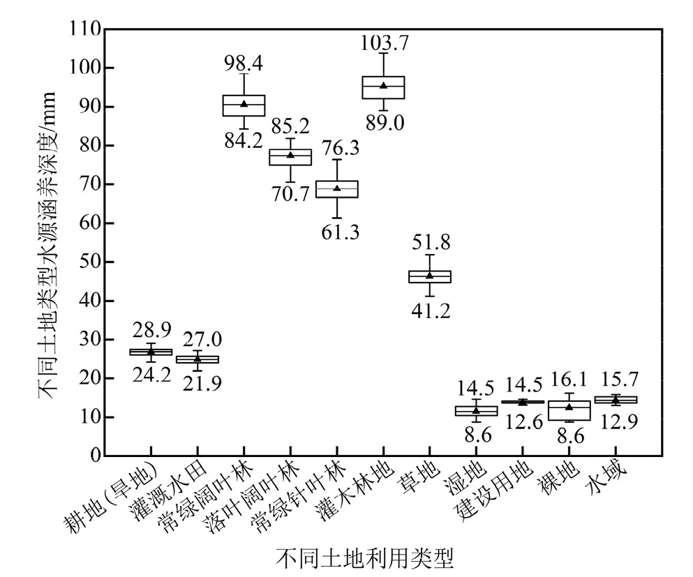
Figure 6 Depth of water conservation for different land use types in the studied area
| 土地利用 类型 | 多年平均水源涵养 | 1981-2020年变化 | ||||
|---|---|---|---|---|---|---|
| 深度/ mm | 涵养量/ m3 | 面积/ km2 | 涵养量/ m3 | 回归趋势/ (m3·a−1) | ||
| 耕地(旱地) | 26.7 | 1.80×10⁸ | 1.21×10³ | −4.66×10⁷ | −1.59×10⁶ | |
| 灌溉水田 | 24.8 | 1.14×10⁷ | −1.25×10² | −4.42×10⁶ | −1.60×10⁵ | |
| 常绿阔叶林 | 90.5 | 1.00×10⁹ | −9.20×10² | −1.37×10⁸ | −4.84×10⁶ | |
| 落叶阔叶林 | 77.2 | 9.54×10⁸ | 2.19×10³ | 1.15×10⁸ | 4.95×10⁶ | |
| 常绿针叶林 | 68.7 | 1.95×10⁹ | −1.81×10³ | −2.27×10⁸ | −7.39×10⁶ | |
| 灌木林地 | 95.2 | 7.23×10⁸ | 1.25×10³ | 7.39×10⁷ | 2.10×10⁶ | |
| 草地 | 46.2 | 4.17×10⁸ | 32 | −1.95×10⁷ | −8.08×10⁵ | |
| 湿地 | 11.4 | 1.20×10⁶ | −8 | −2.68×10⁵ | −3.92×10³ | |
| 建设用地 | 13.7 | 7.68×10⁶ | 5.69×10² | 7.53×10⁶ | 2.30×10⁵ | |
| 裸地 | 12.4 | 3.68×10³ | 2 | 2.45×10⁴ | 4.55×10² | |
| 水域 | 14.3 | 2.29×10⁶ | 40 | 8.96×10⁵ | 2.23×10⁴ | |
Table 4 Water conservation functions and changes in different land uses in the studied area
| 土地利用 类型 | 多年平均水源涵养 | 1981-2020年变化 | ||||
|---|---|---|---|---|---|---|
| 深度/ mm | 涵养量/ m3 | 面积/ km2 | 涵养量/ m3 | 回归趋势/ (m3·a−1) | ||
| 耕地(旱地) | 26.7 | 1.80×10⁸ | 1.21×10³ | −4.66×10⁷ | −1.59×10⁶ | |
| 灌溉水田 | 24.8 | 1.14×10⁷ | −1.25×10² | −4.42×10⁶ | −1.60×10⁵ | |
| 常绿阔叶林 | 90.5 | 1.00×10⁹ | −9.20×10² | −1.37×10⁸ | −4.84×10⁶ | |
| 落叶阔叶林 | 77.2 | 9.54×10⁸ | 2.19×10³ | 1.15×10⁸ | 4.95×10⁶ | |
| 常绿针叶林 | 68.7 | 1.95×10⁹ | −1.81×10³ | −2.27×10⁸ | −7.39×10⁶ | |
| 灌木林地 | 95.2 | 7.23×10⁸ | 1.25×10³ | 7.39×10⁷ | 2.10×10⁶ | |
| 草地 | 46.2 | 4.17×10⁸ | 32 | −1.95×10⁷ | −8.08×10⁵ | |
| 湿地 | 11.4 | 1.20×10⁶ | −8 | −2.68×10⁵ | −3.92×10³ | |
| 建设用地 | 13.7 | 7.68×10⁶ | 5.69×10² | 7.53×10⁶ | 2.30×10⁵ | |
| 裸地 | 12.4 | 3.68×10³ | 2 | 2.45×10⁴ | 4.55×10² | |
| 水域 | 14.3 | 2.29×10⁶ | 40 | 8.96×10⁵ | 2.23×10⁴ | |
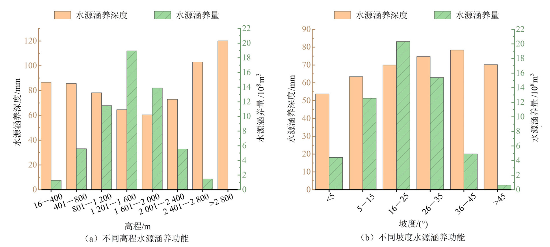
Figure 7 Water conservation functions of different terrains in the studied area
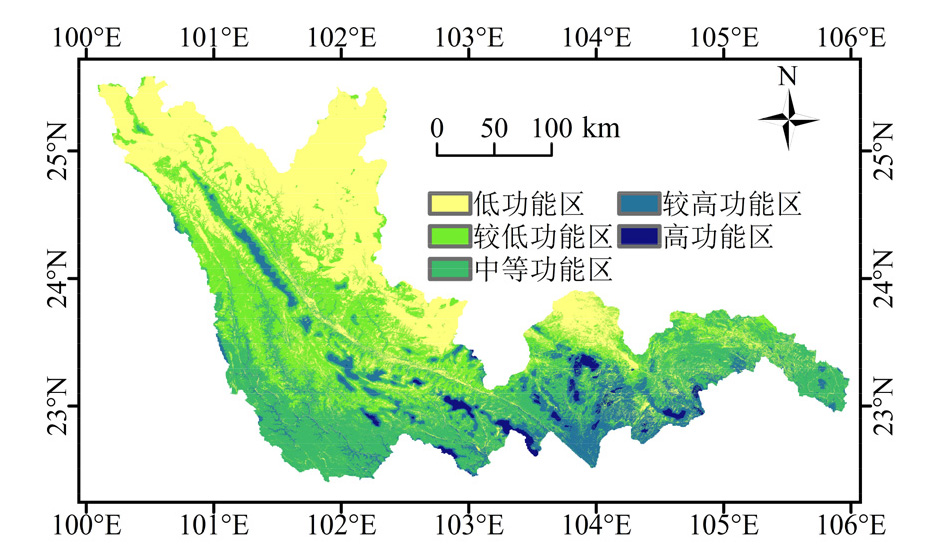
Figure 8 Spatial distribution of water conservation function functional areas in the studied area
| 重要等级 | 功能区等级 | 面积/ km2 | 面积占比/ % | 水源涵养率/ (m3·km−2) |
|---|---|---|---|---|
| 一般重要 | 低功能区 | 2.67×10⁴ | 34.9 | 3.61×10⁴ |
| 较低功能区 | 1.94×10⁴ | 25.4 | 6.31×10⁴ | |
| 中等重要 | 中等功能区 | 2.21×10⁴ | 28.9 | 8.91×10⁴ |
| 重要 | 较高功能区 | 7.16×10³ | 9.37 | 1.19×10⁵ |
| 高功能区 | 1.08×10³ | 1.43 | 1.87×10⁵ |
Table 5 Characteristics of the water conservation function functional areas in the studied area statistics
| 重要等级 | 功能区等级 | 面积/ km2 | 面积占比/ % | 水源涵养率/ (m3·km−2) |
|---|---|---|---|---|
| 一般重要 | 低功能区 | 2.67×10⁴ | 34.9 | 3.61×10⁴ |
| 较低功能区 | 1.94×10⁴ | 25.4 | 6.31×10⁴ | |
| 中等重要 | 中等功能区 | 2.21×10⁴ | 28.9 | 8.91×10⁴ |
| 重要 | 较高功能区 | 7.16×10³ | 9.37 | 1.19×10⁵ |
| 高功能区 | 1.08×10³ | 1.43 | 1.87×10⁵ |
| 驱动因子 | 降水量 | 蒸散发 | 土地利用 | 高程 | 坡度 |
|---|---|---|---|---|---|
| q | 0.539 | 0.219 | 0.307 | 0.088 | 0.049 |
| p | *** | *** | *** | *** | *** |
Table 6 Individual effects of drivers on changes in water conservation functions
| 驱动因子 | 降水量 | 蒸散发 | 土地利用 | 高程 | 坡度 |
|---|---|---|---|---|---|
| q | 0.539 | 0.219 | 0.307 | 0.088 | 0.049 |
| p | *** | *** | *** | *** | *** |
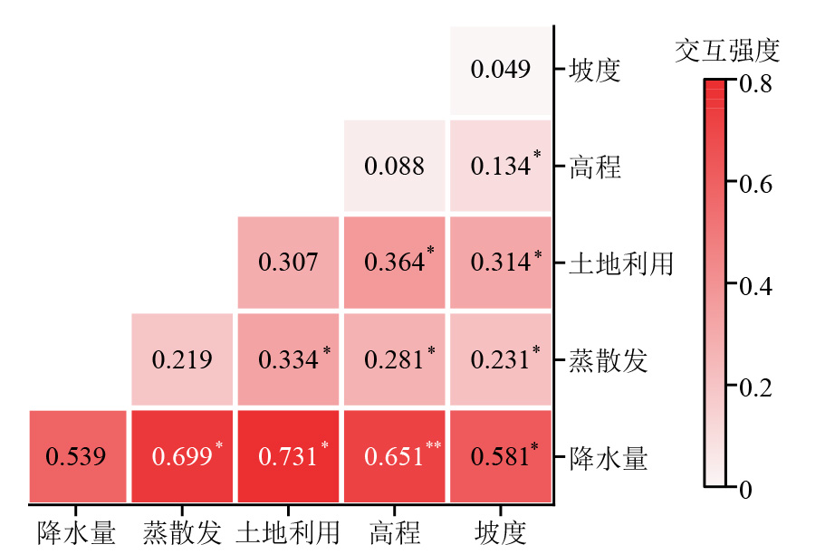
Figure 9 Interaction detection results of driving factors
| [1] |
DECSI B, VARI A, KOZMA Z, 2020. The effect of future land use changes on hydrologic ecosystem services: A case study from the Zala catchment, Hungary[J]. Biologia Futura, 71(4): 405-418.
DOI PMID |
| [2] | COSBY B J, HORNBERGER G M, CLAPP R B, et al., 1984. A statistical exploration of the relationships of soil moisture characteristics to the physical properties of soils[J]. Water Resources Research, 20(6): 682-690. |
| [3] | COSTANZA R, D'ARGE R, DE G R, et al., 1997. The value of the world’s ecosystem services and natural capital[J]. Nature, 387(6630): 253-260. |
| [4] | DROOGERS P, ALLEN R G, 2002. Estimating reference evapotmnspimtion under inaccurate data conditions[J]. Irrigation and Dminage Systems, 16(1): 33-45. |
| [5] | JIANG H, WU Y F, 2021. Change trend analysis of the time-series shadow-eliminated vegetation index (SEVI) for the Wuyishan Nature Reserve with the Sen+Mann-Kendall method[J]. IOP Conference Series: Earth and Environmental Science, 658(1): 12-16. |
| [6] | LEH D M, MATLOCK D M, CUMMINGS C E, et al., 2013. Quantifying and mapping multiple ecosystem services change in West Africa[J]. Agriculture, Ecosystems and Environment, 165: 6-18. |
| [7] | LIANG Y T, XU C D, 2023. Knowledge diffusion of Geodetector: A perspective of the literature review and Geotree[J]. Heliyon, 9(9): 19651-19651. |
| [8] | MARTIN K, MARTIN M, JAN W, 2021. Topographic Wetness Index calculation guidelines based on measured soil moisture and plant species composition[J]. Science of The Total Environment, 757(1): 143785. |
| [9] | MOMBLANCH A, ARQUIOLA J P, ANDREU J, et al., 2017. Improved modelling of the freshwater provisioning ecosystem service in water scarce river basins[J]. Environmental Modelling & Software, 94(8): 87-99. |
| [10] | MONTSE M, RUBAB F B, VIKAS K, et al., 2013. The impact of climate change on water provision under a low flow regime: A case study of the ecosystems services in the Francoli river basin[J]. Journal of Hazardous Materials, 263(12): 224-232. |
| [11] |
柏松, 景连东, 李晖, 等, 2017. 基于水源涵养功能的生态红线划定方法研究[J]. 生态环境学报, 26(10): 1665-1670.
DOI |
| BAI S, JING LD, LI H, et al., 2017. The demarcation of ecological protection red line based on water conversation function[J]. Ecology and Environmental Sciences, 26(10): 1665-1670. | |
| [12] | 代兴兰, 2008. 红河流域泥沙特性与水土保持[J]. 人民珠江, 46(3): 22-23. |
| DAI X L, 2008. Sediment characteristics and soil and water conservation in the honghe watershed[J]. Pearl River, 46(3): 22-23. | |
| [13] | 傅斌, 徐佩, 王玉宽, 等, 2013. 都江堰市水源涵养功能空间格局[J]. 生态学报, 33(3): 789-797. |
| FU B, XU P, WANG Y K, et al., 2013. Spatial Pattern of water retetnion in Dujiagyan County[J]. Acta Ecologica Sinica, 33(3): 789-797. | |
| [14] | 韩念龙, 刘子荣, 贾培宏, 等, 2022. 1996-2020年海南岛水源涵养量时空变化及地理探测[J]. 水土保持通报, 42(5): 193-201. |
| HAN N L, LIU Z R, JIA P H, et al., 2022. Spatio-temporal changes and geographic detection of water conservation on Hainan Island from 1996 to 2020[J]. Bulletin of Soil and Water Conservation, 42(5): 193-201. | |
| [15] | 贾雨凡, 杨勤丽, 胡非池, 等, 2022. 变化环境下的水源涵养能力评估研究进展[J]. 水利水运工程学报 (1): 37-47. |
| JIA Y F, YANG Q L, HU F C, et al., 2022. Prospect and progress of water conservation capacity evaluation in a changing environment[J]. Hydro-Science and Engineering (1): 37-47. | |
| [16] | 李卉, 朱彤彤, 刘侦海, 等, 2022. 东南亚沿海与内陆植被对洪水事件响应的稳定性差异[J]. 生态学报, 42(16): 6745-6757. |
| LI H, ZHU T T, LIU Z H, et al., 2022. Stability differences of coastal and inland vegetation to flood events in Southeast Asia[J]. Acta Ecologica Sinica, 42(16): 6745-6757. | |
| [17] |
李惠梅, 李荣杰, 晏旭昇, 等, 2023. 青海湖流域生态风险评价及生态功能分区研究[J]. 生态环境学报, 32(7): 1185-1195.
DOI |
| LI H M, LI R J, YAN X S, et al., 2023. The ecological function zoning of Qinghai Lake Basin based on ecological risk assessment[J]. Ecology and Environmental Sciences, 32(7): 1185-1195. | |
| [18] | 李双成, 刘金龙, 张才玉, 等, 2011. 生态系统服务研究动态及地理学研究范式[J]. 地理学报, 66(12): 1618-1630. |
| LI S C, LIU J L, ZHANG C Y, et al., 2021. The research trends of ecosystem services and the paradigm in geography[J]. Acta Geographica Sinica, 66(12): 1618-1630. | |
| [19] | 刘娇, 郎学东, 苏建荣, 等, 2021. 基于INVEST模型的金沙江流域干热河谷区水源涵养功能评估[J]. 生态学报, 41(20): 8099-8111. |
| LIU J, LANG X D, SU J R, et al., 2021. Evaluation of water conservation function in the dry-hot valley area of Jinsha River Basin based on InVEST model[J]. Acta Ecologica Sinica, 41(20): 8099-8111. | |
| [20] | 刘晶, 鲍振鑫, 刘翠善, 等, 2019. 近20年中国水资源及用水量变化规律与成因分析[J]. 水利水运工程学报 (4): 31-41. |
| LIU J, BAO Z X, LIU C S, et al., 2019. Change law and cause analysis of water resources and water consumption in China in past 20 years[J]. Hydro-Science and Engineering (4): 31-41. | |
| [21] | 刘世梁, 刘琦, 张兆苓, 等, 2014. 云南省红河流域景观生态风险及驱动力分析[J]. 生态学报, 34(13): 3728-3734. |
| LIU S L, LIU Q, ZHANG Z L, et al., 2014. Landscape ecological risk and driving force analysis in Red river Basin[J]. Acta Ecologica Sinica, 34(13): 3728-3734. | |
| [22] | 吕乐婷, 任甜甜, 孙才志, 等, 2020. 1980-2016年三江源国家公园水源供给及水源涵养功能时空变化研究[J]. 生态学报, 40(3): 993-1003. |
| LÜ L T, REN T T, SUN C Z, et al., 2020. Spatial and temporal changes of water supply and water conservation function in Sanjiangyuan National Park from 1980 to 2016[J]. Acta Ecologica Sinica, 40(3): 993-1003. | |
| [23] | 吕明轩, 张红, 贺桂珍, 等, 2024. 黄河流域水源涵养服务功能动态演变及驱动因素[J]. 生态学报, 44(7): 2761-2771. |
| LÜ M X, ZHANG H, HE G Z, et al., 2024. Dynamic evolution and driving factors of water conservation service function in the Yellow River Basin[J]. Acta Ecologica Sinica, 44(7): 2761-2771. | |
| [24] | 欧阳志云, 朱春全, 杨广斌, 等, 2013. 生态系统生产总值核算: 概念、核算方法与案例研究[J]. 生态学报, 33(21): 6747-6761. |
| OUYANG Z Y, ZHU C Q, YANG G B, et al., 2013. Gross ecosystem product: concept, accounting framework and case study[J]. Acta Ecologica Sinica, 33(21): 6747-6761. | |
| [25] | 潘韬, 吴绍洪, 戴尔阜, 等, 2013. 基于InVEST模型的三江源区生态系统水源供给服务时空变化[J]. 应用生态学报, 24(1): 183-189. |
| PAN T, WU S H, DAI E F, et al., 2013. Spatiotemporal variation of water source supply service in Three Rivers Source Area of China based on InVEST model[J]. Chinese Journal of Applied Ecology, 24(1): 183-189. | |
| [26] | 王佃来, 刘文萍, 黄心渊, 2013. 基于Sen+Mann-Kendall的北京植被变化趋势分析[J]. 计算机工程与应用, 49(5): 13-17. |
| WANG D L, LIU W P, HUANG X Y, 2013. Trend analysis in vegetation cover in Beijing based on Sen+Mann-Kendall method[J]. Computer Engineering and Applications, 49(5): 13-17. | |
| [27] |
王劲峰, 徐成东, 2017. 地理探测器: 原理与展望[J]. 地理学报, 72(1): 116-134.
DOI |
|
WANG J F, XU D C, 2017. Geodetector: Principle and prospective[J]. Acta Geographica Sinica, 72(1): 116-134.
DOI |
|
| [28] |
王鹭莹, 李小马, 甘德欣, 等, 2024. 长株潭城市群生态系统服务权衡与协同关系的空间异质性及其驱动因素[J]. 生态环境学报, 33(6): 969-979.
DOI |
| WANG L Y, LI X M, GAN D X, et al., 2024. Spatial heterogeneity and driving factors of ecosystem service trade-offs and synergies in the Changsha-Zhuzhou-Xiangtan urban agglomeration[J]. Ecology and Environmental Sciences, 33(6): 969-979. | |
| [29] | 谢淑琴, 2002. 红河流域水文特性[J]. 水文, 22(4): 57-58, 63. |
| XIE S Q, 2002. The hydrological characteristics of the Red River Basin[J]. Hydrology, 22(4): 57-58, 63. | |
| [30] | 叶长青, 甘淑, 李运刚, 2008. 红河流域降水量的时空变异特征[J]. 云南大学学报(自然科学版), 30(1): 54-60. |
| YE C Q, GAN S, LI Y G, 2008. The temporal and spatial variation characteristics analysis of precipitation in Honghe River basin[J]. Journal of Yunnan University: Natural Sciences Edition, 30(1): 54-60. | |
| [31] | 余新晓, 周彬, 吕锡芝, 等, 2012. 基于InVEST模型的北京山区森林水源涵养功能评估[J]. 林业科学, 48(10): 1-5. |
| YU X X, ZHOU B, LÜ X Z, et al., 2012. Evaluation of water conservation function in mountain forest areas of Beijing based on InVEST model[J]. Scientia Silvae Sinicae, 48(10): 1-5. | |
| [32] | 张彪, 李文华, 谢高地, 等, 2009. 森林生态系统的水源涵养功能及其计量方法[J]. 生态学杂志, 28(3): 529-534. |
| ZHANG B, LI W H, XIE G D, et al., 2009. Water conservation function and its m easurem ent m ethods of forest ecosystem[J]. Chinese Joumal of Ecology, 28(3): 529-534. | |
| [33] | 张彪, 李文华, 谢高地, 等, 2008. 北京市森林生态系统的水源涵养功能[J]. 生态学报, 28(11): 5619-5624. |
| ZHANG B, LI W H, XIE G D, et al., 2008. Characteristics of water conservation of forest ecosystem in Beijing[J]. Acta Ecologica Sinica, 28(11): 5618-5624. | |
| [34] | 张昌顺, 谢高地, 刘春兰, 等, 2022. 基于水源涵养参照系的中国生态系统水源涵养功能优劣评估[J]. 生态学报, 42(22): 9250-9260. |
| ZHANG C S, XIE G D, LIU C L, et al., 2022. Evaluation of water conservation of China’s ecosystems based on benchmark[J]. Acta Ecologica Sinica, 42(22): 9250-9260. | |
| [35] |
张福平, 李肖娟, 冯起, 等, 2018. 基于InVEST模型的黑河流域上游水源涵养量[J]. 中国沙漠, 38(6): 1321-1329.
DOI |
|
ZHANG F P, LI X J, FENG Q, et al., 2018. Spatial and temporal variation of water conservation in the upper reaches of Heihe River Basin Based on InVEST model[J]. Journal of Desert Research, 38(6): 1321-1329.
DOI |
|
| [36] | 中华人民共和国生态环境部, 2020. 生态保护红线监管技术规范生态功能评价(试行)[EB/OL]. (2020-11-24) [2024-12-06]. https://www.mee.gov.cn/ywgz/fgbz/bz/bzwb/stzl/202011/W020201127553309828533. |
| Ministry of Ecology and Environment of the People's Republic of China,2020. Technical specification for supervision of ecological conservation redline-Ecological function evaluation (on trial)[EB/OL]. (2020-11-24) [2024-12-06]. https://www.mee.gov.cn/ywgz/fgbz/bz/bzwb/stzl/202011/W020201127553309828533. . | |
| [37] | 周文佐, 2003. 基于GIS的我国主要土壤类型土壤有效含水量研究[D]. 南京: 南京农业大学: 1-79. |
| ZHOU W Z, 2003. Study on available water capacity of main soil types in china based on geographic information system[D]. Nanjing: Nanjing Agricultural University: 1-79. | |
| [38] | 周雪彤, 孙文义, 穆兴民, 等, 2023. 1990-2020年三江源水源涵养能力时空变化及影响因素[J]. 生态学报, 43(23): 9844-9855. |
| ZHOU X T, SUN W Y, MU X M, et al., 2023. Spatiotemporal variation and influencing factors of water conservation capacity in Three-River Headwaters region from 1990 to 2020[J]. Acta Ecologica Sinica, 43(23): 9844-9855. |
| [1] | ZHANG Renfei, XIAO Meng, LIU Zhicheng. Spatio-temporal Heterogeneity and Driving Factors of Landscape Fragmentation in Beijing-Tianjin-Hebei Region [J]. Ecology and Environmental Sciences, 2025, 34(3): 461-473. |
| [2] | LI Man, WU Dongli, HE Hao, YU Huijie, ZHAO Lin, LIU Cong, HU Zhenghua, LI Qi. Spatio-temporal Evolution and Driving Factors of Carbon Storage in the Yellow River Basin from 1990 to 2020 [J]. Ecology and Environmental Sciences, 2025, 34(3): 333-344. |
| [3] | ZHANG Ji, YANG Shiqi, ZHAO Lei, FENG Jieling, CHEN Yanying. Spatiotemporal Evolution Characteristics of Habitat Quality in the One Belt and Three Barriers Region of Chongqing City Based on the InVEST Model [J]. Ecology and Environmental Sciences, 2025, 34(2): 167-180. |
| [4] | MA Yuewei, CHEN Yumei, ZHANG Shenglan, GUI Yali, CHEN Yanmei. Coupling and Coordination of Habitat Quality and Human Activity Intensity in Jiajin Mountains Giant Panda Sanctuary [J]. Ecology and Environmental Sciences, 2025, 34(2): 197-208. |
| [5] | LU Dehao, ZHENG Fenglin, GU Jiawei, SHUAI Xiaomai, YANG Jiaman, LI Cheng, CAI Mengzhen, CHEN Hongyue. Analysis and Evaluation of Litter and Soil Water Conservation Capacity of Different Stand Types [J]. Ecology and Environmental Sciences, 2025, 34(1): 26-35. |
| [6] | TANG Jianting, YUAN Jie, CHEN Zongyan, LI Xiaoyan, SUN Ziting. Study on Land Use Change and Carbon Stock on the South Slope of Qilian Mountains [J]. Ecology and Environmental Sciences, 2024, 33(9): 1353-1361. |
| [7] | ZHANG Wen, ZHENG Tian, LIU Yongchao, ZHONG Jie, SU Jie, LI Jialin. Identification of Key Areas for Ecological Protection and Restoration in Zhejiang Province Based on Circuit Theory [J]. Ecology and Environmental Sciences, 2024, 33(9): 1482-1494. |
| [8] | DAI Xiaoai, MA Jiaxin, TANG Yiling, LI Weile. Spatio-temporal Dynamics and Attribution Analysis of Vegetation in Gansu Province [J]. Ecology and Environmental Sciences, 2024, 33(8): 1163-1173. |
| [9] | WANG Xuerong, GONG Jianzhou, YU Fangyuan. Mutual Feedback Relationships and Mechanisms of Ecosystem Four Regulating Services in the Greater Bay Area of Guangdong, Hongkong and Macao [J]. Ecology and Environmental Sciences, 2024, 33(7): 1130-1141. |
| [10] | WANG Wen, HOU Qingqing, PEI Tingting. Impact of the Slope on Ecosystem Services in Hedong District of Gansu Province, China [J]. Ecology and Environmental Sciences, 2024, 33(7): 1117-1129. |
| [11] | LIAO Hongsheng, WEI Wei, SHI Yu. Characteristics of Spatial and Temporal Evolution of Soil Erosion in Typical Watersheds in Loess Hilly Areas and Its Driving Mechanisms: A Case Study of Zuli River [J]. Ecology and Environmental Sciences, 2024, 33(6): 908-918. |
| [12] | TIAN Chengshi, SUN Ruixin. Spatial Heterogeneity and Its Influential Factors of Eco-environmental Quality in the Yangtze River Economic Belt: Based on Land Use Transformation of Production, Living and Ecological Spaces [J]. Ecology and Environmental Sciences, 2023, 32(7): 1173-1184. |
| [13] | WANG Lin, WEI Wei. Characteristics and Driving Factors of Ecosystem Services Changes in A Typical County of the Loess Plateau [J]. Ecology and Environmental Sciences, 2023, 32(6): 1140-1148. |
| [14] | LI Jianhui, DANG Zheng, CHEN Lin. Spatial-temporal Characteristics of PM2.5 and Its Influencing Factors in the Yellow River Jiziwan Metropolitan Area [J]. Ecology and Environmental Sciences, 2023, 32(4): 697-705. |
| [15] | ZHANG Pingjiang, DANG Guofeng. Construction of Ecological Security Pattern of Tao River Basin Based on MCR Model and ant Colony Algorithm [J]. Ecology and Environmental Sciences, 2023, 32(3): 481-491. |
| Viewed | ||||||
|
Full text |
|
|||||
|
Abstract |
|
|||||
Copyright © 2021 Editorial Office of ACTA PETROLEI SINICA
Address:No. 6 Liupukang Street, Xicheng District, Beijing, P.R.China, 510650
Tel: 86-010-62067128, 86-010-62067137, 86-010-62067139
Fax: 86-10-62067130
Email: syxb@cnpc.com.cn
Support byBeijing Magtech Co.ltd, E-mail:support@magtech.com.cn