Ecology and Environment ›› 2024, Vol. 33 ›› Issue (7): 1027-1035.DOI: 10.16258/j.cnki.1674-5906.2024.07.004
• Research Article [Ecology] • Previous Articles Next Articles
YANG Keming1( ), PENG Lishun1,*(), ZHANG Yanhai2, GU Xinru1, CHEN Xinyang1, JIANG Kegui1
Received:2024-04-15
Online:2024-07-18
Published:2024-09-04
Contact:
PENG Lishun
杨可明1(), 彭里顺1,*(), 张燕海2, 谷新茹1, 陈新阳1, 江克贵1
通讯作者:
彭里顺
作者简介:杨可明(1969年生),男,教授,博士研究生导师,主要从事高光谱遥感、矿山地理与形变信息研究。E-mail: ykm69@163.com
基金资助:CLC Number:
YANG Keming, PENG Lishun, ZHANG Yanhai, GU Xinru, CHEN Xinyang, JIANG Kegui. Research on Biomass Inversion of Multiple Vegetation Types on the Surface of Mining Areas[J]. Ecology and Environment, 2024, 33(7): 1027-1035.
杨可明, 彭里顺, 张燕海, 谷新茹, 陈新阳, 江克贵. 淮北矿区多种类型植被地上生物量反演研究[J]. 生态环境学报, 2024, 33(7): 1027-1035.
Add to citation manager EndNote|Ris|BibTeX
URL: https://www.jeesci.com/EN/10.16258/j.cnki.1674-5906.2024.07.004
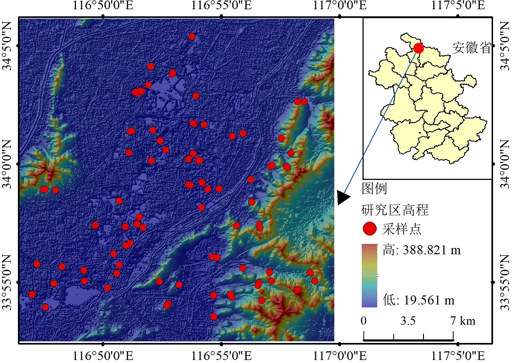
Figure 1 Map of the location of the studied area
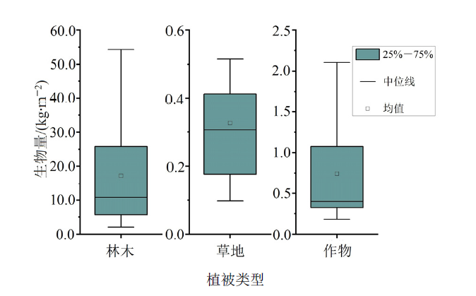
Figure 2 The Distribution ranges of aboveground biomass in forest, agricultural, and grassland areas within the studied area
| 特征名称 | 计算公式 | 引用 |
|---|---|---|
| 增强植被指数 | 2.5×[(B8−B4)/(B8+6×B4−7.5×B2+1)] | Miura et al., |
| 归一化差值水体指数 | (B3−B8)/(B3+B8) | Mcfeeters, |
| 比值植被指数 | B8/B4 | Huang et al., |
| 差值植被指数 | B8−B4 | 王雪梅等, |
| 归一化植被指数 | (B8−B4)/(B8+B4) | 惠嘉伟等, |
| 修正归一化差值水体指数 | (B3−B11)/(B3+B11) | Xu, |
| 叶绿素指数-绿光 | (B8/B3)−1 | Gitelson et al., |
| Sentinel-2红边位置 | 705+35×{{[(B7+B4)/2]−B5}/(B6−B5)} | Ali et al., |
| 修正土壤调节植被指数 | 0.5×{2×(B8+1)−sqrt[(2×B8+1)×2−8×(B8−B4)]} | Qi et al., |
| 归一化差值建筑用地指数 | (B11−B8)/(B11+B8) | Zha et al., |
| 叶绿素指数-红边 | (B8/B5)−1 | Gitelson et al., |
| 陆地叶绿素指数 | (B6−B5)/(B5+B4) | Dash et al., |
| 红边三角植被指数 | 100×(B8−B5)−10×(B8−83) | Haboudane et al., |
| 修正型三角植被指数 | 1.5×[1.2(B8−B3)−2.5×(B4−B3)]sqrt{(2×B8+1)²−[6×B8−5sqrt(B4)]−0.5} | Haboudane et al., |
Table 1 List of spectral indices
| 特征名称 | 计算公式 | 引用 |
|---|---|---|
| 增强植被指数 | 2.5×[(B8−B4)/(B8+6×B4−7.5×B2+1)] | Miura et al., |
| 归一化差值水体指数 | (B3−B8)/(B3+B8) | Mcfeeters, |
| 比值植被指数 | B8/B4 | Huang et al., |
| 差值植被指数 | B8−B4 | 王雪梅等, |
| 归一化植被指数 | (B8−B4)/(B8+B4) | 惠嘉伟等, |
| 修正归一化差值水体指数 | (B3−B11)/(B3+B11) | Xu, |
| 叶绿素指数-绿光 | (B8/B3)−1 | Gitelson et al., |
| Sentinel-2红边位置 | 705+35×{{[(B7+B4)/2]−B5}/(B6−B5)} | Ali et al., |
| 修正土壤调节植被指数 | 0.5×{2×(B8+1)−sqrt[(2×B8+1)×2−8×(B8−B4)]} | Qi et al., |
| 归一化差值建筑用地指数 | (B11−B8)/(B11+B8) | Zha et al., |
| 叶绿素指数-红边 | (B8/B5)−1 | Gitelson et al., |
| 陆地叶绿素指数 | (B6−B5)/(B5+B4) | Dash et al., |
| 红边三角植被指数 | 100×(B8−B5)−10×(B8−83) | Haboudane et al., |
| 修正型三角植被指数 | 1.5×[1.2(B8−B3)−2.5×(B4−B3)]sqrt{(2×B8+1)²−[6×B8−5sqrt(B4)]−0.5} | Haboudane et al., |
| 方案分组名称 | 光谱特征组合 (特征数) |
|---|---|
| A | 原始波段 (12个) |
| B | 原始波段+光谱指数 (17个) |
| C | 原始波段+自建光谱特征 (17个) |
| D | 原始波段+光谱指数+自建光谱特征 (22个) |
| E | 光谱指数+自建光谱特征 (17个) |
Table 2 Spectral feature extraction schemes for machine learning
| 方案分组名称 | 光谱特征组合 (特征数) |
|---|---|
| A | 原始波段 (12个) |
| B | 原始波段+光谱指数 (17个) |
| C | 原始波段+自建光谱特征 (17个) |
| D | 原始波段+光谱指数+自建光谱特征 (22个) |
| E | 光谱指数+自建光谱特征 (17个) |
| 方程名称 | 函数形式 |
|---|---|
| 线性 | y=ax+b |
| 二次多项式 | y=ax2+bx+c |
| 复合曲线 | y=a×bx |
| 三次曲线 | y=ax3+bx2+bx+d |
| 指数 | y=b×eax |
| 幂函数 | y=b×xa |
Table 3 Traditional regression equations used in the studied area
| 方程名称 | 函数形式 |
|---|---|
| 线性 | y=ax+b |
| 二次多项式 | y=ax2+bx+c |
| 复合曲线 | y=a×bx |
| 三次曲线 | y=ax3+bx2+bx+d |
| 指数 | y=b×eax |
| 幂函数 | y=b×xa |
| 传统方程 回归模型 | 拟合波段 | 训练集 | 验证集 | |||||
|---|---|---|---|---|---|---|---|---|
| R2 | σRMSE/(kg∙m−2) | σRPD | R2 | σRMSE/(kg∙m−2) | σRPD | |||
| 线性 | B1/B12 | 0.47 | 11.92 | 1.37 | 0.34 | 9.30 | 1.23 | |
| 二次方程 | (B1−B5)/(B1+B5) | 0.54 | 11.07 | 1.47 | 0.35 | 9.24 | 1.24 | |
| 复合曲线 | B3+B12 | 0.52 | 11.36 | 1.44 | 0.49 | 8.18 | 1.40 | |
| 三次曲线 | B6/B8A | 0.60 | 10.39 | 1.58 | 0.49 | 8.18 | 1.40 | |
| 指数方程 | B1/B5 | 0.51 | 11.47 | 1.43 | 0.35 | 9.21 | 1.24 | |
Table 4 Comparison of regression model accuracy on integrated data
| 传统方程 回归模型 | 拟合波段 | 训练集 | 验证集 | |||||
|---|---|---|---|---|---|---|---|---|
| R2 | σRMSE/(kg∙m−2) | σRPD | R2 | σRMSE/(kg∙m−2) | σRPD | |||
| 线性 | B1/B12 | 0.47 | 11.92 | 1.37 | 0.34 | 9.30 | 1.23 | |
| 二次方程 | (B1−B5)/(B1+B5) | 0.54 | 11.07 | 1.47 | 0.35 | 9.24 | 1.24 | |
| 复合曲线 | B3+B12 | 0.52 | 11.36 | 1.44 | 0.49 | 8.18 | 1.40 | |
| 三次曲线 | B6/B8A | 0.60 | 10.39 | 1.58 | 0.49 | 8.18 | 1.40 | |
| 指数方程 | B1/B5 | 0.51 | 11.47 | 1.43 | 0.35 | 9.21 | 1.24 | |
| 机器学习 回归模型 | R2 | σRMSE/(kg∙m−2) | σRPD | ||||||||||||||
|---|---|---|---|---|---|---|---|---|---|---|---|---|---|---|---|---|---|
| A | B | C | D | E | A | B | C | D | E | A | B | C | D | E | |||
| SVR | 0.69 | 0.73 | 0.74 | 0.73 | 0.67 | 8.84 | 8.22 | 8.14 | 8.25 | 9.07 | 1.80 | 1.92 | 1.96 | 1.92 | 1.74 | ||
| DTR | 0.65 | 0.65 | 0.65 | 0.65 | 0.43 | 9.87 | 9.87 | 9.87 | 9.87 | 16.57 | 1.69 | 1.69 | 1.69 | 1.69 | 1.32 | ||
| KNNR | 0.69 | 0.55 | 0.66 | 0.59 | 0.45 | 8.86 | 10.67 | 10.34 | 11.2 | 11.78 | 1.80 | 1.49 | 1.71 | 1.56 | 1.35 | ||
| Ridge-R | 0.57 | 0.68 | 10.37 | 8.96 | 1.52 | 1.77 | |||||||||||
| Lasso-R | 0.35 | 0.47 | 12.56 | 11.4 | 1.24 | 1.37 | |||||||||||
| RFR | 0.63 | 0.63 | 0.66 | 0.64 | 0.51 | 9.86 | 9.81 | 9.93 | 9.69 | 12.43 | 1.64 | 1.64 | 1.71 | 1.67 | 1.43 | ||
| GBR | 0.62 | 0.68 | 0.67 | 0.68 | 0.53 | 9.79 | 9.53 | 9.16 | 8.95 | 11.96 | 1.62 | 1.77 | 1.74 | 1.77 | 1.46 | ||
Table 5 Comparison of accuracy of machine learning models on integrated data
| 机器学习 回归模型 | R2 | σRMSE/(kg∙m−2) | σRPD | ||||||||||||||
|---|---|---|---|---|---|---|---|---|---|---|---|---|---|---|---|---|---|
| A | B | C | D | E | A | B | C | D | E | A | B | C | D | E | |||
| SVR | 0.69 | 0.73 | 0.74 | 0.73 | 0.67 | 8.84 | 8.22 | 8.14 | 8.25 | 9.07 | 1.80 | 1.92 | 1.96 | 1.92 | 1.74 | ||
| DTR | 0.65 | 0.65 | 0.65 | 0.65 | 0.43 | 9.87 | 9.87 | 9.87 | 9.87 | 16.57 | 1.69 | 1.69 | 1.69 | 1.69 | 1.32 | ||
| KNNR | 0.69 | 0.55 | 0.66 | 0.59 | 0.45 | 8.86 | 10.67 | 10.34 | 11.2 | 11.78 | 1.80 | 1.49 | 1.71 | 1.56 | 1.35 | ||
| Ridge-R | 0.57 | 0.68 | 10.37 | 8.96 | 1.52 | 1.77 | |||||||||||
| Lasso-R | 0.35 | 0.47 | 12.56 | 11.4 | 1.24 | 1.37 | |||||||||||
| RFR | 0.63 | 0.63 | 0.66 | 0.64 | 0.51 | 9.86 | 9.81 | 9.93 | 9.69 | 12.43 | 1.64 | 1.64 | 1.71 | 1.67 | 1.43 | ||
| GBR | 0.62 | 0.68 | 0.67 | 0.68 | 0.53 | 9.79 | 9.53 | 9.16 | 8.95 | 11.96 | 1.62 | 1.77 | 1.74 | 1.77 | 1.46 | ||
| 传统方程 回归模型 | 拟合波段 | 训练集 | 验证集 | |||||
|---|---|---|---|---|---|---|---|---|
| R2 | σRMSE/(kg∙m−2) | σRPD | R2 | σRMSE/(kg∙m−2) | σRPD | |||
| 线性 | (B6+B9)/(B6−B9) | 0.46 | 10.14 | 1.34 | 0.44 | 11.83 | 1.36 | |
| 二次方程 | (B3−B9)/(B3+B9) | 0.54 | 9.33 | 1.46 | 0.53 | 10.91 | 1.47 | |
| 复合曲线 | B3 | 0.56 | 9.18 | 1.45 | 0.53 | 10.84 | 1.51 | |
| 三次曲线 | (B1−B4)/(B1+B4) | 0.52 | 9.52 | 1.40 | 0.49 | 11.26 | 1.44 | |
| 指数方程 | B5/B7 | 0.41 | 10.61 | 1.35 | 0.45 | 11.69 | 1.30 | |
| 幂函数 | (B3−B9)/(B3+B9) | 0.54 | 9.33 | 1.56 | 0.59 | 10.09 | 1.47 | |
Table 6 Comparison of regression model accuracy for forest data
| 传统方程 回归模型 | 拟合波段 | 训练集 | 验证集 | |||||
|---|---|---|---|---|---|---|---|---|
| R2 | σRMSE/(kg∙m−2) | σRPD | R2 | σRMSE/(kg∙m−2) | σRPD | |||
| 线性 | (B6+B9)/(B6−B9) | 0.46 | 10.14 | 1.34 | 0.44 | 11.83 | 1.36 | |
| 二次方程 | (B3−B9)/(B3+B9) | 0.54 | 9.33 | 1.46 | 0.53 | 10.91 | 1.47 | |
| 复合曲线 | B3 | 0.56 | 9.18 | 1.45 | 0.53 | 10.84 | 1.51 | |
| 三次曲线 | (B1−B4)/(B1+B4) | 0.52 | 9.52 | 1.40 | 0.49 | 11.26 | 1.44 | |
| 指数方程 | B5/B7 | 0.41 | 10.61 | 1.35 | 0.45 | 11.69 | 1.30 | |
| 幂函数 | (B3−B9)/(B3+B9) | 0.54 | 9.33 | 1.56 | 0.59 | 10.09 | 1.47 | |
| 机器学习 回归模型 | R2 | σRMSE/(kg∙m−2) | σRPD | ||||||||||||||
|---|---|---|---|---|---|---|---|---|---|---|---|---|---|---|---|---|---|
| A | B | C | D | E | A | B | C | D | E | A | B | C | D | E | |||
| SVR | 0.79 | 0.80 | 0.79 | 0.80 | 0.76 | 5.95 | 5.83 | 5.98 | 5.91 | 6.48 | 2.16 | 2.41 | 2.22 | 2.12 | 2.35 | ||
| DTR | 0.46 | 0.46 | 0.46 | 0.46 | 9.59 | 9.59 | 9.59 | 9.59 | 1.34 | 1.47 | 1.28 | 1.31 | |||||
| KNNR | 0.75 | 0.77 | 0.73 | 0.73 | 0.69 | 6.52 | 6.30 | 6.80 | 6.81 | 7.31 | 1.97 | 2.23 | 1.73 | 1.85 | 2.07 | ||
| Ridge-R | 0.74 | 0.80 | 0.73 | 0.75 | 0.78 | 6.66 | 5.87 | 6.76 | 6.54 | 6.21 | 1.93 | 2.39 | 1.57 | 1.92 | 2.45 | ||
| Lasso-R | 0.46 | 0.30 | 0.35 | 0.09 | 0.76 | 9.61 | 11.00 | 10.54 | 14.27 | 6.40 | 1.34 | 1.28 | 1.14 | 1.01 | 2.37 | ||
| RFR | 0.55 | 0.55 | 0.54 | 0.54 | 0.40 | 9.1 | 8.88 | 8.91 | 8.89 | 11.97 | 1.43 | 1.58 | 1.46 | 1.42 | 1.35 | ||
| GBR | 0.47 | 0.49 | 0.34 | 0.48 | 0.35 | 9.56 | 9.34 | 10.61 | 9.44 | 10.60 | 1.35 | 1.50 | 1.18 | 1.33 | 1.43 | ||
Table 7 Comparison of machine learning model accuracy for forest data
| 机器学习 回归模型 | R2 | σRMSE/(kg∙m−2) | σRPD | ||||||||||||||
|---|---|---|---|---|---|---|---|---|---|---|---|---|---|---|---|---|---|
| A | B | C | D | E | A | B | C | D | E | A | B | C | D | E | |||
| SVR | 0.79 | 0.80 | 0.79 | 0.80 | 0.76 | 5.95 | 5.83 | 5.98 | 5.91 | 6.48 | 2.16 | 2.41 | 2.22 | 2.12 | 2.35 | ||
| DTR | 0.46 | 0.46 | 0.46 | 0.46 | 9.59 | 9.59 | 9.59 | 9.59 | 1.34 | 1.47 | 1.28 | 1.31 | |||||
| KNNR | 0.75 | 0.77 | 0.73 | 0.73 | 0.69 | 6.52 | 6.30 | 6.80 | 6.81 | 7.31 | 1.97 | 2.23 | 1.73 | 1.85 | 2.07 | ||
| Ridge-R | 0.74 | 0.80 | 0.73 | 0.75 | 0.78 | 6.66 | 5.87 | 6.76 | 6.54 | 6.21 | 1.93 | 2.39 | 1.57 | 1.92 | 2.45 | ||
| Lasso-R | 0.46 | 0.30 | 0.35 | 0.09 | 0.76 | 9.61 | 11.00 | 10.54 | 14.27 | 6.40 | 1.34 | 1.28 | 1.14 | 1.01 | 2.37 | ||
| RFR | 0.55 | 0.55 | 0.54 | 0.54 | 0.40 | 9.1 | 8.88 | 8.91 | 8.89 | 11.97 | 1.43 | 1.58 | 1.46 | 1.42 | 1.35 | ||
| GBR | 0.47 | 0.49 | 0.34 | 0.48 | 0.35 | 9.56 | 9.34 | 10.61 | 9.44 | 10.60 | 1.35 | 1.50 | 1.18 | 1.33 | 1.43 | ||

Figure 3 Aboveground biomass inversion map of Zhagehe mining area
| [1] | ALI A, IMRAN M, ALI A, et al., 2022. Evaluating Sentinel-2 red edge through hyperspectral profiles for monitoring LAI & chlorophyll content of Kinnow Mandarin orchards[J]. Remote Sensing Applications: Society and Environment, 26: 100719. |
| [2] | ALVES O R, MARCATO J J, SOARES C, et al., 2022. Silage grass sward nitrogen concentration and dry matter yield estimation using deep regression and RGB images captured by UAV[J]. Agronomy, 12(6): 1352. |
| [3] | CHEN J, ZHU W N, TIAN Y Q, et al., 2017. Remote estimation of colored dissolved organic matter and chlorophyll-a in Lake Huron using Sentinel-2 measurements[J]. Journal of Applied Remote Sensing, 11(3): 036007. |
| [4] | DASH J, CURRAN P J, 2004. The MERIS terrestrial chlorophyll index[J]. International Journal of Remote Sensing, 25(23): 5403-5413. |
| [5] | DUBE T, SHOKO C, GARA T W, 2021. Remote sensing of aboveground grass biomass between protected and non-protected areas in savannah rangelands[J]. African Journal of Ecology, 59(3): 687-695. |
| [6] | GITELSON A A, MERZLYAK M N, 1994. Quantitative estimation of chlorophyll-a using reflectance spectra: Experiments with autumn chestnut and maple leaves[J]. Journal of Photochemistry and Photobiology B: Biology, 22(3): 247-252. |
| [7] | GITELSON A A, KAUFMAN Y J, MERZLYAK M N, 1996. Use of a green channel in remote sensing of global vegetation from EOS-MODIS[J]. Remote Sensing of Environment, 58(3): 289-298. |
| [8] | HABOUDANE D, MILLER J R, TREMBLAY N, et al., 2002. Integrated narrow-band vegetation indices for prediction of crop chlorophyll content for application to precision agriculture[J]. Remote Sensing of Environment, 81(2-3): 416426. |
| [9] | HABOUDANE D, MILLER J R, PATTEY E, et al., 2004. Hyperspectral vegetation indices and novel algorithms for predicting green LAI of crop canopies: Modeling and validation in the context of precision agriculture[J]. Remote Sensing of Environment, 90(3): 337-352. |
| [10] | HAMA A, TANAKA K, MOCHIZUKI A, et al., 2020. Estimating the protein concentration in rice grain using UAV imagery together with agroclimatic data[J]. Agronomy, 10(3): 431. |
| [11] | HUANG Z M, TIAN Y C, ZHANG Q, et al., 2022. Estimating mangrove above-ground biomass at Maowei Sea, Beibu Gulf of China using machine learning algorithm with Sentinel-1 and Sentinel-2 data[J]. Geocarto International, 37(27): 15778-15805. |
| [12] | LUO S, REN H R, ZHANG Y Q, 2023. Estimation of Grassland Green Biomass Using Sentinel-1A SLC Image Spectral Characteristics[J]. Spectroscopy and Spectral Analysis, 43(3): 955-961. |
| [13] | MCFEETERS S K, 1996. The use of the Normalized Difference Water Index (NDWI) in the delineation of open water features[J]. International Journal of Remote Sensing, 17(7): 1425-1432. |
| [14] | MIURA T, HUETE A R, Yoshioka H, 2000. Evaluation of sensor calibration uncertainties on vegetation indices for MODIS[J]. IEEE Transactions on Geoscience and Remote Sensing, 38(3): 1399-1409. |
| [15] | QI J G, CHEHBOUNI A, HUETE A R, et al., 1994. A modified soil adjusted vegetation index[J]. Remote Sensing of Environment, 48(2): 119-126. |
| [16] | TANG Z J, GUO J J, LU X H, et al., 2022. Estimation of leaf area index and above-ground biomass of winter wheat based on optimal spectral index[J]. Agronomy, 12(7): 1729. |
| [17] | TIAN Y C, ZHANG Q, HUANG H, et al., 2022. Aboveground biomass of typical invasive mangroves and its distribution patterns using UAV-LiDAR data in a subtropical estuary: Maoling River estuary, Guangxi, China[J]. Ecological Indicators, 136: 108694. |
| [18] | TONG X, DUAN L M, LIU T X, et al., 2023. Estimation of grassland aboveground biomass combining optimal derivative and raw reflectance vegetation indices at peak productive growth stage[J]. Geocarto International, 38(1): 2186497. |
| [19] | WANG H M, TAN K, WU FY, et al., 2020. Study of the retrieval and adsorption mechanism of soil heavy metals based on spectral absorption characteristics[J]. Spectroscopy and Spectral Analysis, 40(1): 316-323. |
| [20] | XU H Q, 2006. Modification of normalised difference water index (NDWI) to enhance open water features in remotely sensed imagery[J]. International Journal of Remote Sensing, 27(14): 3025-3033. |
| [21] | YANG Y T, FAN Y M, BASANG C M, et al., 2022. Different biomass production and soil water patterns between natural and artificial vegetation along an environmental gradient on the Loess Plateau[J]. Science of the Total Environment, 814: 152839. |
| [22] | ZHA Y, GAO J Q, NI S, 2003. Use of normalized difference built-up index in automatically mapping urban areas from TM imagery[J]. International Journal of Remote Sensing, 24(3): 583-594. |
| [23] | ZHANG Y L, WANG N, WANG Y L, et al., 2023. A new strategy for improving the accuracy of forest aboveground biomass estimates in an alpine region based on multi-source remote sensing[J]. GIScience & Remote Sensing, 60(1): 2163574. |
| [24] | 陈鹏飞, Nicolas Tremblay, 王纪华, 等, 2010. 估测作物冠层生物量的新植被指数的研究[J]. 光谱学与光谱分析, 30(2): 512-517. |
| CHEN P F, NICOLAS T, WANG J H, et al., 2010. Study on new vegetation index for estimating crop canopy biomass[J]. Spectroscopy and Spectral Analysis, 30(2): 512-517. | |
| [25] | 冯志立, 肖锋, 卢小平, 等, 2022. 基于随机森林特征优选的冬小麦分类方法[J]. 测绘通报, 68(3): 70-75. |
| FENG Z L, XIAO F, LU X P, et al., 2022. Classification method of winter wheat based on random forest feature selection[J]. Surveying and Mapping Bulletin, 68(3): 70-75. | |
| [26] |
黄家兴, 吴静, 李纯斌, 等, 2021. 基于Sentinel-2和Landsat 8数据的天祝县草地地上生物量遥感反演[J]. 草地学报, 29(9): 2023-2030.
DOI |
| HUANG J X, WU J, LI C B, et al., 2021. Remote sensing inversion of grassland aboveground biomass in Tianzhu County based on Sentinel-2 and Landsat 8 data[J]. Acta Agrestia Sinica, 29(9): 2023-2030. | |
| [27] | 黄天宝, 欧光龙, 吴勇, 等, 2024. 基于机器学习算法的森林生物量多源遥感估测[J/OL]. 西北林学院学报, 39(1): 1-9. |
| HUANG T B, OU G L, WU Y, et al., 2024. Multi-source remote sensing estimation of forest biomass based on machine learning algorithms[J/OL]. Journal of Northwest Forestry University, 39(1): 1-9. | |
| [28] | 黄彦, 田庆久, 耿君, 等, 2016. 遥感反演植被理化参数的光谱和空间尺度效应[J]. 生态学报, 36(3): 883-891. |
| HUANG Y, TIAN Q J, GENG J, et al., 2016. Spectral and spatial scale effects of remote sensing inversion of vegetation physicochemical parameters[J]. Acta Ecologica Sinica, 36(3): 883-891. | |
| [29] | 黄友菊, 田义超, 张强, 等, 2023. 资源一号02D高光谱数据红树林地上生物量反演[J]. 光谱学与光谱分析, 43(12): 3906-3915. |
| HUANG Y J, TIAN Y C, ZHANG Q, et al., 2023. Inversion of aboveground biomass of mangrove forest from 02D hyperspectral data of Resource No.1[J]. Spectroscopy and Spectral Analysis, 43(12): 3906-3915. | |
| [30] | 惠嘉伟, 白中科, 刘凯杰, 等, 2023. 归一化植被指数 (NDVI) 在草原露天煤矿区的适用性分析[J]. 工程科学学报, 45(1): 54-63. |
| HUI J W, BAI Z K, LIU K J, et al., 2023. Analysis of the Applicability of Normalized Difference Vegetation Index (NDVI) in Grassland Open-pit Coal Mining Areas. Journal of Engineering Sciences, 45(1): 54-63. | |
| [31] | 刘杨, 张涵, 冯海宽, 等, 2021. 无人机成像高光谱的马铃薯地上生物量估算[J]. 光谱学与光谱分析, 41(9): 2657-2664. |
| LIU Y, ZHANG H, FENG H K, et al., 2021. Estimation of potato aboveground biomass using unmanned aerial vehicle hyperspectral imaging[J]. Spectroscopy and Spectral Analysis, 41(9): 2657-2664. | |
| [32] | 李成举, 刘寅笃, 秦天元, 等, 2024. 基于机器学习的马铃薯叶片叶绿素含量估算[J]. 光谱学与光谱分析, 44(4): 1117-1127. |
| LI C J, LIU Y D, QIN T Y, et al., 2024. Estimation of chlorophyll content in potato leaves based on machine learning[J]. Spectroscopy and Spectral Analysis, 44(4): 1117-1127. | |
| [33] | 李富平, 贾淯斐, 夏冬, 等, 2021. 石矿迹地生态修复技术研究现状与发展趋势[J]. 金属矿山, 56(1): 168-184. |
| LI F P, JIA Y F, XIA D, et al., 2021. Research status and development trend of ecological restoration technology for stone mining sites[J]. Metal Mine, 56(1): 168-184. | |
| [34] | 罗森, 任鸿瑞, 张悦琦, 2023. 利用Sentinel-1A SLC影像光谱特征估算草地绿色生物量[J]. 光谱学与光谱分析, 43(3): 955-961. |
| LUO S, REN H R, ZHANG Y Q, 2023. Estimation of grassland green biomass using spectral features of Sentinel-1A SLC images[J]. Spectroscopy and Spectral Analysis, 43(3): 955-961. | |
| [35] |
陶冶, 张元明, 2013. 荒漠灌木生物量多尺度估测——以梭梭为例[J]. 草业学报, 22(6): 1-10.
DOI |
|
TAO Y, ZHANG Y M, 2013. Multi-scale estimation of desert shrub biomass: A case study of Haloxylon ammodendron[J]. Acta Prataculturae Sinica, 22(6): 1-10.
DOI |
|
| [36] | 王超, 贾翔, 赵莹, 等, 2019. 森林生物量估算方法研究进展[J]. 北华大学学报(自然科学版), 20(3): 391-394. |
| WANG C, JIA X, ZHAO Y, et al., 2019. Research progress on estimation methods of forest biomass[J]. Journal of Beihua University (Natural Science Edition), 20(3): 391-394. | |
| [37] | 王晗, 向友珍, 李汪洋, 等, 2023. 基于无人机多光谱遥感的冬油菜地上部生物量估算[J]. 农业机械学报, 54(8): 218-229. |
| WANG H, XIANG Y Z, LI W Y, et al., 2023. Estimation of aboveground biomass of winter oilseed rape based on multi-spectral remote sensing of unmanned aerial vehicles[J]. Transactions of the Chinese Society for Agricultural Machinery, 54(8): 218-229. | |
| [38] | 汪静平, 吴小丹, 马杜娟, 等, 2023. 基于机器学习的遥感反演: 不确定性因素分析[J]. 遥感学报, 27(3): 790-801. |
| WANG J P, WU X D, MA D J, et al., 2023. Remote sensing inversion based on machine learning: Analysis of uncertainty factors[J]. Journal of Remote Sensing, 27(3): 790-801. | |
| [39] |
王雪梅, 杨雪峰, 赵枫, 等, 2023. 基于机器学习算法的干旱区绿洲地上生物量估算[J]. 生态环境学报, 32(6): 1007-1015.
DOI |
| WANG X M, YANG X F, ZHAO F, et al., 2023. Estimation of Aboveground Biomass in the Arid Oasis Based on the Machine Learning Algorithm[J]. Chinese Journal of Ecology and Environmental Sciences, 32(6): 1007-1015. | |
| [40] | 杨元合, 饶胜, 胡会峰, 等, 2004. 青藏高原高寒草地植物物种丰富度及其与环境因子和生物量的关系[J]. 生物多样性, 12(1): 200-205. |
| YANG Y H, RAO S, HU H F, et al., 2004. Plant species richness of alpine grassland in the Qinghai-Tibet Plateau and its relationship with environmental factors and biomass[J]. Biodiversity Science, 12(1): 200-205. | |
| [41] | 赵越, 徐大伟, 范凯凯, 等, 2022. Landsat 8和机器学习估算蒙古高原草地地上生物量[J]. 农业工程学报, 38(24): 138-144. |
| ZHAO Y, XU D W, FAN K K, et al., 2022. Estimation of grassland aboveground biomass in the Mongolian Plateau using Landsat 8 and machine learning[J]. Transactions of the Chinese Society of Agricultural Engineering, 38(24): 138-144. | |
| [42] | 国家林业局造林绿化管理司, 2014. 造林项目碳汇计量监测指南[M]. 北京: 中国林业出版社: 60-68. |
| Department of Afforestation and Greening Management of the State Forestry Administration, 2014. Guidelines for carbon sink measurement and monitoring of afforestation projects[M]. Beijing: China Forestry Press: 60-68. | |
| [43] | 周国逸, 尹光彩, 唐旭利, 等, 2018. 中国森林生态系统碳储量——生物量方程[M]. 北京: 科学出版社: 40-80. |
| ZHOU GY, YIN G C, TANG X L, et al., 2018. Carbon Storage of Forest Ecosystems in China: Biomass Equations[M]. Beijing: Science Press: 40-80. |
| [1] | JIANG Runhai, WEN Shaofu, ZHU Chengqiang, ZHANG Mei, YANG Runling, WANG Chunxue, HOU Xiuli. Research on the Promotion of Maize Growth and Immobilization of Pb in the Rhizosphere by Pb-tolerant Phosphate Solubilizing Bacteria in Pb-contaminated Mining Areas [J]. Ecology and Environment, 2024, 33(2): 291-300. |
| [2] | LI Jiajing, LIANG Yongliang, LI Jingyao, LI Xiaowei, YANG Junlong. Analysis of Plant Ecological Strategies Based on Leaf Functional Traits on the Western Slope of Helan Mountain [J]. Ecology and Environment, 2024, 33(1): 45-53. |
| [3] | WANG Xuemei, YANG Xuefeng, ZHAO Feng, AN Baisong, HUANG Xiaoyu. Estimation of Aboveground Biomass in the Arid Oasis Based on the Machine Learning Algorithm [J]. Ecology and Environment, 2023, 32(6): 1007-1015. |
| [4] | ZHANG Lijin, DU Hu, ZENG Fuping, HUANG Guoqin, SONG Min, SONG Tongqing. Discussion on the Relationship between Productivity and Diversity during Vegetation Restoration in the Karst Peak-cluster Depression [J]. Ecology and Environment, 2023, 32(1): 26-35. |
| [5] | SHI Wenjing, ZHOU Hanpeng, SUN Tao, HUANG Jintao, YANG Wenhuan, LI Weiping. Research on Priority Control Factors and Health Risk Assessment of Heavy Metal Pollution in Soil Around Mining Areas [J]. Ecology and Environment, 2022, 31(8): 1616-1628. |
| [6] | MA Huiying, LI Xinzhu, MA Xinyu, GONG Lu. Characteristics and Driving Factors of Soil Organic Carbon Fractions under Different Vegetation Types of the mid-Northern Piedmont of the Tianshan Mountains, Xinjiang [J]. Ecology and Environment, 2022, 31(6): 1124-1131. |
| [7] | YANG Xianfang, CHEN Zhao, ZHENG Lin, WAN Zhiwei, CHEN Yonglin, WANG Yuandong. Characteristics and Network of Soil Bacterial Communities in Different Land Use Types in Rare Earth Mining Areas [J]. Ecology and Environment, 2022, 31(4): 793-801. |
| [8] | JIANG Peng, QIN Mei’ou, LI Rongping, MENG Ying, YANG Feiyun, WEN Rihong, SUN Pei, FANG Yuan. Seasonal Variability of GPP and Its Influencing Factors in the Typical Ecosystems in China [J]. Ecology and Environment, 2022, 31(4): 643-651. |
| [9] | YANG Hu, WANG Peiyao, LI Xiaowei, WANG Jifei, YANG Junlong. Distribution of Soil Fungal Diversity and Community Structure in Different Vegetation Types on the Eastern Slopes of Helan Mountains [J]. Ecology and Environment, 2022, 31(2): 239-247. |
| [10] | XING Shuwen, XU Jiamin, HUANG Bin, GAO Jingting, HAN Li. Effect of Heavy Metal Pollution on the Community Structure and Diversity of Soil Animals in Tea Garden Located in A Tungsten Mining Area [J]. Ecology and Environment, 2021, 30(9): 1903-1915. |
| [11] | SUN Xuejiao, LI Jimei, ZHANG Yutao, LI Xiang, LU Jianjiang, SHE Fei. Characteristics and Influence of Runoff and Sediment Yield in Mountain Forest on the North Slope of Tianshan Mountains [J]. Ecology and Environment, 2021, 30(9): 1821-1830. |
| Viewed | ||||||
|
Full text |
|
|||||
|
Abstract |
|
|||||
Copyright © 2021 Editorial Office of ACTA PETROLEI SINICA
Address:No. 6 Liupukang Street, Xicheng District, Beijing, P.R.China, 510650
Tel: 86-010-62067128, 86-010-62067137, 86-010-62067139
Fax: 86-10-62067130
Email: syxb@cnpc.com.cn
Support byBeijing Magtech Co.ltd, E-mail:support@magtech.com.cn