Ecology and Environmental Sciences ›› 2025, Vol. 34 ›› Issue (7): 1147-1162.DOI: 10.16258/j.cnki.1674-5906.2025.07.014
• Research Article [Environmental Science] • Previous Articles
SHI Rongrui1,2( ), YANG Xiaoxiong1,2,*(), MA Ji1,2, HUANG Shanshan1,2, YANG Yue1,2, LU Shengquan1,2, WU Guang1,2
Received:2024-11-09
Online:2025-07-18
Published:2025-07-11
石镕瑞1,2(), 杨小雄1,2,*(), 马骥1,2, 黄珊珊1,2, 杨玥1,2, 卢盛权1,2, 吴广1,2
通讯作者:
*E-mail: 作者简介:石镕瑞(1999年生),男(壮族),硕士研究生,研究方向为土地利用与区域发展。E-mail: 937940904@qq.com
基金资助:CLC Number:
SHI Rongrui, YANG Xiaoxiong, MA Ji, HUANG Shanshan, YANG Yue, LU Shengquan, WU Guang. Analysis of the Temporal and Spatial Evolution of Ecological Environment Quality and Its Driving Forces in the Yunnan-Guangxi-Guizhou Rocky Desertification Area[J]. Ecology and Environmental Sciences, 2025, 34(7): 1147-1162.
石镕瑞, 杨小雄, 马骥, 黄珊珊, 杨玥, 卢盛权, 吴广. 滇桂黔石漠化片区生态环境质量时空演变及驱动力分析[J]. 生态环境学报, 2025, 34(7): 1147-1162.
Add to citation manager EndNote|Ris|BibTeX
URL: https://www.jeesci.com/EN/10.16258/j.cnki.1674-5906.2025.07.014

Figure 1 Diagram of the Studied area
| 数据名称 | 时间 | 分辨率/m | 来源 |
|---|---|---|---|
| 中国高分辨率生态环境质量数据集 | 2001-2021 | 500 | 国家地球系统科学数据中心 |
| 中国格网GDP数据集 | 2001-2021 | 1000 | 国家地球系统科学数据中心 |
| 哥白尼数字高程模型 | 2020 | 30 | https://spacedata.copernicus.eu |
| CLCD土地覆被数据 | 2001-2021 | 30 | https://doi.org/10.5281/zenodo.8176941 |
| 中国陆域及周边逐日1 km全天候地表温度数据集 | 2001-2021 | 1000 | 国家青藏高原科学数据中心 |
| GLEAM全球1 km分辨率实际蒸散发数据集 | 2001-2021 | 1000 | http://www.gleam.eu/ |
| 中国1 km分辨率逐月降水量数据集 | 2001-2021 | 1000 | 国家青藏高原科学数据中心 |
| 中国1 km分辨率逐月平均气温数据集 | 2001-2021 | 1000 | 国家青藏高原科学数据中心 |
| 中国长时间序列夜间灯光数据集 | 2001-2021 | 500 | |
Table 1 Primary utilization data of the study
| 数据名称 | 时间 | 分辨率/m | 来源 |
|---|---|---|---|
| 中国高分辨率生态环境质量数据集 | 2001-2021 | 500 | 国家地球系统科学数据中心 |
| 中国格网GDP数据集 | 2001-2021 | 1000 | 国家地球系统科学数据中心 |
| 哥白尼数字高程模型 | 2020 | 30 | https://spacedata.copernicus.eu |
| CLCD土地覆被数据 | 2001-2021 | 30 | https://doi.org/10.5281/zenodo.8176941 |
| 中国陆域及周边逐日1 km全天候地表温度数据集 | 2001-2021 | 1000 | 国家青藏高原科学数据中心 |
| GLEAM全球1 km分辨率实际蒸散发数据集 | 2001-2021 | 1000 | http://www.gleam.eu/ |
| 中国1 km分辨率逐月降水量数据集 | 2001-2021 | 1000 | 国家青藏高原科学数据中心 |
| 中国1 km分辨率逐月平均气温数据集 | 2001-2021 | 1000 | 国家青藏高原科学数据中心 |
| 中国长时间序列夜间灯光数据集 | 2001-2021 | 500 | |
| β | Z | 趋势类别 | 趋势特征 |
|---|---|---|---|
| β>0 | 2.58<Z 1.96<Z≤2.58 1.65<Z≤1.96 Z≤1.65 | 4 3 2 1 | 极显著增加 显著增加 微显著增加 不显著增加 |
| β=0 | Z | 0 | 无变化 |
| β<0 | Z≤1.65 1.65<Z≤1.96 1.96<Z≤2.58 2.58<Z | −1 −2 −3 −4 | 不显著下降 微显著下降 显著下降 极显著下降 |
Table 2 MK trend category
| β | Z | 趋势类别 | 趋势特征 |
|---|---|---|---|
| β>0 | 2.58<Z 1.96<Z≤2.58 1.65<Z≤1.96 Z≤1.65 | 4 3 2 1 | 极显著增加 显著增加 微显著增加 不显著增加 |
| β=0 | Z | 0 | 无变化 |
| β<0 | Z≤1.65 1.65<Z≤1.96 1.96<Z≤2.58 2.58<Z | −1 −2 −3 −4 | 不显著下降 微显著下降 显著下降 极显著下降 |
| 类型 | 未利用土地级 | 林、草、水用地级 | 农业用地级 | 城镇聚落用地级 |
|---|---|---|---|---|
| 土地利用类型 | 未利用土地或难利用地 | 林地、草地、水域 | 耕地、园地、人工草地 | 居民点及工矿用地、交通用地 |
| 分级数 | 1 | 2 | 3 | 4 |
Table 3 Hierarchy of land use types
| 类型 | 未利用土地级 | 林、草、水用地级 | 农业用地级 | 城镇聚落用地级 |
|---|---|---|---|---|
| 土地利用类型 | 未利用土地或难利用地 | 林地、草地、水域 | 耕地、园地、人工草地 | 居民点及工矿用地、交通用地 |
| 分级数 | 1 | 2 | 3 | 4 |
| 维度 | 因素 |
|---|---|
| 地表环境因素 | 土地覆被类型(X1) |
| 海拔(X2) | |
| 坡度(X3) | |
| 坡向(X4) | |
| 气候条件因素 | 年均降水量(X5) |
| 年平均气温(X6) | |
| 日间地表温度(X7) | |
| 实际蒸散发(X8) | |
| 经济社会因素 | 国内生产总值(GDP)(X9) |
| 人口密度(X10) | |
| 夜间灯光(X11) | |
| 土地开发利用程度(X12) |
Table 4 Driving factor selection
| 维度 | 因素 |
|---|---|
| 地表环境因素 | 土地覆被类型(X1) |
| 海拔(X2) | |
| 坡度(X3) | |
| 坡向(X4) | |
| 气候条件因素 | 年均降水量(X5) |
| 年平均气温(X6) | |
| 日间地表温度(X7) | |
| 实际蒸散发(X8) | |
| 经济社会因素 | 国内生产总值(GDP)(X9) |
| 人口密度(X10) | |
| 夜间灯光(X11) | |
| 土地开发利用程度(X12) |
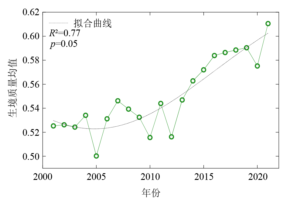
Figure 2 Inter-annual variation of mean ecosystem quality in Yunnan-Guangxi-Guizhou desertification area 2001 to 2021
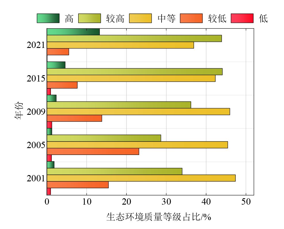
Figure 3 Percentage of ecological environment quality grades in Yunnan-Guangxi-Guizhou rocky desertification area in different years
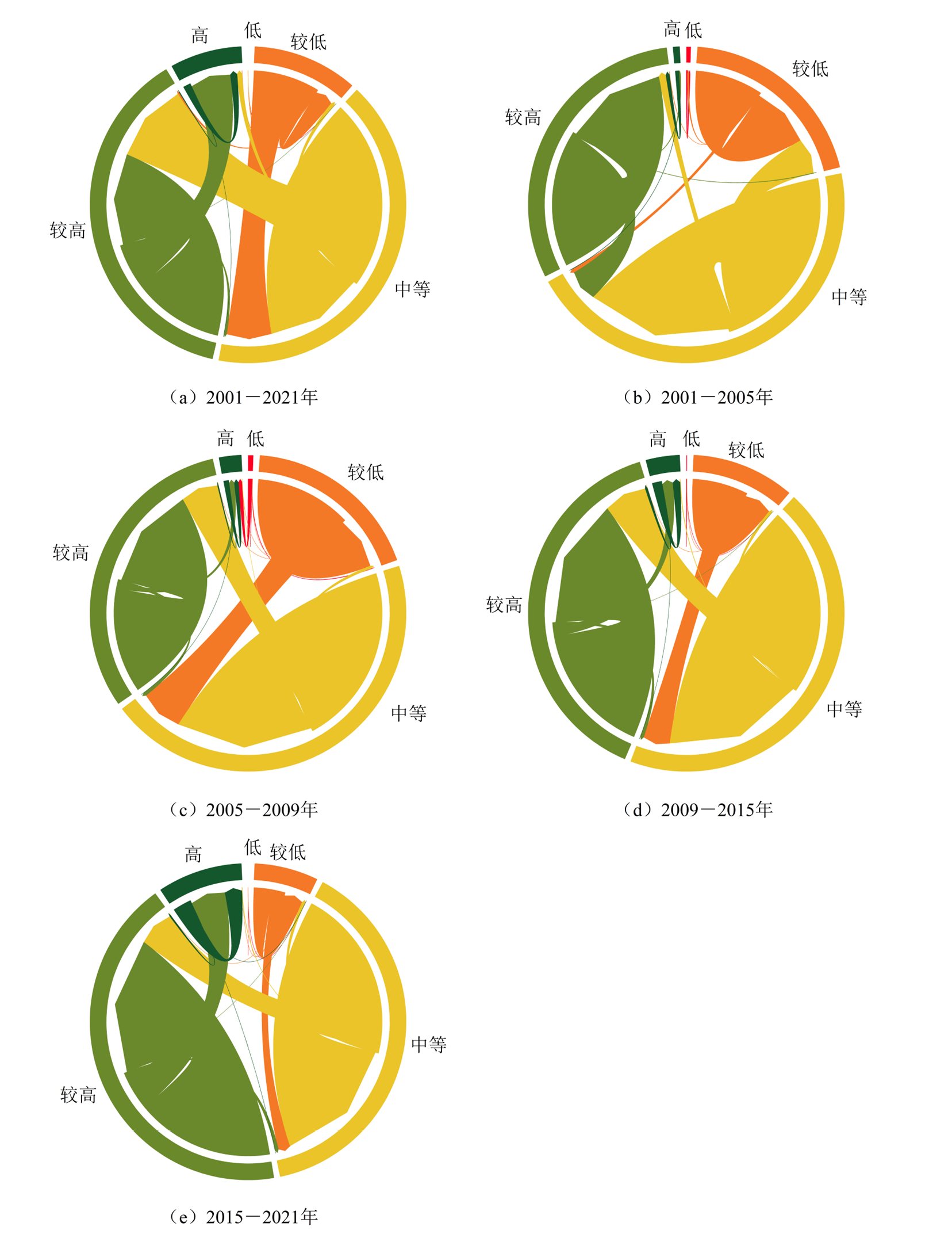
Figure 4 Shift of ecological environment quality level in Yunnan-Guangxi-Guizhou rocky desertification area

Figure 5 Spatial distribution pattern of habitat quality in the Yunnan-Guangxi-Guizhou desertification area from 2001 to 2021
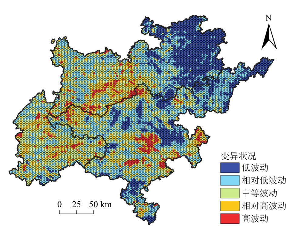
Figure 6 Spatial distribution of CV of ecological environment quality in the Yunnan-Guangxi-Guizhou rocky desertification area
| 趋势类型 | 变化趋势占比/% |
|---|---|
| 极显著下降 | 2.31 |
| 显著下降 | 1.51 |
| 微显著下降 | 0.86 |
| 不显著下降 | 7.11 |
| 无变化 | 0.34 |
| 不显著改善 | 14.68 |
| 微显著改善 | 4.17 |
| 显著改善 | 11.79 |
| 极显著改善 | 57.23 |
Table 5 The proportion of ecological environment quality change trend from 2001 to 2021
| 趋势类型 | 变化趋势占比/% |
|---|---|
| 极显著下降 | 2.31 |
| 显著下降 | 1.51 |
| 微显著下降 | 0.86 |
| 不显著下降 | 7.11 |
| 无变化 | 0.34 |
| 不显著改善 | 14.68 |
| 微显著改善 | 4.17 |
| 显著改善 | 11.79 |
| 极显著改善 | 57.23 |
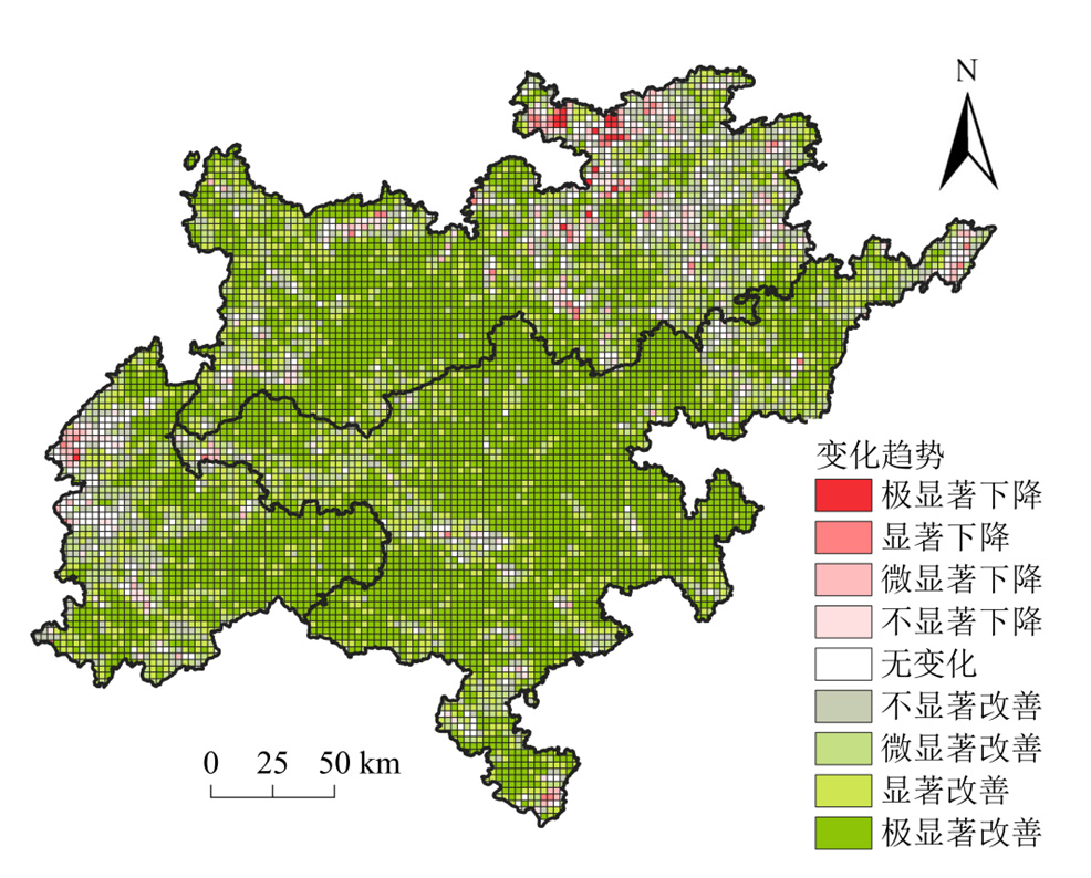
Figure 7 The change trend of ecological environment quality in the Yunnan-Guangxi-Guizhou rocky desertification area

Figure 8 Trend of future evolution of ecological environment quality in the Yunnan-Guangxi-Guizhou rocky desertification area
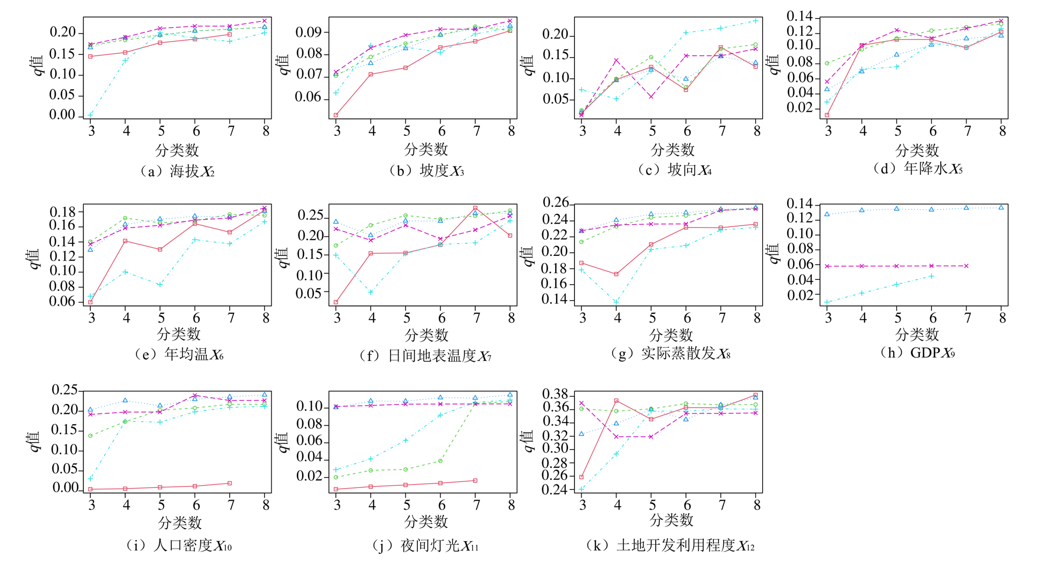
Figure 9 Spatial discrete optimization based on OPGD model
| 因素 | 生态环境质量单因子探测结果 | |||||
|---|---|---|---|---|---|---|
| 2001 | 2005 | 2009 | 2015 | 2021 | q均值 | |
| 土地覆被类型(X1) | 0.26 | 0.24 | 0.28 | 0.26 | 0.27 | 0.26 |
| 海拔(X2) | 0.22 | 0.23 | 0.24 | 0.23 | 0.23 | 0.23 |
| 坡度(X3) | 0.03 | 0.01 | 0.01 | 0.02 | 0.03 | 0.02 |
| 坡向(X4) | 0.03 | 0.01 | 0.02 | 0.01 | 0.01 | 0.02 |
| 年降水(X5) | 0.1 | 0.14 | 0.1 | 0.14 | 0.11 | 0.12 |
| 年均温(X6) | 0.04 | 0.01 | 0.03 | 0.08 | 0.07 | 0.05 |
| 日间地表温度(X7) | 0.41 | 0.43 | 0.32 | 0.34 | 0.28 | 0.36 |
| 实际蒸散发(X8) | 0.25 | 0.21 | 0.27 | 0.25 | 0.16 | 0.23 |
| GDP(X9) | 0.09 | 0.08 | 0.1 | 0.13 | 0.14 | 0.11 |
| 人口密度(X10) | 0.11 | 0.15 | 0.23 | 0.24 | 0.18 | 0.18 |
| 夜间灯光(X11) | 0.06 | 0.04 | 0.05 | 0.11 | 0.15 | 0.08 |
| 土地开发利用程度(X12) | 0.43 | 0.41 | 0.37 | 0.38 | 0.36 | 0.39 |
Table 6 Results of single factor detection of ecological and environmental quality from 2001 to 2021
| 因素 | 生态环境质量单因子探测结果 | |||||
|---|---|---|---|---|---|---|
| 2001 | 2005 | 2009 | 2015 | 2021 | q均值 | |
| 土地覆被类型(X1) | 0.26 | 0.24 | 0.28 | 0.26 | 0.27 | 0.26 |
| 海拔(X2) | 0.22 | 0.23 | 0.24 | 0.23 | 0.23 | 0.23 |
| 坡度(X3) | 0.03 | 0.01 | 0.01 | 0.02 | 0.03 | 0.02 |
| 坡向(X4) | 0.03 | 0.01 | 0.02 | 0.01 | 0.01 | 0.02 |
| 年降水(X5) | 0.1 | 0.14 | 0.1 | 0.14 | 0.11 | 0.12 |
| 年均温(X6) | 0.04 | 0.01 | 0.03 | 0.08 | 0.07 | 0.05 |
| 日间地表温度(X7) | 0.41 | 0.43 | 0.32 | 0.34 | 0.28 | 0.36 |
| 实际蒸散发(X8) | 0.25 | 0.21 | 0.27 | 0.25 | 0.16 | 0.23 |
| GDP(X9) | 0.09 | 0.08 | 0.1 | 0.13 | 0.14 | 0.11 |
| 人口密度(X10) | 0.11 | 0.15 | 0.23 | 0.24 | 0.18 | 0.18 |
| 夜间灯光(X11) | 0.06 | 0.04 | 0.05 | 0.11 | 0.15 | 0.08 |
| 土地开发利用程度(X12) | 0.43 | 0.41 | 0.37 | 0.38 | 0.36 | 0.39 |
| 判断依据 | 交互作用类型 |
|---|---|
| q(X1∩X2)<Min[q(X1), q(X2)] | 非线性减弱 |
| Min[q(X1), q(X2)]<q(X1∩X2)<Max[q(X1)+q(X2)] | 单因子非线性减弱 |
| q(X1∩X2)>Max[q(X1)q(X2)] | 双因子增强 |
| q(X1∩X2)>q(X1)+(X2) | 非线性增强 |
| q(X1∩X2)=q(X1)+(X2) | 独立 |
Table 7 Types of interactions
| 判断依据 | 交互作用类型 |
|---|---|
| q(X1∩X2)<Min[q(X1), q(X2)] | 非线性减弱 |
| Min[q(X1), q(X2)]<q(X1∩X2)<Max[q(X1)+q(X2)] | 单因子非线性减弱 |
| q(X1∩X2)>Max[q(X1)q(X2)] | 双因子增强 |
| q(X1∩X2)>q(X1)+(X2) | 非线性增强 |
| q(X1∩X2)=q(X1)+(X2) | 独立 |

Figure 10 Results of interactive detection
| 驱动因子 | 适宜的范围或类型 | q值 |
|---|---|---|
| 土地覆被类型(X1) | 森林、灌木 | 0.63 |
| 海拔(X2) | 442-673 m | 0.65 |
| 坡度(X3) | 27.5°-33.3° | 0.62 |
| 坡向(X4) | 1.09°-3.36° | 0.62 |
| 年降水量(X5) | 2850-3000 mm | 0.63 |
| 年均温(X6) | 26.1-27.3 ℃ | 0.66 |
| 日间地表温度(X7) | 25.3-28.7 ℃ | 0.59 |
| 实际蒸散发(X8) | 1440-1980 mm | 0.68 |
| GDP(X9) | 0-789 yuan·km−2 | 0.61 |
| 人口密度(X10) | 39.8-71.3 person·km−2 | 0.67 |
| 夜间灯光(X11) | 0-0.46 | 0.61 |
| 土地开发利用程度(X12) | 204-212 | 0.68 |
Table 8 Appropriate range or type for each factor
| 驱动因子 | 适宜的范围或类型 | q值 |
|---|---|---|
| 土地覆被类型(X1) | 森林、灌木 | 0.63 |
| 海拔(X2) | 442-673 m | 0.65 |
| 坡度(X3) | 27.5°-33.3° | 0.62 |
| 坡向(X4) | 1.09°-3.36° | 0.62 |
| 年降水量(X5) | 2850-3000 mm | 0.63 |
| 年均温(X6) | 26.1-27.3 ℃ | 0.66 |
| 日间地表温度(X7) | 25.3-28.7 ℃ | 0.59 |
| 实际蒸散发(X8) | 1440-1980 mm | 0.68 |
| GDP(X9) | 0-789 yuan·km−2 | 0.61 |
| 人口密度(X10) | 39.8-71.3 person·km−2 | 0.67 |
| 夜间灯光(X11) | 0-0.46 | 0.61 |
| 土地开发利用程度(X12) | 204-212 | 0.68 |
| [1] | GAO W D, ZHENG C, LIU X H, et al., 2022. NDVI-based vegetation dynamics and their responses to climate change and human activities from 1982 to 2020: A case study in the Mu Us Sandy land, China[J]. Ecological Indicators, 137: 108745. |
| [2] | JOHN R, CHEN J, LU N, 2008. Predicting plant diversity based on remote sensing products in the semiarid region of Inner Mongolia[J]. Remote Sensing of Environment, 112(5): 2018-2032. |
| [3] | KENTEVEN G L, 1946. The coefficient of variation[J]. Nature, 158(4015): 520-521. |
| [4] | SONG Y Z, WANG J F, GE Y, 2020. An optimal parameters-based geo-graphical detector model enhances geographic characteristics of explanatory variables for spatial heterogeneity analysis: Cases with different types of spatial data[J]. GIScience & Remote Sensing, 57(5): 593-610. |
| [5] | WANG Y F, SHEN J Y, CHEN Y N, 2012. Vegetation dynamics and their response to hydroclimatic factors in the Tarim River Basin[J]. Ecohydrology, 6(6): 4267-4283. |
| [6] | XU D, YANG F, YU L, 2021. Quantization of the coupling mechanism between eco-environmental quality and urbanization from multisource remote sensing data[J]. Journal of Cleaner Production, 321: 128948. |
| [7] |
陈慧琳, 2000. 南方岩溶区人地系统的基本地域分异探讨[J]. 地理研究, 19(1): 73-79.
DOI |
| CHEN H L, 2000. A study on basic territorial differences in the man-land system in karst regions of South China[J]. Geographical Research, 19(1): 73-79. | |
| [8] | 陈莉, 2015. 基于PCA-GASVM的晋陕甘宁地区生态环境评价[J]. 干旱区地理, 38(6): 1262-1269. |
| CHEN L, 2015. Evaluation of the ecology and environment of Shanxi-Shaanxi-GansuNingxia area based on PCA-GA-SVM[J]. Arid Land Geography, 38(6): 1262-1269. | |
| [9] | 陈全, 2014. 典型石漠化地区生态环境质量动态评价及其对人为干预的响应——以花江示范区为例[D]. 贵阳: 贵州师范大学. |
| CHEN Q, 2014. Dynamic eco-environmental quality assessment and its response to human intervention in typical rocky desertification area: A case study in Huajiang area[D]. Guiyang: Guizhou Normal University. | |
| [10] | 陈宜欣, 宁晓刚, 张翰超, 等, 2024. 遥感生态指数 (RSEI) 模型及应用综述[J]. 自然资源遥感, 36(3): 28-40. |
| CHEN Y X, NING X G, ZHANG H C, et al., 2024. Remote sensing ecological index (RSEI) model and its applications: A review[J]. Remote Sensing for Natural Resources, 36(3): 28-40. | |
| [11] | 但新球, 白建华, 吴协保, 等, 2015. 石漠化综合治理二期工程总体思路研究[J]. 中南林业调查规划, 34(3): 62-66. |
| DAN X Q, BAI J H, WU X B, et al., 2015. Research on the general idea of the second phase of the rocky desertification comprehensive treatment project[J]. Central South Forest Inventory and Planning, 34(3): 62-66. | |
| [12] | 凡非得, 王克林, 宣勇, 等, 2011. 西南喀斯特区域生态环境敏感性评价及其空间分布[J]. 长江流域资源与环境, 20(11): 1394-1399. |
| FAN F D, WANG K L, XUAN Y, et al., 2011. Eco-environmental sensitivity and its spatial distribution in karst regions, Southwest China[J]. Resources and Environment in the Yangtze Basin, 20(11): 1394-1399. | |
| [13] | 范金明, 张超, 钱慧, 等, 2024a. 云南生态环境质量演变过程及驱动力分析[J]. 西南林业大学学报(自然科学), 44(5): 74-81. |
| FAN J M, ZHANG C, QIAN H, et al., 2024a. Analysis on the evolution process of ecological environment quality and driving force of Yunnan[J]. Journal of Southwest Forestry University (Natural Sciences), 44(5): 74-81. | |
| [14] | 范金明, 张超, 钱慧, 等, 2024b. 岩溶石漠化地区生态环境演变及驱动力分析[J]. 森林与环境学报, 44(3): 298-307. |
| FAN J M, ZHANG C, QIAN H, et al., 2024b. Analysis of ecological environment evolution and driving forces in a karst rocky desertification area[J]. Journal of Forest and Environment, 44(3): 298-307. | |
| [15] | 傅楷翔, 贾国栋, 余新晓, 等, 2024. 基于改进遥感生态指数的吐鲁番-哈密地区生态环境质量评价及驱动机制分析[J]. 生态学报, 44(9): 3911-3923. |
| FU K X, JIA G D, YU X X, et al., 2024. Evaluation of ecological environment quality and analysis of driving mechanism in Tulufan-Hami region based on improved remote sensing ecological indices[J]. Acta Ecologica Sinica, 44(9): 3911-3923. | |
| [16] |
付绍桐, 贺晨曦, 马佳凯, 等, 2024. 不同发展情景下黄河流域山西段生态环境质量[J]. 应用生态学报, 35(5): 1337-1346.
DOI |
| FU S T, HE C X, MA J K, et al., 2024. Ecological environment quality of the Shanxi section of the Yellow River[J]. Chinese Journal of Applied Ecology, 35(5): 1337-1346. | |
| [17] | 胡宝清, 金妹兰, 曹少英, 等, 2004. 基于GIS技术的广西喀斯特生态环境脆弱性综合评价分析[J]. 水土保持学报, 18(1): 103-107. |
| HU B Q, JIN M L, CAO S Y, et al., 2004. Comprehensive evaluation of fragile karst eco-environment in Guangxi Zhuang Autonomous Region based on GIS[J]. Journal of Soil and Water Conservation, 18(1): 103-107. | |
| [18] | 胡李发, 谢元礼, 崔思颖, 等, 2021. 关中平原城市群夏季城市热岛特征及驱动力[J]. 中国环境科学, 41(8): 3842-3852. |
| HU L F, XIE Y L, CUI S Y, et al., 2021. The characteristics and driving forces of summer urban heat island in Guanzhong plain urban agglomeration[J]. China Environmental Science, 41(8): 3842-3852. | |
| [19] | 黄丽芳, 覃星铭, 胡宝清, 等, 2023. 近20年桂西南生态系统健康时空变化及其驱动因素分析[J]. 广西科学院学报, 39(3): 268-279. |
| HUANG L F, QIN X M, HU B Q, et al., 2023. Analysis of spatial and temporal changes in ecosystem health and its drivers in Southwest Guangxi in the last 20 years[J]. Journal of Guangxi Academy of Sciences, 36(3): 268-279. | |
| [20] | 黄天能, 张云兰, 2021. 基于 “三生空间” 的土地利用功能演变及生态环境响应——以桂西资源富集区为例[J]. 生态学报, 41(1): 348-359. |
| HUANG T N, ZHANG Y L, 2021. Transformation of land use function and response of eco-environment based on “production-life-ecology space”: A case study of resource-rich area in Western Guangxi[J]. Acta Ecologica Sinica, 41(1): 348-359. | |
| [21] | 蒋明明, 刘佳, 侯伟, 等, 2022. 一种改进的遥感生态指数构建及湿地监测应用[J]. 测绘科学, 47(7): 85-92. |
| JIANG M M, LIU J, HOU W, et al., 2022. An improved remote sensing-based ecological index and its application in wetland environment monitoring[J]. Science of Surveying and Mapping, 47(7): 85-92. | |
| [22] | 柯奇画, 张科利, 王爱娟, 等, 2021. 喀斯特石漠化生态治理技术集成及其多尺度综合配置[J]. 水土保持通报, 41(6): 237-248. |
| KE Q H, ZHANG K L, WANG A J, et al., 2021. Database construction and multi-scale integrated arrangement of eco-technology for combating karst rocky desertification[J]. Bulletin of Soil and Water Conservation, 41(6): 237-248. | |
| [23] |
李文艳, 兰安军, 范泽孟, 等, 2024. 黔中城市生态功能区生态环境质量动态评估及其驱动因素分析[J]. 地球物理学进展, 39(5): 1749-1762.
DOI |
|
LI W Y, LAN A J, FAN Z M, et al., 2024. Dynamic assessment of ecological environment quality in the ecological functional zone of central Guizhou City and its driving factor analysis[J]. Progress in Geophysics, 39(5): 1749-1762.
DOI |
|
| [24] | 李泽红, 柏永青, 孙九林, 2019. 西部生态脆弱贫困区生态文明建设战略研究[J]. 中国工程科学, 25(5): 80-86. |
|
LI Z H, BAI Y Q, SUN J L, 2019. Ecological civilization construction in ecologically fragile poverty-stricken areas in Western China[J]. Strategic Study of CAE, 21(5): 80-86.
DOI |
|
| [25] | 刘炜, 焦树林, 2022. 喀斯特流域极端气候变化特征及对NDVI的影响[J]. 水土保持学报, 36(5): 220-232. |
| LIU W, JIAO S L, 2022. Characteristics of extreme climate change in karst basin and its impact on NDVI[J]. Journal of Soil and Water Conservation, 36(5): 220-232. | |
| [26] |
马炳鑫, 和彩霞, 靖娟利, 等, 2023. 1982-2019年中国西南地区植被变化归因研究[J]. 地理学报, 78(3): 714-728.
DOI |
|
MA B X, HE C X, JING J L, et al., 2023. Attribution of vegetation dynamics in Southwest China from 1982 to 2019[J]. Acta Geographica Sinica, 78(3): 714-728.
DOI |
|
| [27] |
马士彬, 安裕伦, 杨广斌, 2016. 喀斯特地区不同植被类型NDVI变化及驱动因素分析——以贵州为例[J]. 生态环境学报, 25(7): 1106-1114.
DOI |
| MA S B, AN Y L, YANG G B, 2016. The analysis of the difference vegetation variation and driver factors on NDVI change in karst region: A case on Guizhou[J]. Ecology and Environmental Sciences, 25(7): 1106-1114. | |
| [28] | 农兰萍, 王金亮, 玉院和, 2021. 基于改进型遥感生态指数 (MRSEI) 模型的滇中地区生态环境质量研究[J]. 生态与农村环境学报, 37(8): 972-982. |
| NONG L P, WANG J L, YU Y H, 2021. Research on ecological environment quality in central Yunnan based on MRSEI model[J]. Journal of Ecology and Rural Environment, 37(8): 972-982 | |
| [29] | 沈文婕, 康宇杰, 张晓凡, 等, 2024. 大熊猫国家公园四川片区植被时空变化及其地形分异[J]. 生态学报, 44(20): 9081-9093. |
| SHEN W J, KANG Y J, ZHANG X F, et al., 2024. Spatio-temporal variation of vegetation and its topographic differentiation in the Sichuan area of Giant Panda National Park[J]. Acta Ecologica Sinica, 44(20): 9081-9093. | |
| [30] | 宋刚勇, 周创兵, 傅少君, 等, 2023. 基于SPEI指数的重庆干旱特征分析与预测模型构建[J]. 武汉大学学报(工学版), 56(12): 1458-1471. |
| SONG G Y, ZHOU C B, FU S J, et al., 2023. Analysis of drought characteristics and construction of prediction model in Chongqing based on SPEI index[J]. Engineering Journal of Wuhan University, 56(12): 1458-1471. | |
| [31] |
王嘉丽, 冯婧珂, 杨元征, 等, 2023. 南宁市主城区不透水面与热环境效应的空间关系研究[J]. 生态环境学报, 32(3): 525-534.
DOI |
| WANG J L, FENG J K, YANG Y Z, et al., 2023. Research on spatial relations between impervious surfaces and the urban thermal environment in the central metropolitan area of Nanning City[J]. Ecology and Environmental Sciences, 32(3): 525-534. | |
| [32] | 王世杰, 2002. 喀斯特石漠化概念演绎及其科学内涵的探讨[J]. 中国岩溶, 21(2): 31-35. |
| WANG S J, 2002. Concept deduction and its connotation of karst rocky desertification[J]. Carsologica Sinica, 21(2): 31-35. | |
| [33] | 王颂吉, 2024. 进一步推动西部大开发形成新格局: 进展与动力[J]. 改革 (8): 88-97. |
| WANG S J, 2024. Further promoting the formation of a new pattern in the Western development: Progress and driving force[J]. Reform (8): 88-97. | |
| [34] | 王永锋, 靖娟利, 刘海红, 等, 2024. 顾及时滞和累积效应的西南喀斯特地区植被变化归因分析[J/OL]. 环境科学, 1-14[2025-03-17]. https://doi.org/10.13227/j.hjkx.202406168. |
| WANG Y F, JING J L, LIU H H, et al., 2024. Attribution analysis of vegetation variation in the karst region of Southwest China considering time lag and accumulation effects[J/OL]. Environmental Science, 1-14[2025-03-17]. https://doi.org/10.13227/j.hjkx.202406168. | |
| [35] | 魏慧, 赵文武, 张骁, 等, 2017. 基于土地利用变化的区域生态系统服务价值评价——以山东省德州市为例[J]. 生态学报, 37(11): 3830-3839. |
| WEI H, ZHAO W W, ZHANG X, et al., 2017. Regional ecosystem service value evaluation based on land use changes: A case study in Dezhou, Shandong Provience, China[J]. Acta Ecologica Sinica, 37(11): 3830-3839. | |
| [36] | 武爱彬, 程林, 赵艳霞, 2024. 快速城镇化地区生态环境质量时空格局演变及对土地利用变化响应——以廊坊市北三县为例[J]. 西北林学院学报, 39(1): 169-176. |
| WU A B, CHENG L, ZHAO Y X, 2024. Spatial-temporal pattern evolution of eco-environmental quality and its response to land use change in rapidly urbanized areas: A case study of Northern three counties in Langfang City[J]. Journal of Northwest Forestry University, 39(1): 169-176. | |
| [37] | 吴艳霞, 刘方南, 陈宝童, 2023. 黄河流域下游城市群生境质量时空演变及其驱动因素[J]. 水土保持通报, 43(4): 396-404. |
| WU Y X, LIU F N, CHEN B T, 2023. Spatial and temporal evolution and drivers of habitat quality of urban agglomeration in Lower Yellow River Basin[J]. Bulletin of Soil and Water Conservation, 43(4): 396-404. | |
| [38] | 熊康宁, 池永宽, 2015. 中国南方喀斯特生态系统面临的问题及对策[J]. 生态经济, 31(1): 23-30. |
| XIONG K N, CHI Y K, 2015. The problems in Southern China karst ecosystem in Southern of China and its countermeasures[J]. Ecological Economy, 31(1): 23-30. | |
| [39] | 徐涵秋, 2013. 区域生态环境变化的遥感评价指数[J]. 中国环境科学, 33(5): 889-897. |
| XU H Q, 2013. A remote sensing index for assessment of regional ecological changes[J]. China Environmental Science, 33(5): 889-897. | |
| [40] | 徐世英, 李京洮, 2023. 我国少数民族人口数量及分布的新态势——基于第七次全国人口普查数据的解析[J]. 人口与经济 (3): 1-19. |
| XU S Y, LI J T, 2023. The new situation of the number and distribution for ethnic minority population in China: Analysis based on the seventh national census bulletin[J]. Population & Economics (3): 1-19. | |
| [41] | 徐勇, 黄雯婷, 窦世卿, 等, 2022. 2000-2020年西南地区植被NDVI对气候变化和人类活动响应特征[J]. 环境科学, 43(6): 3230-3240. |
| XU Y, HUANG W T, DOU S Q, et al., 2022. Responding mechanism of vegetation cover to climate change and human activities in Southwest China from 2000 to 2020[J]. Environmental Science, 43(6): 3230-3240. | |
| [42] | 许幼霞, 周旭, 赵翠薇, 等, 2017. 1990-2015年间贵州省植被生态环境质量变化特征[J]. 地球与环境, 45(4): 434-440. |
| XU Y X, ZHOU X, ZHAO C W, et al., 2017. Analysis of vegetation eco-environment quality change features in Guizhou Province from 1990 to 2015[J]. Earth and Environment, 45(4): 434-440. | |
| [43] | 颜梅春, 王元超, 2012. 区域生态环境质量评价研究进展与展望[J]. 生态环境学报, 21(10): 1781-1788. |
| YAN M C, WANG Y C, 2012. Advances in the evaluation of ecological environmental quality[J]. Ecology and Environmental Sciences, 21(10): 1781-1788. | |
| [44] | 杨军昌, 吴青芬, 李绍练, 2019. 基于生态足迹的滇桂黔石漠化片区人口与环境——以黔西南州为分析对象[J]. 生态经济, 35(10): 136-142, 190. |
| YANG J C, WU Q F, LI S L, 2019. Ecological footprint in the karst rocky desertification area of Yunnan, Guangxi and Guizhou: A case analysis of Guizhou Southwest Autonomous Prefecture[J]. Ecological Economy, 35(10): 136-142, 190. | |
| [45] | 杨馗, 信桂新, 蒋好雨, 等, 2021. 基于最佳尺度的景观生态风险时空变化研究: 以重庆市江津区为例[J]. 生态与农村环境学报, 37(5): 576-586. |
| YANG K, XIN G X, JIANG H Y, et al., 2021. Study on spatiotemporal changes of landscape ecological risk based on the optimal spatial scale: A case study of Jiangjin District, Chongqing City[J]. Journal of Ecology and Rural Environment, 37(5): 576-586. | |
| [46] | 杨明德, 梁虹, 2000. 峰丛洼地形成动力过程与水资源开发利用[J]. 中国岩溶, 19(1): 46-53. |
| YANG M D, LIANG H, 2000. The processes of evolution dynamic of cone karst and the exploitation of the water resource[J]. Carsologica Sinica, 19(1): 46-53. | |
| [47] | 杨士友, 2003. 喀斯特山区生态地质环境评价方法探讨[J]. 贵州地质, 20(2): 68-72. |
| YANG S Y, 2003. Assessment of the bio-geo environment in the karst mountainous areas[J]. Guizhou Geology, 20(2): 68-72. | |
| [48] | 叶宗达, 许进龙, 黄天能, 等, 2023. 滇桂黔石漠化片区土地生态系统服务价值时空演变研究[J]. 科学技术与工程, 23(26): 11136-11144. |
| YE Z D, XU J L, HUANG T N, et al., 2023. Spatial and temporal evolution of land ecosystem service value in the rocky desertification area of Yunnan, Guangxi and Guizhou[J]. Science Technology and Engineering, 23(26): 11136-11144. | |
| [49] | 余梦, 李阳兵, 罗光杰, 2022. 中国西南岩溶山地石漠化演变趋势[J]. 生态学报, 42(10): 4267-4283. |
| YU M, LI Y B, LUO G J, 2022. Evolution trend of rocky desertification in karst mountains in Southwest China[J]. Acta Ecologica Sinica, 42(10): 4267-4283. | |
| [50] | 袁丽华, 蒋卫国, 申文明, 等, 2013. 2000-2010年黄河流域植被覆盖的时空变化[J]. 生态学报, 33(24): 7798-7806. |
| YUAN L H, JIANG W G, SHEN W M, et al., 2013. The spatio-temporal variations of vegetation cover in the Yellow River Basin from 2000 to 2010[J]. Acta Ecologica Sinica, 33(24): 7798-7806. | |
| [51] | 张鹄志, 马传明, 王江思, 2014. 基于层次分析-熵权法的中原城市群生态环境评价[J]. 安全与环境工程, 21(1): 87-92. |
| ZHANG H Z, MA C M, WANG J S, 2014. Eco-environment condition assessment of urban agglomeration in the central plain based on AHP-entropy method[J]. Safety and Environmental Engineering, 21(1): 87-92. | |
| [52] | 张诗文, 李成荣, 王妍, 等, 2023. 基于长时序卫星遥感的云南省生态质量评价与演变特征[J]. 浙江农林大学学报, 40(3): 579-588. |
| ZHANG S W, LI C R, WANG Y, et al., 2023. Evaluation and evolution characteristics of ecological quality in Yunnan based on long-time series satellite remote sensing[J]. Journal of Zhejiang A & F University, 40(3): 579-588. | |
| [53] |
张学儒, 周杰, 李梦梅, 2020. 基于土地利用格局重建的区域生境质量时空变化分析[J]. 地理学报, 75(1): 160-178.
DOI |
|
ZHANG X R, ZHOU J, LI M M, 2020. Analysis on spatial and temporal changes of regional habitat quality based on the spatial pattern reconstruction of land use[J]. Acta Geographica Sinica, 75(1): 160-178.
DOI |
|
| [54] | 张亚丽, 黄柱军, 田义超, 等, 2024. 桂西南喀斯特峰丛洼地流域生境质量时空变化及驱动机制[J]. 生态与农村环境学报, 40(7): 877-887. |
| ZHANG Y L, HUANG Z J, TIAN Y C, et al., 2024. Spatio-temporal evolution characteristics and driving mechanism of habitat quality in the karst peak cluster depression basin of Southwestern Guangxi[J]. Journal of Ecology and Rural Environment, 40(7): 877-887. | |
| [55] | 庄大方, 刘纪远, 1997. 中国土地利用程度的区域分异模型研究[J]. 自然资源学报, 12(2): 10-16. |
| ZHUANG D F, LIU J Y, 1997. Study on the model of regional differentiation of land use degree in China[J]. Journal of Natural Resources, 12(2): 10-16. | |
| [56] | 左璐, 孙雷刚, 徐全洪, 等, 2021. 区域生态环境评价研究综述[J]. 云南大学学报(自然科学版), 43(4): 806-817. |
| ZUO L, SUN L G, XU Q H, et al., 2021. A review of the studies on regional ecological environment evaluation[J]. Journal of Yunnan University (Natural Sciences Edition), 43(4): 806-817. |
| [1] | JIANG Ruixia, WANG Zhengxin, SUN Fangfang, DONG Chengcheng, ZHAO Longlong, LI Xiaoli, CHEN Jinsong, LI Hongzhong, WANG Li. Analysis of the Spatiotemporal Evolution Pattern of Shenzhen’s Ecological Quality Based on the Unified Remote Sensing Ecological Index [J]. Ecology and Environmental Sciences, 2025, 34(5): 796-806. |
| [2] | SHEN Jialong, WU Lihong, LI Linshuang, ZHOU Yuanfang, YANG Xiaomin. Effects of Land Uses on Soil Organic Carbon Fractions and Their Carbon Sequestration in a Typical Karst Small Mountain Watershed [J]. Ecology and Environmental Sciences, 2025, 34(3): 358-367. |
| [3] | LI Jianfu, HUANG Zhilin, HE Chengzhong, JIANG Xin, SONG Lin, LIU Jiaxin, CHEN Liding. Spatial Distribution and Key Factors Affecting Soil Organic Carbon Within the Karst Fault Basin in Eastern Yunnan, China [J]. Ecology and Environmental Sciences, 2024, 33(9): 1339-1352. |
| [4] | SONG Xiaolong, MA Mingde, WANG Peng, LI Longtang, MI Wenbao, SONG Yongyong. The Spatiotemporal Non-stationary Characteristics of Fractional Vegetation Coverage During the Growing Season of Different Geographical Regions in Ningxia [J]. Ecology and Environmental Sciences, 2024, 33(6): 853-868. |
| [5] | HE Muquan, SHI Yanjun, WANG Chenxi, LUO Zuhong, ZHANG Shaotong. Spatiotemporal Distribution Characteristics of Vegetation Ecology and Its Meteorological Contribution in Guangdong Province [J]. Ecology and Environmental Sciences, 2024, 33(5): 679-688. |
| [6] | LU Ankang, ZHAO Guanhua, WANG Hui, ZHOU Lijian, TANG Shengqun, PENG Zhilong. Application and Research Development of Radioisotope 14C Dating in Karst Groundwater [J]. Ecology and Environmental Sciences, 2024, 33(3): 487-498. |
| [7] | LIANG Yan, LIU Jiaqi, XIAO Fan, PAN Minping, WEI Kaiwen, ZHANG Chuwen, DUAN Min. Effects of Nitrogen Deposition Forms on Sources of Soil Available Phosphorus in Karst Forest of Southwest China [J]. Ecology and Environmental Sciences, 2024, 33(2): 192-201. |
| [8] | LI Qiang, TANG Qing, WU Rui. Influence of Antibiotic Addition on Priming Effect of Soil Organic Matter from Different Successional Stages in Karst Ecosystems [J]. Ecology and Environmental Sciences, 2024, 33(11): 1717-1726. |
| [9] | LI Zikang, YIN Xiaojie, LIU Yifei, TANG Jimin, WANG Yan. Spatio-temporal Evolution and Ecological Sensitivity Evaluation of Rocky Desertification in Typical Karst Mountainous Areas of Southeast Yunnan Province [J]. Ecology and Environmental Sciences, 2024, 33(11): 1792-1802. |
| [10] | CHEN Yan, YANG Hui, NING Jing, ZHU Degen, WU Xia, HUANG Fen, MA Yang, CHEN Wei, Mitja PRELOVŠEK, Nataša RAVBAR. Plant Water Use Sources and Efficiency During Vegetation Restoration in Typical Karst Area Under Severe Drought Conditions [J]. Ecology and Environmental Sciences, 2024, 33(10): 1534-1543. |
| [11] | FENG Zixian, SHE Lu, WANGXiuhui , YANG Lu, YANG Chen. Spatial and Temporal Variations of Ecological Environment Quality in Ningxia Based on Improved Remote Sensing Ecological Index [J]. Ecology and Environmental Sciences, 2024, 33(1): 131-143. |
| [12] | XU Zijin, ZHANG Xuesong, CHEN Mingman. Analysis of Spatiotemporal Evolution Characteristics of Ecosystem Services in Mountainous Karst Areas: A Case Study of Guizhou Province, China [J]. Ecology and Environmental Sciences, 2023, 32(7): 1196-1206. |
| [13] | DU Jiaoyan, CAI Guojun, ZHANG Hongyu, LI Anding. Response of Plant Leaf C, N, P Stoichiometry Characteristics to Climatic Environment and Soil Nutrients in Karst Areas of Guizhou [J]. Ecology and Environmental Sciences, 2023, 32(12): 2154-2165. |
| [14] | ZHANG Lijin, DU Hu, ZENG Fuping, HUANG Guoqin, SONG Min, SONG Tongqing. Discussion on the Relationship between Productivity and Diversity during Vegetation Restoration in the Karst Peak-cluster Depression [J]. Ecology and Environmental Sciences, 2023, 32(1): 26-35. |
| [15] | RUAN Huihua, XU Jianhui, ZHANG Feifei. Spatiotemporal Changes of Vegetation and Land Surface Temperature during 2001 and 2020 in the Guangdong-Hong Kong-Macao Greater Bay Area of China [J]. Ecology and Environmental Sciences, 2022, 31(8): 1510-1520. |
| Viewed | ||||||
|
Full text |
|
|||||
|
Abstract |
|
|||||
Copyright © 2021 Editorial Office of ACTA PETROLEI SINICA
Address:No. 6 Liupukang Street, Xicheng District, Beijing, P.R.China, 510650
Tel: 86-010-62067128, 86-010-62067137, 86-010-62067139
Fax: 86-10-62067130
Email: syxb@cnpc.com.cn
Support byBeijing Magtech Co.ltd, E-mail:support@magtech.com.cn