生态环境学报 ›› 2025, Vol. 34 ›› Issue (1): 13-25.DOI: 10.16258/j.cnki.1674-5906.2025.01.003
孙云堃1,2,3( ), 冯琦1,4, 丁长虹5, 温兆飞2,*()
收稿日期:2024-04-26
出版日期:2025-01-18
发布日期:2025-01-21
通讯作者:
* 温兆飞。E-mail: wenzhaofei@cigit.ac.cn作者简介:孙云堃(1999年生),男,硕士研究生,主要从事环境监测与环境系统分析。E-mail: sunyunkun@cigit.ac.cn
基金资助:
SUN Yunkun1,2,3(), FENG Qi1,4, DING Changhong5, WEN Zhaofei2,*()
Received:2024-04-26
Online:2025-01-18
Published:2025-01-21
摘要:
三峡水库消落区是指坝前水位175 m逐步消退至防洪限制水位145 m之间,水库两岸因水库调度运用出现的临时性淹没或出露的水陆交错区域。三峡水库运行已近20年,但消落区生态系统服务功能至今尚未被全面定量地认识,给消落区的管理保护和利用带来了诸多困扰。通过2021—2022年4次大范围高密度的消落区实地调查采样,共获得2000余份一手调查数据,并以此从消落区的支持功能、供给功能、调节功能和文化功能方面,系统地定量刻画了消落区生态系统服务功能。研究发现:1)三峡水库消落区生态系统的调节功能在空间上分布相对均匀,各个区县的得分在平均分0.67上下波动;2)从库首到库尾,三峡水库消落区生态系统的文化功能得分由0.60持续上升到0.73,呈现出持续上升的趋势;3)从库首到库尾,三峡水库消落区支持功能得分分别为0.34、0.41、0.27,供给功能得分分别为0.32、0.52、0.36,调节功能得分分别为0.55、0.72、0.67,服务功能指数分别为0.49、0.62、0.56,均呈现出先升高后降低的趋势;4)消落区生态系统服务功能在空间上呈现出集群分布特征。进一步分析了形成这种空间分布格局的可能原因,提出了针对性的生态保护和管理对策。
中图分类号:
孙云堃, 冯琦, 丁长虹, 温兆飞. 三峡水库消落区生态系统服务功能变化格局研究[J]. 生态环境学报, 2025, 34(1): 13-25.
SUN Yunkun, FENG Qi, DING Changhong, WEN Zhaofei. Study on the Change Pattern of Ecosystem Service Functions in the Water-level-Fluctuation Zone of the Three Gorges Reservoir[J]. Ecology and Environment, 2025, 34(1): 13-25.
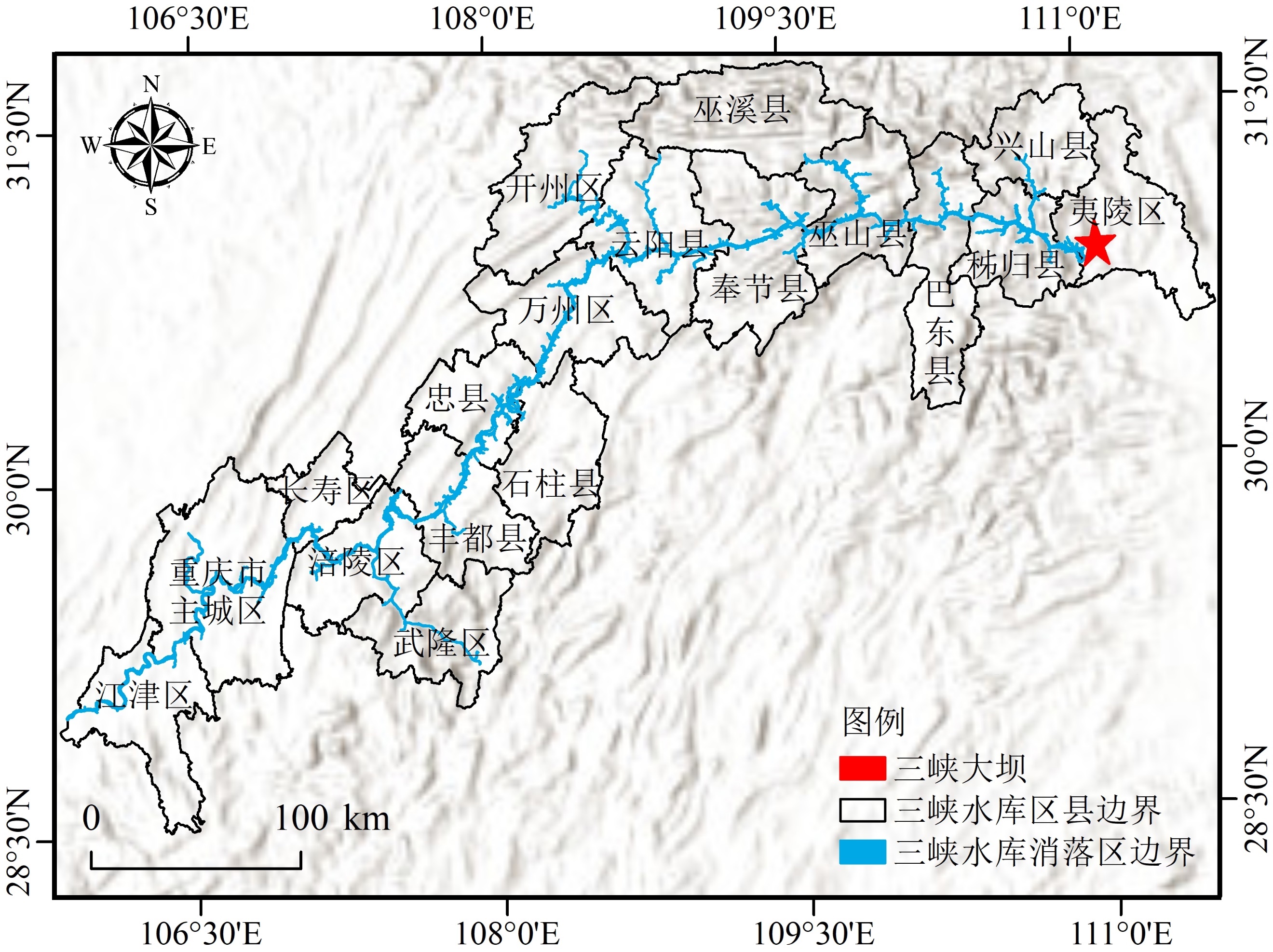
图1 三峡水库消落区边界示意图
Figure 1 Schematic Diagram of the Boundary of the water-level-fluctuation zone of the Three Gorges Reservoir
| 服务功能 | 供给功能 | 调节功能 | 支持功能 | 文化功能 |
|---|---|---|---|---|
| 表征指标 | NPP | 植被覆盖度 | 生物多样性 | 景观得分 |
| 土壤有机质含量 |
表1 三峡水库消落区生态系统服务功能分类
Table 1 Classification of ecosystem service functions in the Three Gorges Reservoir water-level-fluctuation zone
| 服务功能 | 供给功能 | 调节功能 | 支持功能 | 文化功能 |
|---|---|---|---|---|
| 表征指标 | NPP | 植被覆盖度 | 生物多样性 | 景观得分 |
| 土壤有机质含量 |

图2 三峡水库消落区生态系统服务功能指标数据采集点位分布
Figure 2 Distribution of service function data collection points in the Three Gorges Reservoir water-level-fluctuation zone
| 目标层 | 权重 | 准则层 | 权重 | 指标层 | 权重 |
|---|---|---|---|---|---|
| 三峡水库消落区生态系统服务功能评估 | 1.00 | 供给功能 | 0.19 | NPP | 0.19 |
| 调节功能 | 0.36 | 植被覆盖度 | 0.09 | ||
| 土壤有机质含量 | 0.27 | ||||
| 支持功能 | 0.15 | 生物多样性 | 0.15 | ||
| 文化功能 | 0.30 | 文化旅游得分 | 0.30 |
表2 三峡水库消落区生态系统服务功能各指标权重
Table 2 Weights of each indicator of ecosystem service function in the Three Gorges Reservoir water-level-fluctuation zone
| 目标层 | 权重 | 准则层 | 权重 | 指标层 | 权重 |
|---|---|---|---|---|---|
| 三峡水库消落区生态系统服务功能评估 | 1.00 | 供给功能 | 0.19 | NPP | 0.19 |
| 调节功能 | 0.36 | 植被覆盖度 | 0.09 | ||
| 土壤有机质含量 | 0.27 | ||||
| 支持功能 | 0.15 | 生物多样性 | 0.15 | ||
| 文化功能 | 0.30 | 文化旅游得分 | 0.30 |
| 服务功能等级 | 服务功能水平 |
|---|---|
| 一级(≥0.62) | 较好 |
| 二级 [0.57, 0.62) | 好 |
| 三级 [0.52, 0.57) | 良好 |
| 四级 [0.47, 0.52) | 较差 |
| 五级(≤0.47) | 差 |
表3 三峡水库消落区生态系统服务功能指数等级划分
Table 3 Classification of Ecosystem Service Index Levels in the water-level-fluctuation zone of the Three Gorges Reservoir
| 服务功能等级 | 服务功能水平 |
|---|---|
| 一级(≥0.62) | 较好 |
| 二级 [0.57, 0.62) | 好 |
| 三级 [0.52, 0.57) | 良好 |
| 四级 [0.47, 0.52) | 较差 |
| 五级(≤0.47) | 差 |
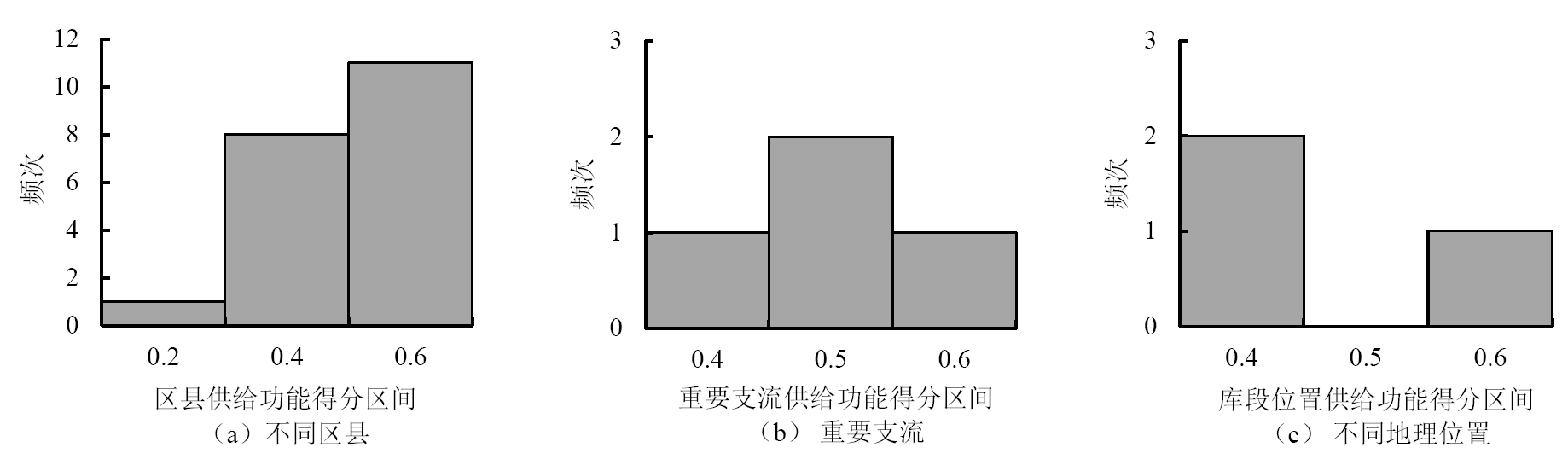
图3 三峡水库消落区生态系统供给功能得分频率分布
Figure 3 Frequency distribution of provisioning function scores in the ecosystem of Three Gorges Reservoir water-level-fluctuation zone
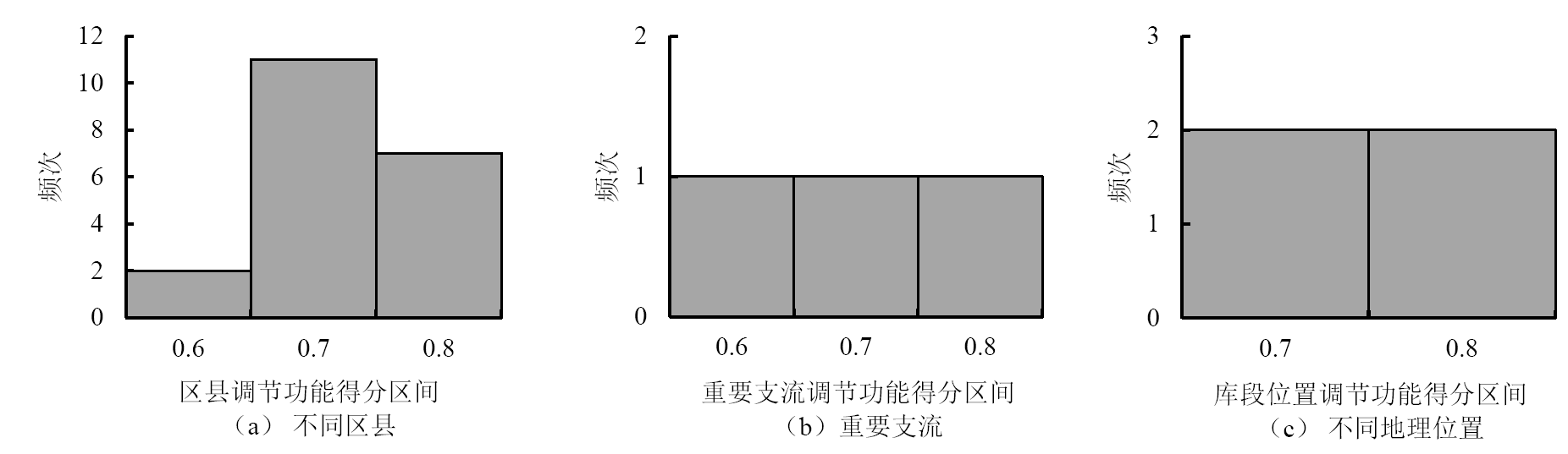
图4 三峡水库消落区生态系统调节功能得分频率分布
Figure 4 Frequency distribution of regulation function scores in the ecosystem of Three Gorges Reservoir water-level-fluctuation zone
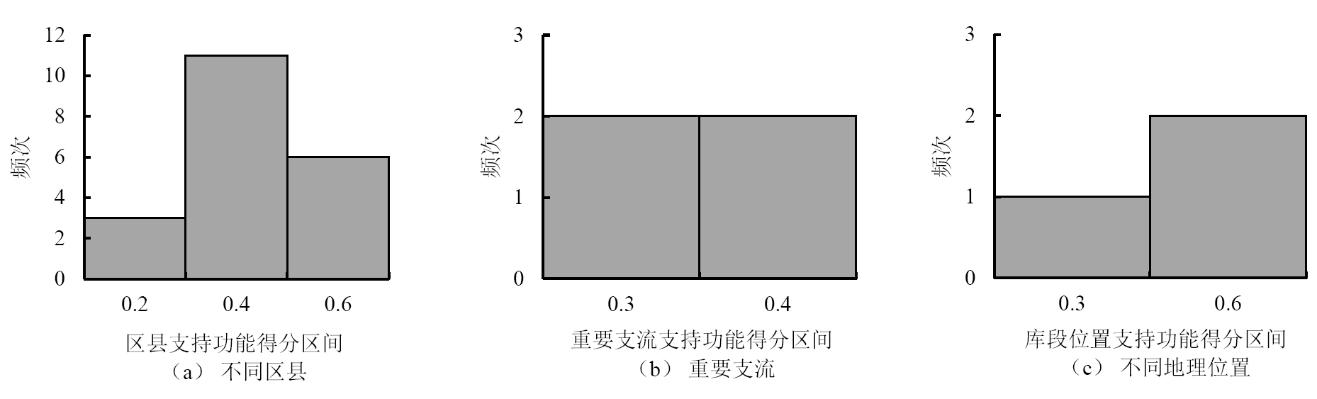
图5 三峡水库消落区生态系统支持功能得分频率分布
Figure 5 Frequency distribution of support function scores in the ecosystem of Three Gorges Reservoir water-level-fluctuation zone
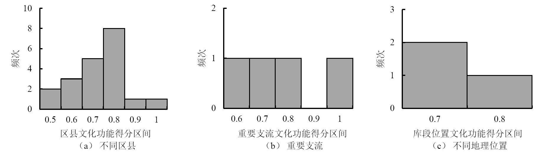
图6 三峡水库消落区生态系统文化功能得分频率分布
Figure 6 Frequency distribution of cultural function scores in the ecosystem of Three Gorges Reservoir water-level-fluctuation zone
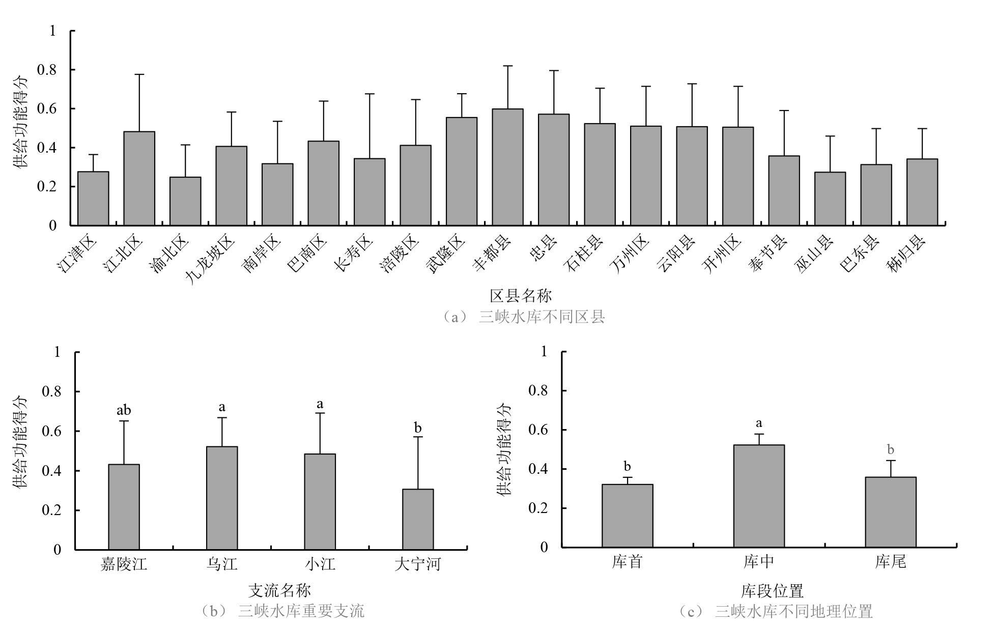
图7 三峡水库消落区生态系统供给功能空间分布
Figure 7 Spatial distribution of ecosystem provisioning function in the water-level-fluctuation zone of the Three Gorges Reservoir

图8 三峡水库消落区生态系统调节功能空间分布
Figure 8 Spatial distribution of ecosystem regulation function in the water-level-fluctuation zone of the Three Gorges Reservoir
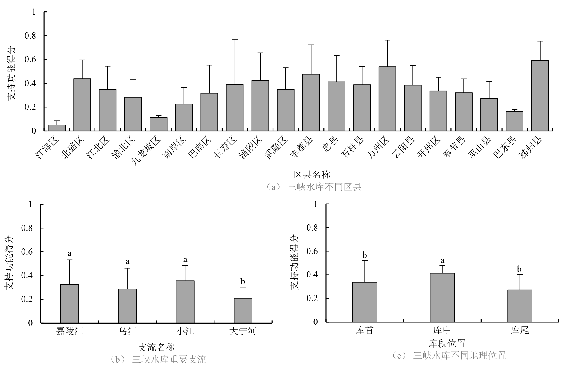
图9 三峡水库消落区生态系统支持功能空间分布
Figure 9 Spatial distribution of ecosystem support function in the water-level-fluctuation zone of the Three Gorges Reservoir
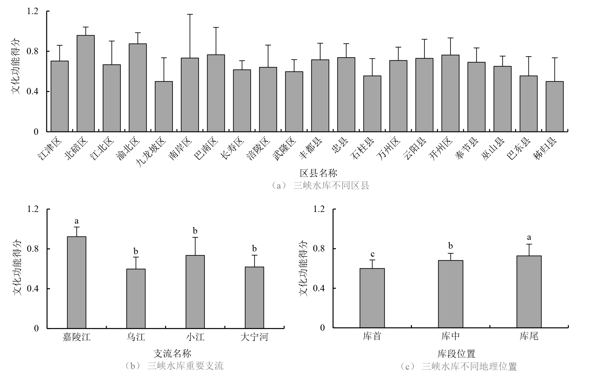
图10 三峡水库消落区生态系统文化功能空间分布
Figure 10 Spatial distribution of ecosystem cultural function in the water-level-fluctuation zone of the Three Gorges Reservoir
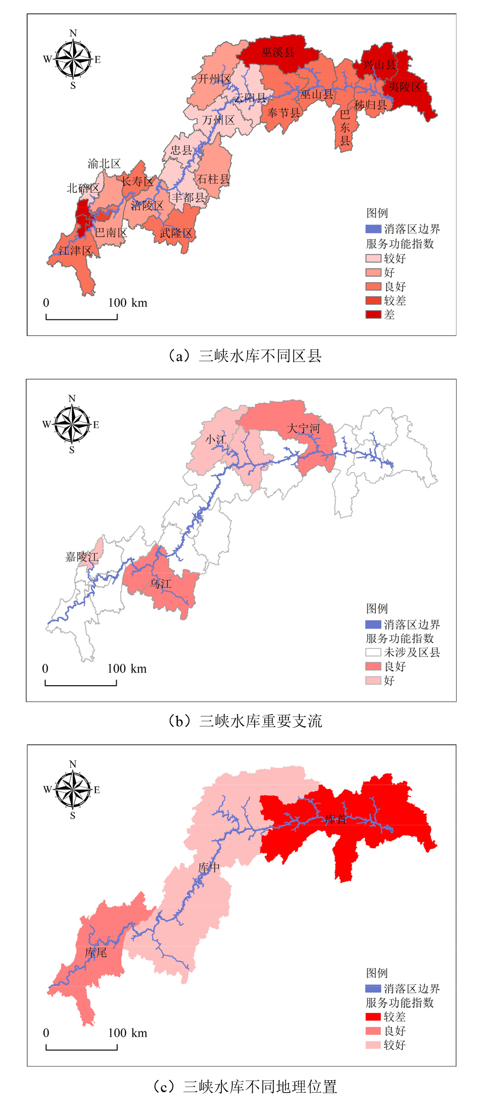
图11 三峡水库消落区生态系统服务功能指数空间分布
Figure 11 Spatial distribution of ecosystem Service Function Index in the water-level-fluctuation zone of the Three Gorges Reservoir
| [1] | COSTANZA R, ARGE, GROOT R D, et al., 1997. The value of the world’s ecosystem services and natural capital[J]. Nature, 387(15):253-260. |
| [2] |
LIN J J, ZHANG S, LIU D, et al., 2018. Mobility and potential risk of sediment-associated heavy metal fractions under continuous drought-rewetting cycles[J]. The Science of the Total Environment, 625:79-86.
DOI PMID |
| [3] | RIIS T, KELLY-QUINN M, AGUIAR F C, et al., 2020. Global overview of ecosystem services provided by riparian vegetation[J]. BioScience, 70(6):501-514. |
| [4] | JIANG Y C, OUYANG B, YAN Z G, 2024. Multiscale analysis for identifying the impact of human and natural factors on water-related ecosystem services[J]. Sustainability, 16(5):1738. |
| [5] | REID W V, MOONEY H A, CROPPER A, et al., 2005. Ecosystems and human well-being-synthesis: A report of the Millennium Ecosystem Assessment[M]. Washington: Island Press. |
| [6] | TEMPESTA T T M, 2022. The willingness to pay for the conservation of mountain landscape in Cortina D'Ampezzo (Italy)[J]. Environmental Economics and Policy Studies, 24(2):145-162. |
| [7] | 程曦, 刘肖凡, 陈林, 等, 2023. 喷射型多孔混凝土在水库消落区护坡中的喷射性能及施工工艺研究[J]. 水利水电快报, 44(12):54-58. |
| CHENG X, LIU X F, CHEN L, et al., 2023. Study on spraying performance and construction technology of sprayed porous concrete for slope protection in reservoir drawdown area[J]. Express Water Resources & Hydropower Information, 44(12):54-58. | |
| [8] | 杜立刚, 2013. 三峡库区消落带植被淹水碳氮磷释放及消落带氮磷交换通量研究[D]. 重庆: 重庆大学. |
| DU L G, 2013. Carbon, Nitrogen and phosphorus release from the vegetation and flux of nitrogen, phosphorus of WLFZ in the Three Gorges Reservoir[D]. Chongqing: Chongqing University. | |
| [9] | 冯晶红, 刘瑛, 肖衡林, 等, 2020. 三峡库区消落带典型植物光合固碳能力及影响因素[J]. 水土保持研究, 27(1):305-311. |
| FENG J H, LIU Y, XIAO H L, et al., 2020. Photosynthesis and carbon sequestration characteristics of typical plants and their influencing factors in reservoir riparian region of Three Gorges Reservoir[J]. Research of Soil and Water Conservation, 27(1):305-311. | |
| [10] |
高俊, 汪慧泉, 顾东祥, 等, 2023. 秸秆还田对土壤生态及农作物生长发育影响的研究进展[J]. 中国农学通报, 39(30):87-93.
DOI |
|
GAO J, WANG H Q, GU D X, et al., 2023. Effects of straw returning on soil ecology and crop growth and development[J]. Chinese Agricultural Science Bulletin, 39(30):87-93.
DOI |
|
| [11] | 高婷, 董蓉, 黄慧敏, 等, 2017. 三峡水库消落带出露期植物群落动态特征[J]. 重庆师范大学学报: 自然科学版, 34(5):38-43. |
| GAO T, DONG R, HUANG H M, et al., 2017. Plant community and ecology in Three Gorges Area[J]. Journal of Chongqing Normal University (Natural Science), 34(5):38-43. | |
| [12] | 郭崇炎, 张业刚, 2022. 三峡水库综合管理研究[J]. 水利水电技术(中英文), 53(S1):90-94. |
| GUO C Y, ZHANG Y G, 2022. Research on integrated management of Three Gorges Reservoir[J]. Water Resources and Hydropower Engineering, 53(S1):90-94. | |
| [13] |
何思源, 闵庆文, 2023. 自然保护地社区的保护兼容性生计: 概念与实施路径[J]. 自然资源学报, 38(4):862-873.
DOI |
| HE S Y, MIN Q W, 2023. Conservation-compatible livelihoods in protected areas: Concept and the implementation approach[J]. Journal of Natural Resources, 38(4):862-873. | |
| [14] | 贾岚, 刘立泳, 兰紫橙, 等, 2021. 武夷山国家公园生态环境变化及其驱动力分析[J]. 亚热带资源与环境学报, 16(4):15-25. |
| JIA L, LIU L Y, LAN Z C, et al., 2021. Analysis of ecological environment changes and driving forces in Wuyishan National Park[J]. Journal of Subtropical Resources and Environment, 16(4):15-25. | |
| [15] | 江建平, 蔡波, 王斌, 等, 2023. 中国脊椎动物2022年度新增物种报告[J]. 生物多样性, 31(10):17-22. |
| JIANG J P, CAI B, WANG B, et al., 2023. New vertebrate species discovered in China in 2022[J]. Biodiversity Science, 31(10):17-22. | |
| [16] | 江小青, 孔繁忠, 2020. 三峡库区库岸稳定与岸线变化趋势分析[J]. 长江技术经济, 4(2):5-11. |
| JIANG X Q, KONG F Z, 2020. Analysis on the trend of reservoir bank stability and shoreline change in the Three Gorges Reservoir Area[J]. Technology and Economy of Changjiang, 4(2):5-11. | |
| [17] | 井晶, 2015. 基于CVM的崂山水库生态系统服务价值评估研究[D]. 青岛: 青岛大学. |
| JING J, 2015. Study on the ecosystem service value assessment of Laoshan Reservoir based on CVM[D]. Qingdao: Qingdao University. | |
| [18] | 李奇, 朱建华, 肖文发, 2019. 生物多样性与生态系统服务——关系、权衡与管理[J]. 生态学报, 39(8):2655-2666. |
| LI Q, ZHU J H, XIAO W F, 2019. Relationships and trade-offs between, and management of biodiversity and ecosystem services[J]. Acta Ecological Sinica, 39(8):2655-2666. | |
| [19] | 卢德彬, 2012. 三峡库区消落带生态系统服务功能价值研究——以重庆开县消落带为例[D]. 重庆: 西南大学. |
| LU D B, 2012. Research on value of ecosystem services of water-level-fluctuating zone in Three Gorges Reservoir[D]. Chongqing: Southwest University. | |
| [20] | 罗美凤, 黄平, 王小晓, 等, 2023. 消落区植物群落对土壤团聚体稳定性的影响研究进展[J]. 生态学杂志, 42(10):2314-2326. |
| LUO M F, HUANG P, WANG X X, et al., 2023. Effects of plant communities on the stability of soil aggregates in the water-level-fluctuating area: A review[J]. Chinese Journal of Ecology, 42(10):2314-2326. | |
| [21] | 倪茂飞, 2019. 长江上游典型河流溶解性碳输运及水-气界面二氧化碳交换研究[D]. 重庆: 中国科学院大学(中国科学院重庆绿色智能技术研究院). |
| NI M F, 2019. Dissolved carbon transport and water-air carbon dioxide exchange in the representative rivers of the upper Yangtze River[D]. Chongqing: University of Chinese Academy of Sciences (Chongqing institute of Green and Intelligent Technology, Chinese Academy of Sciences). | |
| [22] | 潘金辉, 朱尧锋, 赖达健, 等, 2019. 消落带植物群落水深梯度配置技术[J]. 中国水土保持 (3):23-24, 65,69. |
| PAN J H, ZHU Y F, LAI D J, et al., 2019. Technique on water depth gradient allocation of plant community in water-level-fluctuating-zone[J]. Soil and Water Conservation in China (3):23-24, 65,69. | |
| [23] | 秦东旭, 2018. 三峡库区消落带生态恢复模式及其生态效应对比分析[D]. 武汉: 湖北工业大学. |
| QIN D X, 2018. Ecological restoration model and its ecological effects analysis for the water level fluctuating zone in Three Gorges Reservoir Area[D]. Wuhan: Hubei University of Technology. | |
| [24] | 群培, 格桑达瓦, 白玛格桑, 2023. 西藏阿里地区耕地质量监测数据分析及对策措施[J]. 西藏农业科技, 45(4):105-108. |
| QUN P, GESANG D W, BAIMA G S, 2023. Data analysis and countermeasures of cultivated land quality monitoring in Ali Prefecture, Tibet[J]. Tibet Journal of Agricultural Sciences, 45(4):105-108. | |
| [25] | 商思争, 张得银, 朱怡锦, 等, 2021. 连云港海洋生态系统服务价值评估[J]. 海洋经济, 11(6):50-61. |
| SHANG S Z, ZHANG D Y, ZHU Y J, et al., 2021. Evaluation of marine ecosystem service values in Lianyungang[J]. Marine Economy, 11(6):50-61. | |
| [26] | 王琳, 丁放, 曹坤, 等, 2023. 长江流域水域及消落区现状、变迁与渔业资源变动[J]. 水产学报, 47(2):31-49. |
| WANG L, DING F, CAO K, et al., 2023. Status and Transition of Surface water fluctuation zones in the Yangtze River Basin and Fishery Resource Change[J]. Journal of Fisheries of China, 47(2):31-49. | |
| [27] |
王富喜, 毛爱华, 李赫龙, 等, 2013. 基于熵值法的山东省城镇化质量测度及空间差异分析[J]. 地理科学, 33(11):1323-1329.
DOI |
| WANG F X, MAO A H, LI H L, et al., 2013. Quality measurement and regional difference of urbanization in Shandong province based on the entropy method[J]. Scientia Geographica Sinica, 33(11):1323-1329. | |
| [28] | 王文统, 赵进勇, 张晶, 等, 2023. 莱茵河两百年治理历程对我国河流生态修复相关工作的启示[J]. 环境生态学, 5(12):73-39, 86. |
| WANG W T, ZHAO J Y, ZHANG J, 2023. Inspiration of the two- hundred-year management history of the Rhine River for the river restoration in China[J]. Environmental Ecology, 5(12):73-39, 86. | |
| [29] | 王轶浩, 耿养会, 李彬, 等, 2010. 三峡库区消落带香根草水土保持功能研究[J]. 四川林业科技, 31(2):68-71. |
| WANG Y H, GENG Y H, LI B, et al., 2010. Water-level-fluctuation zone of Three Gorges Reservoir Area: Study on the water-level-fluctuation zone soil and water conservation function of vetiver grass[J]. Journal of Sichuan Forestry Science and Technology, 31(2):68-71. | |
| [30] | 肖志豪, 张仲伟, 何云蛟, 等, 2022. 三峡水库消落区自然植被群落分布特征[J]. 黑龙江环境通报, 35(1):1-5, 11. |
| XIAO Z H, ZHANG Z W, HE Y J, et al., 2022. Distribution characteristics of natural vegetation communities in the drawdown zone of the Three Gorges Reservoir[J]. Heilongjiang Environmental Journal, 35(1):1-5, 11. | |
| [31] | 殷鹏远, 臧英平, 沃玉报, 等, 2020. 长江南京段岸线管理与保护的研究与思考[J]. 水利发展研究, 20(11):49-52. |
| YIN Y P, ZANG Y P, WO Y B, et al., 2020. Research and thoughts on shoreline management and protection of the Nanjing section of the Yangtze River[J]. Water Resources Development Research, 20(11):49-52. | |
| [32] | 袁兴中, 杜春兰, 袁嘉, 等, 2019. 自然与人的协同共生之舞——三峡库区汉丰湖消落带生态系统设计与生态实践[J]. 国际城市规划, 34(3):37-44. |
| YUAN Z X, DU C L, YUAN J, et al., 2019. Dance of nature and man’s synergistic symbiosis: Ecosystem design and ecological practice of littoral zone of Hanfeng Lake in Three Gorges Reservoir Area[J]. Urban Planning International, 34(3):37-44. | |
| [33] | 袁兴中, 杜春兰, 袁嘉, 2017. 适应水位变化的多功能基塘系统: 塘生态智慧在三峡水库消落带生态恢复中的运用[J]. 景观设计学, 5(1):8-21. |
| YUAN Z X, DU C L, YUAN J, 2017. Multi-functional dike-pond system adaptive to water level change: Application of pond-based ecological wisdom in ecological restoration of the hydro-fluctuation belt of the Three Gorges Reservoir[J]. Landscape Design Magazine, 5(1):8-21. | |
| [34] | 张建亚, 2015. 消落带生态补偿标准研究探讨[J]. 绿色科技 (5):12-15. |
| ZHANG J Y, 2015. Research and discussion on the standard of ecological compensation in hydro-fluctuation belt[J]. Journal of Green Science and Technology (5):12-15. | |
| [35] | 张业刚, 赖红兵, 2023. 三峡水库消落区利用和保护管理现状与建议[J]. 中国水利 (17):24-28. |
| ZHANG Y G, LAI H B, 2023. Current status and recommendations for the utilization and conservation management of riparian zones in the Three Gorges Reservoir[J]. China Water Resources (17):24-28. | |
| [36] | 赵婧滢, 林来昌, 真翎, 等, 2022. 基于生态环境损害赔偿背景下湿地生态系统服务功能体系构建[J]. 四川环境, 41(3):234-242. |
| ZHAO J Y, LIN L C, ZHEN L, et al., 2022. Construction of wetland ecosystem service function system under the background of eco-environmental damage compensation[J]. Sichuan Environment, 41(3):234-242. | |
| [37] | 赵同谦, 欧阳志云, 郑华, 等, 2006. 水电开发的生态环境影响经济损益分析——以怒江中下游为例[J]. 生态学报, 26(9):2979-2988. |
| ZHAO T Q, OUYANG Z Y, ZHENG H, et al., 2006. Economic cost-benefit analysis of environmental impact of hydropower development projects: A case study in the middle and lower reaches of the Nu River, China[J]. Acta Ecological Sinica, 26(9):2979-2988. | |
| [38] | 邹天娥, 丁明军, 张华, 等, 2024. 环鄱阳湖消落区湿地土壤重金属的赋存形态及影响因素分析[J]. 环境科学学报, 44(3):354-364. |
| ZHOU T E, DING M J, ZHANG H, et al., 2024. Analysis of chemical fraction of soil heavy metals and their influence factors in the water-level-fluctuating wetland around the Poyang Lake[J]. Acta Scientiae Circumstantiae, 44(3):354-364. | |
| [39] | 朱昊彧, 2021. 反季节调节水库消落带氮循环特征及其机制[D]. 重庆: 重庆交通大学. |
| ZHU H Y, 2021. Characteristics and mechanism of nitrogen cycle in the water level fluctuation zone of the reservoir under anti-season regulation[D]. Chongqing: Chongqing Jiaotong University. |
| [1] | 王薇, 夏宇轩. 基于遥感技术和机器学习的城市街区PM2.5空间分布特征研究——以合肥市滨湖新区为例[J]. 生态环境学报, 2024, 33(9): 1426-1437. |
| [2] | 欧阳美凤, 尹宇莹, 张金谌, 刘清霖, 谢意南, 方平. 洞庭湖典型水域重金属含量的空间分布与来源解析[J]. 生态环境学报, 2024, 33(8): 1269-1278. |
| [3] | 高文明, 宋芊, 张皓翔, 王士如. 基于生态系统服务功能和保护动物栖息地适宜性评价的优先保护区选取——以三江源地区为例[J]. 生态环境学报, 2024, 33(8): 1318-1328. |
| [4] | 向男, 王明旭, 张宏锋, 廖宝淦. 生态保护重要性分区及其长时间序列生境状况时空分异研究——以广东省为例[J]. 生态环境学报, 2024, 33(6): 958-968. |
| [5] | 梁贝竹, 陈建耀, 杨再智, 张鹏程, 任坤, 梁作兵, 杨晨晨, 吴洁珊. 华南滨海小流域地下水中PPCPs的分布、来源及影响因素——以珠海市唐家湾镇为例[J]. 生态环境学报, 2024, 33(2): 249-260. |
| [6] | 韦钰, 胡颖, 李小珍, 廖家培, 付瑞玉, 胡中民, 杨岳. 全球草地生态系统净初级生产力的空间格局及降水非对称响应[J]. 生态环境学报, 2024, 33(12): 1827-1836. |
| [7] | 高星星, 包海, 丁艳旭. 夏季呼和浩特市生物源挥发性有机物排放速率空间分布[J]. 生态环境学报, 2024, 33(12): 1902-1913. |
| [8] | 董智今, 张呈春, 展秀丽, 张维福. 宁夏河东沙地生物土壤结皮及其下伏土壤养分的空间分布特征[J]. 生态环境学报, 2023, 32(5): 910-919. |
| [9] | 杨春亮, 刘旻霞, 王千月, 苗乐乐, 肖音迪, 王敏. 单户与联户放牧经营下草玉梅与嵩草种群空间格局及其关联性[J]. 生态环境学报, 2023, 32(4): 651-659. |
| [10] | 陈敏毅, 宋清梅, 叶权运, 游学睿, 吴颖欣. 华南典型金属制品遗留生产场地重金属空间分布特征[J]. 生态环境学报, 2023, 32(12): 2228-2235. |
| [11] | 吴胜义, 王飞, 徐干君, 马浩, 党禹杰, 吴菲. 川西北高山峡谷区森林碳储量及空间分布研究--以四川洛须自然保护区为例[J]. 生态环境学报, 2022, 31(9): 1735-1744. |
| [12] | 李秀华, 赵玲, 滕应, 骆永明, 黄标, 刘冲, 刘本乐, 赵其国. 贵州汞矿区周边农田土壤汞镉复合污染特征空间分布及风险评估[J]. 生态环境学报, 2022, 31(8): 1629-1636. |
| [13] | 温智峰, 魏识广, 李林, 叶万辉, 练琚愉. 南亚热带常绿阔叶林植物不同分类水平上的空间分布格局及空间关联[J]. 生态环境学报, 2022, 31(3): 440-450. |
| [14] | 刘娣, 苏超, 张红, 秦冠宇. 典型煤炭产业聚集区土壤重金属污染特征与风险评价[J]. 生态环境学报, 2022, 31(2): 391-399. |
| [15] | 张楷悦, 刘增辉, 王颜昊, 王敬宽, 崔德杰, 柳新伟. 黄河三角洲自然保护区土壤PAHs的风险评估和空间特征[J]. 生态环境学报, 2022, 31(11): 2198-2205. |
| 阅读次数 | ||||||
|
全文 |
|
|||||
|
摘要 |
|
|||||