Ecology and Environmental Sciences ›› 2026, Vol. 35 ›› Issue (4): 540-550.DOI: 10.16258/j.cnki.1674-5906.2026.04.005
• Research Article [Ecology] • Previous Articles Next Articles
QIN Qunce1( ), LI Lianwei1,*(), ZHENG Zhi2
Received:2025-09-16
Revised:2026-02-03
Accepted:2026-03-07
Online:2026-04-18
Published:2026-04-14
秦群策1(), 李连伟1,*(), 郑直2
通讯作者:
*E-mail: 作者简介:秦群策(2002年生),男,硕士研究生,主要从事生态脆弱性情景模拟研究。E-mail: 1924863414@qq.com
基金资助:CLC Number:
QIN Qunce, LI Lianwei, ZHENG Zhi. Spatio-temporal Evolution Analysis of Ecological Vulnerability in Qingdao City Based on the SRP Model[J]. Ecology and Environmental Sciences, 2026, 35(4): 540-550.
秦群策, 李连伟, 郑直. 基于SRP模型的青岛市生态脆弱性时空演变分析[J]. 生态环境学报, 2026, 35(4): 540-550.
Add to citation manager EndNote|Ris|BibTeX
URL: https://www.jeesci.com/EN/10.16258/j.cnki.1674-5906.2026.04.005

Figure 1 Elevation and location of counties in the Qingdao Region
| 数据 | 数据源 | 时间范围 | 分辨率 | 数据格式 |
|---|---|---|---|---|
| DEM数据 | 地理空间数据云平台( | GDEMV2(2015年);GDEMV3(2019年) | 30 m | GEOTIFF |
| 气象数据 | WorldClim全球气候数据库(Fick and Hijmans, | 2011-2021年月尺度 | 2.5' | GEOTIFF |
| 土地利用类型数据 | The 30m annual land cover datasets and its dynamics in China from 1990 to 2021( | 2011-2021年 | 30 m | GEOTIFF |
| 植被净初级生产力 | NASA地球科学网站( | 2011-2021年 | 500 m | GEOTIFF |
| NDVI | Landsat系列卫星影像 | 2011-2021年 | 30 m | GEOTIFF |
| 人口分布数据 | LandScan Datasets( | 2011-2021年 | 1 km | GEOTIFF |
| GDP | 青岛市统计年鉴 | 2011-2021年 | 统计数据 | 表格数据 |
| 夜间灯光 | 类NPP-VIIRS夜间灯光数据集(Chen et al., | 2011-2021年 | 500 m | GEOTIFF |
Table 1 Data sources
| 数据 | 数据源 | 时间范围 | 分辨率 | 数据格式 |
|---|---|---|---|---|
| DEM数据 | 地理空间数据云平台( | GDEMV2(2015年);GDEMV3(2019年) | 30 m | GEOTIFF |
| 气象数据 | WorldClim全球气候数据库(Fick and Hijmans, | 2011-2021年月尺度 | 2.5' | GEOTIFF |
| 土地利用类型数据 | The 30m annual land cover datasets and its dynamics in China from 1990 to 2021( | 2011-2021年 | 30 m | GEOTIFF |
| 植被净初级生产力 | NASA地球科学网站( | 2011-2021年 | 500 m | GEOTIFF |
| NDVI | Landsat系列卫星影像 | 2011-2021年 | 30 m | GEOTIFF |
| 人口分布数据 | LandScan Datasets( | 2011-2021年 | 1 km | GEOTIFF |
| GDP | 青岛市统计年鉴 | 2011-2021年 | 统计数据 | 表格数据 |
| 夜间灯光 | 类NPP-VIIRS夜间灯光数据集(Chen et al., | 2011-2021年 | 500 m | GEOTIFF |
| 目标层 | 要素层 | 指标层 | 指标名称 | 性质 | 指标权重 |
|---|---|---|---|---|---|
| 生态脆弱性 | 生态敏感性 | 地形因子 | 高程X1 | 正向 | 0.0017 |
| 坡度X2 | 正向 | 0.0366 | |||
| 坡向X3 | 负向 | 0.0382 | |||
| 地表起伏度X4 | 正向 | 0.0224 | |||
| 气象因子 | 年平均降水量X5 | 负向 | 0.0133 | ||
| 年极端最高温度X6 | 负向 | 0.0267 | |||
| 年极端最低温度X7 | 正向 | 0.0396 | |||
| 地表因子 | 土地利用类型X8 | 定性 | 0.0788 | ||
| 斑块聚集度X9 | 正向 | 0.0140 | |||
| 生态恢复力 | 植被因子 | 植被净初级生产力X10 | 负向 | 0.0254 | |
| 生物丰富度X11 | 负向 | 0.0203 | |||
| 植被覆盖度X12 | 负向 | 0.0457 | |||
| NDVI X13 | 负向 | 0.0314 | |||
| 生态压力度 | 社会经济因子 | 人口密度X14 | 正向 | 0.3182 | |
| GDP X15 | 正向 | 0.1991 | |||
| 夜间灯光X16 | 正向 | 0.0886 |
Table 2 Indicator system for ecological vulnerability assessment in qingdao based on the SRP model
| 目标层 | 要素层 | 指标层 | 指标名称 | 性质 | 指标权重 |
|---|---|---|---|---|---|
| 生态脆弱性 | 生态敏感性 | 地形因子 | 高程X1 | 正向 | 0.0017 |
| 坡度X2 | 正向 | 0.0366 | |||
| 坡向X3 | 负向 | 0.0382 | |||
| 地表起伏度X4 | 正向 | 0.0224 | |||
| 气象因子 | 年平均降水量X5 | 负向 | 0.0133 | ||
| 年极端最高温度X6 | 负向 | 0.0267 | |||
| 年极端最低温度X7 | 正向 | 0.0396 | |||
| 地表因子 | 土地利用类型X8 | 定性 | 0.0788 | ||
| 斑块聚集度X9 | 正向 | 0.0140 | |||
| 生态恢复力 | 植被因子 | 植被净初级生产力X10 | 负向 | 0.0254 | |
| 生物丰富度X11 | 负向 | 0.0203 | |||
| 植被覆盖度X12 | 负向 | 0.0457 | |||
| NDVI X13 | 负向 | 0.0314 | |||
| 生态压力度 | 社会经济因子 | 人口密度X14 | 正向 | 0.3182 | |
| GDP X15 | 正向 | 0.1991 | |||
| 夜间灯光X16 | 正向 | 0.0886 |
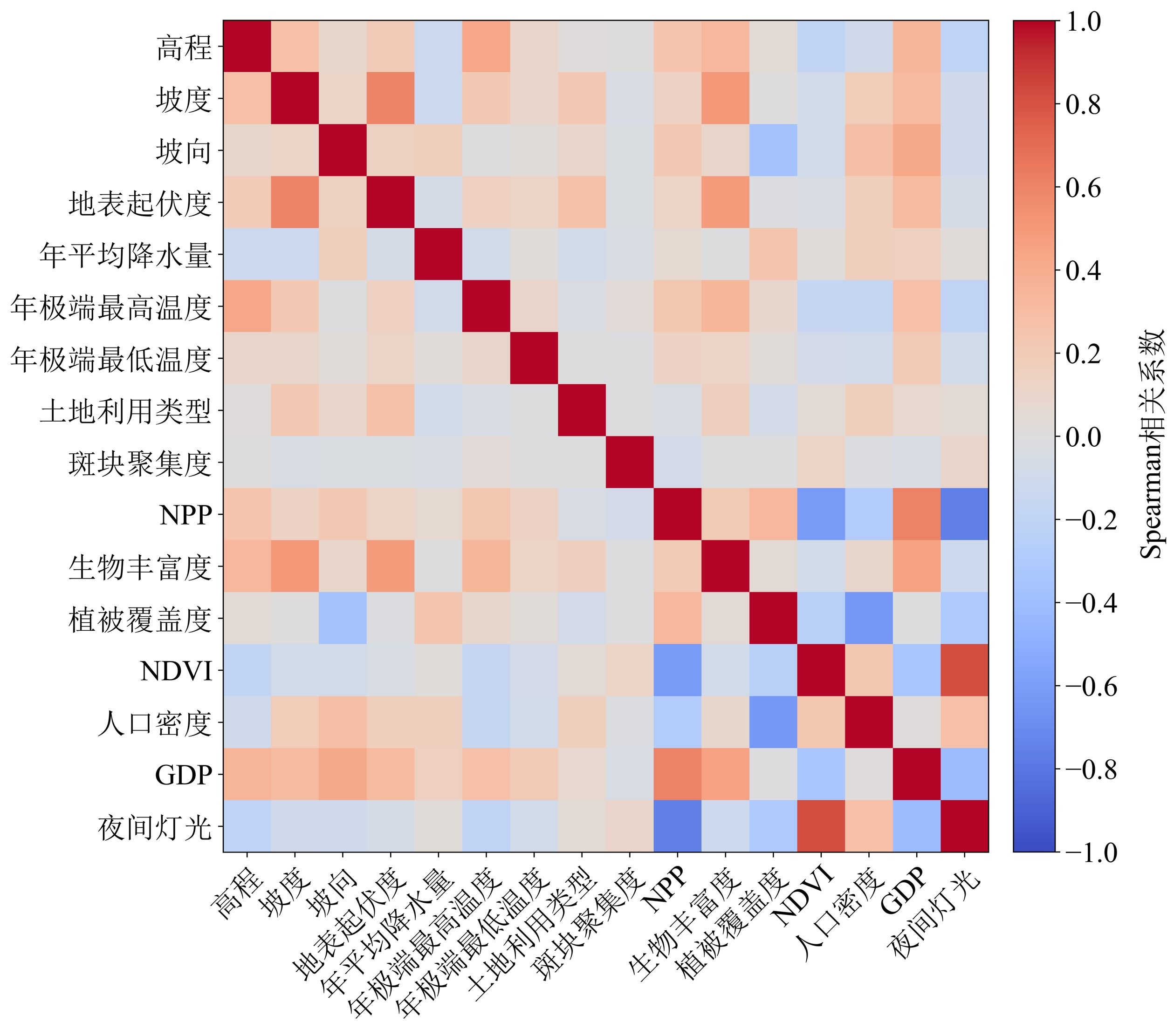
Figure 2 Spearman correlation coefficient matrix
| 脆弱等级 | 脆弱度范围 |
|---|---|
| 微度脆弱 | 0-0.318 |
| 轻度脆弱 | 0.318-0.392 |
| 中度脆弱 | 0.392-0.454 |
| 重度脆弱 | 0.454-0.555 |
| 极度脆弱 | 0.555-0.761 |
Table 3 Value ranges of vulnerability grades
| 脆弱等级 | 脆弱度范围 |
|---|---|
| 微度脆弱 | 0-0.318 |
| 轻度脆弱 | 0.318-0.392 |
| 中度脆弱 | 0.392-0.454 |
| 重度脆弱 | 0.454-0.555 |
| 极度脆弱 | 0.555-0.761 |

3 Spatial distribution of ecological vulnerability from 2011 to 2021
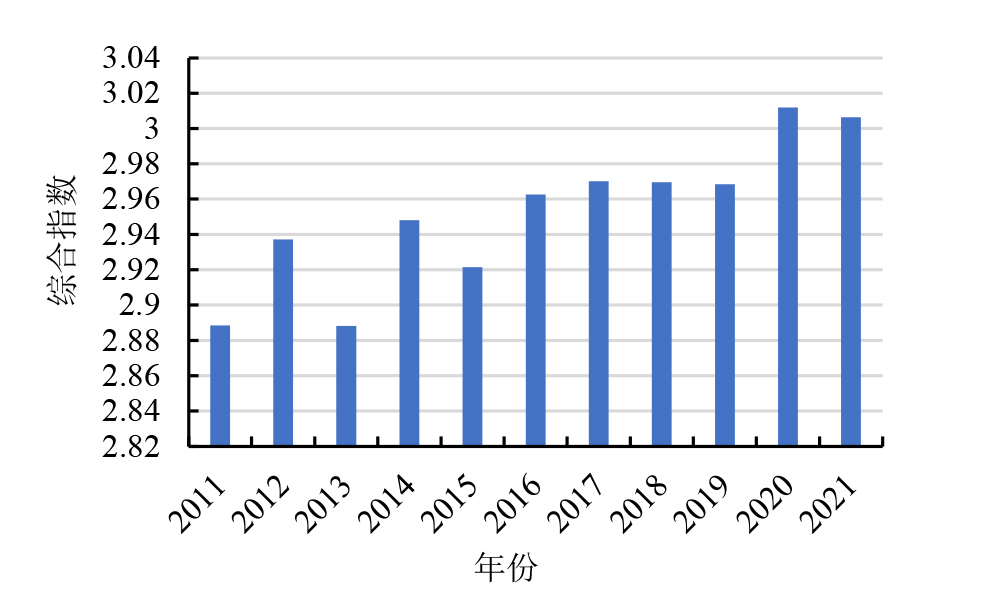
图4 Change in the composite index of ecological vulnerability
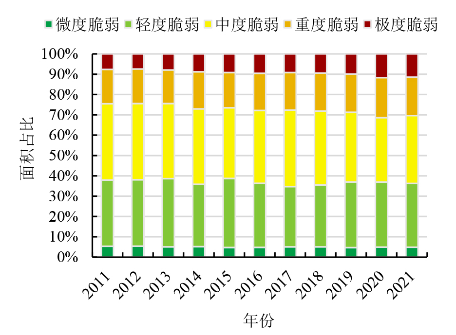
Figure 5 Statistics of changes in the area percentage of different ecological vulnerability grades in Qingdao from 2011 to 2021
| 年份 | Moran’s I指数 | Z值 |
|---|---|---|
| 2011 | 0.704 | 104.369 |
| 2012 | 0.710 | 105.310 |
| 2013 | 0.734 | 108.848 |
| 2014 | 0.715 | 106.081 |
| 2015 | 0.737 | 109.324 |
| 2016 | 0.730 | 108.257 |
| 2017 | 0.722 | 107.096 |
| 2018 | 0.725 | 107.557 |
| 2019 | 0.763 | 113.212 |
| 2020 | 0.770 | 114.180 |
| 2021 | 0.761 | 112.907 |
Table 4 Global spatial autocorrelation of ecological vulnerability in Qingdao
| 年份 | Moran’s I指数 | Z值 |
|---|---|---|
| 2011 | 0.704 | 104.369 |
| 2012 | 0.710 | 105.310 |
| 2013 | 0.734 | 108.848 |
| 2014 | 0.715 | 106.081 |
| 2015 | 0.737 | 109.324 |
| 2016 | 0.730 | 108.257 |
| 2017 | 0.722 | 107.096 |
| 2018 | 0.725 | 107.557 |
| 2019 | 0.763 | 113.212 |
| 2020 | 0.770 | 114.180 |
| 2021 | 0.761 | 112.907 |

Figure 6 Results of global spatial autocorrelation analysis for ecological vulnerability in Qingdao
| [1] |
ANSELIN L, 1995. Local indicators of spatial association-LISA[J]. Geographical Analysis, 27(2): 93-115.
DOI URL |
| [2] |
CARLSON T N, RIPLEY D A, 1997. On the relation between NDVI, fractional vegetation cover, and leaf area index[J]. Remote Sensing of Environment, 62(3): 241-252.
DOI URL |
| [3] |
CHEN Y Y, DUO L H, ZHAO D X, et al., 2023. The response of ecosystem vulnerability to climate change and human activities in the Poyang lake city group, China[J]. Environmental Research, 233: 116473.
DOI URL |
| [4] |
CHEN Z Q, YU B L, YANG C S, et al., 2021. An extended time series (2000-2018) of global NPP-VIIRS-Like nighttime light data from a cross-sensor calibration[J]. Earth System Science Data, 13(3): 889-906.
DOI URL |
| [5] |
DE LANGE H J, SALA S, VIGHI M, et al., 2010. Ecological vulnerability in risk assessment: A review and perspectives[J]. Science of The Total Environment, 408(18): 3871-3879.
DOI URL |
| [6] |
FICK S E, HIJMANS R J, 2017. WorldClim 2: new 1 km spatial resolution climate surfaces for global land areas[J]. International Journal of Climatology, 37: (12): 4302-4315.
DOI URL |
| [7] |
LUO M Y, JIA X, ZHAO Y H, et al., 2024. Ecological vulnerability assessment and its driving force based on ecological zoning in the loess plateau, China[J]. Ecological Indicators, 159: 111658.
DOI URL |
| [8] |
YANG J, HUANG X, 2021. The 30 m annual land cover dataset and its dynamics in China from 1990 to 2019[J]. Earth System Science Data, 13(8): 3907-3925.
DOI URL |
| [9] |
ZHANG X, ZHENG Y, YANG Y, et al., 2025. Spatiotemporal evolution of ecological vulnerability on the loess plateau[J]. Ecological Indicators, 170: 113060.
DOI URL |
| [10] | 奥勇, 丁志豪, 赵永华, 等, 2025. 汉江流域生态脆弱性与生态韧性的时空演变及生态分区构建[J/OL]. 环境科学, 1-20 [2025-12-30]. https://doi.org/10.13227/j.hjkx.202504102. |
| AO Y, DING Z H, ZHAO Y H, et al., 2025. Spatial and temporal evolution of ecological vulnerability and ecological resilience and construction of ecological zones in Hanjiang River Basin[J/OL]. Environmental Science, 1-20 [2025-12-30]. https://doi.org/10.13227/j.hjkx.202504102. | |
| [11] |
包微, 黄晓军, 纪王迪, 2024. 关中地区高温脆弱性评估及其时空变化研究[J]. 干旱区地理, 47(11): 1863-1875.
DOI |
|
BAO W, HUANG X J, JI W D, 2024. Evaluation of heat vulnerability and its spatial-temporal variation in the Guanzhong area[J]. Arid Land Geography, 47(11): 1863-1875.
DOI |
|
| [12] | 常溢华, 蔡海生, 2022. 基于SRP模型的多尺度生态脆弱性动态评价: 以江西省鄱阳县为例[J]. 江西农业大学学报, 44(1): 245-260. |
| CHANG Y H, CAI H S, 2022. Dynamic assessment of multi-scale eco-environmental vulnerability based on SRP model in Poyang County[J]. Acta Agriculturae Universitatis Jiangxiensis, 44(1): 245-260. | |
| [13] | 陈康富, 吴隽宇, 2023. 粤港澳大湾区城市群生态保护优先区识别研究[J]. 生态学报, 43(10): 3855-3868. |
| CHEN K F, WU J Y, 2023. Identification of ecological conservation priority areas in urban agglomeration of Guangdong-Hong Kong-Macao Greater Bay Area[J]. Acta Ecologica Sinica, 43(10): 3855-3868. | |
| [14] | 成英文, 2019. 基于层次分析法的中国部分城市旅游化水平评价[J]. 科学技术与工程, 19(33): 336-341. |
| CHENG Y W, 2019. Evaluation of tourism function of China’s key cities based on analytic hierarchy process[J]. Science Technology and Engineering, 19(33): 336-341. | |
| [15] | 邓起泉, 2023. 基于熵值法—层次分析法的重庆市生态环境质量综合评价[D]. 重庆: 西南大学: 38-47. |
| DENG Q Q, 2023. Comprehensive evaluation of ecological environment quality in Chongqing based on entropy method and AHP[D]. Chongqing: Southwest University: 38-47. | |
| [16] |
高文明, 宋芊, 张皓翔, 等, 2024. 三江源区生态脆弱性时空演变及驱动因素分析[J]. 生态环境学报, 33(10): 1648-1660.
DOI |
| GAO W M, SONG Q, ZHANG H X, et al., 2024. Analysis of spatial and temporal changes and driving factors of ecological vulnerability in Sanjiangyuan Region[J]. Ecology and Environmental Sciences, 33(10): 1648-1660. | |
| [17] | 环境保护部, 2015. 生态环境状况评价技术规范:HJ192—2015[S]. 北京: 中国环境科学出版社: 3-4. |
| Ministry of Environmental Protection of the People’s Republic of China, 2015. Technicalcriterionforecosystemstatusevaluation:HJ192—2015[S]. Beijing: China Environmental Science Press: 3-4. | |
| [18] | 康鸿源, 付豪, 徐书名, 等, 2025. 济宁市湿地生态脆弱性评价研究[J]. 安全与环境工程, 32(4): 347-358. |
| KANG H Y, FU H, XU S M, et al., 2025. Assessment study on ecological vulnerability of Jining wetland[J]. Safety and Environ-mental Engineering, 32(4): 347-358. | |
| [19] |
林墨飞, 关雅文, 连艺霏, 2025. 基于SRP模型的塔里木胡杨林公园生态脆弱性研究[J]. 干旱区地理, 48(11): 2019-2030.
DOI |
| LIN M F, GUAN Y W, LIAN Y F, 2025. Ecological vulnerability assessment of Tarim Populus euphratica forest park based on SRP model[J]. Arid Land Geography, 48(11): 2019-2030. | |
| [20] | 刘佳茹, 赵军, 沈思民, 等, 2020. 基于SRP概念模型的祁连山地区生态脆弱性评价[J]. 干旱区地理, 43(6): 1573-1582. |
|
LIU J R, ZHAO J, SHEN S M, et al., 2020. Ecological vulnerability assessment of Qilian Mountains region based on SRP conceptual model[J]. Arid Land Geography, 43(6): 1573-1582.
DOI |
|
| [21] | 刘若琦, 黄志强, 2024. 基于AHP-GIS的宜春市生态敏感性评价[J]. 地理空间信息, 22(4): 54-59. |
| HUANG R Q, HUANG Z Q, 2024. Ecological sensitivity evaluation of Yichun city based on AHP-GIS[J]. Geospatial Information, 22(4): 54-59. | |
| [22] | 乔青, 高吉喜, 王维, 等, 2008. 生态脆弱性综合评价方法与应用[J]. 环境科学研究, 21(5): 117-123. |
| QIAO Q, GAO J X, WANG W, et al., 2008. Method and application of ecological frangibility assessment[J]. Research of Environmental Sciences, 21(5): 117-123. | |
| [23] | 秦金波, 齐述华, 胡梅, 等, 2025. 基于SRP模型的江西省生态脆弱性变化及驱动机制[J/OL]. 环境科学, 1-17 [2025-12-30]. https://doi.org/10.13227/j.hjkx.202412309. |
| QIN J B, QI S H, HU M, et al., 2025. Changes and driving mechanisms of ecological vulnerability in Jiangxi province based on SRP model[J/OL]. Environmental Science, 1-17 [2025-12-30]. https://doi.org/10.13227/j.hjkx.202412309. | |
| [24] | 全国国土资源标准化技术委员会 (SAC/TC 93), 2017. 土地利用现状分类:GB/T21010—2017[S]. 北京: 中国标准出版社: 1-10. |
| Natural Resources and Territory Spatial Planning, 2017. Currentlanduseclassification:GB/T21010—2017[S]. Beijing: Standards Press of China: 1-10. | |
| [25] |
孙桂丽, 陆海燕, 郑佳翔, 等, 2022. 新疆生态脆弱性时空演变及驱动力分析[J]. 干旱区研究, 39(1): 258-269.
DOI |
|
SUN G L, LU H Y, ZHENG J X, et al., 2022. Spatio-temporal variation of ecological vulnerability in Xinjiang and driving force analysis[J]. Arid Zone Research, 39(1): 258-269.
DOI |
|
| [26] |
孙智杰, 曾嘉, 王辛, 等, 2023. 基于GIS的通城县生态环境地质脆弱性评价[J]. 资源环境与工程, 37(5): 560-566.
DOI |
| SUN Z J, ZENG J, WANG X, 2023. Evaluation of eco-environmental geological vulnerability in Tongcheng county based on GIS[J]. Resources Environment & Engineering, 37(5): 560-566. | |
| [27] | 王莹莹, 王心悦, 曾建军, 2025. 基于VSD模型的疏勒河流域生态脆弱性评价及驱动力分析[J/OL]. 水生态学杂志, 1-12 [2025-12-30]. https://doi.org/10.15928/j.1674-3075.202411070002. |
| WANG Y Y, WANG X Y, ZENG J J, 2025. Ecological vulnerability assessment and driving force analysis of Shule River Basin based on VSD model[J/OL]. Journal of Hydroecology, 1-12 [2025-12-30]. https://doi.org/10.15928/j.1674-3075.202411070002. | |
| [28] |
肖成志, 计扬, 李建忠, 等, 2023. 岷江上游生态脆弱性时空分异及驱动因子交互效应分析——以杂谷脑河流域为例[J]. 生态环境学报, 32(10): 1760-1770.
DOI |
| XIAO C Z, JI Y, LI J Z, et al., 2023. Spatial and temporal differentiation of ecological vulnerability and interaction effects of driving factors in the upper reaches of the Minjiang River: A case study of the Zagunao River basin[J]. Ecology and Environmental Sciences, 32(10): 1760-1770. | |
| [29] | 徐广才, 康慕谊, METZGER M, 等, 2012. 锡林郭勒盟生态脆弱性[J]. 生态学报, 32(5): 1643-1653. |
|
XU G C, KANG M Y, MARC METZGER, et al., 2012. Ecological vulnerability research for Xilingol League, northern China[J]. Acta Ecologica Sinica, 32(5): 1643-1653.
DOI URL |
|
| [30] | 杨飞, 马超, 方华军, 2019. 脆弱性研究进展: 从理论研究到综合实践[J]. 生态学报, 39(2): 441-453. |
| YANG F, MA C, FANG H J, 2019. Research progress on vulnerability: From theoretical research to comprehensive practice[J]. Acta Ecologica Sinica, 39(2): 441-453. | |
| [31] | 喻春哲, 于欢, 项清, 等, 2024. 四川省生态脆弱性时空分异及其驱动机制[J]. 环境科学, 45(12): 6922-6934. |
| YU C Z, YU H, XIANG Q, et al., 2024. Spatio-temporal differentiation and its driving mechanism of ecological vulnerability in Sichuan province[J]. Environmental Science, 45(12): 6922-6934. | |
| [32] | 郑慧玲, 郑辉峰, 2025. 粤港澳大湾区生态脆弱性与城镇化水平时空耦合及其交互影响因素[J/OL]. 环境科学, 1-23 [2025-12-30]. https://doi.org/10.13227/j.hjkx.202410113. |
| ZHENG H H, ZHENG Y F, 2025. Spatiotemporal coupling of ecological vulnerability and urbanization level and their interactive influencing factors in the Guangdong-Hong Kong-Macao Greater Bay Area[J/OL]. Environmental Science, 1-23 [2025-12-30]. https://doi.org/10.13227/j.hjkx.202410113. | |
| [33] | 朱妍, 王蜜蕾, 薛碧颖, 等, 2023. 青岛市海岸带地质环境问题与空间规划对策建议[J]. 海洋地质前沿, 39(8): 1-7. |
| ZHU Y, WANG M L, XUE B Y, et al., 2023. Geological environment issues and spatial planning countermeasures in the coastal zone of Qingdao City[J]. Marine Geology Frontiers, 39(8): 1-7. | |
| [34] | 邹桃红, 常雅轩, 陈鹏, 等, 2023. 基于AHP-PCA熵权组合模型的吉林省生态环境脆弱性动态评价[J]. 中国生态农业学报(中英文), 31(9): 1511-1524. |
| ZOU T H, CHANG Y X, CHEN P, 2023. Evaluation of eco-environmental vulnerability in Jilin province based on an AHP-PCA entropy weight model[J]. Chinese Journal of Eco-Agriculture, 31(9): 1511-1524. |
| [1] | YU Qianru, PEI Sha, LIU Chunlan, QIAO Qing, ZHENG Fangyu, ZHU Linhong. Research on Assessing the Ecosystem Regulating Service Scarcity and Spatial Aggregation Characteristics in Beijing Based on a Multi-Dimensional Perspective [J]. Ecology and Environmental Sciences, 2025, 34(7): 1133-1146. |
| [2] | BU Lingxin, QIN Mengting, FENG Kepeng, LAI Quan. Evaluation of the Ecological Vulnerability of Grassland Ecosystems in Arid and Semi-arid Regions under the Background of Climate Change [J]. Ecology and Environmental Sciences, 2025, 34(12): 1827-1840. |
| [3] | YANG Feifan, HE Hao. Ecological Environment Assessment and Ecological Zoning Construction in the Ili River Valley Based on EVI-ESV [J]. Ecology and Environmental Sciences, 2024, 33(4): 655-664. |
| [4] | GAO Wenming, SONG Qian, ZHANG Haoxiang, WANG Shiru. Analysis of Spatial and Temporal Changes and Driving Factors of Ecological Vulnerability in Sanjiangyuan Region [J]. Ecology and Environmental Sciences, 2024, 33(10): 1648-1660. |
| [5] | XIAO Bo, WANG Shaojun, XIE Lingling, WANG Zhengjun, GUO Zhipeng, ZHANG Kunfeng, ZHANG Lulu, FAN Yuxiang, GUO Xiaofei, LUO Shuang, XIA Jiahui, LI Rui, LAN Mengjie, YANG Shengqiu. Effect of Ant Nesting Activity on Soil Nitrogen Component Allocation in the Xishuangbanna Tropical Forests [J]. Ecology and Environmental Sciences, 2023, 32(6): 1026-1036. |
| [6] | WANG Jiali, FENG Jingke, YANG Yuanzheng, ZU Jiaxing, CAI Wenhua, YANG Jian. Research on Spatial Relations between Impervious Surfaces and the Urban Thermal Environment in the Central Metropolitan Area of Nanning City [J]. Ecology and Environmental Sciences, 2023, 32(3): 525-534. |
| [7] | XIAO Chengzhi, JI Yang, LI Jianzhong, ZHANG Zhi, BA Renji, CAO Yating. Spatial and Temporal Differentiation of Ecological Vulnerability and Interaction Effects of Driving Factors in the Upper reaches of the Minjiang River: A Case Study of the Zagunao River Basin [J]. Ecology and Environmental Sciences, 2023, 32(10): 1760-1770. |
| [8] | YANG Yan, ZHOU Decheng, GONG Zhaoning, LIU Ziyuan, ZHANG Liangxia. Ecological Vulnerability and Its Drivers of the Loess Plateau Based on Vegetation Productivity [J]. Ecology and Environmental Sciences, 2022, 31(10): 1951-1958. |
| Viewed | ||||||
|
Full text |
|
|||||
|
Abstract |
|
|||||
Copyright © 2021 Editorial Office of ACTA PETROLEI SINICA
Address:No. 6 Liupukang Street, Xicheng District, Beijing, P.R.China, 510650
Tel: 86-010-62067128, 86-010-62067137, 86-010-62067139
Fax: 86-10-62067130
Email: syxb@cnpc.com.cn
Support byBeijing Magtech Co.ltd, E-mail:support@magtech.com.cn