Ecology and Environmental Sciences ›› 2026, Vol. 35 ›› Issue (2): 190-198.DOI: 10.16258/j.cnki.1674-5906.2026.02.003
• Research Article [Ecology] • Previous Articles Next Articles
TANG Shulan( ), ZHANG Minxi
Received:2025-05-08
Revised:2025-11-04
Accepted:2025-11-20
Online:2026-02-18
Published:2026-02-09
Contact:
TANG Shulan
唐淑兰(), 张旻曦
通讯作者:
唐淑兰
作者简介:唐淑兰(1979年生),女,副教授,博士,研究方向为多源遥感数据时空融合、模式识别。E-mail: 2007010027@xaufe.edu.cn
基金资助:CLC Number:
TANG Shulan, ZHANG Minxi. Land Use Classification and Carbon Storage Estimation Based on GF-1 Multi-scale Features and Sentinel-1 Structural Features[J]. Ecology and Environmental Sciences, 2026, 35(2): 190-198.
唐淑兰, 张旻曦. 结合GF-1多尺度特征与Sentinel-1结构特征的土地利用分类及碳储量估测[J]. 生态环境学报, 2026, 35(2): 190-198.
Add to citation manager EndNote|Ris|BibTeX
URL: https://www.jeesci.com/EN/10.16258/j.cnki.1674-5906.2026.02.003

Figure 1 Location of the studied area
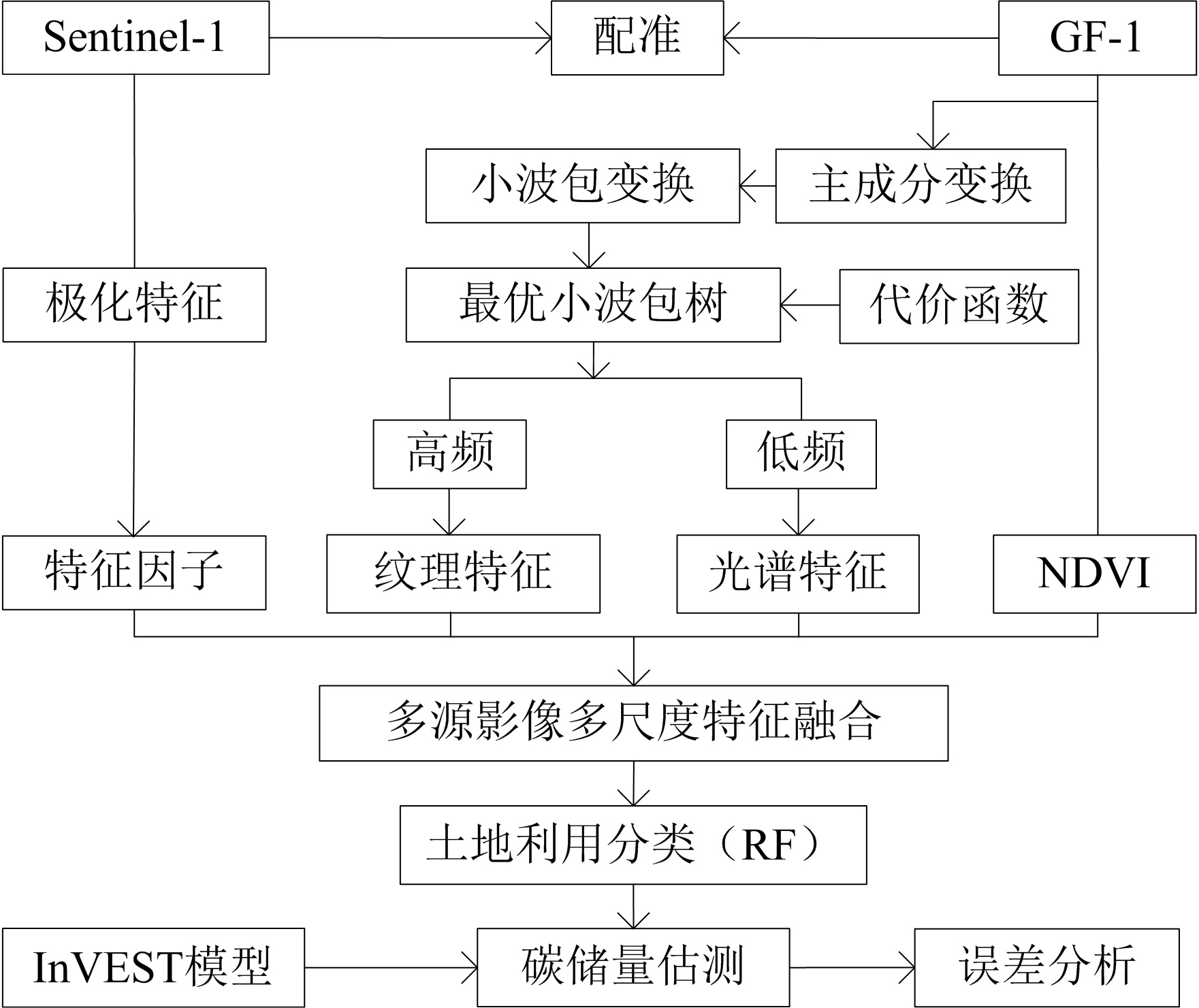
Figure 2 Carbon storage estimation process combining GF-1 multiscale features and Sentinel-1 structural features
| 影像 | 特征 | 遥感特征因子 |
|---|---|---|
| Sentinel-1 | 后向散射系数 | $V(\mathrm{VV}), V(\mathrm{VH}), V(\mathrm{VV} / \mathrm{VH}), V_{[(\mathrm{VH}-\mathrm{VV}) /(\mathrm{VH}+\mathrm{VV})]}$ |
Table 1 Remote sensing feature factors extracted from Sentinel-1 images
| 影像 | 特征 | 遥感特征因子 |
|---|---|---|
| Sentinel-1 | 后向散射系数 | $V(\mathrm{VV}), V(\mathrm{VH}), V(\mathrm{VV} / \mathrm{VH}), V_{[(\mathrm{VH}-\mathrm{VV}) /(\mathrm{VH}+\mathrm{VV})]}$ |
| 土地利用类型 | 碳密度/(t∙hm−2) | |||
|---|---|---|---|---|
| Cabove, i | Cbelow, i | Csoil, i | Cdead, i | |
| 林地 | 9.07 | 24.79 | 16.87 | 2.00 |
| 住宅 | 0.53 | 0.00 | 0.00 | 0.00 |
| 水域 | 2.80 | 0.00 | 0.01 | 0.00 |
| 耕地 | 1.22 | 17.26 | 11.52 | 0.00 |
| 道路 | 0.46 | 0.00 | 0.00 | 0.00 |
| 园地 | 7.55 | 18.50 | 10.61 | 4.50 |
| 其他 | 1.30 | 0.00 | 3.14 | 0.00 |
Table 2 Carbon density in the studied area
| 土地利用类型 | 碳密度/(t∙hm−2) | |||
|---|---|---|---|---|
| Cabove, i | Cbelow, i | Csoil, i | Cdead, i | |
| 林地 | 9.07 | 24.79 | 16.87 | 2.00 |
| 住宅 | 0.53 | 0.00 | 0.00 | 0.00 |
| 水域 | 2.80 | 0.00 | 0.01 | 0.00 |
| 耕地 | 1.22 | 17.26 | 11.52 | 0.00 |
| 道路 | 0.46 | 0.00 | 0.00 | 0.00 |
| 园地 | 7.55 | 18.50 | 10.61 | 4.50 |
| 其他 | 1.30 | 0.00 | 3.14 | 0.00 |
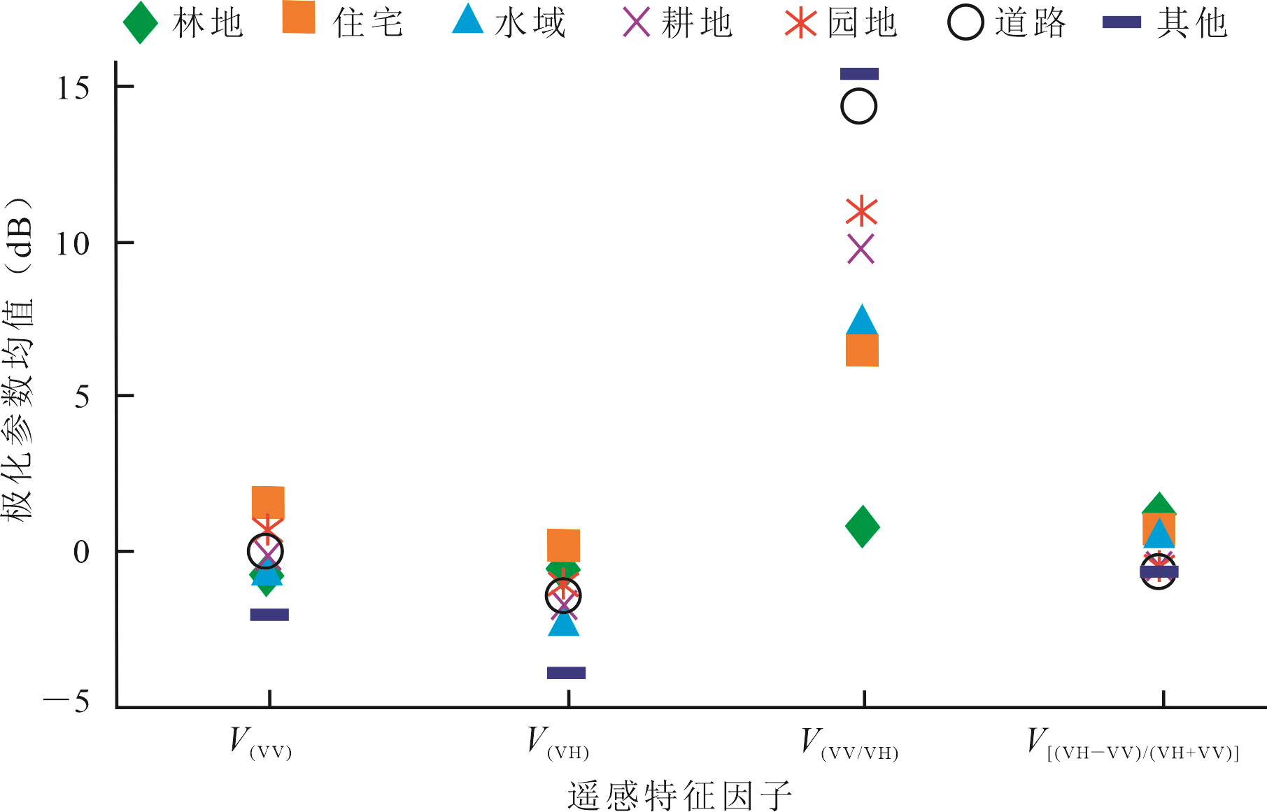
Figure 3 Differences of ground categories in SAR images
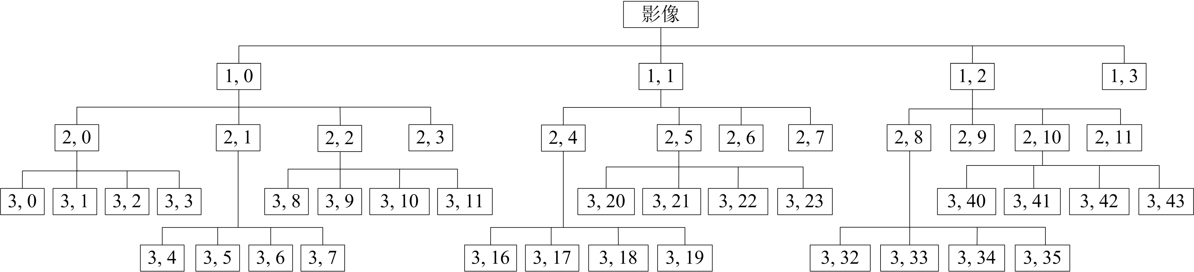
Figure 4 Optimal wavelet packet tree
| 节点号 | 节点熵值 | 节点号 | 节点熵值 | 节点号 | 节点熵值 |
|---|---|---|---|---|---|
| 1 | −26800.0 | 16 | −13.1 | 31 | −24.7 |
| 2 | −29200.0 | 17 | −2.6 | 32 | −3.3 |
| 3 | −100.0 | 18 | −32100.0 | 33 | −5.7 |
| 4 | −54.6 | 19 | −651.0 | 34 | −12.4 |
| 5 | −2.5 | 20 | −467.0 | 35 | −18.9 |
| 6 | −31100.0 | 21 | −102.0 | 36 | −3.9 |
| 7 | −316.0 | 22 | −118.0 | 37 | −5.2 |
| 8 | −190.0 | 23 | −148.0 | 38 | −16.9 |
| 9 | −22.2 | 24 | −18.6 | 39 | −3.2 |
| 10 | −55.1 | 25 | −34.1 | 40 | −12.9 |
| 11 | −40.2 | 26 | −80.7 | 41 | −4.1 |
| 12 | −3.7 | 27 | −15.9 | 42 | −2.7 |
| 13 | −4.3 | 28 | −71.5 | 43 | −1.1 |
| 14 | −36.8 | 29 | −23.4 | 44 | −6.8 |
| 15 | −4.0 | 30 | −22.1 | 45 | −2.7 |
Table 3 The entropy values of each node in the optimal tree
| 节点号 | 节点熵值 | 节点号 | 节点熵值 | 节点号 | 节点熵值 |
|---|---|---|---|---|---|
| 1 | −26800.0 | 16 | −13.1 | 31 | −24.7 |
| 2 | −29200.0 | 17 | −2.6 | 32 | −3.3 |
| 3 | −100.0 | 18 | −32100.0 | 33 | −5.7 |
| 4 | −54.6 | 19 | −651.0 | 34 | −12.4 |
| 5 | −2.5 | 20 | −467.0 | 35 | −18.9 |
| 6 | −31100.0 | 21 | −102.0 | 36 | −3.9 |
| 7 | −316.0 | 22 | −118.0 | 37 | −5.2 |
| 8 | −190.0 | 23 | −148.0 | 38 | −16.9 |
| 9 | −22.2 | 24 | −18.6 | 39 | −3.2 |
| 10 | −55.1 | 25 | −34.1 | 40 | −12.9 |
| 11 | −40.2 | 26 | −80.7 | 41 | −4.1 |
| 12 | −3.7 | 27 | −15.9 | 42 | −2.7 |
| 13 | −4.3 | 28 | −71.5 | 43 | −1.1 |
| 14 | −36.8 | 29 | −23.4 | 44 | −6.8 |
| 15 | −4.0 | 30 | −22.1 | 45 | −2.7 |
| 土地利用类型 | 样本均值与背景均值的马氏距离 | ||
|---|---|---|---|
| M1 | M2 | M3 | |
| 林地 | 45.12 | 155.96 | 34.78 |
| 住宅 | 90.79 | 94.88 | 67.89 |
| 水域 | 216.53 | 220.27 | 168.65 |
| 耕地 | 121.08 | 176.78 | 102.43 |
| 道路 | 86.82 | 71.02 | 55.88 |
| 园地 | 115.18 | 125.73 | 81.77 |
| 其他 | 34.34 | 79.61 | 52.65 |
Table 4 Separation degree between sample mean and background mean at each layer
| 土地利用类型 | 样本均值与背景均值的马氏距离 | ||
|---|---|---|---|
| M1 | M2 | M3 | |
| 林地 | 45.12 | 155.96 | 34.78 |
| 住宅 | 90.79 | 94.88 | 67.89 |
| 水域 | 216.53 | 220.27 | 168.65 |
| 耕地 | 121.08 | 176.78 | 102.43 |
| 道路 | 86.82 | 71.02 | 55.88 |
| 园地 | 115.18 | 125.73 | 81.77 |
| 其他 | 34.34 | 79.61 | 52.65 |
| 样本 | 林地 | 住宅 | 水域 | 耕地 | 道路 | 园地 | 其他 |
|---|---|---|---|---|---|---|---|
| 数量 | 29113 | 2816 | 1001 | 2674 | 845 | 2598 | 654 |
Table 5 Sample data sets
| 样本 | 林地 | 住宅 | 水域 | 耕地 | 道路 | 园地 | 其他 |
|---|---|---|---|---|---|---|---|
| 数量 | 29113 | 2816 | 1001 | 2674 | 845 | 2598 | 654 |
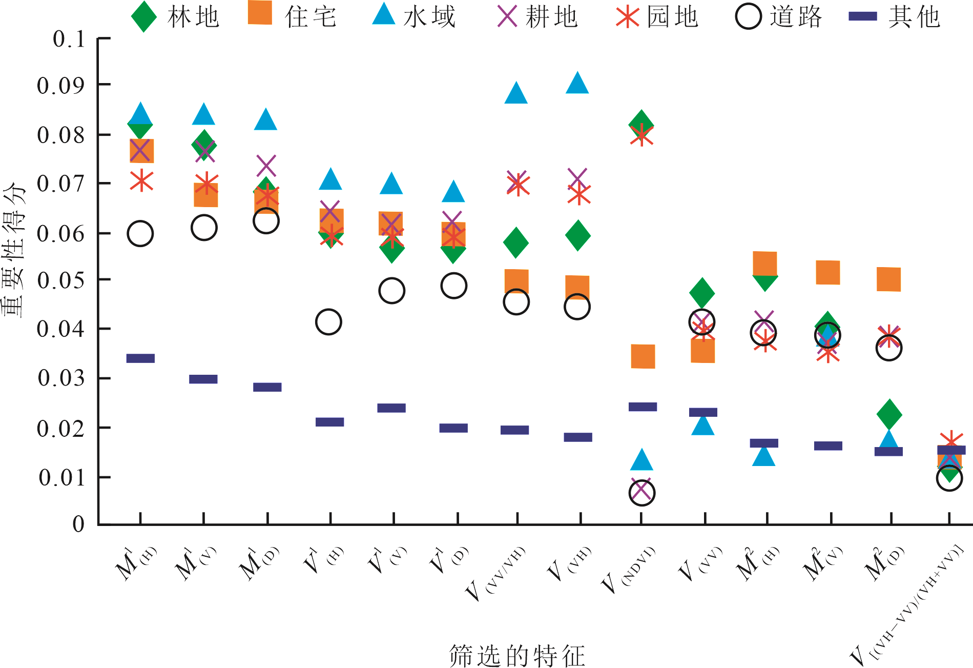
Figure 5 Ranking of feature importance

Figure 6 Classification results of land use
| 精度及Kappa系数 | 土地利用类型 | ||||||
|---|---|---|---|---|---|---|---|
| 林地 | 住宅 | 水域 | 耕地 | 园地 | 道路 | 其他 | |
| 生产者精度(PA)/% | 98.24 | 93.78 | 91.36 | 99.13 | 98.10 | 61.69 | 87.70 |
| 用户精度(UA)/% | 99.34 | 99.23 | 85.40 | 98.67 | 86.93 | 81.56 | 99.57 |
| 总体精度(OA)/% | 92.46 | ||||||
| Kappa系数 | 0.91 | ||||||
Table 6 Classification accuracy
| 精度及Kappa系数 | 土地利用类型 | ||||||
|---|---|---|---|---|---|---|---|
| 林地 | 住宅 | 水域 | 耕地 | 园地 | 道路 | 其他 | |
| 生产者精度(PA)/% | 98.24 | 93.78 | 91.36 | 99.13 | 98.10 | 61.69 | 87.70 |
| 用户精度(UA)/% | 99.34 | 99.23 | 85.40 | 98.67 | 86.93 | 81.56 | 99.57 |
| 总体精度(OA)/% | 92.46 | ||||||
| Kappa系数 | 0.91 | ||||||
| 土地利用类型 | 林地 | 住宅 | 耕地 | 水域 | 园地 | 道路 | 其他 |
|---|---|---|---|---|---|---|---|
| 林地 | 93.856 | 0.000 | 0.001 | 0.021 | 3.622 | 0.945 | 0.045 |
| 住宅 | 0.000 | 91.014 | 2.528 | 2.840 | 0.000 | 0.359 | 0.001 |
| 耕地 | 0.088 | 1.179 | 75.953 | 2.290 | 0.750 | 3.727 | 0.011 |
| 水域 | 0.045 | 6.453 | 6.831 | 83.123 | 0.068 | 8.857 | 0.079 |
| 园地 | 5.693 | 0.000 | 7.018 | 1.048 | 93.718 | 14.378 | 0.032 |
| 道路 | 0.001 | 0.173 | 1.245 | 4.121 | 0.601 | 67.895 | 0.001 |
| 其他 | 0.317 | 0.443 | 0.972 | 3.861 | 0.040 | 0.277 | 99.834 |
Table 7 Cumulative percentage of classification confusion
| 土地利用类型 | 林地 | 住宅 | 耕地 | 水域 | 园地 | 道路 | 其他 |
|---|---|---|---|---|---|---|---|
| 林地 | 93.856 | 0.000 | 0.001 | 0.021 | 3.622 | 0.945 | 0.045 |
| 住宅 | 0.000 | 91.014 | 2.528 | 2.840 | 0.000 | 0.359 | 0.001 |
| 耕地 | 0.088 | 1.179 | 75.953 | 2.290 | 0.750 | 3.727 | 0.011 |
| 水域 | 0.045 | 6.453 | 6.831 | 83.123 | 0.068 | 8.857 | 0.079 |
| 园地 | 5.693 | 0.000 | 7.018 | 1.048 | 93.718 | 14.378 | 0.032 |
| 道路 | 0.001 | 0.173 | 1.245 | 4.121 | 0.601 | 67.895 | 0.001 |
| 其他 | 0.317 | 0.443 | 0.972 | 3.861 | 0.040 | 0.277 | 99.834 |

Figure 7 Carbon storage statistical results based on G+W+S classification combined with InVEST model
| 不同遥感数据的碳储量估测法 | 碳储量/Tg | 误差/% |
|---|---|---|
| G | 32.23 | 3.90 |
| G+W | 32.01 | 3.19 |
| G+W+S | 31.27 | 0.81 |
Table 8 Comparison of carbon storage estimation errors for different remote sensing data
| 不同遥感数据的碳储量估测法 | 碳储量/Tg | 误差/% |
|---|---|---|
| G | 32.23 | 3.90 |
| G+W | 32.01 | 3.19 |
| G+W+S | 31.27 | 0.81 |
| 碳储量估测方法 | 碳储量/Tg | 误差/% |
|---|---|---|
| G+W+S | 31.27 | 0.81 |
| RF | 31.90 | 2.84 |
| KNN | 32.05 | 3.32 |
Table 9 Comparison with other carbon storage estimation models
| 碳储量估测方法 | 碳储量/Tg | 误差/% |
|---|---|---|
| G+W+S | 31.27 | 0.81 |
| RF | 31.90 | 2.84 |
| KNN | 32.05 | 3.32 |
| [1] |
ARÉVALO P, BACCINI A, WOODCOCK C E, et al., 2023. Continuous mapping of aboveground biomass using Landsat time series[J]. Remote Sensing of Environment, 288: 113483.
DOI URL |
| [2] |
CHEN G B, SUN Z W, ZHANG L, 2020. Road identification algorithm for remote sensing images based on wavelet transform and recursive opera tor[J]. IEEE Access, 8: 141824-141837.
DOI URL |
| [3] | CARCARRA-BES V, PARDINI M, CHOI C, et al., 2021. Tandem-X and Gedi Data Fusion for a Continuous Forest Height Mapping at Large Scales[J]. IEEE International Geoscience and Remote Sensing Symposium IGARSS, 2021: 796-799. |
| [4] | DONG L F, DU H Q, HAN N, et al., 2020. Application of convolutional neural network on lei bamboo Above-Ground-Bio-mass (AGB) estimation using worldview-2 [J]. Remote Sensing, 12(6): 958. |
| [5] | HONG D F, GAO L R, HANG R L, et al., 2022. Deep encoder-decoder networks for classification of hyperspectral and LiDAR data[J]. IEEE Geoscience and Remote Sensing Letters, 19: 1-5. |
| [6] |
LI Q S, WONG F, FUNG T, 2021. Mapping multi-layered mangroves from multispectral, hyperspectral, and LiDAR data[J]. Remote Sensing of Environment, 258(3): 112403.
DOI URL |
| [7] |
LECHNER M, DOSTÁLOVÁ A, HOLLAUS M, et al., 2022. Combination of Sentinel-1 and Sentinel-2 Data for tree species classification in a central european biosphere reserve[J]. Remote Sensing, 14(11): 2687.
DOI URL |
| [8] |
QIAN S, ZHOU Q B, WU W B, et al., 2017. Mapping regional cropping patterns by using GF-1 WFV sensor data[J]. Journal of Integrative Agriculture, 16(2): 337-347.
DOI URL |
| [9] |
QIN Y W, XIAO X M, WIGNERON J P, et al., 2022. Large loss and rapid recovery of vegetation cover and aboveground biomass over forest areas in Australia during 2019-2020[J]. Remote Sensing of Environment, 278: 113087.
DOI URL |
| [10] |
SANKAR A S, NAIR S S, DHARAN V S, et al., 2015. Wavelet sub band entropy based feature extraction method for BCI[J]. Procedia Computer Science, 46: 1476-1482.
DOI URL |
| [11] |
WANG L A, ZHOU X D, ZHU X K, et al., 2016. Estimation of biomass in wheat using random forest regression algorithm and remote sensing data[J]. The Crop Journal, 4(3): 212-219.
DOI URL |
| [12] |
WANG L N, SUN M C, LIU J H, et al., 2020. A robust algorithm based on phase congruency for optical and SAR image registration in suburban areas[J]. Remote Sensing, 12(20): 3339.
DOI URL |
| [13] |
YE Y X, BRUZZONE L, SHAN J, et al., 2019. Fast and robust matching for multimodal remote sensing image registration[J]. IEEE Transactions on Geoscience and Remote Sensing, 57(11): 9059-9070.
DOI URL |
| [14] |
ZHANG B, FU H Q, ZHU J J, et al., 2021. A multi-baseline PolInSAR forest height inversion model based on Fourier - Legendre polynomials[J]. IEEE Geoscience and Remote Sensing Letters, 18(4): 687-691.
DOI URL |
| [15] | 陈日东, 林什全, 潘国英, 等, 2019. 天堂山林场森林地上生物量及碳储量的遥感估算模型构建[J]. 林业与环境科学, 35(3): 71-77. |
| CHEN R D, LIN S Q, PAN G Y, et al., 2019. Remote sensing model for forest above-ground biomass and carbon storage in Tiantang Mountain forest farm[J]. Forestry and Environmental Science, 35(3): 71-77. | |
| [16] | 陈松, 孙华, 吴童, 等, 2020. 基于Sentinel-2与机载激光雷达数据的误差变量联立方程组森林蓄积量估测研究[J]. 中南林业科技大学学报, 40(12): 44-53. |
| CHEN S, SUN H, WU T, et al., 2020. Study on the forest volume inversion based on the simultaneous equations of error variables of Sentinel-2 and airborne Lidar data[J]. Journal of Central South University of Forestry and Technology, 40(12): 44-53. | |
| [17] | 邵壮, 陈然, 赵晶, 等, 2022. 基于FLUS与InVEST模型的北京市生态系统碳储量时空演变与预测[J]. 生态学报, 42(23): 59-72. |
| SHAO Z, CHEN R, ZHAO J, et al., 2022. Spatio-temporal evolution and prediction of carbon storage in Beijing’s ecosystem based on FLUS and InVEST models[J]. Acta Ecologica Sinica, 42(23): 59-72. | |
| [18] | 杨潋威, 赵娟, 朱家田, 等, 2022. 基于PLUS 和InVEST 模型的西安市生态系统碳储量时空变化与预测[J]. 自然资源遥感, 34(4): 175-182. |
| YANG L W, ZHAO J, ZHU J T, et al., 2022. Spatial and temporal variation and prediction of ecosystem carbon storage in Xi’an based on PLUS and InVEST model[J]. Remote Sensing for Natural Resources, 34(4): 175-182. | |
| [19] | 张丹丹, 肖晨超, 魏丹丹, 等, 2022. 基于时空谱的生态保护修复工程碳汇遥感监测技术框架研究[J]. 航天返回与遥感, 43(6): 119-128. |
| ZHANG D D, XIAO C C, WEI D D, et al., 2022. Study on the technical framework of carbon sink monitoring for ecological protection and restoration projects based on spatial-temporal-spectral data[J]. Spacecraft Recovery & Remote Sensing, 43(6): 119-128. | |
| [20] | 朱建华, 田宇, 李奇, 等, 2023. 中国森林生态系统碳汇现状与潜力[J]. 生态学报, 43(9) : 1-15. |
|
ZHU J H, TIAN Y, LI Q, et al., 2023. The current and potential carbon sink in forest ecosystem in China[J]. Acta Ecologica Sinica, 43(9): 1-15.
DOI URL |
|
| [21] | 朱宁宁, 杨必胜, 董震, 2025. 森林植被碳储量的遥感估测流程与方法[J]. 遥感学报, 29(1): 134-146. |
|
ZHU N N, YANG B S, DONG Z, 2025. A novel framework for forest vegetation carbon stock estimation based on remote sensing[J]. National Remote Sensing Bulletin, 29(1): 134-146.
DOI URL |
| [1] | WANG Yue, YU Fudong, ZHANG Yue, XIANG Hengxing, YAN Hengqi, MAO Dehua. Multi-scenario Simulation of Landscape Pattern and Carbon Storage Changes in Northeast Black Soil Region Based on the PLUS-InVEST Model [J]. Ecology and Environmental Sciences, 2026, 35(2): 178-189. |
| [2] | CUI Liyang, ZHANG Lei, JIA Xia, ZHAO Yonghua, MU Qi, SI Shaocheng. Soil Quality Assessment of Saline-alkali Land in Southern Xinjiang Combined with Ecosystem Services [J]. Ecology and Environmental Sciences, 2026, 35(2): 245-255. |
| [3] | TANG Zhongao, CHUN Zhenjie, DUAN Xingwu, ZHANG Ruihuan, RONG Li, LIU Wenxu. Simulated Effects of Erosion on Soil Microorganisms and Soil Organic Carbon [J]. Ecology and Environmental Sciences, 2026, 35(1): 54-61. |
| [4] | WANG Guolin, LIU Kaiying, SONG Ningning, LIU Jun, WANG Fangli, WANG Xuexia, ZONG Haiying, LI Shaojing. Response Mechanism of Organic Nitrogen Components in Saline-alkali Soil to the Input of Straw and Straw Biochar [J]. Ecology and Environmental Sciences, 2026, 35(1): 62-74. |
| [5] | GUAN Jinshun, JIANG Xinyu, CHENG Jiong, CHEN Sanxiong, YU Shiqin. Study on the Enhancement of Carbon and Nitrogen Retention in Rare Earth Tailings Soil by Microalgae [J]. Ecology and Environmental Sciences, 2025, 34(12): 1890-1899. |
| [6] | XIA Yining, LIU Peng’ao, HE Kerun, TIAN Chaohui, ZENG Liting, HOU Kelun. Spatiotemporal Dynamics and Scenario Simulations of Ecosystem Carbon Storage Based on Land Use Changes in the Changsha-Zhuzhou-Xiangtan Metropolitan Area [J]. Ecology and Environmental Sciences, 2025, 34(11): 1661-1674. |
| [7] | WANG Zongyang, ZENG Xuelan, ZHU Zhenchang, GUO Fen, LUO Lijuan, ZHANG Wuying, DU Qingping, ZHANG Yuan. Spatial Distribution and Driving Mechanisms of Vegetation and Soil Carbon Density in the Mangrove Ecosystem of Zhanjiang City [J]. Ecology and Environmental Sciences, 2025, 34(11): 1705-1714. |
| [8] | KONG Xiaoyun, ZHANG Yongkun, LI Runjie, LI Ying, LIN Chengqing, MA Zhanming, XIN Jilin, YANG Xiaoxuan, DANG Yile, ZHAO Jiayi, FENG Lingzheng, ZHOU Yan. Characteristics of Spatial Variation of Organic Carbon in Cultivated Soil Aggregates in Huangshui River Basin and Analysis of Its Driving Factors [J]. Ecology and Environmental Sciences, 2025, 34(11): 1715-1727. |
| [9] | CHEN Xinyi, MAO Yaruo, SONG Liangying, WANG Tongyao, LI Qiquan. Characteristics of Spatial Distribution of Total Phosphorus in Cropland Soils and Its Main Controlling Factors in the Sichuan Basin [J]. Ecology and Environmental Sciences, 2025, 34(10): 1569-1578. |
| [10] | CHEN Wentao, XIAO Xian, ZHANG Yi, FANG Guodong, TU Baohua, CHEN Ning. Generation Mechanism and Environmental Effects of Hydroxyl Radicals in Paddy Soil [J]. Ecology and Environmental Sciences, 2025, 34(10): 1654-1660. |
| [11] | LIU Qing, GONG Yushun, WANG Wei, FANG Xiantao, WU Jinshui, SHEN Jianlin. Spatio-temporal Characteristics of Soil Organic Carbon and Its Components in Typical tea Gardens in Hunan Province, China [J]. Ecology and Environmental Sciences, 2025, 34(9): 1386-1397. |
| [12] | WU Guiling, WU Xiaohui, OU Weiyou, ZHOU Huakun, MA Wenwen, JI Xiaofei. Study on the Distribution of Soil Salinity Ions in Typical Vegetation Communities of Salt Marsh Wetlands in the Qinghai Lake Basin [J]. Ecology and Environmental Sciences, 2025, 34(8): 1228-1239. |
| [13] | LI Man, WU Dongli, HE Hao, YU Huijie, ZHAO Lin, LIU Cong, HU Zhenghua, LI Qi. Spatio-temporal Evolution and Driving Factors of Carbon Storage in the Yellow River Basin from 1990 to 2020 [J]. Ecology and Environmental Sciences, 2025, 34(3): 333-344. |
| [14] | SHEN Jialong, WU Lihong, LI Linshuang, ZHOU Yuanfang, YANG Xiaomin. Effects of Land Uses on Soil Organic Carbon Fractions and Their Carbon Sequestration in a Typical Karst Small Mountain Watershed [J]. Ecology and Environmental Sciences, 2025, 34(3): 358-367. |
| [15] | HE Youwen, HAN Yafeng, WANG Xugang, SUN Lirong, XING Jiangbing, CAO Shengyuan. Differences in Drivers of Agricultural Wetland Soils Carbon Emissions under Contrasting Light Conditions [J]. Ecology and Environmental Sciences, 2025, 34(3): 391-400. |
| Viewed | ||||||
|
Full text |
|
|||||
|
Abstract |
|
|||||
Copyright © 2021 Editorial Office of ACTA PETROLEI SINICA
Address:No. 6 Liupukang Street, Xicheng District, Beijing, P.R.China, 510650
Tel: 86-010-62067128, 86-010-62067137, 86-010-62067139
Fax: 86-10-62067130
Email: syxb@cnpc.com.cn
Support byBeijing Magtech Co.ltd, E-mail:support@magtech.com.cn