Ecology and Environment ›› 2023, Vol. 32 ›› Issue (12): 2207-2215.DOI: 10.16258/j.cnki.1674-5906.2023.12.012
• Environment • Previous Articles Next Articles
HUANG Guofeng1( ), HE Bin2, XIE Zhiyi1, LIU Jun1, WANG Anhou1, LIAO Tong1, WANG Bojin1, HAO Beibei2,*()
Received:2023-06-12
Online:2023-12-18
Published:2024-02-05
Contact:
HAO Beibei
黄国锋1(), 贺斌2, 谢志宜1, 刘军1, 王安侯1, 廖彤1, 王博瑾1, 郝贝贝2,*()
通讯作者:
郝贝贝
作者简介:黄国锋(1974年生),男,高级工程师,研究方向为生态环境监测。E-mail: gdsthjt_huangguofeng@gd.gov.cn
基金资助:CLC Number:
HUANG Guofeng, HE Bin, XIE Zhiyi, LIU Jun, WANG Anhou, LIAO Tong, WANG Bojin, HAO Beibei. Impact of Agricultural Pollution on Water Environment and Its Spatial Differentiation pattern in Guangdong Province[J]. Ecology and Environment, 2023, 32(12): 2207-2215.
黄国锋, 贺斌, 谢志宜, 刘军, 王安侯, 廖彤, 王博瑾, 郝贝贝. 广东省农业源污染对水环境的影响及其空间分异格局[J]. 生态环境学报, 2023, 32(12): 2207-2215.
Add to citation manager EndNote|Ris|BibTeX
URL: https://www.jeesci.com/EN/10.16258/j.cnki.1674-5906.2023.12.012
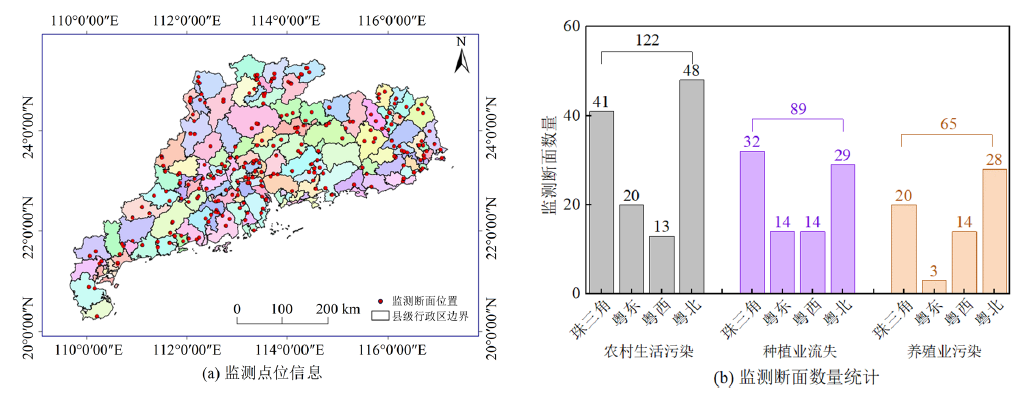
Figure 1 Distribution of agricultural and rural non-point source pollution monitoring sites in Guangdong Province
| 内梅罗综合污染指数Ii | 0‒1.0 | 1.0‒2.0 | 2.0‒3.0 | 3.0‒5.0 | ≥5.0 |
|---|---|---|---|---|---|
| 分类等级 | 清洁 | 轻度污染 | 污染 | 重污染 | 严重污染 |
Table 1 Classification standards for agricultural non-point source pollution
| 内梅罗综合污染指数Ii | 0‒1.0 | 1.0‒2.0 | 2.0‒3.0 | 3.0‒5.0 | ≥5.0 |
|---|---|---|---|---|---|
| 分类等级 | 清洁 | 轻度污染 | 污染 | 重污染 | 严重污染 |
| 水质指标 | 断面类型 | 区域 | 断面类型×区域 | ||||||||
|---|---|---|---|---|---|---|---|---|---|---|---|
| 自由度 | F值 | P值 | 自由度 | F值 | P值 | 自由度 | F值 | P值 | |||
| ρ(CODCr) | 2 | 2.420 | 0.089 | 3 | 52.488 | <0.001 | 6 | 4.429 | 0.000 | ||
| ρ(CODMn) | 2 | 0.245 | 0.783 | 3 | 41.793 | <0.001 | 6 | 2.479 | 0.022 | ||
| ρ(TN) | 2 | 2.228 | 0.108 | 3 | 56.380 | <0.001 | 6 | 1.812 | 0.094 | ||
| ρ(TP) | 2 | 0.458 | 0.633 | 3 | 35.441 | <0.001 | 6 | 1.256 | 0.276 | ||
| ρ(NH4+) | 2 | 6.484 | 0.002 | 3 | 18.244 | <0.001 | 6 | 1.678 | 0.123 | ||
| ρ(NO3−) | 2 | 0.458 | 0.633 | 3 | 35.441 | <0.001 | 6 | 1.256 | 0.276 | ||
| Ii | 2 | 2.724 | 0.066 | 3 | 61.436 | <0.001 | 6 | 3.564 | 0.002 | ||
Table 2 Two-way ANOVA results of water quality index and Nemerow integrated pollution index (Ii) in different regions and different monitoring sites
| 水质指标 | 断面类型 | 区域 | 断面类型×区域 | ||||||||
|---|---|---|---|---|---|---|---|---|---|---|---|
| 自由度 | F值 | P值 | 自由度 | F值 | P值 | 自由度 | F值 | P值 | |||
| ρ(CODCr) | 2 | 2.420 | 0.089 | 3 | 52.488 | <0.001 | 6 | 4.429 | 0.000 | ||
| ρ(CODMn) | 2 | 0.245 | 0.783 | 3 | 41.793 | <0.001 | 6 | 2.479 | 0.022 | ||
| ρ(TN) | 2 | 2.228 | 0.108 | 3 | 56.380 | <0.001 | 6 | 1.812 | 0.094 | ||
| ρ(TP) | 2 | 0.458 | 0.633 | 3 | 35.441 | <0.001 | 6 | 1.256 | 0.276 | ||
| ρ(NH4+) | 2 | 6.484 | 0.002 | 3 | 18.244 | <0.001 | 6 | 1.678 | 0.123 | ||
| ρ(NO3−) | 2 | 0.458 | 0.633 | 3 | 35.441 | <0.001 | 6 | 1.256 | 0.276 | ||
| Ii | 2 | 2.724 | 0.066 | 3 | 61.436 | <0.001 | 6 | 3.564 | 0.002 | ||
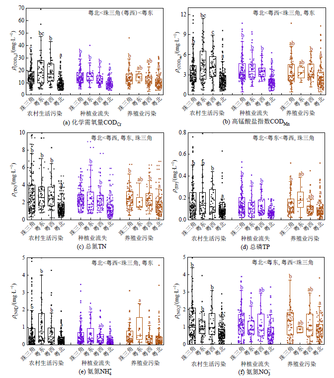
Figure 2 Comparison of water quality at agricultural and rural non-point source pollution monitoring sites in different regions of Guangdong Province
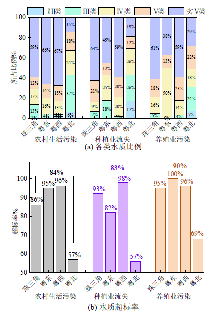
Figure 3 Water quality conditions at agricultural and rural monitoring sites in different regions of Guangdong Province
| 断面类型 | 珠三角 | 粤东 | 粤西 | 粤北 |
|---|---|---|---|---|
| 农村生活污染 | 3.04 | 2.17 | 1.84 | 0.36 |
| 种植业流失 | 1.42 | 1.39 | 1.46 | 0.35 |
| 养殖业污染 | 1.51 | 1.05 | 1.52 | 0.77 |
Table 3 Excessive multiples of TN in different regions and different monitoring sites
| 断面类型 | 珠三角 | 粤东 | 粤西 | 粤北 |
|---|---|---|---|---|
| 农村生活污染 | 3.04 | 2.17 | 1.84 | 0.36 |
| 种植业流失 | 1.42 | 1.39 | 1.46 | 0.35 |
| 养殖业污染 | 1.51 | 1.05 | 1.52 | 0.77 |
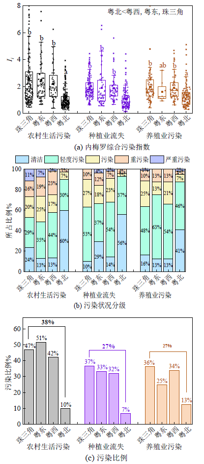
Figure 4 Pollution status of agricultural and rural monitoring sites in different regions of Guangdong Province
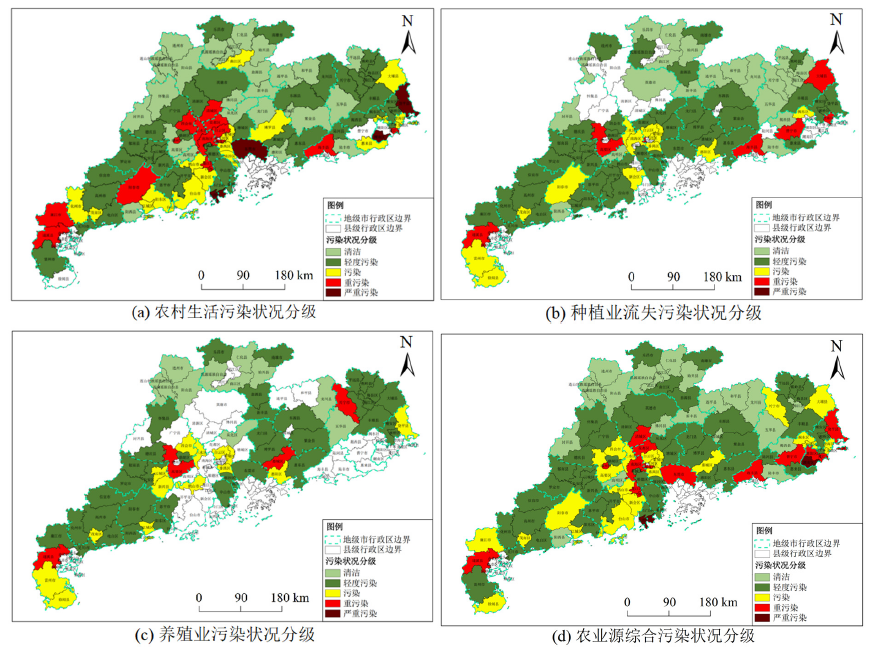
Figure 5 Classification of agricultural source pollution status in counties in Guangdong Province
| [1] |
ADU J T, KUMARASAMY M V, 2018. Assessing non-point source pollution models: A review[J]. Polish Journal of Environmental Studies, 27(5): 1913-1922.
DOI URL |
| [2] |
BOUWMAN L, GOLDEWIJK K K, VAN DER HOEK K W, et al., 2013. Exploring global changes in nitrogen and phosphorus cycles in agriculture induced by livestock production over the 1900-2050 period[J]. Proceedings of the National Academy of Sciences, 110(52): 20882-20887.
DOI URL |
| [3] |
BRYAN B A, JOHN M K, 2011. Designing a policy mix and sequence for mitigating agricultural non-point source pollution in a water supply catchment[J]. Water Resources Management, 25: 875-892.
DOI URL |
| [4] |
JIN G, LI Z H, DENG X Z, et al., 2019. An analysis of spatiotemporal patterns in Chinese agricultural productivity between 2004 and 2014[J]. Ecological Indicators, 105: 591-600.
DOI URL |
| [5] | JIN M, REN Z, SHI J P, et al., 2010. Impact of agricultural non-point source pollution in eutrophic-water body of Taihu Lake[J]. Environmental Science & Technology (China), 33(10): 106-119. |
| [6] |
MAO Y P, ZHANG H, TANG W Z, et al., 2021. Net anthropogenic nitrogen and phosphorus inputs in Pearl River Delta region (2008-2016)[J]. Journal of Environmental Management, 282: 111952.
DOI URL |
| [7] |
RUDRA R P, MEKONNEN B A, SHUKLA R, et al., 2020. Currents status, challenges, and future directions in identifying critical source areas for non-point source pollution in Canadian conditions[J]. Agriculture, 10(10): 468.
DOI URL |
| [8] |
WANG J L, LU J Z, ZHANG Z, et al., 2022. Agricultural non-point sources and their effects on chlorophyll-a in a eutrophic lake over three decades (1985-2020)[J]. Environmental Science and Pollution Research, 29(31): 46634-46648.
DOI |
| [9] |
XU K, WANG Y P, SU H, et al., 2013. Effect of land-use changes on nonpoint source pollution in the Xizhi River watershed, Guangdong, China[J]. Hydrological Processe, 27(18): 2557-66.
DOI URL |
| [10] |
ZHANG T, YANG Y H, NI J P, et al., 2019. Adoption behavior of cleaner production techniques to control agricultural non-point source pollution: A case study in the Three Gorges Reservoir Area[J]. Journal of Cleaner Production, 223: 897-906.
DOI URL |
| [11] |
ZOU L L, LIU Y S, WANG Y S, et al., 2020. Assessment and analysis of agricultural non-point source pollution loads in China: 1978-2017[J]. Journal of Environmental Management, 263: 110400.
DOI URL |
| [12] | 曹佳霖, 胡茂川, 贺凯, 等, 2023. 广东省农业面源污染现状及变化的多尺度评价[J]. 生态与农村环境学报, 39(7): 924-933. |
| CAO J L, HU M C, HE K, et al., 2023. Multi-scale assessment of agricultural non-point source pollution loadings and its changing characteristics in Guangdong Province[J]. Journal of Ecology and Rural Environment, 39(7): 924-933. | |
| [13] |
邓玉娇, 王捷纯, 徐杰, 等, 2022. 广东省植被固碳量时空变化及气象贡献率研究[J]. 生态环境学报, 31(1): 1-8.
DOI |
| DENG Y J, WANG J C, XU J, et al., 2022. Spatiotemporal variation of vegetation carbon sequestration and its meteorological contribution in Guangdong Province[J]. Ecology and Environmental Sciences, 31(1): 1-8. | |
| [14] |
冯亚芬, 俞万源, 雷汝林, 2017. 广东省传统村落空间分布特征及影响因素研究[J]. 地理科学, 37(2): 236-243.
DOI |
|
FENG Y F, YU W Y, LEI R L, 2017. Spatial distribution features and controlling factors of traditional villages in Guangdong Province[J]. Scientia Geographica Sinica, 37(2): 236-243.
DOI |
|
| [15] | 葛小君, 黄斌, 袁再健, 等, 2022. 近20年来广东省农业面源污染负荷时空变化与来源分析[J]. 环境科学, 43(6): 3118-3127. |
| GE X J, HUANG B, YUAN Z J, et al., 2022. Temporal and spatial variation characteristics and source analysis of agricultural non-point source pollution load in Guangdong during the past 20 years[J]. Environment Science, 43(6): 3118-3127. | |
| [16] |
贺斌, 胡茂川, 2022. 广东省各区县农业面源污染负荷估算及特征分析[J]. 生态环境学报, 31(4): 771-776.
DOI |
| HE B, HU M C, 2022. Evaluation of agriculture non-point pollution load and its characteristics in all districts and counties of Guangdong[J]. Ecology and Environmental Sciences, 31(4): 771-776. | |
| [17] |
林兰稳, 朱立安, 曾清苹, 2020. 广东省农业面源污染时空变化及其防控对策[J]. 生态环境学报, 29(6): 1245-1250.
DOI |
| LIN L W, ZHU L A, CAO Q P, 2020. Spatial and temporal changes of agricultural non-point source pollution in Guangdong province and its prevention and control measures[J]. Ecology and Environmental Sciences, 29(6): 1245-1250. | |
| [18] | 刘丽辉, 辛焕平, 2018. 粮食安全与农业结构调整水平的协整分析——以广东省为例[J]. 中国农业资源与区划, 39(10): 23-29. |
| LIU L H, XIN H P, 2018. Co-integration analysis of grain security and agricultural structure adjustment: Taking Guangdong as an example[J]. Chinese Journal of Agricultural Resources and Regional Planning, 39(10): 23-29. | |
| [19] | 刘明庆, 陈秋会, 杨育文, 等, 2021. 发展有机农业控制面源污染的实践与对策[J]. 环境与可持续发展, 46(6): 98-104. |
| LIU M Q, CHEN Q H, YANG Y W, et al., 2021. Practice and countermeasures of developing organic agriculture to control non-point source pollution[J]. Environment and Sustainable Development, 46(6): 98-104. | |
| [20] | 丘雯文, 钟涨宝, 原春辉, 等, 2018. 中国农业面源污染排放的空间差异及其动态演变[J]. 中国农业大学学报, 23(1): 152-163. |
| QIU W W, ZHONG Z B, YUAN C H, et al., 2018. Spatial differences and dynamic evolution of agricultural non-point source pollution in China[J]. ournal of China Agricultural University, 23(1): 152-163. | |
| [21] | 宋欢, 2013. 广东农村生活环境分析及对策研究[J]. 广东农业科学, 40(8): 161-164. |
| SONG H, 2013. Analysis and countermeasures of Guangdong rural living environment[J]. Guangdong Agricultural Sciences, 40(8): 161-164. | |
| [22] | 王楠, 郝贝贝, 张思毅, 等, 2023. 1991-2021年广东省农业面源污染源特征分析[J]. 农业工程学报, 39(9): 190-200. |
| WANG N, HAO B B, ZHANG S Y, et al., 2023. Agricultural non-point source pollution in Guangdong Province of China from 1991 to 2021[J]. Transactions of the Chinese Society of Agricultural Engineering, 39(9): 190-200. | |
| [23] | 夏丽佳, 余慕琴, 严萌, 等, 2021. 珠三角四市农业面源污染源解析与评价[J]. 人民珠江, 42(5): 35-41. |
| XIA L J, YU M Q, YAN M, et al., 2021. Analysis and evaluation of agricultural non-point source pollution sources in four cities in the Pearl River Delta[J]. Pearl River, 42(5): 35-41. | |
| [24] | 熊凡, 林晓君, 曾经文, 等, 2018. 广州市农业面源污染概况及特征分析[J]. 广东农业科学, 45(3): 81-87. |
| XIONG F, LIN X J, ZENG J W, et al., 2018. Overview and feature analysis of agricultural non-point source pollution in Guangzhou[J]. Guangdong Agricultural Sciences, 45(3): 81-87. | |
| [25] | 杨滨键, 尚杰, 于法稳, 2019. 农业面源污染防治的难点、问题及对策[J]. 中国生态农业学报, 27(2): 236-245. |
| YANG B J, SHANG J, YU F W, 2019. Difficulty, problems and countermeasures of agricultural non-point sources pollution control in China[J]. Chinese Journal of Eco-Agriculture, 27(2): 236-245. | |
| [26] | 杨林章, 冯彦房, 施卫明, 等, 2013. 我国农业面源污染治理技术研究进展[J]. 中国生态农业学报, 21(1): 96-101. |
| YANG L Z, FENG Y F, SHI W M, et al., 2013. Review of the advances and development trends in agricultural non-point source pollution control in China[J]. Chinese Journal of Eco-Agriculture, 21(1): 96-101. | |
| [27] | 杨林章, 吴永红, 2018. 农业面源污染防控与水环境保护[J]. 中国科学院院刊, 33(2): 168-176. |
| YANG L Z, WU Y H, 2018. Prevention and control of agricultural non-point source pollution and aquatic environmental protection[J]. Bulletin of Chinese Academy of Sciences, 33(2): 168-176. | |
| [28] | 叶延琼, 章家恩, 李逸勉, 等, 2013. 基于GIS的广东省农业面源污染的时空分异研究[J]. 农业环境科学学报, 32(2): 369-377. |
| YE Y Q, ZHANG J E, LI Y M, et al., 2013. Spatial-temporal variation of agricultural non-point source pollution based on GIS technology in Guangdong province, China[J]. Journal of Agro-Environment Science, 32(2): 369-377. | |
| [29] | 中国环境监测总站, 2022. 农村环境质量综合评价技术规定(修订征求意见稿)[S]. |
| China National Environmental Monitoring Centre,2022. Technical provisions on comprehensive assessment of rural environmental quality (Revised Draft for Comments)[S]. | |
| [30] | 中国国家环境保护总局,2002. 地表水环境质量标准: GB 3838—2002[S]. |
| PRC State Environmental Protection Administration,2022. Surface water environmental quality standards: GB 3838—2002[S]. |
| [1] | QIAN Haiming, ZHANG Yunlin, LI Na, WANG Weijia, SUN Xiao, ZHANG Yibo, SHI Kun, FENG Sheng, GAO Yanghui. High Frequency Monitoring of Water Quality Dynamics for River Drinking Water Source during the Typical Rainfall Process [J]. Ecology and Environment, 2023, 32(3): 579-589. |
| [2] | XU Ming, ZHANG Fuying, SUN Lulu, ZHOU Zengxing, LIN Chaoba, ZHU Xuezhu. Pollution Characteristics, Source Analysis and Correlation of Biological Factors of Polycyclic Aromatic Hydrocarbons in Soils of Industrial Areas in Beijing-Tianjin-Hebei Region [J]. Ecology and Environment, 2023, 32(11): 1952-1963. |
| [3] | WU Haoping, QIN Hongjie, HE Bin, YOU Yi, CHEN Jinfeng, ZOU Chunping, YANG Siyu, HAO Beibei. A Brief Discussion on the Development Trend of the Agricultural Non-point Source Pollution Control Model Based on Carbon Neutrality [J]. Ecology and Environment, 2022, 31(9): 1919-1926. |
| [4] | SHI Wenjing, ZHOU Hanpeng, SUN Tao, HUANG Jintao, YANG Wenhuan, LI Weiping. Research on Priority Control Factors and Health Risk Assessment of Heavy Metal Pollution in Soil Around Mining Areas [J]. Ecology and Environment, 2022, 31(8): 1616-1628. |
| [5] | ZHU Li, YAN Huaizhong, SUN Youmin, FAN Jing, LIU Guanghui, ZHNG Guiqin. Characteristics and Source Identification of Dust Precipitates in A Typical Heavy Industry Area in Shandong [J]. Ecology and Environment, 2022, 31(7): 1393-1399. |
| [6] | SHI Jianfei, JIN Zhengzhong, ZHOU Zhibin, WANG Xin. Evaluation of Heavy Metal Pollution in the Soil Around A Typical Tailing Reservoir in Irtysh River Basin [J]. Ecology and Environment, 2022, 31(5): 1015-1023. |
| [7] | REN Lijiang, ZHANG Yan, ZHANG Xin, SHAN Zexuan, ZHANG Chengqian. Pollution Characteristics and Health Risk Assessment of Heavy Metals in Surface Water in Guanzhong Section of the Weihe River Basin [J]. Ecology and Environment, 2022, 31(1): 131-141. |
| [8] | ZHANG Ping, FANG Chun, ZHU Sihan, HAN Song, LI Kai, WANG Zhikang. Optimization of Microalgae Species and Nitrogen and Phosphorus Conversion for Domestic Sewage Treatment [J]. Ecology and Environment, 2021, 30(8): 1706-1715. |
| [9] | SHI Huibin, HUANG Yi, CHENG Xin, LI Ting, HE Min, WANG Jinjin. Pollution Characteristics and Sources of Carbonaceous Components in PM2.5 during Winter in Chengdu [J]. Ecology and Environment, 2021, 30(7): 1420-1427. |
| [10] | TA Weiyuan, KANG Zhen, MENG Zhaojun, JIN Shenghua, YANG Xing, GUO Longfei, ZHAO Dongxu, ZHANG Xin. Research of Pollution Characteristics of Heavy Metals in Soil of Typical Closed Zinc Smelting Enterprises in Qinling Mountains [J]. Ecology and Environment, 2021, 30(7): 1513-1521. |
| Viewed | ||||||
|
Full text |
|
|||||
|
Abstract |
|
|||||
Copyright © 2021 Editorial Office of ACTA PETROLEI SINICA
Address:No. 6 Liupukang Street, Xicheng District, Beijing, P.R.China, 510650
Tel: 86-010-62067128, 86-010-62067137, 86-010-62067139
Fax: 86-10-62067130
Email: syxb@cnpc.com.cn
Support byBeijing Magtech Co.ltd, E-mail:support@magtech.com.cn