
生态环境学报 ›› 2026, Vol. 35 ›› Issue (7): 1072-1082.DOI: 10.16258/j.cnki.1674-5906.2026.07.008
何杰霞1,2,3,4( ), 张福庆1,2,3,*(), 辛雪1,2,3
收稿日期:2025-12-08
修回日期:2026-04-02
接受日期:2026-04-26
出版日期:2026-07-18
发布日期:2026-07-17
通讯作者:
*张福庆,202260001@ecut.edu.cn
作者简介:何杰霞(2002年生),女,硕士研究生,主要从事土地利用与景观生态研究。E-mail: hejiexia2002@126.com
基金资助:
He Jiexia1,2,3,4(), Zhang Fuqing1,2,3,*(), Xin Xue1,2,3
Received:2025-12-08
Revised:2026-04-02
Accepted:2026-04-26
Online:2026-07-18
Published:2026-07-17
摘要:
提升生态安全预警信号的识别精度、构建符合地域特征的生态安全格局,是保障区域可持续发展的迫切需求。以鄱阳湖流域为研究区,运用确定性系数法与CNN-LSTM模型进行生态安全预警评估,并结合MSPA与电路理论识别生态源地、廊道及关键节点。进一步耦合PLUS模型的多情景模拟结果开展空间叠加分析,从而面向未来发展趋势划定优先保护与修复区域,最终构建生态安全格局。结果表明:1)CNN-LSTM模型在生态安全预警评估中展现出良好的预测能力和较高的预测精度,预警结果呈现出“南高北低”的空间分异特征;2)共识别生态源地26405 km2、11条关键生态廊道、18条重要生态廊道、149个生态夹点与968个生态障碍点;3)基于PLUS模型模拟2030年惯性发展、经济发展优先、生态保护优先及耕地保护优先等4种情景,结合生态网络要素分布识别出优先保护区97个、优先修复区457个,最终构建“五域三带多点”的生态安全格局。研究结果可为快速变化环境下的国土空间布局提供生态风险预警与管理情景预测,支撑流域生态安全与可持续发展目标的实现。
中图分类号:
何杰霞, 张福庆, 辛雪. 耦合预警与多情景模拟的生态安全格局构建——以鄱阳湖流域为例[J]. 生态环境学报, 2026, 35(7): 1072-1082.
He Jiexia, Zhang Fuqing, Xin Xue. Construction of Ecological Security Pattern Coupled with Early Warning and Multi-Scenario Simulation: A Case Study of the Poyang Lake Basin[J]. Ecology and Environmental Sciences, 2026, 35(7): 1072-1082.

图1 鄱阳湖流域区位图 本图基于审图号为GS(2019)1822号的标准地图制作;底图边界无修改
Figure 1 Location map of the Poyang Lake Basin
| 数据 名称 | 空间分辨率 | 数据 来源 |
|---|---|---|
| 高程 | 30 m | 地理空间数据云( |
| 归一化植被指数 | 1 km | 美国国家航空航天局( |
| 生态风险脆弱区 | - | ArcGIS Online中2021年Mapserver服务产品 |
| 气象数据 | 1 km | 国家青藏高原数据中心( |
| PM2.5 | 1 km | 国家青藏高原数据中心( |
| 土地利用数据 | 30 m | 中国逐年土地覆盖数据( |
| 人口密度数据 | 1 km | ORNL( |
| 夜间灯光数据 | 500 m | 全球类NPP-VIIRS的长时序夜间光照数据( |
| 水系数据 | - | OSM( |
| 道路数据 | - | OSM( |
| 水质数据 | - | 逐月高分辨率水质数据( |
| 自然保护区数据 | - | 江西省国土空间调查规划研究院 |
| 水位数据 | - | 国家冰川冻土沙漠科学数据中心( |
表1 数据来源
Table1 Data sources
| 数据 名称 | 空间分辨率 | 数据 来源 |
|---|---|---|
| 高程 | 30 m | 地理空间数据云( |
| 归一化植被指数 | 1 km | 美国国家航空航天局( |
| 生态风险脆弱区 | - | ArcGIS Online中2021年Mapserver服务产品 |
| 气象数据 | 1 km | 国家青藏高原数据中心( |
| PM2.5 | 1 km | 国家青藏高原数据中心( |
| 土地利用数据 | 30 m | 中国逐年土地覆盖数据( |
| 人口密度数据 | 1 km | ORNL( |
| 夜间灯光数据 | 500 m | 全球类NPP-VIIRS的长时序夜间光照数据( |
| 水系数据 | - | OSM( |
| 道路数据 | - | OSM( |
| 水质数据 | - | 逐月高分辨率水质数据( |
| 自然保护区数据 | - | 江西省国土空间调查规划研究院 |
| 水位数据 | - | 国家冰川冻土沙漠科学数据中心( |

图2 技术路线图
Figure 2 Technical roadmap
| 阻力因子 | 阻力值 | 权重 | ||||
|---|---|---|---|---|---|---|
| 1 | 2 | 3 | 4 | 5 | ||
| 土地利用类型 | 森林 | 草地,水体,灌木 | 农田 | 裸地 | 不透水地面 | 0.285 |
| 归一化植被指数 | [−0.2, 0.25) | [0.25, 0.5) | [0.5, 0.6) | [0.6, 0.7) | >0.8 | 0.006 |
| 坡度/° | [0, 1.5) | [1.5, 3.5) | [3.5, 6.5) | [6.5, 10) | >10 | 0.225 |
| 高程/m | [−80, 146) | [146, 321) | [321, 549) | [549, 900) | ≥900 | 0.169 |
| 距道路距离/m | [0, 600) | [600, 1200) | [1200, 2500) | [2500, 5000] | ≥5000 | 0.315 |
表2 阻力因子赋值及其权重
Table 2 Resistance factor assignments and their weights
| 阻力因子 | 阻力值 | 权重 | ||||
|---|---|---|---|---|---|---|
| 1 | 2 | 3 | 4 | 5 | ||
| 土地利用类型 | 森林 | 草地,水体,灌木 | 农田 | 裸地 | 不透水地面 | 0.285 |
| 归一化植被指数 | [−0.2, 0.25) | [0.25, 0.5) | [0.5, 0.6) | [0.6, 0.7) | >0.8 | 0.006 |
| 坡度/° | [0, 1.5) | [1.5, 3.5) | [3.5, 6.5) | [6.5, 10) | >10 | 0.225 |
| 高程/m | [−80, 146) | [146, 321) | [321, 549) | [549, 900) | ≥900 | 0.169 |
| 距道路距离/m | [0, 600) | [600, 1200) | [1200, 2500) | [2500, 5000] | ≥5000 | 0.315 |
| 土地利用类型 | 耕地 | 林地 | 草地 | 水域 | 建设用地 | 未利用地 |
|---|---|---|---|---|---|---|
| 耕地 | 1 | 1 | 1 | 1 | 1 | 1 |
| 林地 | 1 | 1 | 1 | 1 | 1 | 1 |
| 草地 | 1 | 1 | 1 | 1 | 1 | 1 |
| 水域 | 1 | 1 | 1 | 1 | 1 | 1 |
| 建设用地 | 0 | 0 | 0 | 0 | 1 | 0 |
| 未利用地 | 1 | 1 | 1 | 1 | 1 | 1 |
表3 土地利用类型转移矩阵
Table 3 Land use type transfer matrix
| 土地利用类型 | 耕地 | 林地 | 草地 | 水域 | 建设用地 | 未利用地 |
|---|---|---|---|---|---|---|
| 耕地 | 1 | 1 | 1 | 1 | 1 | 1 |
| 林地 | 1 | 1 | 1 | 1 | 1 | 1 |
| 草地 | 1 | 1 | 1 | 1 | 1 | 1 |
| 水域 | 1 | 1 | 1 | 1 | 1 | 1 |
| 建设用地 | 0 | 0 | 0 | 0 | 1 | 0 |
| 未利用地 | 1 | 1 | 1 | 1 | 1 | 1 |
| 参数 | 土地利用类型 | |||||
|---|---|---|---|---|---|---|
| 耕地 | 林地 | 草地 | 水域 | 建设用地 | 未利用地 | |
| 权重 | 0.155 | 0.055 | 0.452 | 0.585 | 0.895 | 0.219 |
表4 邻域权重参数
Table 4 Neighborhood weight parameters
| 参数 | 土地利用类型 | |||||
|---|---|---|---|---|---|---|
| 耕地 | 林地 | 草地 | 水域 | 建设用地 | 未利用地 | |
| 权重 | 0.155 | 0.055 | 0.452 | 0.585 | 0.895 | 0.219 |

图3 基于CNN-LSTM的生态安全预警评估
Figure 3 Ecological security early-warning assessment based on CNN-LSTM

图4 基于MSPA的生态源地识别
Figure 4 Identification of ecological sources based on MSPA
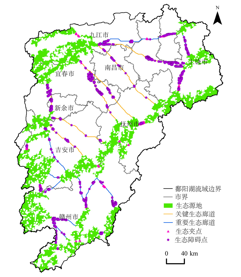
图5 鄱阳湖流域生态网络构建
Figure 5 Construction of ecological network in Poyang Lake Basin
| 土地利用类型 | NDS | CPS | EDS | EPS | |||||||
|---|---|---|---|---|---|---|---|---|---|---|---|
| 占比/% | 面积/km2 | 占比/% | 面积/km2 | 占比/% | 面积/km2 | 占比/% | 面积/km2 | ||||
| 耕地 | 26.21 | 42512.62 | 26.70 | 43307.4 | 25.98 | 42139.56 | 26.43 | 42869.46 | |||
| 林地 | 60.78 | 98585.16 | 60.80 | 98617.6 | 60.66 | 98390.52 | 60.90 | 98779.8 | |||
| 草地 | 4.47 | 7250.34 | 4.43 | 7185.46 | 4.46 | 7234.12 | 4.49 | 7282.78 | |||
| 水域 | 4.29 | 6958.38 | 4.25 | 6893.5 | 4.28 | 6942.16 | 4.29 | 6958.38 | |||
| 建设用地 | 3.93 | 6374.46 | 3.50 | 5677 | 4.30 | 6974.6 | 3.57 | 5790.54 | |||
| 未利用地 | 0.32 | 519.04 | 0.32 | 519.04 | 0.32 | 519.04 | 0.32 | 519.04 | |||
| 合计 | 100 | 162200 | 100 | 162200 | 100 | 162200 | 100 | 162200 | |||
表5 多情景下鄱阳湖流域各土地利用类型占比及面积
Table 5 Proportion and area of each land use type in the Poyang Lake Basin under multiple scenarios
| 土地利用类型 | NDS | CPS | EDS | EPS | |||||||
|---|---|---|---|---|---|---|---|---|---|---|---|
| 占比/% | 面积/km2 | 占比/% | 面积/km2 | 占比/% | 面积/km2 | 占比/% | 面积/km2 | ||||
| 耕地 | 26.21 | 42512.62 | 26.70 | 43307.4 | 25.98 | 42139.56 | 26.43 | 42869.46 | |||
| 林地 | 60.78 | 98585.16 | 60.80 | 98617.6 | 60.66 | 98390.52 | 60.90 | 98779.8 | |||
| 草地 | 4.47 | 7250.34 | 4.43 | 7185.46 | 4.46 | 7234.12 | 4.49 | 7282.78 | |||
| 水域 | 4.29 | 6958.38 | 4.25 | 6893.5 | 4.28 | 6942.16 | 4.29 | 6958.38 | |||
| 建设用地 | 3.93 | 6374.46 | 3.50 | 5677 | 4.30 | 6974.6 | 3.57 | 5790.54 | |||
| 未利用地 | 0.32 | 519.04 | 0.32 | 519.04 | 0.32 | 519.04 | 0.32 | 519.04 | |||
| 合计 | 100 | 162200 | 100 | 162200 | 100 | 162200 | 100 | 162200 | |||

图6 鄱阳湖流域多情景土地利用类型
Figure 6 Multi-scenario land use types in the Poyang Lake Basin

图7 鄱阳湖流域生态安全格局
Figure 7 Ecological security pattern of Poyang Lake Basin
| [1] |
Nie W B, Xu B, Ma S, et al., 2022. Coupling an ecological network with multi-scenario land use simulation: an ecological spatial constraint approach[J]. Remote Sensing, 14(23): 6099.
DOI URL |
| [2] |
Wei W J, Wang N, Yin L X, et al., 2024. Spatio-temporal evolution characteristics and driving mechanisms of Urban-Agricultural-Ecological space in ecologically fragile areas: a case study of the upper reaches of the Yangtze River Economic Belt, China[J]. Land Use Policy, 145: 107282.
DOI URL |
| [3] | 曹刚, 刘艳中, 张祚, 等, 2022. 土地生态安全二维预警模型构建及应用——以临湘市为例[J]. 中国环境科学, 42(5): 2305-2314. |
| Cao G, Liu Y Z, Zhang Z, et al., 2022. Construction and application of two-dimensional early warning model for land ecological security: A case study of Linxiang[J]. China Environmental Science, 42(5): 2305-2314. | |
| [4] | 陈月娇, 李祥, 王月健, 等, 2023. 尺度整合视角下伊犁河谷地区生态安全格局构建——以昭苏县为例[J]. 生态学报, 43(19): 8181-8192. |
| Chen Y J, Li X, Wang Y J, et al., 2023. Construction of ecological security pattern in the Ili River Valley from the perspective of scale integration: A case study of Zhaosu County[J]. Acta Ecologica Sinica, 43(19): 8181-8192. | |
| [5] | 段龙, 鄢天荥, 王江丽, 等, 2021. 结合高光谱成像和机器学习的棉种年份鉴别[J]. 光谱学与光谱分析, 41(12): 3857-3863. |
| Duan L, Yan T Y, Wang J L, et al., 2021. Identification of cotton seed years by combining hyperspectral imaging and machine learning[J]. Spectroscopy and Spectral Analysis, 41(12): 3857-3863. | |
| [6] | 都瓦莲, 2023. 基于情景模拟的东辽河流域生态安全预警研究[D]. 长春: 东北师范大学. |
| Du W L, 2023. Study on early warning of ecological security in East Liaohe River basin based on scenario simulation[D]. Changchun: Northeast Normal University. | |
| [7] | 段鹏, 陈文波, 杨欢, 等, 2024. 生境破碎化过程对流域生境质量的影响与交互作用[J]. 生态学报, 44(14): 6053-6066. |
| Duan P, Chen W B, Yang H, et al., 2024. Influence and interactions of habitat fragmentation processes on habitat quality in watersheds[J]. Acta Ecologica Sinica, 44(14): 6053-6066. | |
| [8] | 窦占宁, 王彬, 周金星, 2025. 基于机器学习的土壤侵蚀空间分布预报及影响因子分析——以西南高山峡谷区云南省云龙县为例[J]. 生态学报, 45(14): 1-15. |
| Dou Z N, Wang B, Zhou J X, 2025. Prediction of soil erosion spatial distribution and analysis of influencing factors using machine learning: A case study of Yunlong County of Yunnan Province in the alpine canyon region of Southwest China[J]. Acta Ecologica Sinica, 45(14): 1-15. | |
| [9] | 黄秋淞, 何浩, 塞尔江·哈力克, 等 2025. 基于多情景模拟的生态系统服务安全格局识别与优化——以塔里木河流域为例[J]. 生态学报, 45(23): 11476-11490. |
| Huang Q S, He H, Saierjiang H, et al., 2025. Identification and optimization of ecosystem service security patterns based on multi-scenario simulation: a case study of the Tarim River Basin[J]. Acta Ecologica Sinica, 45(23): 11476-11490. | |
| [10] | 柯小玲, 王晨曦, 郭海湘, 等, 2021. 基于系统动力学的长江经济带生态安全预警研究[J]. 长江流域资源与环境, 30(12): 2905-2914. |
| Ke X L, Wang C X, Guo H X, et al., 2021. Study on ecological security early warning of Yangtze River economic belt based on system dynamics[J]. Resources and Environment in the Yangtze Basin, 30(12): 2905-2914. | |
| [11] | 康文鸿, 贾夏, 赵永华, 等, 2026. 基于InVEST-CF耦合模型的秦岭北麓国土空间修复区域识别[J]. 生态学报, 46(1): 285-298. |
| Kang W H, Jia X, Zhao Y H, et al., 2026. Identification of land space restoration areas in the northern foothills of the Qinling Mountains based on the InVEST-CF coupled model[J]. Acta Ecologica Sinica, 46(1): 285-298. | |
| [12] |
李瑞发, 崔旺来, 司凌涵, 等, 2023. 浙江大湾区生态安全预警及障碍因子分析[J]. 生态环境学报, 32(10): 1861-1872.
DOI |
| Li R F, Cui W L, Si L H, et al., 2023. Ecological security early warning and obstacle factor analysis in the Zhejiang Greater Bay Area[J]. Ecology and Environmental Sciences, 32(10): 1861-1872. | |
| [13] |
来洒洒, 陈文波, 危小建, 等, 2024. 基于生态韧性评价的鄱阳湖流域自然保护地预测与空缺区识别[J]. 应用生态学报, 35(12): 3461-3468.
DOI |
|
Lai S S, Chen W B, Wei X J, et al., 2024. Prediction of nature reserves and identification of vacancy areas in Poyang Lake Basin based on ecological resilience evaluation[J]. Chinese Journal of Applied Ecology, 35(12): 3461-3468.
DOI |
|
| [14] | 李志英, 薛梦柯, 王绍邦, 等, 2025. 基于PSR-PLUS模型的昆明市土地生态安全预警研究[J]. 长江流域资源与环境, 34(4): 871-881. |
| Li Z Y, Xue M K, Wang S B, et al., 2025. Early warning of land ecological security in Kunming City based on PSR-PLUS model[J]. Resources and Environment in the Yangtze Basin. 34(4): 871-881. | |
| [15] |
梁秋燕, 宋明洁, 张豆, 等, 2025. 基于生态安全格局的昆明市2030年和2050年土地利用模拟[J]. 生态环境学报, 34(9): 1463-1472.
DOI |
| Liang Q Y, Song M J, Zhang D, et al., 2025. Prediction of land use in Kunming in 2030 and 2050 incorporating ecological security pattern[J]. Ecology and Environmental Sciences, 34(9): 1463-1472. | |
| [16] | 麦丽开·艾麦提, 满苏尔·沙比提, 张雪琪, 2019. 叶尔羌河平原绿洲耕地生态安全评价及预警分析[J]. 中国农业资源与区划, 40(7): 135-144. |
| Malika A, Mansur S, Zhang X Q, 2019. Study on early warning of cultivated land ecological security in Yarkant River Plain Oasis[J]. Chinese Journal of Agricultural Resources and Regional Planning, 40(7): 135-144. | |
| [17] | 麦丽开·艾麦提, 满苏尔·沙比提, 张雪琪, 等, 2020. 基于PSR-EEES模型的叶尔羌河平原绿洲生态安全预警测度[J]. 中国农业大学学报, 25(2): 130-141. |
| Malika A, Mansur S, Zhang X Q, et al., 2020. Measure of ecological safety early warning in Yarkant river plain oasis based on PSR-EEES model[J]. Journal of China Agricultural University, 25(2): 130-141. | |
| [18] | 孟德惠, 孙适, 吴远翔, 等, 2025. 机器学习在生态安全领域中的应用综述[J]. 生态学报, 45(3): 1503-1517. |
| Meng D H, Sun S, Wu Y X, et al., 2025. A review of machine learning in the field of ecological security[J]. Acta Ecologica Sinica, 45(3): 1503-1517. | |
| [19] | 秦金波, 2024. 基于多情景土地利用变化的水相关生态系统服务评估——以鄱阳湖流域为例[D]. 南昌: 江西师范大学. |
| Qin J B, 2024. Assessment of water-related ecosystem services based on multi-scenario land use changes: A case study of the Poyang Lake Basin[D]. Nanchang: Jiangxi Normal University. | |
| [20] | 邱大鹅, 张军以, 杨晓雪, 等, 2025. 基于XGBoost-PLUS模型的成渝城市群生态安全格局多情景模拟及反规划优化[J]. 生态学报, 45(16): 7905-7920. |
| Qiu D E, Zhang J Y, Yang X X, et al., 2025. Multi-scenario simulation and future planning optimization of ecological security pattern of Chengdu-Chongqing urban agglomeration based on XGBoost-PLUS model[J]. Acta Ecologica Sinica, 45(16): 7905-7920. | |
| [21] | 王博, 2023. 基于PLUS模型的鄱阳湖区土地利用冲突时空演变及多情景模拟[D]. 南昌: 江西师范大学. |
| Wang B, 2023. Spatial-temporal pattern evolution and multi-scenario simulation of land use conflict in Poyang Lake Area based on PLUS model[D]. Nanchang: Jiangxi Normal University. | |
| [22] | 王晓峰, 朱梦娜, 张欣蓉, 等, 2024. 基于 “源地-阻力-廊道” 的三江源区生态安全格局构建[J]. 生态学报, 44(11): 4609-4623. |
| Wang X F, Zhu M N, Zhang X R, et al., 2024. Ecological security pattern construction of the Three-river Source Region based on Source-Resistance-Corridor[J]. Acta Ecologica Sinica, 44(11): 4609-4623. | |
| [23] | 武雪玲, 杨经宇, 牛瑞卿, 2020. 一种结合SMOTE和卷积神经网络的滑坡易发性评价方法[J]. 武汉大学学报(信息科学版), 45(8): 1223-1232. |
| Wu X L, Yang J Y, Niu R Q, 2020. A landslide susceptibility assessment method using SMOTE and convolutional neural network[J]. Geomatics and Information Science of Wuhan University, 45(8): 1223-1232. | |
| [24] | 吴佳泽, 梁昊, 陈明, 2024. 基于卷积神经网络-长短期记忆神经网络模型利用光学体积描记术重建动脉血压波信号[J]. 生物化学与生物物理进展, 51(2): 447-458. |
| Wu J Z, Liang H, Chen M, 2024. Arterial blood pressure wave signal reconstruction using photoplethysmography by CNN-LSTM model[J]. Progress in Biochemistry and Biophysics, 51(2): 447-458. | |
| [25] | 项曦明, 2024. 陕西省生态安全格局构建研究[D]. 西安: 长安大学. |
| Xiang X M, 2024. Research on the construction of ecological security pattern in Shaanxi Province[D]. Xi’an: Chang’an University. | |
| [26] | 袁燕萍, 叶许春, 刘婷婷, 等, 2024. 基于多源遥感数据的鄱阳湖流域综合干旱时空变化特征研究[J]. 长江流域资源与环境, 33(1): 214-227. |
| Yuan Y P, Ye X C, Liu T T, et al., 2024. Spatio-temporal characteristics of integrated drought in Poyang Lake Basin based on multi-source remote sensing data[J]. Resources and Environment in the Yangtze Basin, 33(1): 214-227. | |
| [27] | 于金弘, 陈雨琦, 陈晓颖, 等, 2025. 基于系统论的山区县土地多功能利用空间格局及权衡/协同[J]. 农业工程学报, 41(3): 240-250. |
| Yu J H, Chen Y Q, Chen X Y, et al., 2025. Spatial patterns and trade-offs/synergy analysis of multifunctional land use in mountainous counties based on system theory[J]. Transactions of the Chinese Society of Agricultural Engineering, 41(3): 240-250. | |
| [28] | 张玲玲, 赵永华, 殷莎, 等, 2014. 基于移动窗口法的岷江干旱河谷景观格局梯度分析[J]. 生态学报, 34(12): 3276-3284. |
| Zhang L L, Zhao Y H, Yin S, et al., 2014. Gradient analysis of dry valley of Minjiang River landscape pattern, based on moving window method[J]. Acta Ecologica Sinica, 34(12): 3276-3284. | |
| [29] | 赵诚诚, 潘竟虎, 2022. 基于供需视角的黄河流域甘肃段生态安全格局识别与优化[J]. 生态学报, 42(17): 6973-6984. |
| Zhao C C, Pan J H, 2022. Ecological safety pattern identification and optimization based on the ecological supply and demand in Gansu section of the Yellow River Basin[J]. Acta Ecologica Sinica, 42(17): 6973-6984. | |
| [30] | 赵宏波, 马延吉, 2014. 基于变权-物元分析模型的老工业基地区域生态安全动态预警研究——以吉林省为例[J]. 生态学报, 34(16): 4720-4733. |
| Zhao H B, Ma Y J, 2014. Study on early-warning model based on variable weight-matter element analysis for ecological security in old industrial bases: a case study of Jilin Province[J]. Acta Ecologica Sinica, 34(16): 4720-4733. | |
| [31] |
周彬, 钟林生, 陈田, 等, 2015. 基于变权模型的舟山群岛生态安全预警[J]. 应用生态学报, 26(6): 1854-1862.
PMID |
|
Zhou B, Zhong L S, Chen T, et al., 2015. Ecological security early-warning in Zhoushan Islands based on variable weight model[J]. Chinese Journal of Applied Ecology, 26(6): 1854-1862.
PMID |
| [1] | 王悦, 于福东, 张月, 相恒星, 焉恒琦, 毛德华. 基于PLUS-InVEST模型的东北黑土区景观格局与碳储量变化多情景模拟[J]. 生态环境学报, 2026, 35(2): 178-189. |
| [2] | 侯慧敏, 李浩浩, 王辉, 王鹏全, 包志强, 任志伟. 石羊河流域氮保持功能评估与未来情景预测[J]. 生态环境学报, 2026, 35(2): 232-244. |
| [3] | 梁秋燕, 宋明洁, 张豆, 李士成. 基于生态安全格局的昆明市2030年和2050年土地利用模拟[J]. 生态环境学报, 2025, 34(9): 1463-1472. |
| [4] | 黄佳源, 杨帆, 邹滨, 肖雅丹. 基于“状态-结构”双维评估的湖南省生态安全格局构建与分区识别修复[J]. 生态环境学报, 2025, 34(12): 1853-1865. |
| [5] | 方吉, 吴啸, 宫清华, 韦泽棉, 王颖佳. 南方滨海农业县国土空间生态修复规划策略——以广东省徐闻县为例[J]. 生态环境学报, 2024, 33(7): 1019-1026. |
| [6] | 黄怡容, 熊秋林, 熊正坤, 陈文波, 李长鸿, 沙鸿钰. 基于CNN-LSTM的鄱阳湖生态经济区大气污染物时空预测[J]. 生态环境学报, 2024, 33(12): 1891-1901. |
| [7] | 许静, 廖星凯, 甘崎旭, 周茅先. 基于MSPA与电路理论的黄河流域甘肃段生态安全格局构建[J]. 生态环境学报, 2023, 32(4): 805-813. |
| [8] | 张平江, 党国锋. 基于MCR模型与蚁群算法的洮河流域生态安全格局构建[J]. 生态环境学报, 2023, 32(3): 481-491. |
| [9] | 李瑞发, 崔旺来, 司凌涵, 鲍声望, 杨帆. 浙江大湾区生态安全预警及障碍因子分析[J]. 生态环境学报, 2023, 32(10): 1861-1872. |
| [10] | 韦家怡, 李铖, 吴志峰, 张莉, 吉冬青, 程炯. 粤港澳大湾区生态安全格局及重要生态廊道识别[J]. 生态环境学报, 2022, 31(4): 652-662. |
| [11] | 魏建兵, 郑泓, 程雨露, 王阳. 基于CiteSpace的生态安全格局研究进展[J]. 生态环境学报, 2022, 31(4): 835-844. |
| [12] | 易浪, 孙颖, 尹少华, 魏晓. 生态安全格局构建:概念、框架与展望[J]. 生态环境学报, 2022, 31(4): 845-856. |
| 阅读次数 | ||||||
|
全文 |
|
|||||
|
摘要 |
|
|||||
