生态环境学报 ›› 2025, Vol. 34 ›› Issue (9): 1373-1385.DOI: 10.16258/j.cnki.1674-5906.2025.09.005
温羽婧( ), 李铌()
收稿日期:2024-11-02
出版日期:2025-09-18
发布日期:2025-09-05
通讯作者:
*李铌。E-mail: lini_zn@csu.edu.cn
作者简介:温羽婧(1999年生),女,硕士研究生,主要研究方向为城市低碳规划与空间规划。E-mail: iyan1104@csu.edu.cn
基金资助:
WEN Yujing(), LI Ni()
Received:2024-11-02
Online:2025-09-18
Published:2025-09-05
摘要:
丘陵地区有着复杂的生态特征。从地形梯度视角下对碳储量时空分异特征及脆弱性进行评价,并基于地形特征下提出碳储量分区与管理机制,对推动区域生态与经济协调发展,有效落实“双碳”目标具有重要意义。以典型丘陵地貌的长株潭城市群为例,基于InVEST模型量化2000-2020年的碳储量时空分异特征,通过高程、坡度、地形起伏度与地形位指数因素,探讨碳储量地形梯度效应及脆弱性,并依据地形分布指数进行碳储量分区并提出管理策略。结果表明,1)2000-2020年长株潭城市群碳储量呈现下降的趋势,空间上呈现“中间低四周高”的态势。2)地均碳密度与各类地形因素有着显著的正相关性,地势较低且坡度平缓的地区地均碳密度最低,且减损幅度最大。林地、耕地等高碳储地类向建设用地等低碳储地类转变是导致该变化的主要原因。3)2000-2020年长株潭城市群土地利用变化对碳储量服务总体表现为负向潜在影响,但随着地形梯度增加,负向潜在影响在不断减弱。4)基于地形分布指数,长株潭城市群划分为了丘陵集约发展区、低丘综合治理区、中高丘生态涵养区、高丘生态提升区。该研究从丘陵地区地形梯度视角出发,旨在优化各区域的土地利用空间结构、提高丘陵城市群的碳储潜力,为推动可持续发展提供理论依据。
中图分类号:
温羽婧, 李铌. 基于地形梯度的丘陵地区碳储量时空分异及分区研究——以长株潭城市群为例[J]. 生态环境学报, 2025, 34(9): 1373-1385.
WEN Yujing, LI Ni. Spatiotemporal Differentiation and Zoning of Carbon Storage in Hilly Areas Based on Topographic Gradients: Take Chang-Zhu-Tan Urban Agglomeration As an Example[J]. Ecology and Environmental Sciences, 2025, 34(9): 1373-1385.
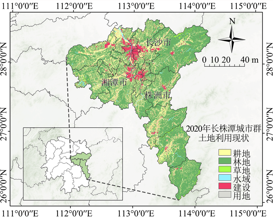
图1 长株潭城市群区位图 文本所有地图基于国家地理信息公共服务平台提供的GS(2024)0650号标准地图制作,底图边界无修改
Figure 1 Location map of Chang-Zhu-Tan urban agglomeration
| 土地利用 类型 | 地上生物量碳密度/ (t·hm−2) | 地下生物量碳密度/ (t·hm−2) | 土壤碳密度/ (t·hm−2) | 死亡有机物碳密度/ (t·hm−2) |
|---|---|---|---|---|
| 耕地 | 17.74 | 49.80 | 99.70 | 1.06 |
| 林地 | 38.21 | 78.49 | 159.22 | 1.29 |
| 草地 | 14.83 | 47.37 | 95.95 | 0.75 |
| 水域 | 22.40 | 79.00 | 0.00 | 0.00 |
| 建设用地 | 6.67 | 28.39 | 40.24 | 0.00 |
| 未利用地 | 5.10 | 24.30 | 0.00 | 0.00 |
表1 各类土地利用类型的碳密度
Table 1 Carbon density of each land use type
| 土地利用 类型 | 地上生物量碳密度/ (t·hm−2) | 地下生物量碳密度/ (t·hm−2) | 土壤碳密度/ (t·hm−2) | 死亡有机物碳密度/ (t·hm−2) |
|---|---|---|---|---|
| 耕地 | 17.74 | 49.80 | 99.70 | 1.06 |
| 林地 | 38.21 | 78.49 | 159.22 | 1.29 |
| 草地 | 14.83 | 47.37 | 95.95 | 0.75 |
| 水域 | 22.40 | 79.00 | 0.00 | 0.00 |
| 建设用地 | 6.67 | 28.39 | 40.24 | 0.00 |
| 未利用地 | 5.10 | 24.30 | 0.00 | 0.00 |

图2 长株潭城市群高程、坡度、地形起伏度和地形位指数空间分布图
Figure 2 Spatial pattern of elevation, slope, topographic relief and topographic position index in Chang-Zhu-Tan urban agglomeration
| 级别 | 高程/m | 坡度/° | 地形起伏度/m | 地形位指数 |
|---|---|---|---|---|
| 1级 | <173 | 0-3.26 | 0-41 | 0.0385-0.2910 |
| 2级 | 173-375 | 3.26-7.71 | 41-90 | 0.2910-0.5294 |
| 3级 | 375-672 | 7.71-13.19 | 90-148 | 0.5294-0.8310 |
| 4级 | 672-1119 | 13.19-20.22 | 148-224 | 0.8310-1.1606 |
| 5级 | 1119-2073 | 20.22-43.70 | 224-585 | 1.1606-1.8339 |
表2 长株潭城市群地形数据分级标准
Table 2 Classification standard of topographic data in Chang-Zhu-tan urban agglomeration
| 级别 | 高程/m | 坡度/° | 地形起伏度/m | 地形位指数 |
|---|---|---|---|---|
| 1级 | <173 | 0-3.26 | 0-41 | 0.0385-0.2910 |
| 2级 | 173-375 | 3.26-7.71 | 41-90 | 0.2910-0.5294 |
| 3级 | 375-672 | 7.71-13.19 | 90-148 | 0.5294-0.8310 |
| 4级 | 672-1119 | 13.19-20.22 | 148-224 | 0.8310-1.1606 |
| 5级 | 1119-2073 | 20.22-43.70 | 224-585 | 1.1606-1.8339 |
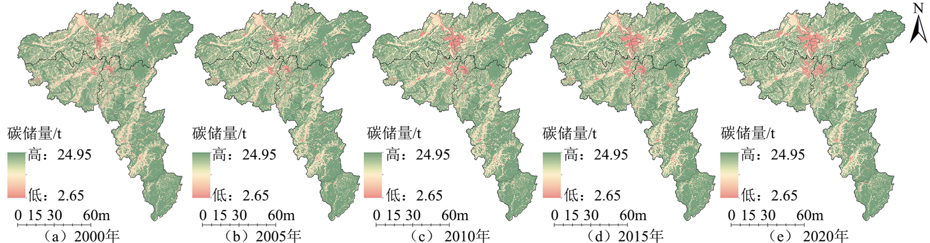
图3 2000-2020年长株潭城市群碳储量空间分布图
Figure 3 Spatial distribution map of carbon storage in Chang-Zhu-Tan urban agglomeration from 2000 to 2020
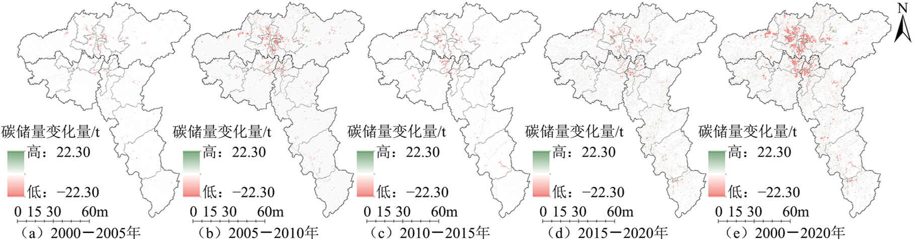
图4 长株潭城市群碳储量变化量空间分布图
Figure 4 Spatial distribution map of carbon storage change in Chang-Zhu-Tan urban agglomeration
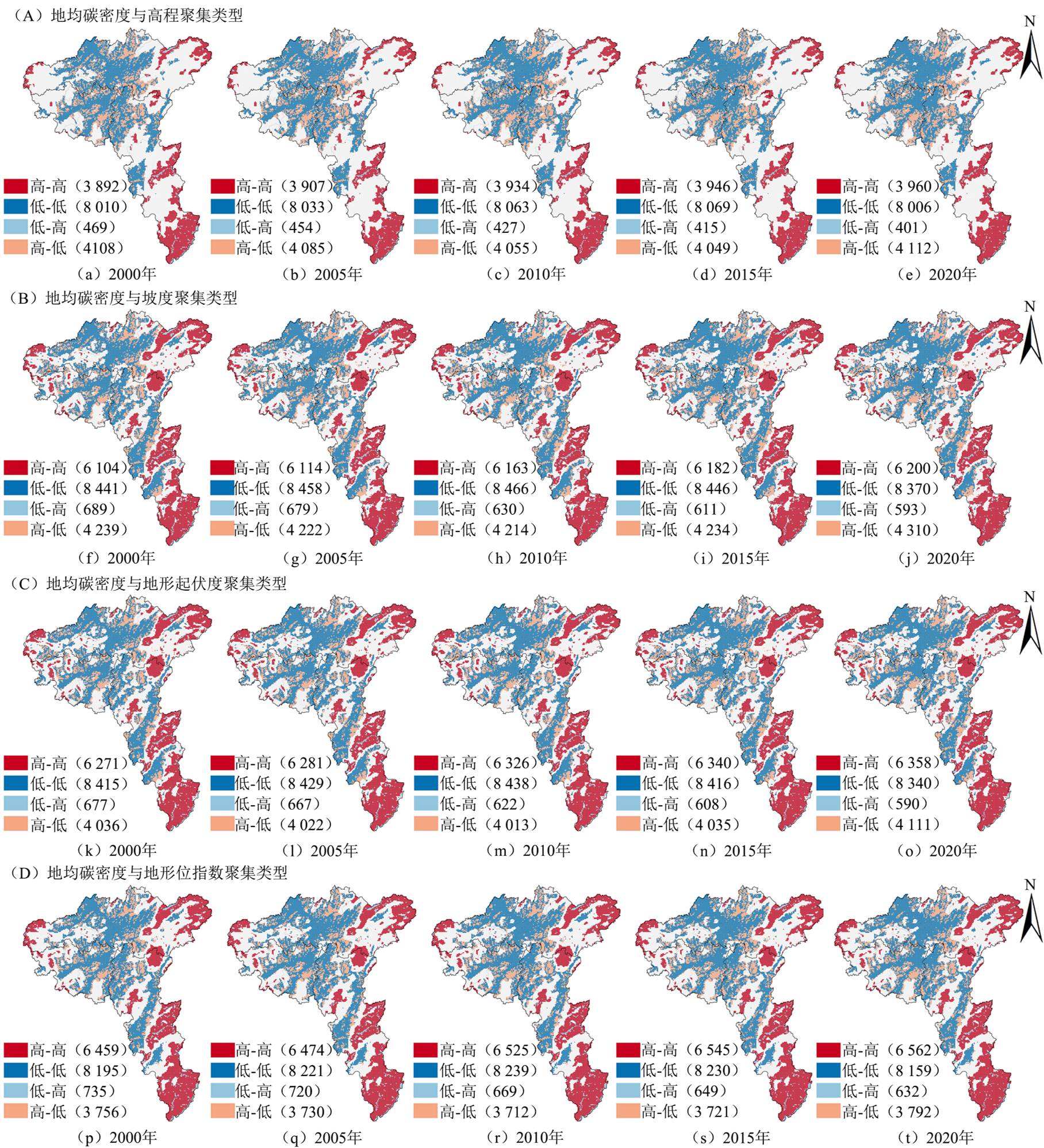
图5 2000-2020年各地形地貌指数与地均碳密度空间自相关分析
Figure 5 Spatial autocorrelation analysis of landform index and average carbon density from 2000 to 2020

图6 长株潭城市群不同地形梯度等级的地均碳密度与变化面积占比
Figure 6 The average carbon density of different topographic gradients and the proportion of changing area in Chang-Zhu-Tan urban agglomeration
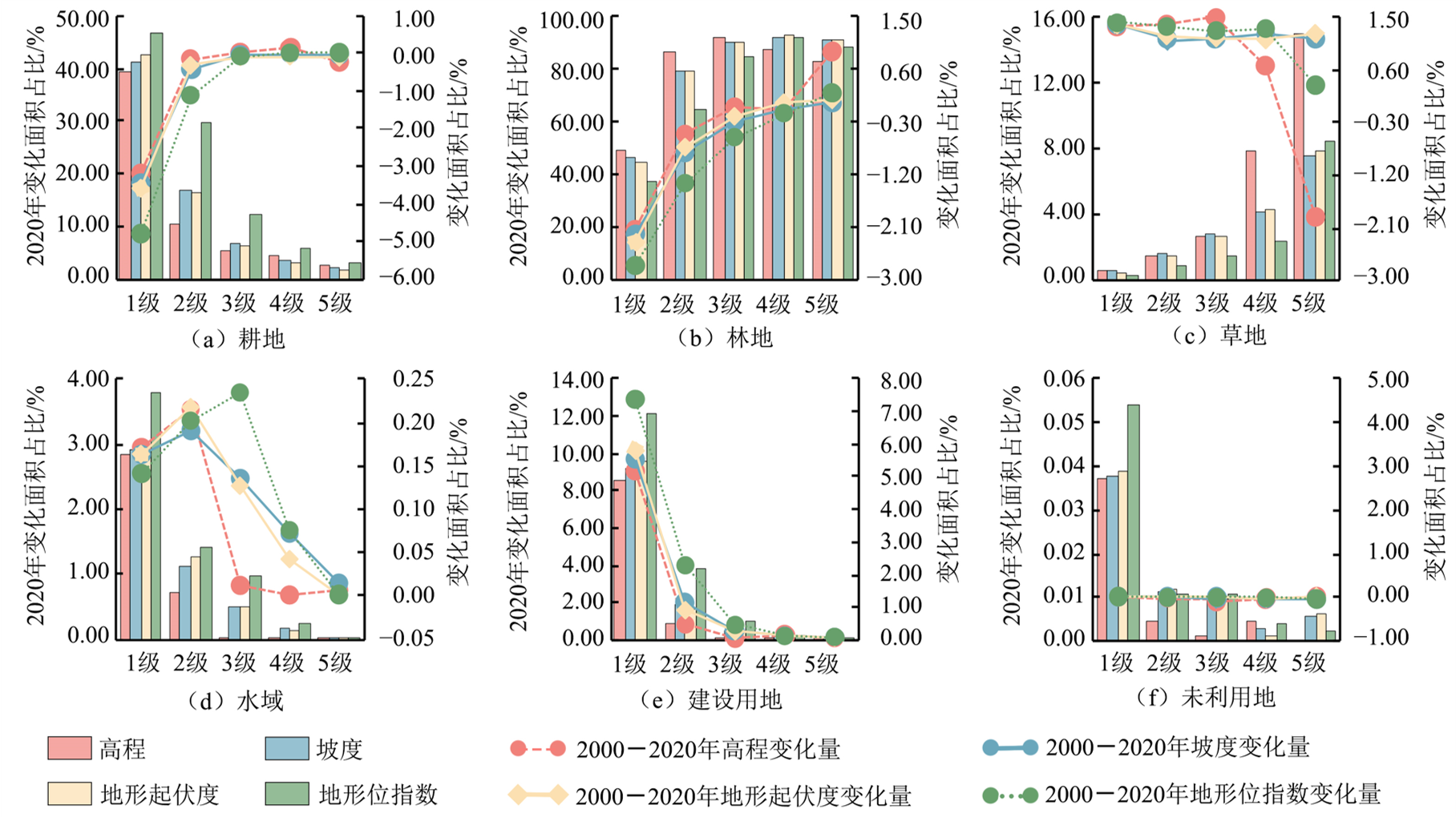
图7 长株潭城市群不同地形梯度等级的2020年各地类面积占比与2000-2020年变化面积占比
Figure 7 The area proportion of different topographic gradients in Chang-Zhu-Tan urban agglomeration in 2020 and the change area proportion from 2000 to 2020
| 年份 | 碳储量/ 106 t | 碳储量变化量/106 t | 土地利用强度 | 土地利用强度变化量 | 影响指数(PI) |
|---|---|---|---|---|---|
| 2000 | 658.26 | - | 235.06 | - | - |
| 2005 | 656.27 | −2.00 | 235.77 | 0.71 | −2.80 |
| 2010 | 650.82 | −5.45 | 237.60 | 1.82 | −2.99 |
| 2015 | 647.58 | −3.24 | 238.72 | 1.12 | −2.88 |
| 2020 | 644.20 | −3.38 | 239.93 | 1.21 | −2.79 |
表3 土地利用对碳储量服务的脆弱性评价
Table 3 Vulnerability assessment of land use to carbon storage services
| 年份 | 碳储量/ 106 t | 碳储量变化量/106 t | 土地利用强度 | 土地利用强度变化量 | 影响指数(PI) |
|---|---|---|---|---|---|
| 2000 | 658.26 | - | 235.06 | - | - |
| 2005 | 656.27 | −2.00 | 235.77 | 0.71 | −2.80 |
| 2010 | 650.82 | −5.45 | 237.60 | 1.82 | −2.99 |
| 2015 | 647.58 | −3.24 | 238.72 | 1.12 | −2.88 |
| 2020 | 644.20 | −3.38 | 239.93 | 1.21 | −2.79 |

图8 长株潭城市群不同地形梯度等级下的潜在影响指数(PI)
Figure 8 Potential Impact index (PI) under different topographic gradients in Chang-Zhu-Tan urban agglomeration
| 高程分级与坡度分级 | 1级(<173 m) | 2级(173-375 m) | 3级(375-672 m) | 4级(672-1119 m) | 5级(>1119 m) |
|---|---|---|---|---|---|
| 1级 (<3.26°) | 低碳储区(2.14) 较低碳储区(2.33) 一般碳储区(2.08) | 高碳储区 (1.02) | 高碳储区 (1.03) | 较高碳储区 (1.99) | 较高碳储区 (3.80) |
| 2级 (3.26°-7.71°) | 高碳储区 (1.02) | 较高碳储区(1.10) 高碳储区(1.12) | 较高碳储区(1.87) 高碳储区(1.13) | 较高碳储区(5.47) 高碳储区(1.07) | 较高碳储区 (10.42) |
| 3级 (7.71°-13.19°) | 高碳储区 (1.03) | 较高碳储区(1.84) 高碳储区(1.13) | 较高碳储区(3.15) 高碳储区(1.14) | 较高碳储区(9.19) 高碳储区(1.08) | 较高碳储区 (17.51) |
| 4级 (13.19°-20.22°) | 较高碳储区(1.18) 高碳储区(1.02) | 较高碳储区(2.81) 高碳储区(1.12) | 较高碳储区(4.79) 高碳储区(1.13) | 较高碳储区(13.99) 高碳储区(1.07) | 较高碳储区 (47.18) |
| 5级 (>20.22°) | 较高碳储区 (1.92) | 较高碳储区(4.97) 高碳储区(1.08) | 较高碳储区(8.48) 高碳储区(1.09) | 较高碳储区(24.77) 高碳储区(1.03) | 较高碳储区 (47.18) |
表4 长株潭城市群高程与坡度的共同优势碳储区分布
Table 4 Distribution of common advantageous carbon storage areas in elevation and slope of Chang-Zhu-Tan urban agglomeration
| 高程分级与坡度分级 | 1级(<173 m) | 2级(173-375 m) | 3级(375-672 m) | 4级(672-1119 m) | 5级(>1119 m) |
|---|---|---|---|---|---|
| 1级 (<3.26°) | 低碳储区(2.14) 较低碳储区(2.33) 一般碳储区(2.08) | 高碳储区 (1.02) | 高碳储区 (1.03) | 较高碳储区 (1.99) | 较高碳储区 (3.80) |
| 2级 (3.26°-7.71°) | 高碳储区 (1.02) | 较高碳储区(1.10) 高碳储区(1.12) | 较高碳储区(1.87) 高碳储区(1.13) | 较高碳储区(5.47) 高碳储区(1.07) | 较高碳储区 (10.42) |
| 3级 (7.71°-13.19°) | 高碳储区 (1.03) | 较高碳储区(1.84) 高碳储区(1.13) | 较高碳储区(3.15) 高碳储区(1.14) | 较高碳储区(9.19) 高碳储区(1.08) | 较高碳储区 (17.51) |
| 4级 (13.19°-20.22°) | 较高碳储区(1.18) 高碳储区(1.02) | 较高碳储区(2.81) 高碳储区(1.12) | 较高碳储区(4.79) 高碳储区(1.13) | 较高碳储区(13.99) 高碳储区(1.07) | 较高碳储区 (47.18) |
| 5级 (>20.22°) | 较高碳储区 (1.92) | 较高碳储区(4.97) 高碳储区(1.08) | 较高碳储区(8.48) 高碳储区(1.09) | 较高碳储区(24.77) 高碳储区(1.03) | 较高碳储区 (47.18) |
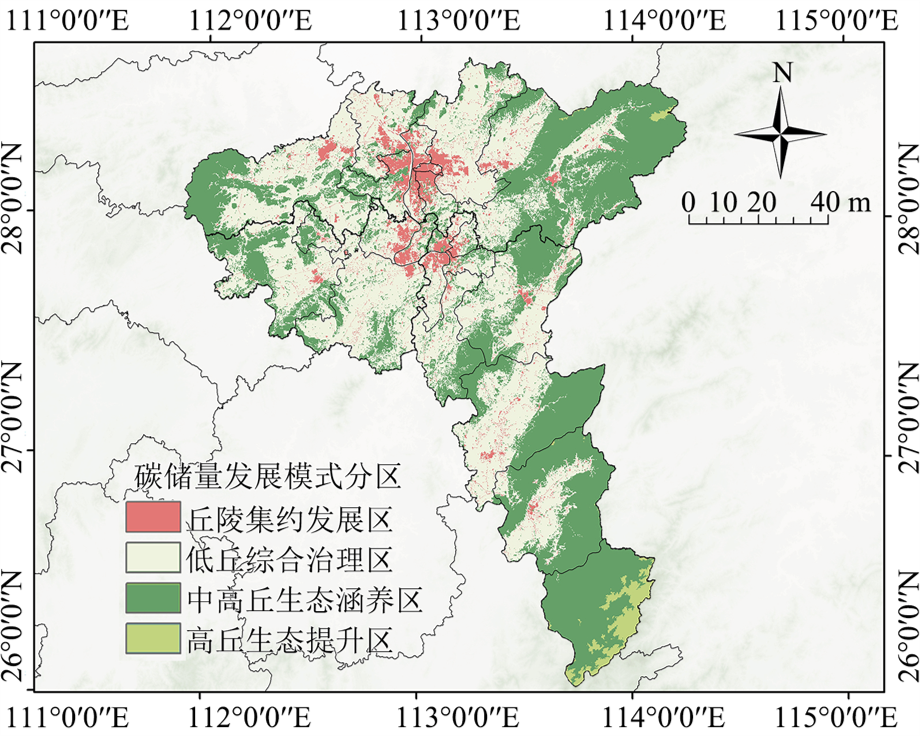
图9 长株潭城市群碳储量分区结果
Figure 9 Zoning results of carbon storage in Chang-Zhu-Tan urban agglomeration
| [1] |
FANG J Y, CHEN A P, PENG C H, et al., 2001. Changes in forest biomass carbon storage in China between 1949 and 1998[J]. Science, 292(5525): 2320-2322.
DOI PMID |
| [2] | GONG J, LIU D Q, ZHANG J X, et al., 2019. Tradeoffs/synergies of multiple ecosystem services based on land use simulation in a mountain-basin area, western China[J]. Ecological Indicators, 99: 283-293. |
| [3] | HE Y L, MA J M, ZHANG C S, et al., 2023. Spatio-temporal evolution and prediction of carbon storage in Guilin based on FLUS and InVEST models[J]. Remote Sensing, 15(5): 1445. |
| [4] | METZGER M J, ROUNSEVELL M D A, ACOSTA-MICHLIK L, et al., 2006. The vulnerability of ecosystem services to land use change[J]. Agriculture Ecosystems & Environment, 114(1): 69-85. |
| [5] | MYEONG S, NOWAK D J, DUGGIN M J, 2006. A temporal analysis of urban forest carbon storage using remote sensing[J]. Remote Sensing of Environment, 101(2): 277-282. |
| [6] | NIE X, LU B, CHEN Z P, et al., 2020. Increase or decrease? Integrating the CLUMondo and InVEST models to assess the impact of the implementation of the Major Function Oriented Zone planning on carbon storage[J]. Ecological Indicators, 118: 106708. |
| [7] | PENG Y L, CHENG W Y, XU X X, et al., 2024. Analysis and prediction of the spatiotemporal characteristics of land-use ecological risk and carbon storage in Wuhan metropolitan area[J]. Ecological Indicators, 158: 111432. |
| [8] | REED W P, KAYE M W, 2020. Bedrock type drives forest carbon storage and uptake across the mid-Atlantic Appalachian Ridge and Valley, U.S.A.[J]. Forest Ecology and Management, 460: 117881. |
| [9] |
SCHRÖTER D, CRAMER W, LEEMANS R, et al., 2005. Ecosystem service supply and vulnerability to global change in Europe[J]. Science, 310(5752): 1333-1337.
DOI PMID |
| [10] | SUN B Q, DU J Q, CHONG F F, et al., 2023. Spatio-temporal variation and prediction of carbon storage in terrestrial ecosystems in the Yellow River Basin[J]. Remote Sensing, 15(15): 3866. |
| [11] | SUN W L, LIU X H, 2020. Review on carbon storage estimation of forest ecosystem and applications in China[J]. Forest Ecosystems, 7(1): 1-14. |
| [12] |
WANG G, GUAN D S, XIAO L, et al., 2019. Forest biomass-carbon variation affected by the climatic and topographic factors in Pearl River Delta, South China[J]. Journal of Environmental Management, 232: 781-788.
DOI PMID |
| [13] | WANG Y F, LI M Y, JIN G Z, 2024. Exploring the optimization of spatial patterns for carbon sequestration services based on multi-scenario land use/cover changes in the Changchun-Jilin-Tumen region, China[J]. Journal of Cleaner Production, 438: 140788. |
| [14] | WANG Z Y, LI X, MAO Y T, et al., 2022. Dynamic simulation of land use change and assessment of carbon storage based on climate change scenarios at the city level: A case study of Bortala, China[J]. Ecological Indicators, 134: 108499. |
| [15] | WOLCH J R, BYRNE J, NEWELL J P, 2014. Urban green space, public health, and environmental justice: The challenge of making cities ‘just green enough’[J]. Landscape and Urban Planning, 125: 234-244. |
| [16] | WU F, WANG Z Y, 2023. Assessing the impact of urban land expansion on ecosystem carbon storage: A case study of the Changzhutan metropolitan area, China[J]. Ecological Indicators, 154: 110688. |
| [17] | WU Q, WANG L, WANG T Y, et al., 2024. Spatial-temporal evolution analysis of multi-scenario land use and carbon storage based on PLUS-InVEST model: A case study in Dalian, China[J]. Ecological Indicators, 166: 112448. |
| [18] | WU S N, LI J Q, ZHOU W M, et al., 2018. A statistical analysis of spatiotemporal variations and determinant factors of forest carbon storage under China’s Natural Forest Protection Program[J]. Journal of Forestry Research, 29(2): 415-424. |
| [19] |
YANG Y H, SHI Y, SUN W J, et al., 2022. Terrestrial carbon sinks in China and around the world and their contribution to carbon neutrality[J]. Science China-life Sciences, 65(5): 861-895.
DOI PMID |
| [20] | YUAN H, ZHANG Z H, FENG D D, et al., 2024. Assessment of the impact of land use/land cover change on carbon storage in Chengdu, China, in the context of carbon peaking and carbon neutrality, 2000-2030[J]. Environment Development and Sustainability, 16(2): 1-24. |
| [21] | ZHANG H Y, LI X, LUO Y P, et al., 2024. Spatial heterogeneity and driving mechanisms of carbon storage in the urban agglomeration within complex terrain: Multi-scale analyses under localized SSP-RCP narratives[J]. Sustainable Cities and Society, 109: 105520. |
| [22] | ZHANG L, ZHOU G S, JI Y H, et al., 2016. Spatiotemporal dynamic simulation of grassland carbon storage in China[J]. Science China Earth Sciences, 59(10): 1946-1958. |
| [23] | ZHU J J, HU X J, XU W Z, et al., 2023. Regional carbon stock response to land use structure change and multi-scenario prediction: A case study of Hunan province, China[J]. Sustainability, 15(16): 12178. |
| [24] | ZHU M, FENG Q, QIN Y Y, et al., 2019. The role of topography in shaping the spatial patterns of soil organic carbon[J]. Catena, 176: 296-305. |
| [25] | 巴曙松, 吴大义, 2010. 能源消费、二氧化碳排放与经济增长——基于二氧化碳减排成本视角的实证分析[J]. 经济与管理研究, 31(6): 5-11, 101. |
| BA S S, WU D Y, 2010. Empirical evidence of the relation among energy consumption, carbon dioxide emissions and economic growth based on the abatement costs[J]. Research on Economics and Management, 31(6): 5-11, 101. | |
| [26] | 陈一溥, 2022. 空间扩张背景下长株潭城市群热环境变化与空间格局优化研究[D]. 长沙: 中南大学. |
| CHEN Y B, 2022. Study on thermal environment changes and spatial pattern optimization of Chang-Zhu-Tan City Cluster in the context of spatial expansion[D]. Changsha: Central South University. | |
| [27] | 李代超, 卢嘉奇, 谢晓苇, 等, 2022. 碳中和视角下基于主体功能区分类约束的国土空间分区优化模拟——以福建省为例[J]. 生态学报, 42(24): 10111-10126. |
| LI D C, LU J Q, XIE X W, et al., 2022. Optimization simulation of land space zoning based on the classification constraints of main functional zones from the perspective of carbon neutrality: A case study of Fujian Province[J]. Acta Ecologica Sinica, 42(24): 10111-10126. | |
| [28] | 李倩, 王成军, 冯涛, 等, 2024. 基于SD-PLUS耦合模型的陕西省土地利用变化及碳储量多情景预测[J]. 水土保持学报, 38(3): 195-206, 215. |
| LI Q, WANG C J, FENG T, et al., 2024. Multi-scenario prediction of land use change and carbon storage in Shaanxi Province based on the SD-PLUS coupled model[J]. Journal of Soil and Water Conservation, 38(3): 195-206, 215. | |
| [29] | 刘金龙, 马程, 王阳, 等, 2013. 基于径向基函数网络的京津冀地区生态系统服务脆弱性评估[J]. 北京大学学报(自然科学版), 49(6): 1040-1046. |
| LIU J L, MA C, WANG Y, et al., 2013. Assessing the vulnerability of ecosystem services of Beijing-Tianjin-Hebei Area based on radial basis function network[J]. Acta Scientiarum Naturalium Universitatis Pekinensis, 49(6): 1040-1046. | |
| [30] | 马勇洁, 仲俊涛, 米文宝, 等, 2023. 基于青海湖流域土地利用多情景模拟预测的碳储量评估及其脆弱性分析[J]. 干旱区资源与环境, 37(10): 46-55. |
| MA Y J, ZHONG J T, MI W B, et al., 2023. Assessment and vulnerability analysis on carbon storage based on multi-scenarios simulation and prediction of land use in Qinghai Lake basin[J]. Journal of Arid Land Resources and Environment, 37(10): 46-55. | |
| [31] | 糜毅, 李涛, 吴博, 等, 2023. 基于优化模拟的长株潭3+5城市群碳储量时空演变与预测[J]. 环境工程技术学报, 13(5): 1740-1751. |
| MI Y, LI T, WU B, et al., 2023. Spatio-temporal evolution and prediction of carbon storage in Chang-Zhu-Tan 3+5 urban agglomeration based on optimization simulation[J]. Journal of Environmental Engineering Technology, 13(5): 1740-1751. | |
| [32] | 唐尧, 祝炜平, 张慧, 等, 2015. InVEST模型原理及其应用研究进展[J]. 生态科学, 34(3): 204-208. |
| TANG Y, ZHU W P, ZHANG H, et al., 2015. A review on principle and application of the InVEST model[J]. Ecological Science, 34(3): 204-208. | |
| [33] | 万海峰, 蒙友波, 陈洋, 等, 2024. 黔中城市群碳储量对土地利用/覆被变化的响应及脆弱性[J]. 水土保持通报, 44(1): 443-452. |
| WAN H F, MENG Y B, CHEN Y, et al., 2024. Response of carbon storage to land use/cover changes and vulnerability for Central Guizhou Urban Agglomeration[J]. Bulletin of Soil and Water Conservation, 44(1): 443-452. | |
| [34] | 王芳, 周兴, 2012. 人口结构、城镇化与碳排放——基于跨国面板数据的实证研究[J]. 中国人口科学, 26(2): 47-56, 111. |
| WANG F, ZHOU X, 2012. Population structure, urbanization and CO2 emission: An empirical study base on cross-country panel data[J]. Chinese Journal of Population Science, 26(2): 47-56, 111. | |
| [35] | 王怀毅, 李忠魁, 2024. 基于LUCC的渭河流域生态系统碳储量动态变化及脆弱性分析[J]. 水土保持研究, 31(6): 252-260, 270. |
| WANG H Y, LI Z K, 2024. Dynamic changes and vulnerability analysis of carbon storage in the Weihe River basin ecosystem based on LUCC[J]. Research of Soil and Water Conservation, 31(6): 252-260, 270. | |
| [36] | 吴双, 马帅, 王慧勇, 等, 2023. 不同海拔梯度南方丘陵山地带生态系统服务价值的时空演变[J]. 生态学杂志, 42(4): 966-974. |
|
WU S, MA S, WANG H Y, et al., 2023. Spatiotemporal variations of ecosystem service value in the hill and mountain belt of southern China across different altitude gradients[J]. Chinese Journal of Ecology, 42(4): 966-974.
DOI |
|
| [37] |
向书江, 张骞, 王丹, 等, 2022. 近20年重庆市主城区碳储量对土地利用/覆被变化的响应及脆弱性分析[J]. 自然资源学报, 37(5): 1198-1213.
DOI |
| XIANG S J, ZHANG Q, WANG D, et al., 2022. Response and vulnerability analysis of carbon storage to LUCC in the main urban area of Chongqing during 2000-2020[J]. Journal of Natural Resources, 37(5): 1198-1213. | |
| [38] | 徐彩仙, 巩杰, 李焱, 等, 2020. 基于地形梯度的甘肃白龙江流域典型生态系统服务分布特征[J]. 生态学报, 40(13): 4291-4301. |
| XU C X, GONG J, LI Y, et al., 2020. Spatial distribution characteristics of typical ecosystem services based on terrain gradients of Bailongjiang Watershed in Gansu[J]. Acta Ecologica Sinica, 40(13): 4291-4301. | |
| [39] | 徐丽, 何念鹏, 于贵瑞, 2019. 2010s中国陆地生态系统碳密度数据集[J]. 中国科学数据(中英文网络版), 4(1): 90-96. |
| XU L, HE N P, YU G R, 2019. A dataset of carbon density in Chinese terrestrial ecosystems (2010s)[J]. China Scientific Data, 4(1): 90-96. | |
| [40] | 杨子豪, 陈德超, 郎峥, 等, 2024. 土地利用变化对生态系统碳储量的影响研究: 以苏州市为例[J]. 环境科学与技术, 47(2): 206-214. |
| YANG Z H, CHEN D C, LANG Z, et al., 2024. Study on the impact of land use change on ecosystem carbon storage: Taking Suzhou city as an example[J]. Environmental Science & Technology, 47(2): 206-214. | |
| [41] | 喻红, 曾辉, 江子瀛, 2001. 快速城市化地区景观组分在地形梯度上的分布特征研究[J]. 地理科学, 21(1): 64-69. |
|
YU H, ZENG H, JIANG Z Y, 2001. Study on distribution characteristics of landscape elements along the terrain gradient[J]. Scientia Geographica Sinica, 21(1): 64-69.
DOI |
|
| [42] | 张斌, 夏秋月, 2023. 武汉城市圈碳储量的地形梯度效应及脆弱性[J]. 水土保持研究, 30(5): 443-452. |
| ZHANG B, XIA Q Y, 2023. Topographic gradient effect and vulnerability analysis of carbon storage in Wuhan urban circle[J]. Research of Soil and Water Conservation, 30(5): 443-452. | |
| [43] | 张爽, 高启晨, 张戎, 等, 2024. 基于PLUS-InVEST模型碳储量时空演变及驱动因素分析——以纳帕海流域为例[J]. 中国环境科学, 44(9): 5192-5201. |
| ZHANG S, GAO Q C, ZHANG R, et al., 2024. Evaluating the changes and driving factors of carbon storage using the PLUS-InVEST Model: A case study of Napa Sea Basin[J]. China Environmental Science, 44(9): 5192-5201. | |
| [44] | 张艺, 2023. 土地利用变化下的长株潭都市圈碳储量时空演变及模拟研究[D]. 长沙: 中南林业科技大学. |
| ZHANG Y, 2023. Spatio-temporal evolution and simulation of carbon storage based on land use change in Chang-Zhu-Tan Metropolitan circle[D]. Changsha: Central South University of Forestry and Technology. | |
| [45] | 张哲, 时振钦, 朱文博, 等, 2024. 基于InVEST模型的伏牛山地区生态系统碳储量时空变化模拟[J]. 环境科学, 45(4): 2332-2341. |
| ZHANG Z, SHI Z Q, ZHU W B, et al., 2024. Simulation of temporal and spatial changes in ecosystem carbon storage in Funiu mountains based on InVEST model[J]. Environmental Science, 45(4): 2332-2341. | |
| [46] | 赵艳霞, 武爱彬, 刘欣, 等, 2014. 浅山丘陵区土地利用地形梯度特征与生态服务价值响应[J]. 水土保持研究, 21(3): 141-145. |
| ZHAO Y X, WU A B, LIU X, et al., 2024. Terrain gradient features and response of ecological services value in shallow hilly region[J]. Research of Soil and Water Conservation, 21(3): 141-145. | |
| [47] | 周建伟, 罗君, 2023. 安宁河流域土地利用地形梯度分异及其转型驱动因素[J]. 西南农业学报, 36(6): 1318-1327. |
| ZHOU J W, LUO J, 2023. Terrain gradient differentiation of land use and driving factors of its change in Anning River Basin[J]. Southwest China Journal of Agricultural Sciences, 36(6): 1318-1327. | |
| [48] |
朱文博, 张静静, 崔耀平, 等, 2019. 基于土地利用变化情景的生态系统碳储量评估——以太行山淇河流域为例[J]. 地理学报, 74(3): 446-459.
DOI |
|
ZHU W B, ZHANG J J, CUI Y P, et al., 2019. Assessment of territorial ecosystem carbon storage based on land use change scenario: A case study in Qihe River Basin[J]. Acta Geographica Sinica, 74(3): 446-459.
DOI |
| [1] | 吴雨桐, 於冉, 余祺琪, 王成, 张紫涵. 皖江流域生境质量评价及多情景优化研究[J]. 生态环境学报, 2025, 34(6): 961-973. |
| [2] | 王天雯, 罗明良, 白雷超. 嘉陵江流域生态系统服务动态变化及权衡协同分析[J]. 生态环境学报, 2025, 34(6): 888-901. |
| [3] | 张洪波, 尹班, 李春勇, 崔松云, 和艳, 李小红, 邓丽仙. 近40年红河流域(中国部分)水源涵养功能动态演变特征及驱动因素[J]. 生态环境学报, 2025, 34(4): 556-569. |
| [4] | 李曼, 吴东丽, 何昊, 余慧婕, 赵琳, 刘聪, 胡正华, 李琪. 1990-2020年黄河流域碳储量时空演变及驱动因素研究[J]. 生态环境学报, 2025, 34(3): 333-344. |
| [5] | 张继, 杨世琦, 赵磊, 冯介玲, 陈艳英. 基于InVEST模型的重庆市“一带三屏”生境质量时空演变特征分析[J]. 生态环境学报, 2025, 34(2): 167-180. |
| [6] | 马月伟, 陈玉美, 张盛蓝, 桂雅丽, 陈艳梅. 夹金山脉大熊猫栖息地生境质量与人类活动强度耦合协调研究[J]. 生态环境学报, 2025, 34(2): 197-208. |
| [7] | 唐建亭, 袁杰, 陈宗颜, 李晓燕, 孙子婷. 祁连山南坡土地利用变化及碳储量研究[J]. 生态环境学报, 2024, 33(9): 1353-1361. |
| [8] | 张雯, 郑天, 刘永超, 钟捷, 苏杰, 李加林. 基于电路理论的浙江省生态保护修复关键区域识别[J]. 生态环境学报, 2024, 33(9): 1482-1494. |
| [9] | 王雯, 侯青青, 裴婷婷. 甘肃河东地区坡度对生态系统服务的影响及其阈值效应[J]. 生态环境学报, 2024, 33(7): 1117-1129. |
| [10] | 杨非凡, 何浩. 基于“EVI-ESV”伊犁河谷生态环境评估及生态分区构建[J]. 生态环境学报, 2024, 33(4): 655-664. |
| [11] | 罗光浴, 王志远. 洞庭湖生态经济区国土空间格局演变的碳储量效应及驱动因素研究[J]. 生态环境学报, 2024, 33(11): 1672-1685. |
| [12] | 高文明, 宋芊, 张皓翔, 王士如. 三江源区生态脆弱性时空演变及驱动因素分析[J]. 生态环境学报, 2024, 33(10): 1648-1660. |
| [13] | 宋灯辉, 付迪, 黎建强, 付钇珊, 邢学霞, 田原. 云南松林计划烧除地表碳损失量及碳排放量估算[J]. 生态环境学报, 2023, 32(8): 1376-1383. |
| [14] | 徐梓津, 张雪松, 陈明曼. 山地岩溶区生态系统服务时空演变特征分析——以贵州省为例[J]. 生态环境学报, 2023, 32(7): 1196-1206. |
| [15] | 张平江, 党国锋. 基于MCR模型与蚁群算法的洮河流域生态安全格局构建[J]. 生态环境学报, 2023, 32(3): 481-491. |
| 阅读次数 | ||||||
|
全文 |
|
|||||
|
摘要 |
|
|||||