生态环境学报 ›› 2020, Vol. 29 ›› Issue (2): 293-302.DOI: 10.16258/j.cnki.1674-5906.2020.02.010
雷金睿( ), 陈宗铸*(), 陈毅青, 陈小花, 李苑菱, 吴庭天
收稿日期:2019-11-15
出版日期:2020-02-18
发布日期:2020-04-01
通讯作者:
* 陈宗铸(1977年生),男,副研究员,博士,研究方向为林业3S技术。E-mail: chenzongzhu@foxmail.com作者简介:雷金睿(1988年生),男,助理研究员,硕士,研究方向为湿地植物与景观演变。E-mail: raykingre@163.com
基金资助:
LEI Jinrui(), CHEN Zongzhu*(), CHEN Yiqing, CHEN Xiaohua, LI Yuanling, WU Tingtian
Received:2019-11-15
Online:2020-02-18
Published:2020-04-01
摘要:
海南岛是中国重要的生态功能区,在国家战略背景下,湿地景观呈现多样化的利用方式。科学评估海南岛湿地景观生态安全格局,对湿地资源进行有效保护是实现可持续发展的重要保障。以海南岛为研究区,基于PSR模型构建海南岛湿地景观生态安全评价体系,采用层次分析法确定指标权重,利用1990、2000、2010、2018年4期Landsat遥感影像的湿地解译数据,以及人口、经济等指标为数据源,在遥感和GIS技术的支持下分析了1990—2018年海南岛湿地景观生态安全状况及其空间分布特征。结果表明,(1)1990—2018年间,海南岛湿地景观总面积呈增长趋势,总面积由1990年的944.36 km2增加到2018年的1337.57 km2。其中,人工湿地呈明显增长趋势,自然湿地则呈减少趋势;各市县湿地面积增长最多的是文昌、东方、海口和儋州等。(2)海南岛湿地景观生态安全指数(LESI)在总体上呈下降趋势,安全等级由临界安全演变为较危险状态,且在2010—2018年间LESI变化较大;至2018年,总体上呈现出“海南岛北部和南部市县的LESI低,中部山区市县的LESI高”的空间分布格局。(3)采用自然断点法将1990—2018年海南岛湿地LESI变化幅度分为4个级别,LESI值降幅最大的为海口、三亚、文昌、澄迈4个经济发达市县;保亭、白沙、乐东和琼中4个中部市县的LESI值则略微提升。提出严格实施湿地资源规划分区分级管控和湿地生态修复工程,维护和强化湿地生态空间的连续性和完整性。
中图分类号:
雷金睿, 陈宗铸, 陈毅青, 陈小花, 李苑菱, 吴庭天. 1990—2018年海南岛湿地景观生态安全格局演变[J]. 生态环境学报, 2020, 29(2): 293-302.
LEI Jinrui, CHEN Zongzhu, CHEN Yiqing, CHEN Xiaohua, LI Yuanling, WU Tingtian. Dynamic Analysis of Wetland Landscape Ecological Security Pattern of Hainan Island in 1990‒2018[J]. Ecology and Environment, 2020, 29(2): 293-302.
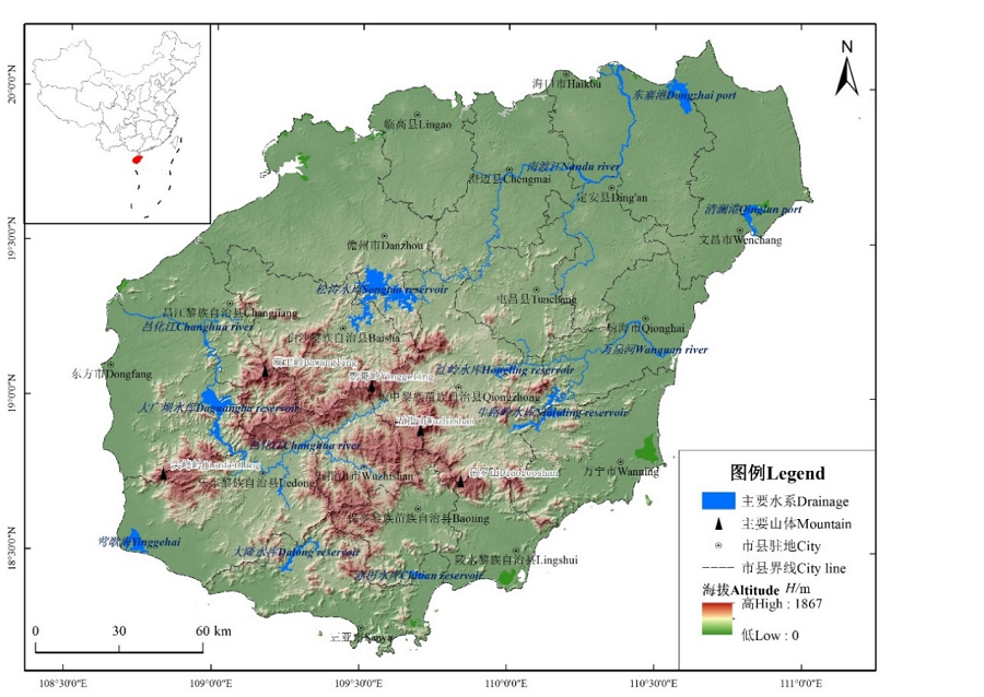
图1 研究区位置
Fig. 1 Location of the study area
| 目标层 Object layer | 准则层 Criterion layer | 指标层 Indicators layer | 正向/负向Positive/negative | 数据来源 Data sources | 权重值 Weight value |
|---|---|---|---|---|---|
| 景观生态 安全 (A) Landscape ecological security (A) | 景观状态 (B1) Landscape state 0.5396 | 景观破碎度 Landscape fragment (C1) | 负向 Negative | 遥感数据 Remote sensing data | 0.1854 |
| 景观多样性 Landscape diversity (C2) | 负向 Negative | 遥感数据 Remote sensing data | 0.0471 | ||
| 景观连接度 Landscape connectivity (C3) | 正向 Positive | 遥感数据 Remote sensing data | 0.0837 | ||
| 分维数 Landscape fractal dimension (C4) | 负向 Negative | 遥感数据 Remote sensing data | 0.0837 | ||
| 自然与人工湿地面积比 Area ratio of natural wetland and constructed wetland (C5) | 正向 Positive | 遥感数据 Remote sensing data | 0.1396 | ||
| 景观压力 (B2) Landscape pressure 0.2970 | 城市化水平 Urbanization level (C6) | 负向 Negative | 统计数据 Statistic data | 0.0486 | |
| 人口密度 Population density (C7) | 负向 Negative | 统计数据 Statistic data | 0.0882 | ||
| 人均GDP GDP per head (C8) | 负向 Negative | 统计数据 Statistic data | 0.1603 | ||
| 景观响应 (B3) Landscape response 0.1634 | 自然保护地面积占比 Area ratio of nature reserve (C9) | 正向 Positive | 行业数据 Industry data | 0.0817 | |
| 湿地保护资金投入 Investment in wetland protection (C10) | 正向 Positive | 行业数据 Industry data | 0.0817 |
表1 海南岛湿地景观生态安全评价指标体系及权重
Table 1 Evaluation indexes of wetlands landscape ecological security and their weights in Hainan Island
| 目标层 Object layer | 准则层 Criterion layer | 指标层 Indicators layer | 正向/负向Positive/negative | 数据来源 Data sources | 权重值 Weight value |
|---|---|---|---|---|---|
| 景观生态 安全 (A) Landscape ecological security (A) | 景观状态 (B1) Landscape state 0.5396 | 景观破碎度 Landscape fragment (C1) | 负向 Negative | 遥感数据 Remote sensing data | 0.1854 |
| 景观多样性 Landscape diversity (C2) | 负向 Negative | 遥感数据 Remote sensing data | 0.0471 | ||
| 景观连接度 Landscape connectivity (C3) | 正向 Positive | 遥感数据 Remote sensing data | 0.0837 | ||
| 分维数 Landscape fractal dimension (C4) | 负向 Negative | 遥感数据 Remote sensing data | 0.0837 | ||
| 自然与人工湿地面积比 Area ratio of natural wetland and constructed wetland (C5) | 正向 Positive | 遥感数据 Remote sensing data | 0.1396 | ||
| 景观压力 (B2) Landscape pressure 0.2970 | 城市化水平 Urbanization level (C6) | 负向 Negative | 统计数据 Statistic data | 0.0486 | |
| 人口密度 Population density (C7) | 负向 Negative | 统计数据 Statistic data | 0.0882 | ||
| 人均GDP GDP per head (C8) | 负向 Negative | 统计数据 Statistic data | 0.1603 | ||
| 景观响应 (B3) Landscape response 0.1634 | 自然保护地面积占比 Area ratio of nature reserve (C9) | 正向 Positive | 行业数据 Industry data | 0.0817 | |
| 湿地保护资金投入 Investment in wetland protection (C10) | 正向 Positive | 行业数据 Industry data | 0.0817 |
| 安全等级 Security level | 景观生态安全指数LESI Landscape ecological security index | 安全状态 Security state |
|---|---|---|
| I | [0, 0.4) | 危险 (差) Dangerous |
| II | [0.4, 0.5) | 较危险 (较差) More dangerous |
| III | [0.5, 0.6) | 临界安全 (一般) Critical safety |
| IV | [0.6, 0.7) | 较安全 (良好) Safer |
| V | [0.7, 1.0] | 安全 (好) Safe |
表2 景观生态安全等级划分标准
Table 2 Classification standard of landscape ecological security
| 安全等级 Security level | 景观生态安全指数LESI Landscape ecological security index | 安全状态 Security state |
|---|---|---|
| I | [0, 0.4) | 危险 (差) Dangerous |
| II | [0.4, 0.5) | 较危险 (较差) More dangerous |
| III | [0.5, 0.6) | 临界安全 (一般) Critical safety |
| IV | [0.6, 0.7) | 较安全 (良好) Safer |
| V | [0.7, 1.0] | 安全 (好) Safe |
| 类型 Type | 人工湿地 Constructed wetland/km2 | 自然湿地 Natural wetland/km2 | 湿地总面积 Total area of wetlands/km2 | |||||||||||
|---|---|---|---|---|---|---|---|---|---|---|---|---|---|---|
| 年份 Year | 1990 | 2000 | 2010 | 2018 | 1990 | 2000 | 2010 | 2018 | 1990 | 2000 | 2010 | 2018 | ||
| 白沙 Baisha | 19.81 | 16.40 | 24.22 | 25.37 | 5.31 | 5.87 | 5.35 | 6.05 | 25.13 | 22.27 | 29.56 | 31.42 | ||
| 保亭 Baoting | 3.48 | 5.38 | 6.73 | 8.99 | 1.79 | 1.99 | 1.94 | 2.54 | 5.26 | 7.37 | 8.67 | 11.54 | ||
| 昌江 Changjiang | 13.15 | 12.50 | 17.16 | 20.47 | 17.46 | 13.37 | 17.86 | 15.43 | 30.62 | 25.87 | 35.02 | 35.89 | ||
| 澄迈 Chengmai | 14.73 | 19.67 | 19.51 | 21.44 | 31.41 | 30.93 | 35.96 | 30.03 | 46.14 | 50.60 | 55.48 | 51.47 | ||
| 儋州 Danzhou | 109.65 | 104.18 | 142.03 | 144.90 | 68.78 | 67.74 | 57.50 | 62.51 | 178.43 | 171.93 | 199.53 | 207.41 | ||
| 定安 Dingan | 14.96 | 20.08 | 13.41 | 18.60 | 7.70 | 8.26 | 8.24 | 6.58 | 22.66 | 28.34 | 21.65 | 25.18 | ||
| 东方 Dongfang | 26.43 | 102.23 | 94.96 | 114.16 | 33.25 | 17.30 | 22.41 | 18.16 | 59.68 | 119.53 | 117.36 | 132.33 | ||
| 海口 Haikou | 33.06 | 47.46 | 59.98 | 64.86 | 87.03 | 92.10 | 89.54 | 84.81 | 120.09 | 139.56 | 149.53 | 149.67 | ||
| 乐东 Ledong | 62.23 | 67.38 | 68.62 | 72.92 | 24.40 | 14.88 | 16.58 | 28.08 | 86.62 | 82.26 | 85.20 | 101.00 | ||
| 临高 Lingao | 16.01 | 16.76 | 15.08 | 15.94 | 13.61 | 12.72 | 9.06 | 9.63 | 29.62 | 29.48 | 24.15 | 25.57 | ||
| 陵水 Lingshui | 11.56 | 15.93 | 18.77 | 22.28 | 36.67 | 36.31 | 35.22 | 37.25 | 48.23 | 52.24 | 54.00 | 59.53 | ||
| 琼海 Qionghai | 20.30 | 33.37 | 28.41 | 43.26 | 21.17 | 27.55 | 22.35 | 24.89 | 41.47 | 60.93 | 50.75 | 68.15 | ||
| 琼中 Qiongzhong | 4.01 | 9.91 | 4.63 | 21.87 | 7.81 | 7.16 | 6.23 | 6.86 | 11.81 | 17.08 | 10.86 | 28.73 | ||
| 三亚 Sanya | 14.75 | 28.10 | 39.39 | 47.16 | 34.44 | 25.11 | 18.78 | 24.88 | 49.19 | 53.20 | 58.18 | 72.04 | ||
| 屯昌 Tunchang | 8.21 | 11.16 | 9.47 | 13.06 | 1.76 | 2.21 | 1.13 | 2.33 | 9.97 | 13.37 | 10.60 | 15.39 | ||
| 万宁 Wanning | 30.36 | 42.78 | 42.77 | 60.70 | 57.94 | 58.04 | 61.81 | 53.31 | 88.30 | 100.81 | 104.57 | 114.02 | ||
| 文昌 Wenchang | 20.76 | 76.15 | 123.89 | 154.75 | 64.29 | 57.65 | 45.57 | 43.56 | 85.05 | 133.80 | 169.46 | 198.31 | ||
| 五指山 Wuzhishan | 0.42 | 2.39 | 1.78 | 2.52 | 5.67 | 5.64 | 5.16 | 7.41 | 6.09 | 8.04 | 6.93 | 9.93 | ||
| 总面积 Total area | 423.87 | 631.83 | 730.90 | 873.26 | 520.49 | 484.84 | 460.70 | 464.31 | 944.36 | 1116.67 | 1191.60 | 1337.57 | ||
表3 1990—2018年海南岛湿地景观面积动态变化
Table 3 Chang of wetland landscape area of Hainan Island in 1990?2018
| 类型 Type | 人工湿地 Constructed wetland/km2 | 自然湿地 Natural wetland/km2 | 湿地总面积 Total area of wetlands/km2 | |||||||||||
|---|---|---|---|---|---|---|---|---|---|---|---|---|---|---|
| 年份 Year | 1990 | 2000 | 2010 | 2018 | 1990 | 2000 | 2010 | 2018 | 1990 | 2000 | 2010 | 2018 | ||
| 白沙 Baisha | 19.81 | 16.40 | 24.22 | 25.37 | 5.31 | 5.87 | 5.35 | 6.05 | 25.13 | 22.27 | 29.56 | 31.42 | ||
| 保亭 Baoting | 3.48 | 5.38 | 6.73 | 8.99 | 1.79 | 1.99 | 1.94 | 2.54 | 5.26 | 7.37 | 8.67 | 11.54 | ||
| 昌江 Changjiang | 13.15 | 12.50 | 17.16 | 20.47 | 17.46 | 13.37 | 17.86 | 15.43 | 30.62 | 25.87 | 35.02 | 35.89 | ||
| 澄迈 Chengmai | 14.73 | 19.67 | 19.51 | 21.44 | 31.41 | 30.93 | 35.96 | 30.03 | 46.14 | 50.60 | 55.48 | 51.47 | ||
| 儋州 Danzhou | 109.65 | 104.18 | 142.03 | 144.90 | 68.78 | 67.74 | 57.50 | 62.51 | 178.43 | 171.93 | 199.53 | 207.41 | ||
| 定安 Dingan | 14.96 | 20.08 | 13.41 | 18.60 | 7.70 | 8.26 | 8.24 | 6.58 | 22.66 | 28.34 | 21.65 | 25.18 | ||
| 东方 Dongfang | 26.43 | 102.23 | 94.96 | 114.16 | 33.25 | 17.30 | 22.41 | 18.16 | 59.68 | 119.53 | 117.36 | 132.33 | ||
| 海口 Haikou | 33.06 | 47.46 | 59.98 | 64.86 | 87.03 | 92.10 | 89.54 | 84.81 | 120.09 | 139.56 | 149.53 | 149.67 | ||
| 乐东 Ledong | 62.23 | 67.38 | 68.62 | 72.92 | 24.40 | 14.88 | 16.58 | 28.08 | 86.62 | 82.26 | 85.20 | 101.00 | ||
| 临高 Lingao | 16.01 | 16.76 | 15.08 | 15.94 | 13.61 | 12.72 | 9.06 | 9.63 | 29.62 | 29.48 | 24.15 | 25.57 | ||
| 陵水 Lingshui | 11.56 | 15.93 | 18.77 | 22.28 | 36.67 | 36.31 | 35.22 | 37.25 | 48.23 | 52.24 | 54.00 | 59.53 | ||
| 琼海 Qionghai | 20.30 | 33.37 | 28.41 | 43.26 | 21.17 | 27.55 | 22.35 | 24.89 | 41.47 | 60.93 | 50.75 | 68.15 | ||
| 琼中 Qiongzhong | 4.01 | 9.91 | 4.63 | 21.87 | 7.81 | 7.16 | 6.23 | 6.86 | 11.81 | 17.08 | 10.86 | 28.73 | ||
| 三亚 Sanya | 14.75 | 28.10 | 39.39 | 47.16 | 34.44 | 25.11 | 18.78 | 24.88 | 49.19 | 53.20 | 58.18 | 72.04 | ||
| 屯昌 Tunchang | 8.21 | 11.16 | 9.47 | 13.06 | 1.76 | 2.21 | 1.13 | 2.33 | 9.97 | 13.37 | 10.60 | 15.39 | ||
| 万宁 Wanning | 30.36 | 42.78 | 42.77 | 60.70 | 57.94 | 58.04 | 61.81 | 53.31 | 88.30 | 100.81 | 104.57 | 114.02 | ||
| 文昌 Wenchang | 20.76 | 76.15 | 123.89 | 154.75 | 64.29 | 57.65 | 45.57 | 43.56 | 85.05 | 133.80 | 169.46 | 198.31 | ||
| 五指山 Wuzhishan | 0.42 | 2.39 | 1.78 | 2.52 | 5.67 | 5.64 | 5.16 | 7.41 | 6.09 | 8.04 | 6.93 | 9.93 | ||
| 总面积 Total area | 423.87 | 631.83 | 730.90 | 873.26 | 520.49 | 484.84 | 460.70 | 464.31 | 944.36 | 1116.67 | 1191.60 | 1337.57 | ||
| 年份 Year | 1990 | 2000 | 2010 | 2018 |
|---|---|---|---|---|
| 景观状态 Landscape state | 0.5051 | 0.4669 | 0.4814 | 0.4928 |
| 景观压力 Landscape pressure | 0.9362 | 0.8818 | 0.7475 | 0.5389 |
| 景观响应 Landscape response | 0.1661 | 0.2447 | 0.3538 | 0.3806 |
| LESI | 0.5777 | 0.5538 | 0.5396 | 0.4882 |
| 安全状态 Security state | 临界安全 Critical safety | 临界安全 Critical safety | 临界安全 Critical safety | 较危险 More dangerous |
表4 海南岛湿地景观生态安全状态
Table 4 State of wetland landscape ecological security of Hainan Island
| 年份 Year | 1990 | 2000 | 2010 | 2018 |
|---|---|---|---|---|
| 景观状态 Landscape state | 0.5051 | 0.4669 | 0.4814 | 0.4928 |
| 景观压力 Landscape pressure | 0.9362 | 0.8818 | 0.7475 | 0.5389 |
| 景观响应 Landscape response | 0.1661 | 0.2447 | 0.3538 | 0.3806 |
| LESI | 0.5777 | 0.5538 | 0.5396 | 0.4882 |
| 安全状态 Security state | 临界安全 Critical safety | 临界安全 Critical safety | 临界安全 Critical safety | 较危险 More dangerous |
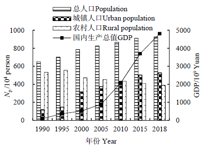
图2 1990—2018年研究区域人口数量(Np)与国内生产总值(GDP)变化
Fig. 2 Dynamic of population and GDP in study area in 1990?2018

图3 1990—2018年海南岛湿地景观生态安全格局演变
Fig. 3 Evolution of wetland landscape ecological security pattern of Hainan Island in 1990?2018
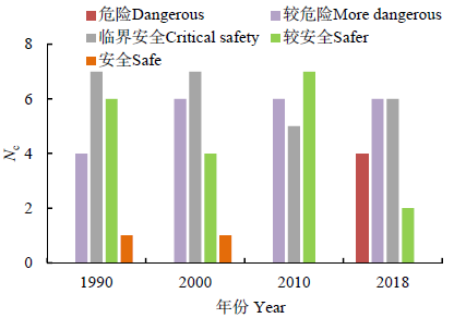
图4 不同安全等级的市县数量(Nc)
Fig. 4 Number of cities with different security level
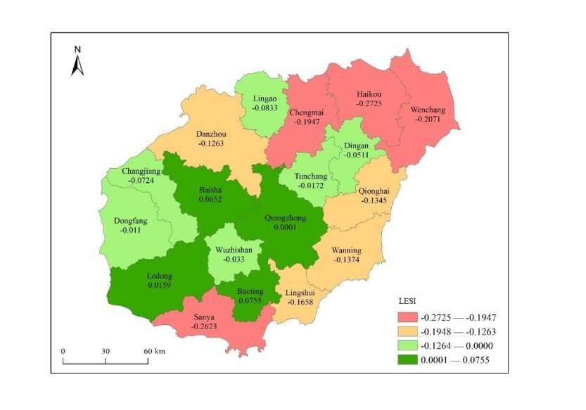
图5 1990—2018年海南岛湿地景观生态安全指数(LESI)变化空间分布
Fig. 5 Spatial distribution of wetland landscape ecological security index of Hainan Island in 1990?2018
| [1] | ALVAREZ G, IRVINE K, VAN GRIENSVEN A, et al., 2013. Relationships between aquatic biotic communities and water quality in a tropical river-wetland system (Ecuador)[J]. Environmental Science & Policy, 34: 115-127. |
| [2] |
BAI Y, JIANG B, WANG M, et al., 2016. New ecological redline policy (ERP) to secure ecosystem services in China[J]. Land Use Policy, 55: 348-351.
DOI URL |
| [3] | BDRINSON M M, ECKLES D, 2011. Department of Agriculture conservation program and practice effects on wetland ecosystem services: a synthesis[J]. Ecological Applications, 21: 116-127. |
| [4] |
COPELAND H E, TESSMAN S A, GIRVETZ E H, et al., 2010. A geospatial assessment on the distribution, condition, and vulnerability of Wyoming's wetlands[J]. Ecological Indicators, 10(4): 869-879.
DOI URL |
| [5] |
DAVRANCHE A, LEFEBVRE G, POULIN B, 2010. Wetland monitoring using classification trees and SPOT-5 seasonal time series[J]. Remote Sensing of Environment, 114(3): 552-562.
DOI URL |
| [6] |
GEDAN K B, KIRWAN M L, WOLANSKI E, 2011. The present and future role of coastal wetland vegetation in protecting shorelines: answering recent challenges to the paradigm[J]. Climatic Change, 106: 7-29.
DOI URL |
| [7] |
HARMÁCKOVÁA Z V, VACKÁR D, 2015. Modelling regulating ecosystem services trade-offs across landscape scenarios in Trebonsko Wetlands Biosphere Reserve, Czech Republic[J]. Ecological Modelling, 295: 207-215.
DOI URL |
| [8] |
JIN H R, HUANG C Q, MEGAN W LANG, et al., 2017. Monitoring of wetland inundation dynamics in the Delmarva Peninsula using Landsat time-series imagery from 1985 to 2011, China[J]. Remote Sensing of Environment, 190: 26-41.
DOI URL |
| [9] |
LI Y F, SUN X, ZHU X D, et al., 2010. An early warning method of landscape ecological security in rapid urbanizing coastal areas and its application in Xiamen, China[J]. Ecological Modelling, 221(19): 2251-2260.
DOI URL |
| [10] |
LIN W P, GEN J W, XU D, et al., 2018. Wetland landscape pattern changes over a period of rapid development (1985-2015) in the ZhouShan Islands of Zhejiang province, China[J]. Estuarine, Coastal and Shelf Science, 213: 148-159.
DOI URL |
| [11] |
MA L B, BO J, LI X Y, et al., 2019. Identifying key landscape pattern indices influencing the ecological security of inland river basin: The middle and lower reaches of Shule River Basin as an example[J]. Science of the Total Environment, 674: 424-438.
DOI URL |
| [12] |
MALEKMOHAMMADI B, JAHANISHAKIB F, 2017. Vulnerability assessment of wetland landscape ecosystem services using driver- pressure-state-impact-response (DPSIR) model[J]. Ecological Indicators, 82: 293-303.
DOI URL |
| [13] |
PICKARD B R, DANIEL J, MEHAFFEY M, et al., 2015. Enviro atlas: a new geospatial tool to foster ecosystem services science and resource management[J]. Ecosystem Services, 14: 45-55.
DOI URL |
| [14] |
SUN N, ZHU W, CHENG Q, 2018. GF-1 and Landsat observed a 40-year wetland spatiotemporal variation and its coupled environmental factors in Yangtze River estuary[J]. Estuarine, Coastal and Shelf Science, 207: 30-39.
DOI URL |
| [15] |
WANG S D, ZHANG X Y, WU T X, et al., 2019. The evolution of landscape ecological security in Beijing under the influence of different policies in recent decades[J]. Science of the Total Environment, 646: 49-57.
DOI URL |
| [16] |
YE H, MA Y, DONG L M, 2011. Land Ecological Security Assessment for Bai Autonomous Prefecture of Dali Based Using PSR Model-with Data in 2009 as Case[J]. Energy Procedia, 5: 2172-2177.
DOI URL |
| [17] |
ZORRILLA-MIRAS P, PALOMO I, GÓMEZ-BAGGETHUN E, et al., 2014. Effects of land-use change on wetland ecosystem services: A case study in the Doñana marshes (SW Spain)[J]. Landscape and Urban Planning, 122: 160-174.
DOI URL |
| [18] | 陈昆仑, 齐漫, 王旭, 等, 2019. 1995-2015年武汉城市湖泊景观生态安全格局演化[J]. 生态学报, 39(5): 1725-1734. |
| CHEN K L, QI M, WANG X, et al., 2019. Study of urban lake landscape ecological security pattern evolution in Wuhan, 1995-2015 [J]. Acta Ecologica Sinica, 39(5): 1725-1734. | |
| [19] | 陈星, 周成虎, 2005. 生态安全: 国内外研究综述[J]. 地理科学进展, 24(6): 8-20. |
| CHEN X, ZHOU C H, 2005. Review of the studies on ecologieal seuirty[J]. Progress in Geography, 24(6): 8-20. | |
| [20] | 杜培军, 陈宇, 谭琨, 2014. 湿地景观格局与生态安全遥感监测分析--以江苏滨海湿地为例[J]. 国土资源遥感, 26(1): 158-166. |
| DU P J, CHEN Y, TAN K, 2014. Monitoring and analyzing wetland landscape pattern change and ecological security using remote sensing images: A case study of Jiangsu coastal wetland[J]. Remote Sensing For Land and Resources, 26(1): 158-166 | |
| [21] | 宫兆宁, 张翼然, 宫辉力, 等, 2011. 北京湿地景观格局演变特征与驱动机制分析[J]. 地理学报, 66(1): 77-88. |
| GONG Z N, ZHANG Y R, GONG H L, et al., 2011. Evolution of wetland landscape pattern and its driving factors in Beijing[J]. Acta Geographica Sinica, 66(1): 77-88. | |
| [22] | 国家林业局, 2015a. 中国湿地资源[M]. 总卷. 北京: 中国林业出版社. |
| State forestry administration, 2015. China wetland resources[M]. Total volume. Beijing: China forestry press. | |
| [23] | 国家林业局, 2015b. 中国湿地资源[M]. 海南卷. 北京: 中国林业出版社. |
| State forestry administration, 2015. China wetland resources[M]. Hainan volume. Beijing: China forestry press. | |
| [24] | 国家林业局湿地保护管理中心, 2013. 中国国际重要湿地生态状况评价公报[R]. 北京: 国家林业局. |
| Wetland Conservation and Management Center, State Forestry Administration, 2013. Evaluation bulletin on ecological status of China's wetlands of international importance[M]. Beijing: State Forestry Administration. | |
| [25] |
侯鹏, 翟俊, 曹巍, 等, 2018. 国家重点生态功能区生态状况变化与保护成效评估--以海南岛中部山区国家重点生态功能区为例[J]. 地理学报, 73(3): 429-441.
DOI |
| HOU P, ZHAI J, CAO W, et al., 2018. Evaluation on ecosystem changes and protection of the national key ecological function zones in mountainous areas of central Hainan Island[J]. Acta Geographica Sinica, 73(3): 429-441. | |
| [26] | 雷金睿, 陈宗铸, 吴庭天, 等, 2019. 1989-2015年海口城市热环境与景观格局的时空演变及其相互关系[J]. 中国环境科学, 39(4): 1734-1743. |
| LEI J R, CHEN Z Z, WU T T, et al., 2019. Spatio-temporal evolution and interrelationship between thermal environment and landscape patterns of Haikou city, 1989-2015 [J]. China Environmental Science, 39(4): 1734-1743. | |
| [27] | 李月臣, 2008. 中国北方13省市区生态安全动态变化分析[J]. 地理研究, 27(5): 1150-1160. |
| LI Y C, 2008. The dynamic changes of ecological security in northern China[J]. Geographical Research, 27(5): 1150-1160. | |
| [28] | 李悦, 袁若愚, 刘洋, 等, 2019. 基于综合权重法的青岛市湿地生态安全评价[J]. 生态学杂志, 38(3): 847-855. |
| LI Y, YUAN R Y, LIU Y, et al., 2019. Ecological security evaluation of wetlands in Qingdao -based on the comprehensive weighting method[J]. Chinese Journal of Ecology, 38(3): 847-855. | |
| [29] |
廖柳文, 秦建新, 2016. 环长株潭城市群湿地生态安全研究[J]. 地球信息科学学报, 18(9): 1217-1226.
DOI |
| LIAO L W, QIN J X, 2016. Ecological security of wetland in Chang-Zhu-Tan urban agglomeration[J]. Journal of Geo-information Science, 18(9): 1217-1226. | |
| [30] |
刘吉平, 董春月, 盛连喜, 等, 2016. 1955-2010年小三江平原沼泽湿地景观格局变化及其对人为干扰的响应[J]. 地理科学, 36(6): 879-887.
DOI |
| LIU J P, DONG C Y, SHENG L X, et al., 2016. Landscape pattern change of the marsh and its response to human disturbance in the Small Sanjiang Plain, 1955-2010 [J]. Scientia Geographica Sinica, 36(6): 879-887. | |
| [31] |
刘吉平, 梁晨, 马长迪, 2018. 孤立湿地功能研究进展[J]. 地理科学, 38(8): 1357-1363.
DOI |
| LIU J P, LIANG C, MA C D, 2018. The prospect for study on isolated wetland functions[J]. Scientia Geographica Sinica, 38(8): 1357-1363. | |
| [32] | 刘艳艳, 吴大放, 王朝晖, 2011. 湿地生态安全评价研究进展[J]. 地理与地理信息科学, 27(1): 69-75. |
| LIU Y Y, WU D F, WANG Z H, 2011. Research review on ecological security assessment of wetland[J]. Geography and Geo-Information Scienc, 27(1): 69-75. | |
| [33] |
吕建树, 吴泉源, 张祖陆, 等, 2012. 基于RS和GIS的济宁市土地利用变化及生态安全研究[J]. 地理科学, 32(8): 928-935.
DOI |
| LU J S, WU Q Y, ZHANG Z L, et al., 2012. Land use change and ecological security assessment in Jining city based on RS and GIS[J]. Scientia Geographica Sinica, 32(8): 928-935. | |
| [34] | 庞雅颂, 王琳, 2014. 区域生态安全评价方法综述[J]. 中国人口·资源与环境, 24(3): 340-344. |
| PANG Y S, WANG L, 2014. A review of regional Ecological Security Evaluation[J]. China Population, Resources and Environment, 24(3): 340-344. | |
| [35] | 钱逸凡, 刘道平, 楼毅, 等, 2019. 我国湿地生态状况评价研究进展[J]. 生态学报, 39(9): 3372-3382. |
| QIAN Y F, LIU P D, LOU Y, et al., 2019. A review of wetland ecological status evaluation in China[J]. Acta Ecologica Sinica, 39(9): 3372-3382. | |
| [36] |
时卉, 杨兆萍, 韩芳, 等, 2013. 新疆天池景区生态安全度时空分异特征与驱动机制[J]. 地理科学进展, 32(3): 475-485.
DOI |
|
SHI H, YANG Z P, HAN F, et al., 2013. Characteristics of temporal-spatial differences in landscape ecological security and the driving mechanism in Tianchi scenic zone of Xinjiang[J]. Progress in Geography, 32(3): 475-485.
DOI |
|
| [37] | 宋豫秦, 曹明兰, 2010. 基于RS和GIS的北京市景观生态安全评价[J]. 应用生态学报, 21(11): 2889-2895. |
| SONG Y Q, CAO M L, 2010. Landscape ecological security assessment of Beijing city based on RS and GIS[J]. Chinese Journal of Applied Ecology, 21(11): 2889-2895. | |
| [38] | 隋燕, 张丽, 穆晓东, 等, 2018. 海南岛海岸线变迁遥感监测与分析[J]. 海洋学研究, 36(2): 36-43. |
| SUI Y, ZHANG L, MU X D, et al., 2018. Coastline change monitoring and analysis with remote sensing in Hainan Island[J]. Journal of Marine Sciences, 36(2): 36-43. | |
| [39] | 王泉泉, 王行, 张卫国, 等, 2019. 滇西北高原湿地景观变化与人为、自然因子的相关性[J]. 生态学报, 39(2): 726-738. |
| WANG Q Q, WANG H, ZHANG W G, et al., 2019. The correlations between wetland landscape and social-natural factors on Northwestern Yunnan Plateau[J]. Acta Ecologica Sinica, 39(2): 726-738. | |
| [40] | 邬建国, 2007. 景观生态学--格局、过程、尺度与等级[M]. 第2版. 北京: 高等教育出版社. |
| WU J G, 2007. Landscape ecology - pattern, process, scale and rank[M]. 2nd edition. Beijing: Higher Education Press. | |
| [41] | 吴健生, 张茜, 曹祺文, 2017. 快速城市化地区湿地生态安全评价--以深圳市为例[J]. 湿地科学, 15(3): 321-328. |
| WU J S ZHANG X, CAO Q W, 2017. Ecological security assessment of wetlands in rapidly urbanizing areas: a case study of Shenzhen, China[J]. Wetland Science, 15(3): 321-328. | |
| [42] | 吴文挺, 田波, 周云轩, 等, 2016. 中国海岸带围垦遥感分析[J]. 生态学报, 36(16): 5007-5016. |
| WU W T, TIAN B, ZHOU Y X, et al., 2016. The trends of coastal reclamation in China in the past three decades[J]. Acta Ecologica Sinica, 36(16): 5007-5016. | |
| [43] |
谢余初, 巩杰, 张玲玲, 2015. 基于PSR模型的白龙江流域景观生态安全时空变化[J]. 地理科学, 35(6): 790-797.
DOI |
| XIE Y C, GONG J, ZHANG L L, 2015. Dynamics of landscape ecological security based on PSR model in the Bailongjiang riverwatershed[J]. Scientia Geographica Sinica, 35(6): 790-797. | |
| [44] | 杨永兴, 2002. 国际湿地科学研究的主要特点、进展与展望[J]. 地理科学进展, 21(2): 111-120. |
| YANG Y X, 2002. Main characteristics, progress and prospect of international wetland science research[J]. Progress in Geography, 21(2): 111-120. | |
| [45] | 张猛, 曾永年, 2018. 长株潭城市群湿地景观时空动态变化及驱动力分析[J]. 农业工程学报, 34(1): 241-249. |
| ZHANG M, ZENG Y N, 2018. Temporal and spatial dynamic changes and driving forces analysis of wetland landscape of Chang-Zhu-Tan urban agglomeration[J]. Transactions of the Chinese Society of Agricultural Engineering, 34(1): 241-249. | |
| [46] | 朱卫红, 苗承玉, 郑小军, 等, 2014. 基于3S 技术的图们江流域湿地生态安全评价与预警研究[J]. 生态学报, 34(6): 1379-1390. |
| ZHU W H, MIAO C Y, ZHENG X J, et al., 2014. Study on ecological safety evaluation and warning of wetlands in Tumen River watershed based on 3S technology[J]. Acta Ecologica Sinica, 34(6): 1379-1390. | |
| [47] | 邹发生, 宋晓军, 江海声, 等, 1999. 海南岛的湿地类型及其特点[J]. 热带地理, 19(3): 204-207. |
| ZOU F S, SONG X J, JIANG H S, et al., 1999. Types and characteristics of the wetland of Hainan Island[J]. Tropical Geography, 19(3): 204-207. |
| [1] | 许静, 廖星凯, 甘崎旭, 周茅先. 基于MSPA与电路理论的黄河流域甘肃段生态安全格局构建[J]. 生态环境学报, 2023, 32(4): 805-813. |
| [2] | 张平江, 党国锋. 基于MCR模型与蚁群算法的洮河流域生态安全格局构建[J]. 生态环境学报, 2023, 32(3): 481-491. |
| [3] | 韦家怡, 李铖, 吴志峰, 张莉, 吉冬青, 程炯. 粤港澳大湾区生态安全格局及重要生态廊道识别[J]. 生态环境学报, 2022, 31(4): 652-662. |
| [4] | 魏建兵, 郑泓, 程雨露, 王阳. 基于CiteSpace的生态安全格局研究进展[J]. 生态环境学报, 2022, 31(4): 835-844. |
| [5] | 易浪, 孙颖, 尹少华, 魏晓. 生态安全格局构建:概念、框架与展望[J]. 生态环境学报, 2022, 31(4): 845-856. |
| [6] | 齐静, 邓伟, 周渝, 刘婷, 罗旭. 重庆市生态保护红线成效评估方法与应用[J]. 生态环境学报, 2021, 30(7): 1532-1540. |
| [7] | 雷金睿, 陈宗铸, 陈毅青, 陈小花, 李苑菱, 吴庭天. 1990—2018年海南岛湿地景观格局演变及其驱动力分析[J]. 生态环境学报, 2020, 29(1): 59-70. |
| 阅读次数 | ||||||
|
全文 |
|
|||||
|
摘要 |
|
|||||