Ecology and Environmental Sciences ›› 2025, Vol. 34 ›› Issue (10): 1618-1632.DOI: 10.16258/j.cnki.1674-5906.2025.10.012
• Research Article [Environmental Science] • Previous Articles Next Articles
ZHANG Xiaoqing1( ), LIAO Xingyue1, LI Guo2,*(), REN Dajun1, ZHANG Shuqin1
Received:2025-02-19
Online:2025-10-18
Published:2025-09-26
张晓晴1(), 廖星月1, 李果2,*(), 任大军1, 张淑琴1
通讯作者:
E-mail: 作者简介:张晓晴(1984年生),女,教授,硕士研究生导师,主要从事生态环境风险及污染防治研究工作。E-mail: zhangxiaoqing@wust.edu.cn
基金资助:CLC Number:
ZHANG Xiaoqing, LIAO Xingyue, LI Guo, REN Dajun, ZHANG Shuqin. Assessment of Water Ecological Security and Future Trend Projection for Urban Agglomerations along the Main Stream of the Yangtze River in Hubei Province Based on the DPSIR Model[J]. Ecology and Environmental Sciences, 2025, 34(10): 1618-1632.
张晓晴, 廖星月, 李果, 任大军, 张淑琴. 基于DPSIR模型的湖北省长江干流城市群水生态安全评估及未来趋势预测[J]. 生态环境学报, 2025, 34(10): 1618-1632.
Add to citation manager EndNote|Ris|BibTeX
URL: https://www.jeesci.com/EN/10.16258/j.cnki.1674-5906.2025.10.012
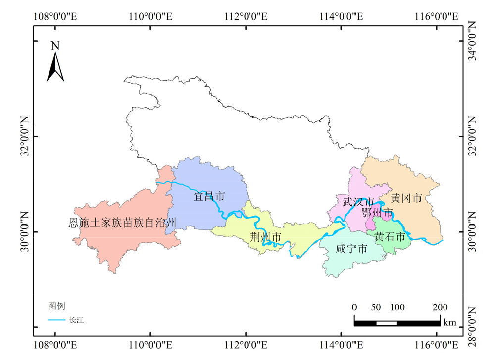
Figure 1 The studied area
| 准则层 | 研究区域 | 参考文献 | ||||
|---|---|---|---|---|---|---|
| 驱动力(D) | 压力(P) | 状态(S) | 影响(I) | 响应(R) | ||
| 人口自然增长率,年末常住人口总数,地区生产总值,人均GDP,GDP增长率 | 用水总量,人均用水量,生态用水,万元GDP用水量,废水排放量,COD排放量,NH3-N排放量 | 水资源总量,人均水资源占有量,地表水资源量,地下水资源量,年平均降水量 | 沙化土地面积,森林覆盖率,劣Ⅴ类以下河段比例,城市水功能区个数达标率 | 城市污水处理率,工业废水治理投资额,节水灌溉面积,累计除涝面积,累计水土流失治理面积,污水处理投资额 | 西北地区 | 曹源圆, |
| 人口自然增长率,人均GDP,城镇化率,农林牧渔总产值,工业增加值 | 万元工业增加值用水量,生活用水量,万元GDP用水量,人均用水量,万元工业增加值废水排放量 | 产水规模,人均水资源量,年降水总量 | 湿地面积,有效灌溉面积,生态用水量 | 累积达标堤防,水土流失治理面积,污水处理总量,城市污水处理率 | 湖南省 | 付丽娜等, |
| GDP增长率,人口自然增长率,单位面积水资源量,万元工业产值用水量 | 农业用水率,生态用水率,人均日生活用水量,万元产值废污水排放量 | 人均水资源量,水资源利用率,水质监测断面达标比例,人均GDP,恩格尔系数,森林覆盖率,城市化率 | 建成区绿化覆盖率,第三产业增加值比重,用水普及率 | 城市生活污水处理率,工业固废综合利用率,水利及公共设施投资占比,万人在校大学生数 | 陕西省 | 郭嘉嘉等, |
| 总人口,城镇化率,人均GDP,城镇常住人口人均可支配收入,工业增加值,农林牧渔业增加值 | 工业用水量,生活用水量,农田灌溉用水量,万元GDP用水量,万元工业增加值用水量 | 生活污水排放量,工业废水排放量,总磷排放量,废水中氨氮排放量,COD排放量,市政工程污水处理率,排入污水处理厂的工业废水排放总量,人均水资源量,总供水量 | 生态环境用水量,中水回用率,产水系数,年生态基流满足率 | 生态保护红线面积比指数,水生生物多样性指数,自然岸线比例,湿地面积,自然保护区面积,绿化覆盖面积,饮用水源水质达标率,水功能区水质达标率 | 安徽省芜湖市 | 卢开东等, |
| 人口自然增长率,年末常住人口,人均生产总值,第三产业比例,建成区面积,城镇化率 | 废水排放总量,工业废水排放量,洪涝台旱灾害受灾面积,森林覆盖率,用水总量,工业用水量,总耗水量,农田灌溉用水量 | 地表水环境功能区水质达标率,地表水Ⅰ-Ⅲ类水质断面比例,降水量,大中型水库年末蓄水总量,产水模数,平均耗水率,平均水资源利用率 | 劣Ⅴ类水质断面比例,集中式饮用水源地水质达标率,洪涝台旱灾害受灾人口,洪涝台旱灾害直接经济损失,用水普及率,村庄供水普及率,农田灌溉单位面积平均用水量,单位GDP用水量 | 城市污水处理率,污水处理总能力,除涝面积,堤塘长度,供水综合生产能力,供水管道长度,工业用水重复利用率,节水灌溉面积 | 浙江省 | 申开丽等, |
| 人均GDP,人口密度,城镇化率,人口增长率 | 地表水供量,地下水开采量,污水排放量,工业总产值增长速度,农业灌溉面积 | 年降水量,地表水资源量,地下水资源量 | 水资源利用率,浅层地下水污染比例,劣五类河长占比,水功能区达标率 | 全市蓄水总量,污水处理率,节能环保支出占公共预算支出比重 | 吉林省长春市 | 朱逸凡等, |
| 人均GDP,第三产业占GDP比重,第二产业占GDP比重,人口自然增长率,人口密度,单位面积卫生机构床位数 | 万元工业增加值用水量,万元GDP用水量,单位面积COD排放量,人均用水量,单位面积氨氮排放量,灌溉面积,人均综合用水量 | 水功能区达标率,耕地面积减少比例,工业废水排放量,酸雨发生率 | 单位面积平均产量,农业用电量,Ⅰ-Ⅲ类水比例 | 灌溉水利系数,农民可支配收入,农业用水比例,生态用水比例,单位面积平均用水量 | 江淮 生态大走廊 | 杨婷,2021 |
| GDP增长率,农林牧渔总产值,人均水资源量,城镇化率,人口自然增长率,第二产业占GDP比重,第三产业占GDP比重 | 万元GDP用水量,万元工业增加值用水量,生活用水量,人均用水量,工业废水排放量 | 年降水量,产水模数,总供水量,地下水资源量,地表水资源量,大中型水库年末蓄水量 | 生态环境用水量,人均公园绿地面积,建成区绿化覆盖率,农民可支配收入 | 污水处理总量,城市污水集中处理率 | 湖北省长江 干流 城市群 | 本研究 |
Table 1 Selected water ecological security indicators in previous and current studies under the DPSIR framework
| 准则层 | 研究区域 | 参考文献 | ||||
|---|---|---|---|---|---|---|
| 驱动力(D) | 压力(P) | 状态(S) | 影响(I) | 响应(R) | ||
| 人口自然增长率,年末常住人口总数,地区生产总值,人均GDP,GDP增长率 | 用水总量,人均用水量,生态用水,万元GDP用水量,废水排放量,COD排放量,NH3-N排放量 | 水资源总量,人均水资源占有量,地表水资源量,地下水资源量,年平均降水量 | 沙化土地面积,森林覆盖率,劣Ⅴ类以下河段比例,城市水功能区个数达标率 | 城市污水处理率,工业废水治理投资额,节水灌溉面积,累计除涝面积,累计水土流失治理面积,污水处理投资额 | 西北地区 | 曹源圆, |
| 人口自然增长率,人均GDP,城镇化率,农林牧渔总产值,工业增加值 | 万元工业增加值用水量,生活用水量,万元GDP用水量,人均用水量,万元工业增加值废水排放量 | 产水规模,人均水资源量,年降水总量 | 湿地面积,有效灌溉面积,生态用水量 | 累积达标堤防,水土流失治理面积,污水处理总量,城市污水处理率 | 湖南省 | 付丽娜等, |
| GDP增长率,人口自然增长率,单位面积水资源量,万元工业产值用水量 | 农业用水率,生态用水率,人均日生活用水量,万元产值废污水排放量 | 人均水资源量,水资源利用率,水质监测断面达标比例,人均GDP,恩格尔系数,森林覆盖率,城市化率 | 建成区绿化覆盖率,第三产业增加值比重,用水普及率 | 城市生活污水处理率,工业固废综合利用率,水利及公共设施投资占比,万人在校大学生数 | 陕西省 | 郭嘉嘉等, |
| 总人口,城镇化率,人均GDP,城镇常住人口人均可支配收入,工业增加值,农林牧渔业增加值 | 工业用水量,生活用水量,农田灌溉用水量,万元GDP用水量,万元工业增加值用水量 | 生活污水排放量,工业废水排放量,总磷排放量,废水中氨氮排放量,COD排放量,市政工程污水处理率,排入污水处理厂的工业废水排放总量,人均水资源量,总供水量 | 生态环境用水量,中水回用率,产水系数,年生态基流满足率 | 生态保护红线面积比指数,水生生物多样性指数,自然岸线比例,湿地面积,自然保护区面积,绿化覆盖面积,饮用水源水质达标率,水功能区水质达标率 | 安徽省芜湖市 | 卢开东等, |
| 人口自然增长率,年末常住人口,人均生产总值,第三产业比例,建成区面积,城镇化率 | 废水排放总量,工业废水排放量,洪涝台旱灾害受灾面积,森林覆盖率,用水总量,工业用水量,总耗水量,农田灌溉用水量 | 地表水环境功能区水质达标率,地表水Ⅰ-Ⅲ类水质断面比例,降水量,大中型水库年末蓄水总量,产水模数,平均耗水率,平均水资源利用率 | 劣Ⅴ类水质断面比例,集中式饮用水源地水质达标率,洪涝台旱灾害受灾人口,洪涝台旱灾害直接经济损失,用水普及率,村庄供水普及率,农田灌溉单位面积平均用水量,单位GDP用水量 | 城市污水处理率,污水处理总能力,除涝面积,堤塘长度,供水综合生产能力,供水管道长度,工业用水重复利用率,节水灌溉面积 | 浙江省 | 申开丽等, |
| 人均GDP,人口密度,城镇化率,人口增长率 | 地表水供量,地下水开采量,污水排放量,工业总产值增长速度,农业灌溉面积 | 年降水量,地表水资源量,地下水资源量 | 水资源利用率,浅层地下水污染比例,劣五类河长占比,水功能区达标率 | 全市蓄水总量,污水处理率,节能环保支出占公共预算支出比重 | 吉林省长春市 | 朱逸凡等, |
| 人均GDP,第三产业占GDP比重,第二产业占GDP比重,人口自然增长率,人口密度,单位面积卫生机构床位数 | 万元工业增加值用水量,万元GDP用水量,单位面积COD排放量,人均用水量,单位面积氨氮排放量,灌溉面积,人均综合用水量 | 水功能区达标率,耕地面积减少比例,工业废水排放量,酸雨发生率 | 单位面积平均产量,农业用电量,Ⅰ-Ⅲ类水比例 | 灌溉水利系数,农民可支配收入,农业用水比例,生态用水比例,单位面积平均用水量 | 江淮 生态大走廊 | 杨婷,2021 |
| GDP增长率,农林牧渔总产值,人均水资源量,城镇化率,人口自然增长率,第二产业占GDP比重,第三产业占GDP比重 | 万元GDP用水量,万元工业增加值用水量,生活用水量,人均用水量,工业废水排放量 | 年降水量,产水模数,总供水量,地下水资源量,地表水资源量,大中型水库年末蓄水量 | 生态环境用水量,人均公园绿地面积,建成区绿化覆盖率,农民可支配收入 | 污水处理总量,城市污水集中处理率 | 湖北省长江 干流 城市群 | 本研究 |
| 准则层 | 指标 | 指标性质 | 权重 |
|---|---|---|---|
| 驱动力指标(D) | GDP增长率(D1) | 正 | 0.01 |
| 人均GDP(D2) | 正 | 0.04 | |
| 农林牧渔总产值(D3) | 正 | 0.04 | |
| 人均水资源量(D4) | 正 | 0.05 | |
| 城镇化率(D5) | 正 | 0.01 | |
| 人口自然增长率(D6) | 负 | 0.01 | |
| 第二产业占GDP比重(D7) | 负 | 0.03 | |
| 第三产业占GDP比重(D8) | 正 | 0.04 | |
| 压力指标(P) | 万元GDP用水量(P1) | 负 | 0.01 |
| 万元工业增加值用水量(P2) | 负 | 0.01 | |
| 生活用水量(P3) | 负 | 0.01 | |
| 人均用水量(P4) | 负 | 0.01 | |
| 工业废水排放量(P5) | 负 | 0.01 | |
| 状态指标(S) | 年降水量(S1) | 正 | 0.03 |
| 产水模数(S2) | 正 | 0.04 | |
| 总供水量(S3) | 正 | 0.04 | |
| 地下水资源量(S4) | 正 | 0.05 | |
| 地表水资源量(S5) | 正 | 0.06 | |
| 大中型水库年末蓄水量(S6) | 正 | 0.08 | |
| 影响指标(I) | 生态环境用水量(I1) | 正 | 0.22 |
| 人均公园绿地面积(I2) | 正 | 0.01 | |
| 建成区绿化覆盖率(I3) | 正 | 0.01 | |
| 农民可支配收入(I4) | 正 | 0.03 | |
| 响应指标(R) | 污水处理总量(R1) | 正 | 0.17 |
| 城市污水集中处理率(R2) | 正 | 0.01 |
Table 2 Water ecosystem security assessment
| 准则层 | 指标 | 指标性质 | 权重 |
|---|---|---|---|
| 驱动力指标(D) | GDP增长率(D1) | 正 | 0.01 |
| 人均GDP(D2) | 正 | 0.04 | |
| 农林牧渔总产值(D3) | 正 | 0.04 | |
| 人均水资源量(D4) | 正 | 0.05 | |
| 城镇化率(D5) | 正 | 0.01 | |
| 人口自然增长率(D6) | 负 | 0.01 | |
| 第二产业占GDP比重(D7) | 负 | 0.03 | |
| 第三产业占GDP比重(D8) | 正 | 0.04 | |
| 压力指标(P) | 万元GDP用水量(P1) | 负 | 0.01 |
| 万元工业增加值用水量(P2) | 负 | 0.01 | |
| 生活用水量(P3) | 负 | 0.01 | |
| 人均用水量(P4) | 负 | 0.01 | |
| 工业废水排放量(P5) | 负 | 0.01 | |
| 状态指标(S) | 年降水量(S1) | 正 | 0.03 |
| 产水模数(S2) | 正 | 0.04 | |
| 总供水量(S3) | 正 | 0.04 | |
| 地下水资源量(S4) | 正 | 0.05 | |
| 地表水资源量(S5) | 正 | 0.06 | |
| 大中型水库年末蓄水量(S6) | 正 | 0.08 | |
| 影响指标(I) | 生态环境用水量(I1) | 正 | 0.22 |
| 人均公园绿地面积(I2) | 正 | 0.01 | |
| 建成区绿化覆盖率(I3) | 正 | 0.01 | |
| 农民可支配收入(I4) | 正 | 0.03 | |
| 响应指标(R) | 污水处理总量(R1) | 正 | 0.17 |
| 城市污水集中处理率(R2) | 正 | 0.01 |
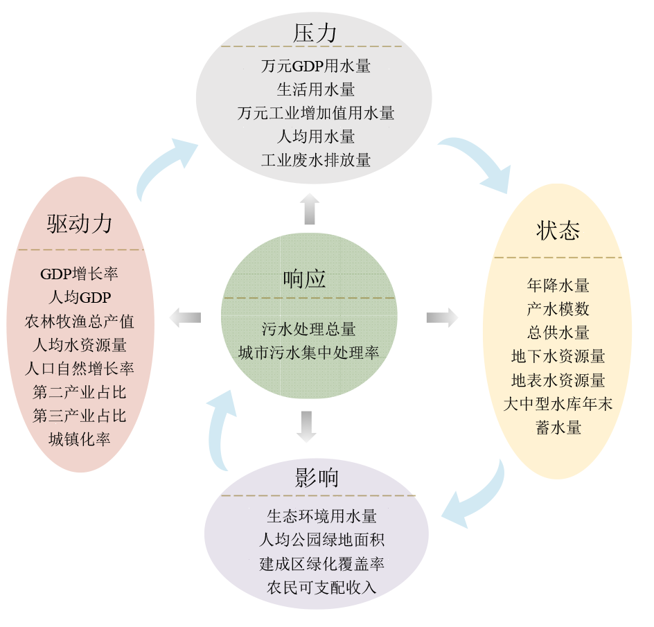
Figure 2 DPSIR model framework
| 水生态安全综合得分 | 0-0.20 | 0.20-0.40 | 0.40-0.60 | 0.60-0.80 | 0.80-1.00 |
|---|---|---|---|---|---|
| 等级 | Ⅰ | Ⅱ | Ⅲ | Ⅳ | Ⅴ |
| 状态 | 重度警告 | 中度警告 | 预警 | 较安全 | 安全 |
Table 3 Classification of water ecological safety evaluation grades
| 水生态安全综合得分 | 0-0.20 | 0.20-0.40 | 0.40-0.60 | 0.60-0.80 | 0.80-1.00 |
|---|---|---|---|---|---|
| 等级 | Ⅰ | Ⅱ | Ⅲ | Ⅳ | Ⅴ |
| 状态 | 重度警告 | 中度警告 | 预警 | 较安全 | 安全 |
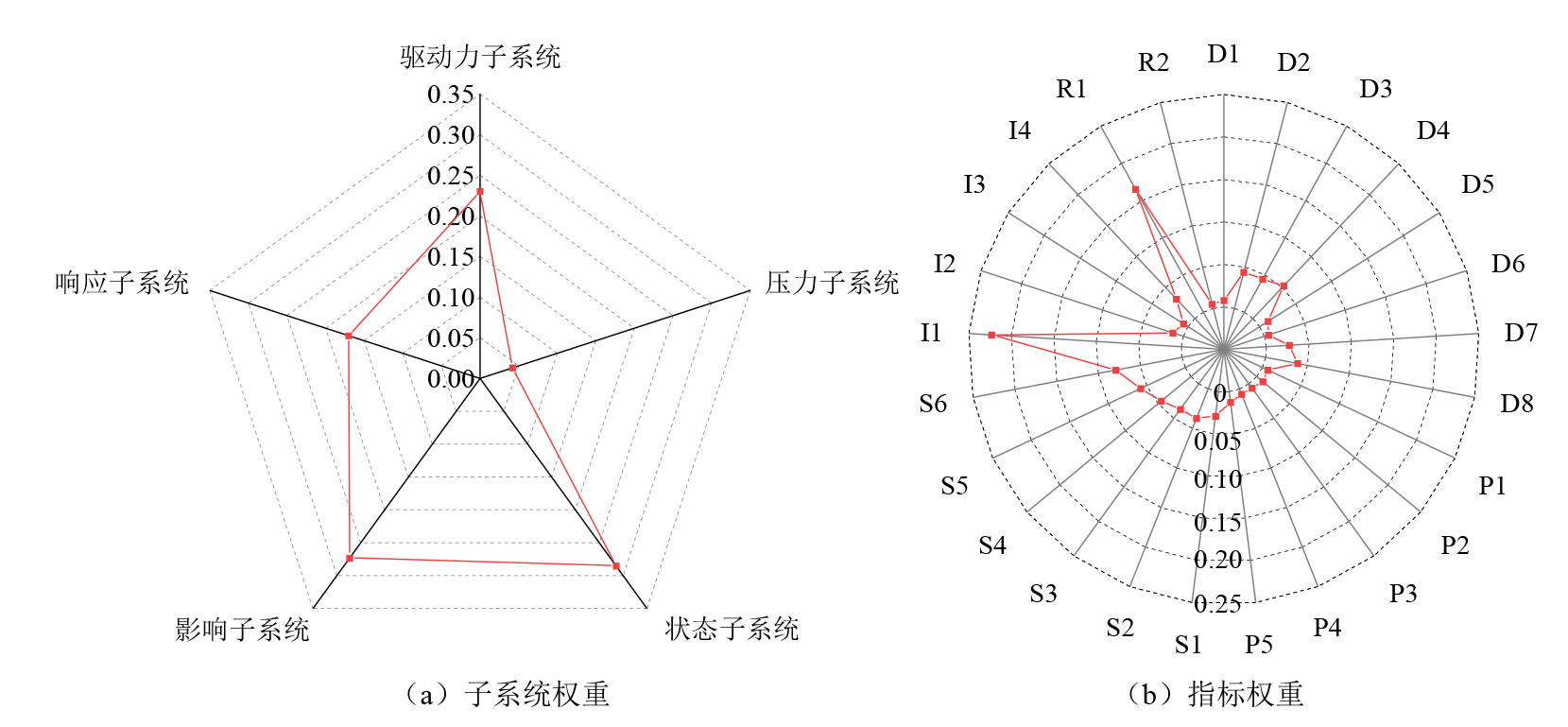
Figure 3 Weighting of the impact of subsystems and indicators on water ecosystem security
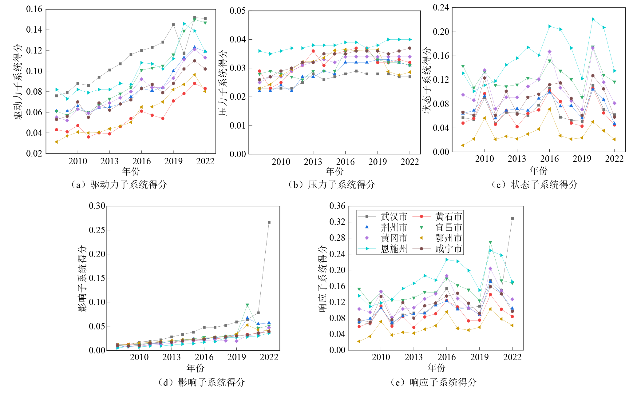
Figure 4 Assessment of water ecosystem subsystem of urban agglomeration of Yangtze River Basin in Hubei Province
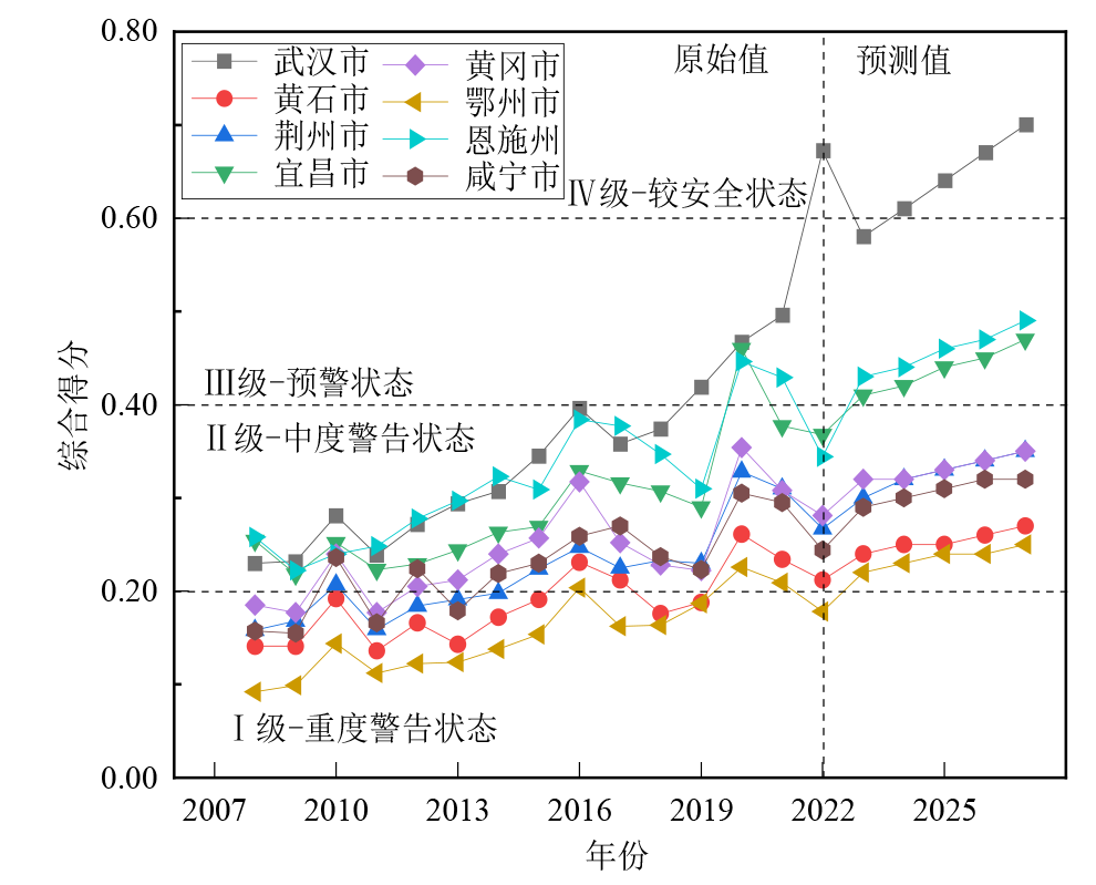
Figure 5 Comprehensive assessment of water ecological safety in urban agglomerations on the mainstream of the Yangtze River in Hubei Province
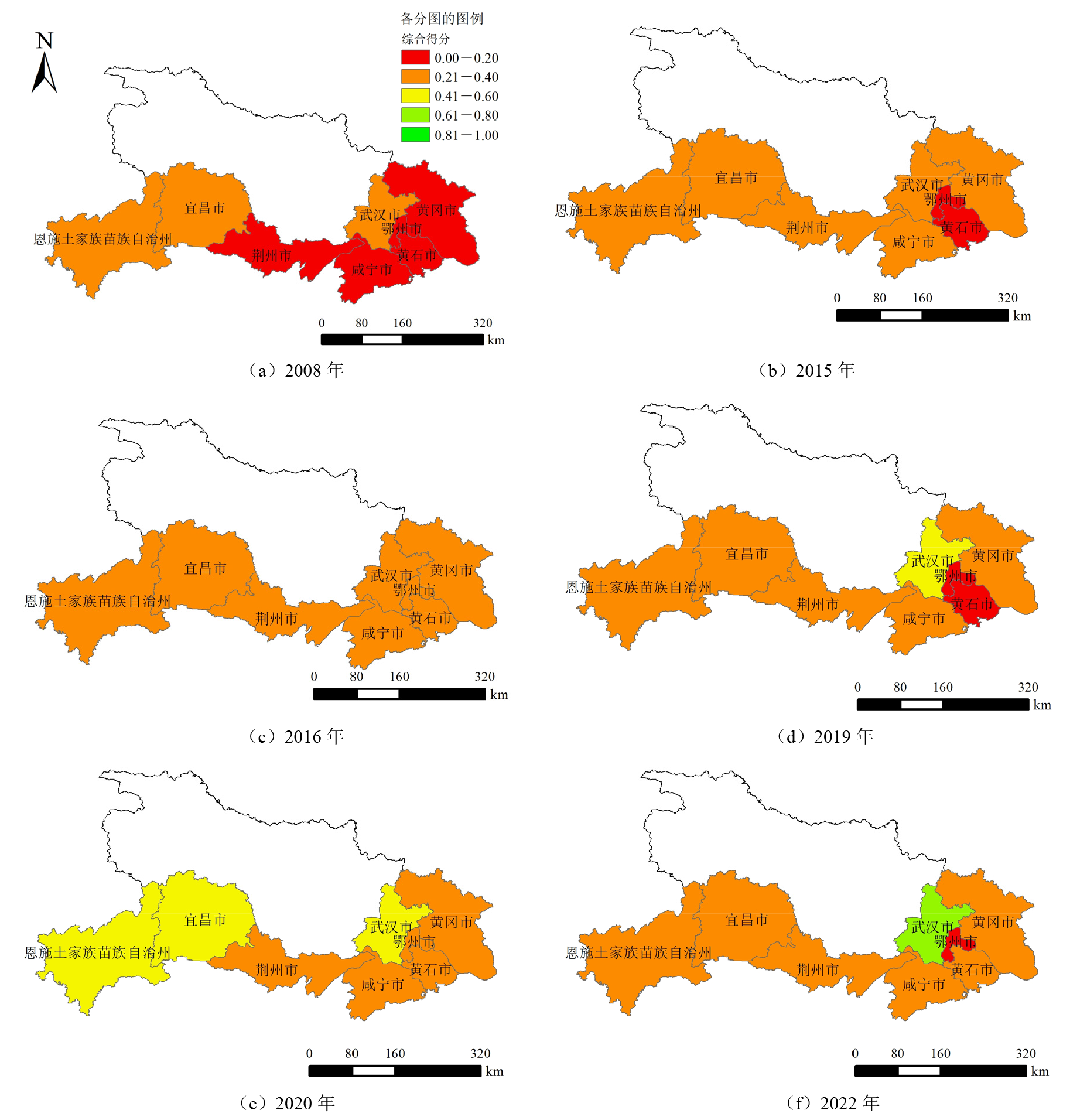
Figure 6 Spatial distribution of water ecological safety in urban agglomerations on the mainstream of the Yangtze River in Hubei Province
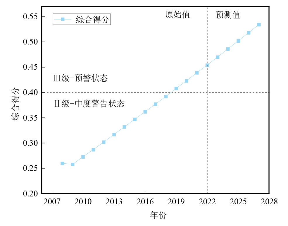
Figure 7 Comprehensive assessment of water ecological safety in urban agglomerations on the mainstream of the Yangtze River in Hubei Province
| 地区 | p | 精度等级 | 后验差比(C) | 精度等级 |
|---|---|---|---|---|
| 武汉市 | 0.93 | 好 | 0.14 | 优良 |
| 黄石市 | 0.71 | 可以接受 | 0.41 | 好 |
| 荆州市 | 0.87 | 好 | 0.24 | 优良 |
| 宜昌市 | 0.87 | 好 | 0.27 | 优良 |
| 黄冈市 | 0.70 | 可以接受 | 0.46 | 好 |
| 鄂州市 | 0.73 | 可以接受 | 0.23 | 优良 |
| 恩施州 | 0.73 | 可以接受 | 0.29 | 优良 |
| 咸宁市 | 0.71 | 可以接受 | 0.38 | 好 |
| 湖北省 | 0.73 | 可以接受 | 0.31 | 优良 |
Table 4 The test table for predicting water ecological safety of urban agglomerations on the Yangtze River mainstem in Hubei Province
| 地区 | p | 精度等级 | 后验差比(C) | 精度等级 |
|---|---|---|---|---|
| 武汉市 | 0.93 | 好 | 0.14 | 优良 |
| 黄石市 | 0.71 | 可以接受 | 0.41 | 好 |
| 荆州市 | 0.87 | 好 | 0.24 | 优良 |
| 宜昌市 | 0.87 | 好 | 0.27 | 优良 |
| 黄冈市 | 0.70 | 可以接受 | 0.46 | 好 |
| 鄂州市 | 0.73 | 可以接受 | 0.23 | 优良 |
| 恩施州 | 0.73 | 可以接受 | 0.29 | 优良 |
| 咸宁市 | 0.71 | 可以接受 | 0.38 | 好 |
| 湖北省 | 0.73 | 可以接受 | 0.31 | 优良 |
| [1] | AALIREZAEI A, KHAN M S A, KABIR G, et al., 2021. Prediction of water security level for achieving sustainable development objectives in Saskatchewan, Canada: Implications for resource conservation in developed economies[J]. Journal of Cleaner Production, 311: 127521. |
| [2] | BAI Y, QIN J M, LIU W J, et al., 2024. The DPSIR model-based sustainability assessment of urban water resources: A comparative study of Zhuhai and Macao[J]. Water, 16(10): 1413. |
| [3] | DU Y B, TU Y, LI Z M, et al., 2022. Regional water resources security grading evaluation considering both visible and virtual water: A case study on Hubei province, China[J]. Environmental Science and Pollution Research, 29(17): 25824-25847. |
| [4] | GARI S R, NEWTON A, ICELY J D, 2015. A review of the application and evolution of the DPSIR framework with an emphasis on coastal social-ecological systems[J]. Ocean and Coastal Management, 103: 63-77. |
| [5] | HE N, ZHOU Z H, ZHOU Y, et al., 2024. Spatiotemporal changes and drivers of ecological security based on an improved ecological footprint model: The case of Hubei Province, China[J]. Environmental Research Letters, 19(6): 064049. |
| [6] | HUGHES C, WINNAAR G, SCHYLZE R, et al., 2018. Mapping of water-related ecosystem services in the uMngeni catchment using a daily time-step hydrological model for prioritisation of ecological infrastructure investment—Part 1: Context and modelling approach[J]. Water SA, 44(4): 577. |
| [7] | JING X D, TAO S T, HU H, et al., 2024. Spatio-temporal evaluation of ecological security of cultivated land in China based on DPSIR-entropy weight TOPSIS model and analysis of obstacle factors[J]. Ecological Indicators, 166: 112579. |
| [8] | LI J Q, HE W J, JIANG E H, et al., 2024. Evaluation and prediction of water security levels in Northwest China based on the DPSIR model[J]. Ecological Indicators, 163: 112045. |
| [9] | LU M T, WANG S Y, WANG X Y, et al., 2022. An assessment of temporal and spatial dynamics of regional water resources security in the DPSIR framework in Jiangxi Province, China[J]. International Journal of Environmental Research and Public Health, 19(6): 3650. |
| [10] | NIEMEIJER D, GROOT R S, 2008. Framing environmental indicators: Moving from causal chains to causal networks[J]. Environment, Development and Sustainability, 10(1): 89-106. |
| [11] | QIU M, ZUO Q T, WU Q S, et al., 2022. Water ecological security assessment and spatial autocorrelation analysis of prefectural regions involved in the Yellow River Basin[J]. Scientific Reports, 12(1): 5105. |
| [12] | SOBOYEJO L A, SAKINAT A M, BANKOLE A O, 2021. A DPSIR and SAF analysis of water insecurity in Lake Chad Basin, Central Africa[J]. Proceedings of the International Association of Hydrological Sciences, 384: 313-318. |
| [13] | SUN C, WANG X P, ZHANG Y F, 2024b. Ecological health assessment of an arid basin using the DPSIRM model and TOPSIS: A case study of the Shiyang River Basin[J]. Ecological Indicators, 161: 111973. |
| [14] | SUN D Y, JI Z H, WANG Y K, et al., 2024a. Assessment and forecasting of water ecological security and obstacle factor diagnosis in the Hexi Corridor of Northwest China[J]. Scientific Reports, 14(1): 23507. |
| [15] | WANG Z, ZHOU J Q, LOAICIGA H G, et al., 2015. A DPSIR Model for Ecological Security Assessment through Indicator Screening: A case study at Dianchi Lake in China[J]. Public Library of Science One, 10(6): e0131732. |
| [16] | XU Y, YANG L, ZHANG C, et al., 2023. Comprehensive evaluation of water ecological environment in watersheds: A case study of the Yangtze River Economic Belt, China[J]. Environmental Science and Pollution Research, 30(11): 30727-30740. |
| [17] | YANG G M, GUI Q Q, LIU J Y, et al., 2023. Spatial-temporal evolution and driving factors of ecological security in China based on DPSIR-DEA model: A case study of the Three Gorges reservoir area[J]. Ecological Indicators, 154: 110777. |
| [18] | YUAN Z Y, 2022. Water resources carrying capacity of wetland conservation in Dongting[J]. Desalination and Water Treatment, 267: 83-88. |
| [19] | ZHANG J J, HAO X M, LI X W, et al., 2024. Evaluation and regulation strategy for ecological security in the Tarim River Basin based on the ecological footprint[J]. Journal of Cleaner Production, 435: 140488. |
| [20] | ZHANG Y S, WEI Y J, MAO Y, 2023. Sustainability assessment of regional water resources in China based on DPSIR model[J]. Sustainability, 15(10): 8015. |
| [21] | ZHANG Z F, HE W J, AN M, et al., 2019. Water security assessment of China’s One Belt and One Road region[J]. Water, 11(3): 607. |
| [22] | ZHANG Z Y, LIN H B, HAO Z K, et al., 2018. Research on safety diagnosis for water environment based on gray relational analysis: A case study of Taizhou bay[J]. Environmental Protection and Ecology, 19(1): 70-78. |
| [23] | ZHOU J R, LI X Q, YU X, et al., 2024. Exploring the ecological security evaluation of water resources in the Yangtze River Basin under the background of ecological sustainable development[J]. Scientific Reports, 14(1): 15475. |
| [24] | 蔡贤, 杜晓初, 2020. 基于遥感生态指数的鄂州市生态环境质量评估[J]. 湖北大学学报(自然科学版), 42(3): 233-239. |
| CAI X, DU X C, 2020. Assessment of ecological environment quality in Ezhou City based on remote sensing ecological index[J]. Journal of Hubei University: Natural Science, 42(3): 233-239. | |
| [25] | 曹琦, 陈兴鹏, 师满江, 2012. 基于DPSIR概念的城市水资源安全评价及调控[J]. 资源科学, 34(8): 1591-1599. |
| CAO Q, CHEN X P, SHI M J, 2012. Evaluation and regulation of urban water security based on DPSIR concept[J]. Resources Science, 34(8): 1591-1599. | |
| [26] | 曹源圆, 2021. 基于DPSIR模型的西北地区水生态安全评价研究[J]. 水资源开发与管理 (1): 17-23. |
| CAO Y Y, 2021. Evaluation of water ecological security in Northwest China based on DPSIR model[J]. Water Resources Development and Management (1): 17-23. | |
| [27] | 程欣, 杨高升, 2018. 湖北省生态环境绩效评价及预测[J]. 武汉理工大学学报(信息与管理工程版), 40(6): 628-632. |
| CHENG X, YANG G S, 2018. Evaluation and prediction of ecological environment performance in Hubei Province[J]. Journal of Wuhan University of Technology (Information and Management Engineering), 40(6): 628-632. | |
| [28] |
柴林, 袁亮, 何伟军, 等, 2025. 长江经济带水利新质生产力时空分异及提升路径[J]. 资源科学, 47(3): 615-627.
DOI |
|
CHAI L, YUAN L, HE W J, et al., 2025. Spatial and temporal differentiation of new quality productivity of water resources in the Yangtze River economic zone and the path to enhancement[J]. Resources Science, 47(3): 615-627.
DOI |
|
| [29] | 戴文渊, 2021. 基于W-SENCE-PSR框架的河西内陆河流域水生态安全评价研究[D]. 兰州: 甘肃农业大学: 3-10. |
| DAI W Y, 2021. Evaluation of water ecological security in the inland river basin of Hexi based on W-SENCE-PSR framework[D]. Lanzhou: Gansu Agricultural University: 3-10. | |
| [30] | 邓婷, 2018. 长江湖北段绿色廊道的生态安全格局构建[D]. 武汉: 湖北大学: 42-46. |
| DENG T, 2018. Construction of ecological security pattern of green corridor in Hubei section of Yangtze River[D]. Wuhan: Hubei University: 42-46. | |
| [31] | 付丽娜, 丁万川, 2023. 基于DPSIR模型的湖南省水生态安全评估研究[J]. 湘潭大学学报(自然科学版), 45(2): 37-47. |
| FU L N, DING W C, 2023. Study on water ecological security assessment of Hunan Province based on DPSIR model[J]. Journal of Xiangtan University (Natural Science Edition), 45(2): 37-47. | |
| [32] | 勾芒芒, 冯雪瑶, 李建茹, 等, 2025. 基于层次分析-熵权法的乌梁素海湖泊生态系统健康评价[J]. 灌溉排水学报, 44(2): 93-100. |
| GOU M M, FENG X Y, LI J R, et al., 2025. Evaluation of ecosystem health of Wuliangsu Sea lakes based on hierarchical analysis and entropy weight method[J]. Journal of Irrigation and Drainage, 44(2): 93-100. | |
| [33] | 郭嘉嘉, 李占斌, 李鹏, 等, 2023. 基于DPSIR模型的陕西省水安全评价及障碍因子诊断[J]. 水土保持研究, 30(2): 149-155. |
| GUO J J, LI Z B, LI P, et al., 2023. Evaluation of water security and diagnosis of obstacle factors in Shanxi Province based on DPSIR model[J]. Research of Soil and Water Conservation, 30(2): 149-155. | |
| [34] | 郭晓佳, 刘志超, 王瑞祥, 2024. 可持续转型视角下山西省水生态安全评估与预警研究[J]. 水资源与水工程学报, 35(6): 63-74. |
| GUO X J, LIU Z C, WANG R X, 2024. Assessment and early warning of water ecological security in Shanxi Province under the perspective of sustainable transformation[J]. Journal of Water Resources and Water Engineering, 35(6): 63-74. | |
| [35] | 郝仪佳, 夏咏, 张扬, 等, 2025. 西北地区水-能源-粮食系统耦合协调发展时空动态及预测分析[J]. 水土保持研究, 32(3): 251-259, 269. |
| HAO Y J, XIA Y, ZHANG Y, et al., 2025. Spatio-temporal dynamics and predictive analysis of coupled coordinated development of water-energy-food systems in Northwest China[J]. Research of Soil and Water Conservation, 32(3): 251-259, 269. | |
| [36] | 侯磊, 卢江蓉, 梁启斌, 等, 2022. 基于DPSIR模型的云南省湖泊生态安全评价[J]. 农业资源与环境学报, 39(3): 485-492. |
| HOU L, LU J R, LIANG Q B, et al., 2022. Evaluation of ecological security of lakes in Yunnan Province based on DPSIR model[J]. Journal of Agricultural Resources and Environment, 39(3): 485-492. | |
| [37] | 黄昌硕, 耿雷华, 王立群, 等, 2010. 中国水资源及水生态安全评价[J]. 人民黄河, 32(3): 14-16. |
| HUANG C S, GENG L H, WANG L Q, et al., 2010. Evaluation of water resources and water ecological security in China[J]. Yellow River, 32(3): 14-16. | |
| [38] | 贾守东, 郑从奇, 庄会波, 等, 2022. 基于DPSIR模型的沂河水资源可持续利用评价[J]. 水文, 42(3): 61-66. |
| JIA S D, ZHENG C Q, ZHUANG H B, et al., 2022. Evaluation of sustainable utilization of water resources in the River Yi based on the DPSIR model[J]. Journal of China Hydrology, 42(3): 61-66. | |
| [39] | 李俊海, 2021. 全球水资源短缺与粮食危机[J]. 生态经济, 37(3): 5-8. |
| LI J H, 2021. Global water scarcity and food crisis[J]. Ecological Economy, 37(3): 5-8. | |
| [40] | 李瑞清, 宾洪祥, 由星莹, 2021. 湖北水安全保障策略的初步思考[J]. 中国水利 (9): 13-16. |
| LI R Q, BIN H X, YOU X Y, 2021. Initial thoughts on water security strategy in Hubei[J]. China Water Resources (9): 13-16. | |
| [41] | 李喜英, 林洪, 朱昌明, 等, 2024. 湖北省科技创新水平分析与对策建议——基于《中国区域科技创新评价报告2022》[J]. 科技创业月刊, 37(7): 59-65. |
| LI X Y, LIN H, ZHU C M, et al., 2024. Analysis of the current status of technological innovation in Hubei Province and Proposed Strategies: Based on the “China Regional Science and Technology Innovation Evaluation Report 2022”[J]. Journal of Entrepreneurship in Science and Technology, 37(7): 59-65. | |
| [42] |
凌虹, 朱晓晓, 巫丹, 等, 2024. 基于生态功能定位的太湖流域水生态安全评估[J]. 生态环境学报, 33(3): 418-427.
DOI |
| LING H, ZHU X X, WU D, et al., 2024. Assessing water ecological security in the Taihu Lake basin through ecological function localization[J]. Ecology and Environmental Sciences, 33(3): 418-427. | |
| [43] | 刘攀, 桑学锋, 张思琦, 等, 2025. 多水源多用户水资源时空动态适配方法研究[J]. 水资源保护, 41(1): 123-130. |
| LIU P, SANG X F, ZHANG S Q, et al., 2025. Spatial and temporal dynamic adaptation of multi-source and multi-user water resources[J]. Water Resources Protection, 41(1): 123-130. | |
| [44] | 刘宇航, 2022. 基于DEA模型的湖北省水污染治理效率及提升研究[D]. 武汉: 华中师范大学: 39-43. |
| LIU Y H, 2022. Study on the efficiency and enhancement of water pollution control in Hubei Province based on DEA model[D]. Wuhan: Central China Normal University: 39-43. | |
| [45] | 卢开东, 王健健, 马燮铫, 等, 2022. 基于DPSIR模型的芜湖市水生态承载力研究与建议[J]. 环境工程技术学报, 12(2): 538-545. |
| LU K D, WANG J J, MA X D, et al., 2022. Research on the water ecological carrying capacity of Wuhu City based on the DPSIR model and suggestions[J]. Journal of Environmental Engineering Technology, 12(2): 538-545. | |
| [46] | 吕添贵, 李锐, 邱蓉, 等, 2024. 长江中游地区水生态安全时空演化特征及障碍因素研究[J]. 人民黄河, 46(6): 96-102. |
| LÜ T G, LI R, QIU R, et al., 2024. Study on spatial and temporal evolution characteristics of water ecological security and obstacle factors in the middle reaches of Yangtze River[J]. Yellow River, 46(6): 96-102. | |
| [47] | 骆毓燕, 向平平, 刘俊林, 等, 2024. 基于GMD-GRA-TOPSIS的成渝城市群资源环境承载力评价[J]. 环境科学与技术, 47(9): 178-186. |
| LUO Y Y, XIANG P P, LIU J L, et al., 2024. Evaluation of resource and environmental carrying capacity of Chengdu-Chongqing urban agglomeration based on GMD-GRA-TOPSIS[J]. Environmental Science and Technology, 47(9): 178-186. | |
| [48] | 孟险, 罗怀良, 袁勇, 2025. 基于DPSIR模型的长江中游城市群生态安全评价研究[J]. 水利建设与管理, 45(1): 6-14, 26. |
| MENG X, LUO H L, YUAN Y, 2025. Evaluation of ecological security of city clusters in the middle reaches of Yangtze River based on DPSIR model[J]. Water Conservancy Construction and Management, 45(1): 6-14, 26. | |
| [49] | 秦明慧, 刘秀丽, 2023. 海河流域水环境安全评价及动态耦合协调度分析[J]. 灌溉排水学报, 42(10): 63-73. |
| QIN M H, LIU X L, 2023. Evaluation of water environment safety and analysis of dynamic coupling coordination degree in Haihe River Basin[J]. Journal of Irrigation and Drainage, 42(10): 63-73. | |
| [50] | 申开丽, 孔蕾, 李倩倩, 等, 2024. 基于 “五水共治” 的浙江省水安全评价研究[J]. 环境污染与防治, 46(1): 111-116. |
| SHEN K L, KONG L, LI Q Q, et al., 2024. Evaluation of water safety in Zhejiang Province based on “five waters common control”[J]. Environmental Pollution and Control, 46(1): 111-116. | |
| [51] | 史建阳, 刘旻霞, 潘竞虎, 等, 2024. 黄河几字湾气溶胶对植被总初级生产力的影响[J]. 中国环境科学, 44(6): 3314-3324. |
| SHI J Y, LIU M X, PAN J H, et al., 2024. Effects of aerosols on the total primary productivity of vegetation in Qiziwan Bay of the Yellow River[J]. China Environmental Science, 44(6): 3314-3324. | |
| [52] |
苏莹, 董增川, 崔璨, 等, 2023. 湖南省 “水资源-经济社会-生态环境” 耦合系统协调发展评价[J]. 中国农村水利水电 (7): 63-73.
DOI |
| SU Y, DONG Z C, CUI C, et al., 2023. Evaluation of the coordinated development of the coupled system of water resources, economy, society and ecology in Hunan Province[J]. China Rural Water and Hydropower (7): 63-73. | |
| [53] | 谈迎新, 於忠祥, 2012. 基于DSR模型的淮河流域生态安全评价研究[J]. 安徽农业大学学报(社会科学版), 21(5): 35-39. |
| TAN Y X, YU Z X, 2012. Evaluation of ecological security in Huaihe River Basin based on DSR model[J]. Journal of Anhui Agricultural University (Social Science Edition), 21(5): 35-39. | |
| [54] | 王笛, 彭思汗, 2024. 基于灰色模型的运城市果品冷链物流需求预测研究[J]. 运城学院学报, 42(6): 38-44. |
| WANG D, PENG S H, 2024. Demand forecasting research on cold chain logistics of fruit products in Yuncheng city based on gray model[J]. Journal of Yuncheng University, 42(6): 38-44. | |
| [55] | 汪哈佛, 2024. 湖北流域单元社会经济水平与生态安全水平的评估和分类[D]. 武汉: 华中师范大学: 37-48. |
| WANG H F, 2024. Assessment and classification of socio-economic level and ecological security level of Hubei watershed units[D]. Wuhan: Central China Normal University: 37-48. | |
| [56] | 王群, 2021. 关于流域水环境生态安全评价模型的探讨[J]. 水利科学与寒区工程, 4(2): 175-177. |
| WANG Q, 2021. Discussion on the evaluation model of ecological security of watershed water environment[J]. Hydro Science and Cold Zone Engineering, 4(2): 175-177. | |
| [57] | 王晓玮, 邵景力, 崔亚莉, 等, 2017. 基于DPSIR和主成分分析的阜康市水资源承载力评价[J]. 南水北调与水利科技, 15(3): 37-42, 48. |
| WANG X W, SHAO J L, CUI Y L, et al., 2017. Evaluation of water resources carrying capacity in Fukang City based on DPSIR and principal component analysis[J]. South-to-North Water Transfers and Water Science and Technology, 15(3): 37-42, 48. | |
| [58] | 温芮, 石晓昕, 钱会, 2023. 基于DPSIR-TOPSIS及耦合协调度的安徽水资源承载力的时空变化[J]. 水资源与水工程学报, 34(6): 88-97. |
| WEN R, SHI X X, QIAN H, 2023. Temporal and spatial changes of water resources carrying capacity in Anhui based on DPSIR-TOPSIS and coupled coordination[J]. Journal of Water Resources and Water Engineering, 34(6): 88-97. | |
| [59] | 武汉市统计局, 2024. 武汉统计年鉴2024[M]. 北京: 中国统计出版社: 4. |
| Wuhan Municipal Bureau of Statistics, 2024. Wuhan Statistical Yearbook 2024[M]. Beijing: China Statistics Press: 4. | |
| [60] | 伍文生, 胡艳, 朱晓莉, 2024. 长江经济带科技创新、经济发展与生态环境的耦合协调及时空演化[J]. 统计与决策, 40(23): 132-137. |
| WU W S, HU Y, ZHU X L, 2024. Coupled coordination and spatial and temporal evolution of science and technology innovation, economic development and ecological environment in the Yangtze River Economic Belt[J]. Statistics and Decision, 40(23): 132-137. | |
| [61] | 徐盼盼, 陈硕, 马浩苑, 等, 2024. 基于DPSIR模型的秦岭北麓陕西城市群水安全评估及驱动因子识别[J]. 地球科学与环境学报, 46(2): 143-153. |
| XU P P, CHEN S, MA H Y, et al., 2024. Water security assessment and identification of driving factors in Shaanxi urban agglomeration at the northern foot of Qinling Mountains based on DPSIR model[J]. Journal of Earth Sciences and Environment, 46(2): 143-153. | |
| [62] | 徐悦, 杨力, 张驰, 等, 2023. 长江经济带水生态环境综合评价及区域差异[J]. 水土保持通报, 43(1): 253-262. |
| XU Y, YANG L, ZHANG C, et al., 2023. Comprehensive evaluation of water ecological environment and regional differences in the Yangtze River Economic Zone[J]. Bulletin of Soil and Water Conservation, 43(1): 253-262. | |
| [63] | 杨力, 徐悦, 朱俊奇, 等, 2025. 长江中游城市群水生态韧性及影响因素分析[J]. 安全与环境学报, 25(1): 335-347. |
| YANG L, XU Y, ZHU J Q, et al., 2025. Analysis of water ecological resilience and influencing factors in urban agglomerations in the middle reaches of the Yangtze River[J]. Journal of Safety and Environment, 25(1): 335-347. | |
| [64] | 杨润丁, 2024. 长江中游城市群水资源承载力及空间关联分析[D]. 西安: 西安理工大学: 67-70. |
| YANG R D, 2024. Analysis of water resources carrying capacity and spatial correlation of city clusters in the middle reaches of Yangtze River[D]. Xi’an: Xi’an University of Technology: 67-70. | |
| [65] | 杨婷, 2021. 基于DPSIR模型江淮生态大走廊扬州地区水生态安全性评价[D]. 扬州: 扬州大学: 10-20. |
| YANG T, 2021. Evaluation of water ecological safety in Yangzhou Area of Jianghuai Ecological Great Corridor based on DPSIR model[D]. Yangzhou: Yangzhou University: 10-20. | |
| [66] | 杨天翼, 赵强, 王奎峰, 等, 2021. 基于层次分析法和熵权法综合评价山东省水生态安全[J]. 济南大学学报(自然科学版), 35(6): 566-571, 579. |
| YANG T Y, ZHAO Q, WANG K F, et al., 2021. Comprehensive evaluation of water ecological security in Shandong Province based on hierarchical analysis and entropy weight method[J]. Journal of University of Jinan (Science and Technology), 35(6): 566-571, 579. | |
| [67] | 叶翔凤, 黎喜斌, 夏鹏, 等, 2023. 统筹推进湖北四湖流域综合治理[J]. 党政干部论坛 (6): 33-35. |
| YE X F, LI X B, XIA P, et al., 2023. Coordinate and promote the comprehensive management of the four lakes basin in Hubei Province[J]. Cadres Tribune (6): 33-35. | |
| [68] |
袁君梦, 吴凡, 2019. 基于GIS的秦淮河流域水生态安全格局探讨[J]. 浙江农业科学, 60(12): 2291-2294, 2356.
DOI |
| YUAN J M, WU F, 2019. Discussion on water ecological security pattern of Qinhuai River basin based on GIS[J]. Journal of Zhejiang Agricultural Sciences, 60(12): 2291-2294, 2356. | |
| [69] | 岳启蒙, 文倩, 贺奕, 等, 2021. 水生态文明城市建设对城市水生态承载力的影响——以武汉市为例[J]. 生态学报, 41(14): 5586-5597. |
| YUE Q M, WEN Q, HE Y, et al., 2021. Influence of water ecological civilization city construction on urban water ecological carrying capacity: A case study of Wuhan City[J]. Acta Ecological Sinica, 41(14): 5586-5597. | |
| [70] | 昝冰, 2023. 中部地区水污染治理效率及影响因素分析[D]. 南昌: 南昌工程学院: 36-37. |
| ZAN B, 2023. Analysis on the Efficiency and Influencing Factors of Water Pollution Control in Central Region[D]. Nanchang: Nanchang Engineering College: 36-37. | |
| [71] | 张海涛, 欧阳红兵, 2019. 湖北省水生态文明建设现状及问题分析[J]. 环境与发展, 31(7): 199-200. |
| ZHANG H T, OUYANG H B, 2019. Analysis of the current situation and problems of water ecological civilization construction in Hubei Province[J]. Environment and Development, 31(7): 199-200. | |
| [72] | 张会恒, 魏彦杰, 2016. 基于DSR模型的生态文明发展水平测度: 以安徽省为例[J]. 阜阳师范学院学报(社会科学版) (4): 5-10. |
| ZHANG H H, WEI Y J, 2016. Measurement of the development level of ecological civilization based on the DSR model: taking Anhui Province as an example[J]. Journal of Fuyang Normal University (Social Science) (4): 5-10. | |
| [73] | 张静怡, 何刚, 孔玉, 等, 2023. 淮河流域安徽段水生态安全评价及障碍因子研究[J]. 河北环境工程学院学报, 33(6): 38-44. |
| ZHANG J Y, HE G, KONG Y, et al., 2023. Evaluation of water ecological security and obstacle factors in Anhui section of Huaihe River Basin[J]. Journal of Hebei University of Environmental Engineering, 33(6): 38-44. | |
| [74] | 张齐越, 2024. 基于DPSIR框架的黄山市旅游生态安全综合评价分析[J]. 武汉商学院学报, 38(1): 12-18. |
| ZHANG Q Y, 2024. Comprehensive evaluation of tourism ecological security in Huangshan City based on DPSIR framework[J]. Journal of Wuhan Business University, 38(1): 12-18. | |
| [75] | 张洋, 李鹏, 杨志, 等, 2021. 基于DPSIR模型的甘肃省2000-2018年水安全评价[J]. 水土保持通报, 41(6): 127-132, 138. |
| ZHANG Y, LI P, YANG Z, et al., 2021. Evaluation of water security in Gansu Province from 2000 to 2018 based on DPSIR model[J]. Bulletin of Soil and Water Conservation, 41(6): 127-132, 138. | |
| [76] | 张熠, 薛雯文, 王先甲, 2022. 基于熵权-云模型的湖北省水资源可持续性评价[J]. 水电能源科学, 40(6): 28-32. |
| ZHANG Y, XUE W W, WANG X J, 2022. Evaluation of water resources sustainability in Hubei Province based on entropy weight-cloud model[J]. Water Resources and Power, 40(6): 28-32. | |
| [77] | 张妍妍, 王峥, 邱斌, 等, 2023. 长江流域湖北片区典型城市水生态环境问题解析及整治对策[J]. 环境工程技术学报, 13(1): 27-35. |
| ZHANG Y Y, WANG Z, QIU B, et al., 2023. Analysis of water ecological environmental problems and remedial countermeasures of typical cities in Hubei area of Yangtze River Basin[J]. Journal of Environmental Engineering Technology, 13(1): 27-35. | |
| [78] | 郑乐乐, 马小雯, 安翔, 等, 2022. 基于DPSIR-GM(1,1)模型的甘肃省生态安全评价与预测[J]. 生态科学, 41(4): 60-69. |
| ZHENG L L, MA X W, AN X, et al., 2022. Evaluation and prediction of ecological security in Gansu province based on DPSIR-GM(1, 1) model[J]. Ecological Science, 41(4): 60-69. | |
| [79] | 周召红, 吴江, 2021. 县域经济社会发展与水资源时空差异关系分析——以宜昌市为例[J]. 人民长江, 52(9): 101-106. |
| ZHOU Z H, WU J, 2021. Analysis of the relationship between economic and social development and spatial and temporal differences in water resources in counties: Taking Yichang City as an example[J]. Yangtze River, 52(9): 101-106. | |
| [80] | 朱逸凡, 何宏, 张文静, 等, 2022. 基于DPSIR-TOPSIS模型的长春市水资源脆弱性评价[J]. 水土保持通报, 42(5): 174-180. |
| ZHU Y F, HE H, ZHANG W J, 2022. Vulnerability assessment of water resources in Changchun City based on DPSIR-TOPSIS model[J]. Bulletin of Soil and Water Conservation, 42(5): 174-180. |
| [1] | JIANG Ruixia, WANG Zhengxin, SUN Fangfang, DONG Chengcheng, ZHAO Longlong, LI Xiaoli, CHEN Jinsong, LI Hongzhong, WANG Li. Analysis of the Spatiotemporal Evolution Pattern of Shenzhen’s Ecological Quality Based on the Unified Remote Sensing Ecological Index [J]. Ecology and Environmental Sciences, 2025, 34(5): 796-806. |
| [2] | WANG Gongbin, HUA Lizhong, LU Xuan, LI Lin, ZHANG Xinxin, LI Lanhui. Spatiotemporal Patterns and Drivers of Summer Urban Heat Islands in Chinese Cities (2003-2022): A Multi-Climate Zone Analysis Using Remote Sensing and Machine Learning [J]. Ecology and Environmental Sciences, 2025, 34(10): 1609-1617. |
| [3] | ZHANG Weichen, WANG Xingqi, WANG Bojie. Spatiotemporal Pattern and Influencing Factors of the Ecosystem Services in the Tabu River Basin [J]. Ecology and Environmental Sciences, 2024, 33(7): 1142-1152. |
| [4] | HU Yunfei, TAO Liang, LUO Yiwen. The Influencing Factors and Spatial Pattern Evolution of the Potential for Green Agricultural Development in Guangdong Province [J]. Ecology and Environmental Sciences, 2024, 33(10): 1600-1611. |
| Viewed | ||||||
|
Full text |
|
|||||
|
Abstract |
|
|||||
Copyright © 2021 Editorial Office of ACTA PETROLEI SINICA
Address:No. 6 Liupukang Street, Xicheng District, Beijing, P.R.China, 510650
Tel: 86-010-62067128, 86-010-62067137, 86-010-62067139
Fax: 86-10-62067130
Email: syxb@cnpc.com.cn
Support byBeijing Magtech Co.ltd, E-mail:support@magtech.com.cn