Ecology and Environment ›› 2024, Vol. 33 ›› Issue (7): 1142-1152.DOI: 10.16258/j.cnki.1674-5906.2024.07.015
• Research Article [Environmental Science] • Previous Articles Next Articles
ZHANG Weichen1,2( ), WANG Xingqi1, WANG Bojie1,*()
Received:2024-03-04
Online:2024-07-18
Published:2024-09-04
Contact:
WANG Bojie
张维琛1,2(), 王惺琪1, 王博杰1,*()
通讯作者:
王博杰
作者简介:张维琛(1999年生),女,硕士研究生,研究方向为生态系统服务与人类福祉。E-mail: zweichen0726@163.com
基金资助:CLC Number:
ZHANG Weichen, WANG Xingqi, WANG Bojie. Spatiotemporal Pattern and Influencing Factors of the Ecosystem Services in the Tabu River Basin[J]. Ecology and Environment, 2024, 33(7): 1142-1152.
张维琛, 王惺琪, 王博杰. 塔布河流域生态系统服务时空格局及影响因素分析[J]. 生态环境学报, 2024, 33(7): 1142-1152.
Add to citation manager EndNote|Ris|BibTeX
URL: https://www.jeesci.com/EN/10.16258/j.cnki.1674-5906.2024.07.015

Figure 1 Overview of the tabuhe basin study area
| 服务类型 | 计算模型及原理 | 所需参数 |
|---|---|---|
| 产水 | InVEST模型产水模块: | Yxj ——x栅格单元上土地利用类型j的产水量; Axj ——j类土地利用类型x栅格单元上的年均实际蒸散量; Px——x栅格单元上年均降雨量 |
| 粮食供给 | 经验公式 (赵文亮等, | Gi ——第i个栅格所分配的粮食产量; Gsum——粮食总产量; N——第i个栅格的归一化植被指数; Nsum——研究区耕地或草地的归一化植被指数之和 |
| 防风固沙 | RWEQ模型 (Fryrear, s=150.71×(WF×EF×SCF×K′×COG)−0.3711 (4) SLpv=SLp−SLv (6) | SLpv——防风固沙量; SLp——潜在风蚀量; SLv——实际风蚀量; Qmax——潜在最大输沙能力; x——最大风蚀出现距离; WF、EF、SCF、K′、COG——气候因子、土壤侵蚀因子、土壤结皮因子、地表粗糙度因子和植被覆盖因子 |
| 固碳 | 改进CASA模型 (朱文泉, | P(x, t)——t时间内在像元x处的净初级生产力; A(x, t)——t时间在像元x处所吸收的光合有效辐射; ε(x, t)——实际光能利用率 |
Table 1 Required parameters of model and calculation method
| 服务类型 | 计算模型及原理 | 所需参数 |
|---|---|---|
| 产水 | InVEST模型产水模块: | Yxj ——x栅格单元上土地利用类型j的产水量; Axj ——j类土地利用类型x栅格单元上的年均实际蒸散量; Px——x栅格单元上年均降雨量 |
| 粮食供给 | 经验公式 (赵文亮等, | Gi ——第i个栅格所分配的粮食产量; Gsum——粮食总产量; N——第i个栅格的归一化植被指数; Nsum——研究区耕地或草地的归一化植被指数之和 |
| 防风固沙 | RWEQ模型 (Fryrear, s=150.71×(WF×EF×SCF×K′×COG)−0.3711 (4) SLpv=SLp−SLv (6) | SLpv——防风固沙量; SLp——潜在风蚀量; SLv——实际风蚀量; Qmax——潜在最大输沙能力; x——最大风蚀出现距离; WF、EF、SCF、K′、COG——气候因子、土壤侵蚀因子、土壤结皮因子、地表粗糙度因子和植被覆盖因子 |
| 固碳 | 改进CASA模型 (朱文泉, | P(x, t)——t时间内在像元x处的净初级生产力; A(x, t)——t时间在像元x处所吸收的光合有效辐射; ε(x, t)——实际光能利用率 |
| 变量名称 | 离散方法 | 类别 |
|---|---|---|
| 海拔高度 | 几何间隔 | 10 |
| 年均温 | 分位数间隔 | 9 |
| 年降水 | 自然间隔 | 10 |
| 归一化植被指数 | 分位数间隔 | 10 |
| 人均生产总值 | 分位数间隔 | 10 |
| 人口密度 | 分位数间隔 | 9 |
| 人类足迹 | 分位数间隔 | 9 |
| 土地利用方式 | 手动 | 6 |
Table 2 Discretization methods and categories of geographic detector factors
| 变量名称 | 离散方法 | 类别 |
|---|---|---|
| 海拔高度 | 几何间隔 | 10 |
| 年均温 | 分位数间隔 | 9 |
| 年降水 | 自然间隔 | 10 |
| 归一化植被指数 | 分位数间隔 | 10 |
| 人均生产总值 | 分位数间隔 | 10 |
| 人口密度 | 分位数间隔 | 9 |
| 人类足迹 | 分位数间隔 | 9 |
| 土地利用方式 | 手动 | 6 |
| 数据名称 | 空间分辨率 | 数据来源 |
|---|---|---|
| 降水 | 1 km | 国家青藏高原科学数据中心 ( |
| 蒸散发 | 1 km | 国家青藏高原科学数据中心 ( |
| 土地利用数据 | 30 m | 中国科学院资源环境科学与数据中心 ( |
| 海拔高度 | 30 m | 地理空间数据云 ( |
| 归一化植被指数 | 30 m | 中国科学院资源环境科学与数据中心 ( |
| 土壤类型 | 1 km | 国家青藏高原科学数据中心 ( |
| 温度 | 30 m | 国家气象数据中心 ( |
| 太阳辐射 | 30 m | 国家气象数据中心 ( |
| 人口密度 | 1 km | Open Spatial Demographic Data and Research ( |
| 人类足迹指数 | 1 km | 中国农业大学土地科学与技术学院的城市环境监测及建模团队 ( |
Table 3 Source and description of research
| 数据名称 | 空间分辨率 | 数据来源 |
|---|---|---|
| 降水 | 1 km | 国家青藏高原科学数据中心 ( |
| 蒸散发 | 1 km | 国家青藏高原科学数据中心 ( |
| 土地利用数据 | 30 m | 中国科学院资源环境科学与数据中心 ( |
| 海拔高度 | 30 m | 地理空间数据云 ( |
| 归一化植被指数 | 30 m | 中国科学院资源环境科学与数据中心 ( |
| 土壤类型 | 1 km | 国家青藏高原科学数据中心 ( |
| 温度 | 30 m | 国家气象数据中心 ( |
| 太阳辐射 | 30 m | 国家气象数据中心 ( |
| 人口密度 | 1 km | Open Spatial Demographic Data and Research ( |
| 人类足迹指数 | 1 km | 中国农业大学土地科学与技术学院的城市环境监测及建模团队 ( |
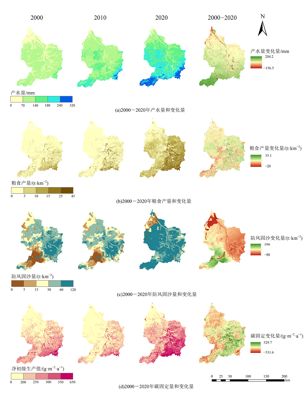
Figure 2 Spatial pattern of ecosystem services from 2000 to 2020
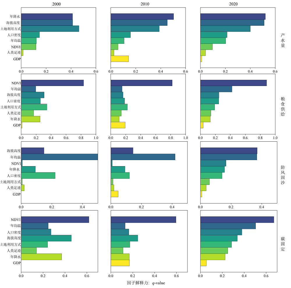
Figure 3 Results of influencing factors on ecosystem services in the tabu river basin from 2000 to 2020
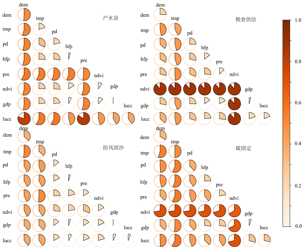
Figure 4 Interactive effects of influencing factors on ecosystem services in the tatu river basin in 2022
| 生态系统服务 | 影响因子 | 对应q值 | 交互因子 | 对应q值 | 交互影响 | 增长率/% |
|---|---|---|---|---|---|---|
| 产水 | 土地利用方式 | 0.4002 | 人口密度 | 0.2135 | 0.5771 | 44.2 |
| 土地利用方式 | 0.4002 | 海拔高度 | 0.5110 | 0.8008 | 56.7 | |
| 粮食供给 | 年均温 | 0.4216 | 年降水 | 0.1304 | 0.4901 | 16.3 |
| 年均温 | 0.4216 | 土地利用方式 | 0.1896 | 0.4667 | 10.7 | |
| 防风固沙 | 年均温 | 0.3677 | 年降水 | 0.1568 | 0.5113 | 39.1 |
| 年均温 | 0.3677 | 人口密度 | 0.1407 | 0.4533 | 23.3 | |
| 固碳 | 年均温 | 0.5041 | 年降水 | 0.2246 | 0.5655 | 12.2 |
| 年均温 | 0.5041 | 土地利用方式 | 0.2836 | 0.5747 | 14.0 |
Table 4 Results of dominant interaction detection of influencing factors on ecosystem services in the tatu river basin in 2020
| 生态系统服务 | 影响因子 | 对应q值 | 交互因子 | 对应q值 | 交互影响 | 增长率/% |
|---|---|---|---|---|---|---|
| 产水 | 土地利用方式 | 0.4002 | 人口密度 | 0.2135 | 0.5771 | 44.2 |
| 土地利用方式 | 0.4002 | 海拔高度 | 0.5110 | 0.8008 | 56.7 | |
| 粮食供给 | 年均温 | 0.4216 | 年降水 | 0.1304 | 0.4901 | 16.3 |
| 年均温 | 0.4216 | 土地利用方式 | 0.1896 | 0.4667 | 10.7 | |
| 防风固沙 | 年均温 | 0.3677 | 年降水 | 0.1568 | 0.5113 | 39.1 |
| 年均温 | 0.3677 | 人口密度 | 0.1407 | 0.4533 | 23.3 | |
| 固碳 | 年均温 | 0.5041 | 年降水 | 0.2246 | 0.5655 | 12.2 |
| 年均温 | 0.5041 | 土地利用方式 | 0.2836 | 0.5747 | 14.0 |
| [1] | CUI L H, SHEN Z, LIU Y X, et al., 2022. Identification of driving forces for windbreak and sand fixation services in semiarid and arid areas: A case of Inner Mongolia, China[J]. Progress in Physical Geography, 47(1): 32-49. |
| [2] | FANG L L, WANG L C, CHEN W X, et al., 2021. Identifying the impacts of natural and human factors on ecosystem service in the Yangtze and Yellow River Basins[J]. Journal of Cleaner Production, 314(1): 127995. |
| [3] | GU Q, WEI J, LUO S C, et al., 2018. Potential and environmental control of carbon sequestration in major ecosystems across arid and semi-arid regions in China[J]. Science of The Total Environment, 645(2): 796-805. |
| [4] | KANDZIORA M, BURKHARD B, MÜLLER F, 2013. Interactions of ecosystem properties, ecosystem integrity and ecosystem service indicators: A theoretical matrix exercise[J]. Ecological Indicators, 28(3): 54-78. |
| [5] |
LAL R, 2019. Carbon Cycling in Global Drylands[J]. Current Climate Change Reports, 5(3): 221-232.
DOI |
| [6] | LI B J, CHEN D X, WU S H, et al., 2016. Spatio-temporal assessment of urbanization impacts on ecosystem services: Case study of Nanjing City, China[J]. Ecological Indicators, 71(4): 416-427. |
| [7] | LI H N, DANG X H, HAN Y L, et al., 2023. Sand-fixing measures improve soil particle distribution and promote soil nutrient accumulation for desert - Yellow River coastal ecotone, China[J]. Ecological Indicators, 157(5): 111239. |
| [8] | LI Q, ZHANG X F, LIU Q F, et al., 2017. Impact of Land Use Intensity on Ecosystem Services: An example from the agro-pastoral ecotone of central Inner Mongolia[J]. Sustainability, 9(6): 1030. |
| [9] | LI Z H, XIA J, DENG X Z, et al., 2021. Multilevel modelling of impacts of human and natural factors on ecosystem services change in an oasis, Northwest China[J]. Resources Conservation and Recycling, 169(6): 105474. |
| [10] | LIU J J, XU Y, SHAN Y X, et al., 2021. Biotic and abiotic factors determine species diversity-productivity relationships in mountain meadows[J]. Journal of Plant Ecology, 14(6): 1175-1188. |
| [11] | NARAIN P, 2008. Dryland management in arid ecosystem[J]. Journal of the Indian Society of Soil Science, 56(4): 337-347. |
| [12] | SALEH A, FRYREAR D W, 1999. Soil roughness for the revised wind erosion equation (RWEQ)[J]. Journal of Soil and Water Conservation, 54(2): 473-476. |
| [13] | SINGH P K, CHUDASAMA H, 2021. Pathways for climate change adaptations in arid and semi-arid regions[J]. Journal of Cleaner Production, 7(7): 124744. |
| [14] | SONG S R, CHEN X, HU Z Y, et al., 2023. Deciphering the impact of wind erosion on ecosystem services: An integrated framework for assessment and spatiotemporal analysis in arid regions[J]. Ecological Indicators, 154(8): 110693. |
| [15] | WANG H, LIU G H, LI Z S, et al., 2020. Processes and driving forces for changing vegetation ecosystem services: Insights from the Shaanxi Province of China[J]. Ecological Indicators, 112(9): 106105. |
| [16] | WANG L J, GONG J W, MA S, et al., 2022. Ecosystem service supply- demand and socioecological drivers at different spatial scales in Zhejiang Province, China[J]. Ecological Indicators, 140(10): 109058. |
| [17] | XIANG S J, WANG Y, DENG H, et al., 2022. Response and multi-scenario prediction of carbon storage to land use/cover change in the main urban area of Chongqing, China[J]. Ecological Indicators, 142(11): 109205. |
| [18] | XUE C L, ZHANG H Q, WU S M, et al., 2022. Spatial-temporal evolution of ecosystem services and its potential drivers: A geospatial perspective from Bairin Left Banner, China[J]. Ecological Indicators, 137(12): 108760. |
| [19] | YANG Y, TILMAN D, FUREY G, et al., 2019. Soil carbon sequestration accelerated by restoration of grassland biodiversity[J]. Nature Communications, 10(1): 1-7. |
| [20] | YU Y, HUA T, CHEN L D, et al., 2023. Divergent changes in vegetation greenness, productivity, and rainfall use efficiency are characteristic of ecological restoration towards high-quality development in the Yellow River Basin, China[J]. Engineering, 13(13): 109-119. |
| [21] |
YU Y, PI Y Y, YU X, et al., 2019. Climate change, water resources and sustainable development in the arid and semi-arid lands of Central Asia in the past 30 years[J]. Journal of Arid Land, 11(1): 1-14.
DOI |
| [22] |
曹云, 孙应龙, 姜月清, 等, 2022. 黄河流域净生态系统生产力的时空分异特征及其驱动因子分析[J]. 生态环境学报, 31(11): 2101-2110.
DOI |
| CAO Y, SUN Y L, JIANG Y Q, et al., 2022. Analysis on temporal-spatial variations and driving factors of net ecosystem productivity in the Yellow River Basin[J]. Ecology and Environment, 31(11): 2101-2110. | |
| [23] | 陈海霞, 黄宗胜, 赵明伟, 等, 2020. 喀斯特地区4种草本植物及其基质的优先选择[J]. 土壤学报, 57(4): 1017-1031. |
| CHEN H X, HUANG Z S, ZHAO M W, et al., 2020. Four species of herbs in karst areas and their adaptabilities to the karst matrices[J]. Acta Pedologica Sinica, 57(4): 1017-1031. | |
| [24] |
陈云, 李玉强, 王旭洋, 等, 2022. 中国生态脆弱区全球变化风险及应对技术途径和主要措施[J]. 中国沙漠, 42(3): 148-158.
DOI |
|
CHEN Y, LI Y Q, WANG X Y, et al., 2022. Risk and countermeasures of global change in ecologically vulnerable regions of China[J]. Journal of Desert Research, 42(3): 148-158.
DOI |
|
| [25] |
傅伯杰, 于丹丹, 2016. 生态系统服务权衡与集成方法[J]. 资源科学, 38(1): 1-9.
DOI |
|
FU B J, YU D D, 2016. Trade-off analyses and synthetic integrated method of multiple ecosystem services[J]. Resources Science, 38(1): 1-9.
DOI |
|
| [26] |
刘璐璐, 曹巍, 吴丹, 等, 2018. 国家重点生态功能区生态系统服务时空格局及其变化特征[J]. 地理科学, 38(9): 1508-1515.
DOI |
|
LIU L L, CAO W, WU D, et al., 2018. Temporal and spatial variations of ecosystem services in national key ecological function zones[J]. Scientia Geographica Sinica, 38(9): 1508-1515.
DOI |
|
| [27] | 刘利民, 王婷婷, 李秀芬, 等, 2021. 近15年内蒙古防沙带防风固沙功能时空变化特征[J]. 生态学杂志, 40(11): 3436-3447. |
|
LIU L M, WANG T T, LI X F, et al., 2021. Spatiotemporal variations of wind prevention and sand fixation function in the sand-prevention belt in Inner Mongolia in recent 15 years[J]. Chinese Journal of Ecology, 40(11): 3436-3447.
DOI |
|
| [28] |
欧定华, 夏建国, 张莉, 等, 2015. 区域生态安全格局规划研究进展及规划技术流程探讨[J]. 生态环境学报, 24(1): 163-173.
DOI |
| OU D H, XIA J G, ZHANG L, et al., 2015. Research progress on regional ecological security pattern planning and discussion of planning techniqueflow[J]. Ecology and Environmental Sciences, 24(1): 163-173. | |
| [29] |
潘换换, 吴树荣, 姬倩倩, 等, 2021. 山西煤田生态系统服务时空格局及驱动力[J]. 应用生态学报, 32(11): 3923-3932.
DOI |
| PAN H H, WU S R, JI Q Q, et al., 2021. Spatio-temporal pattern and driving forces of ecosystem services in coalfields of Shanxi Province, China[J]. Chinese Journal of Applied Ecology, 32(11): 3923-3932. | |
| [30] | 孙贺阳, 2018. 基于SWAT模型塔布河流域水文模拟与预测[D]. 呼和浩特: 内蒙古大学. |
| SUN H Y, 2018. Hydrologic simulation and prediction basedon the swat model[D]. Hohhot: Inner Mongolia university. | |
| [31] | 田美荣, 高吉喜, 宋国宝, 等, 2017. 基于主导生态功能与生态退化程度的生态修复分区研究[J]. 生态与农村环境学报, 33(1): 7-14. |
| TIAN M R, GAO J X, SONG G B, et al., 2017. Zoning for ecological remediation by dominant ecological function and ecological degradation degree[J]. Journal of Ecology and Rural Environment, 33(1): 7-14. | |
| [32] |
王劲峰, 徐成东, 2017. 地理探测器: 原理与展望[J]. 地理学报, 72(1):116-134.
DOI |
| WANG J F, XU C D, 2017. Geodetector: Principle and prospective[J]. Actc Geographica Sinica, 72(1): 116-134. | |
| [33] |
王琳, 卫伟, 2023. 黄土高原典型县域生态系统服务变化特征及驱动因素[J]. 生态环境学报, 32(6): 1140-1148.
DOI |
| WANG L, WEI W, 2023. Characteristics and driving factors of ecosystem services changes in a typical county of the Loess Plateau[J]. Ecology and Environmental Sciences, 32(6): 1140-1148. | |
| [34] |
王晓峰, 符鑫鑫, 楚冰洋, 等, 2021. 秦岭生态屏障产水服务时空演变特征及驱动要素[J]. 自然资源学报, 36(10): 2507-2521.
DOI |
| WANG X F, FU X X, CHU B Y, et al., 2021. Spatio-temporal variation of water yield and its driving factors in Qinling Mountains barrier region[J]. Journal of Natural Resources, 36(10): 2507-2521. | |
| [35] | 王彦阁, 2020. 内蒙古阴山北麓农牧交错区土地利用动态分析及预测[J]. 浙江林业科技, 40(4): 10-17. |
| WANG Y G, 2020. Analysis and Prediction of Land Use Types in Agro-Pastoral Ecotone in the Northern Yinshan Mountain of Inner Mongolia[J]. Journal of Zhejiang Forestry Science and Technology, 40(4): 10-17. | |
| [36] | 王一, 郝利娜, 许强, 等, 2023. 2001-2019年黄土高原植被覆盖度时空演化特征及地理因子解析[J]. 生态学报, 43(6): 2397-2407. |
| WANG Y, HAO L N, XU Q, et al., 2023. Spatio-temporal variations of vegetation coverage and its geographical factors analysis on the Loess Plateau from 2001 to 2019[J]. Acta Ecologica Sinica, 43(6): 2397-2407. | |
| [37] | 徐勇, 卢云贵, 戴强玉, 等, 2023. 气候变化和土地利用变化对长江中下游地区植被NPP变化相对贡献分析[J]. 中国环境科学, 43(9): 4988-5000. |
| XU Y, LU Y G, DAI Q Y, et al., 2023. Assessment of the relative contribution of climate change and land use change on net primary productivity variation in the middle and lower reaches of the Yangtze River Basin[J]. China Environmental Science, 43(9): 4988-5000. | |
| [38] | 张彪, 王爽, 2020. 锡林郭勒盟风沙源治理区防风固沙功能变化评估[J]. 生态与农村环境学报, 36(3): 291-299. |
| ZHANG B, WANG S, 2020. Dynamic changes of the sand-fixing service in the sandstorm source control region of Xilingol League[J]. Journal of Ecology and Rural Environment, 36(3): 291-299. | |
| [39] | 张浩斌, 王婉, 宋妤婧, 等, 2024. 基于改进遥感生态指数的干旱内流区生态质量评价——以阴山北麓塔布河流域为例[J]. 生态学报, 44(2): 523-543. |
| ZHANG H B, WANG W, SONG Y J, et al., 2024. Ecological index evaluation of arid inflow area based on the modified remote sensing ecological index: A case study of Tabu River Basin at the northern foot of Yin Mountains[J]. Acta Ecologica Sinica, 44(2): 523-543. | |
| [40] | 赵恒谦, 刘轩绮, 刘哿, 等, 2024. 京津风沙源区NPP时空变化及其对治理工程实施的响应[J]. 生态学报, 44(6): 2406-2419. |
| ZHAO H Q, LIU X Q, LIU G, et al., 2024. Spatio-temporal variation of net primary productivity in the Beijing-tianjin sandstorm source area and its response to the implementation of control projects[J]. Acta Ecologica Sinica, 44(6): 2406-2419. | |
| [41] |
张静静, 朱文博, 朱连奇, 等, 2020. 伏牛山地区森林生态系统服务权衡/协同效应多尺度分析[J]. 地理学报, 75(5): 975-988.
DOI |
| ZHANG J J, ZHU W B, ZHU L Q, et al., 2020. Multi-scale analysis of trade-off/synergy effects of forest ecosystem services in the Funiu Mountain Region[J]. Actc Geographica Sinica, 75(5): 975-988. | |
| [42] | 赵文亮, 贺振, 贺俊平, 等, 2012. 基于MODIS-NDVI的河南省冬小麦产量遥感估测[J]. 地理研究, 31(12): 2310-2320. |
| ZHAO W L, HE Z, HE J P, et al., 2012. Remote sensing estimation for winter wheat yield in Henan based on the MODIS-NDVI data[J]. Geographical Research, 31(12): 2310-2320. | |
| [43] | 朱文泉, 2005. 基于GIS和RS的区域陆地植被NPP估算——以中国内蒙古为例[J]. 遥感学报, 5(3): 300-307. |
| ZHU W Q, 2005. Estimating net primary productivity of terrestrial vegetation based on GIS and RS: A Case Study in Inner Mongolia, China[J]. National Remote Sensing Bulletin, 5(3): 300-307. | |
| [44] | 张鑫建, 龙胤慧, 廖梓龙, 等, 2023. 阴山北麓塔布河流域产水量时空变化规律研究[J]. 节水灌溉, 23(10): 98-107. |
| ZHANG X J, LONG Y H, LIAO Z L, et al., 2023. Temporal and spatial variation of water yield in the tabu river basin of the northern Yinshan Mountain[J]. Water Saving Irrigation, 23(10): 98-107. |
| Viewed | ||||||
|
Full text |
|
|||||
|
Abstract |
|
|||||
Copyright © 2021 Editorial Office of ACTA PETROLEI SINICA
Address:No. 6 Liupukang Street, Xicheng District, Beijing, P.R.China, 510650
Tel: 86-010-62067128, 86-010-62067137, 86-010-62067139
Fax: 86-10-62067130
Email: syxb@cnpc.com.cn
Support byBeijing Magtech Co.ltd, E-mail:support@magtech.com.cn