Ecology and Environmental Sciences ›› 2026, Vol. 35 ›› Issue (6): 948-962.DOI: 10.16258/j.cnki.1674-5906.2026.06.012
• Research Article [Environmental Science] • Previous Articles Next Articles
TIAN Yunxin1,2( ), WANG Jiao1,2,*(), JIA Xiaoxu1,2, MA Changkun3, SHAO Ming’an1,2
Received:2025-11-26
Revised:2026-03-30
Accepted:2026-04-27
Online:2026-06-18
Published:2026-06-08
田昀鑫1,2(), 王娇1,2,*(), 贾小旭1,2, 马昌坤3, 邵明安1,2
通讯作者:
* 王娇,E-mail: 作者简介:田昀鑫(2002年生),女,硕士研究生,主要研究方向为旱区生态水文。E-mail: tianyunxin24@mails.ucas.ac.cn
基金资助:CLC Number:
TIAN Yunxin, WANG Jiao, JIA Xiaoxu, MA Changkun, SHAO Ming’an. Characteristics of Surface Water Nutrients and Their Response to Land Use in the Economic Belt on the Northern Slope of the Tianshan Mountains[J]. Ecology and Environmental Sciences, 2026, 35(6): 948-962.
田昀鑫, 王娇, 贾小旭, 马昌坤, 邵明安. 天山北坡经济带地表水营养盐特征及其对土地利用的响应[J]. 生态环境学报, 2026, 35(6): 948-962.
Add to citation manager EndNote|Ris|BibTeX
URL: https://www.jeesci.com/EN/10.16258/j.cnki.1674-5906.2026.06.012

Figure 1 Schematic diagram of research zoning and sampling locations
| 营养盐指标 | Ⅰ类 | Ⅱ类 | Ⅲ类 | Ⅳ类 | Ⅴ类 |
|---|---|---|---|---|---|
| NH3-N | 0.15 | 0.5 | 1.0 | 1.5 | 2.0 |
| TN | 0.2 | 0.5 | 1.0 | 1.5 | 2.0 |
| TP | 0.02(湖、库0.01) | 0.1(湖、库0.025) | 0.2(湖、库0.05) | 0.3(湖、库0.1) | 0.4(湖、库0.2) |
| CODCr | 15 | 15 | 20 | 30 | 40 |
| BOD5 | 3 | 3 | 4 | 6 | 10 |
Table 1 Standard limits for basic surface water quality parameters mg·L?1
| 营养盐指标 | Ⅰ类 | Ⅱ类 | Ⅲ类 | Ⅳ类 | Ⅴ类 |
|---|---|---|---|---|---|
| NH3-N | 0.15 | 0.5 | 1.0 | 1.5 | 2.0 |
| TN | 0.2 | 0.5 | 1.0 | 1.5 | 2.0 |
| TP | 0.02(湖、库0.01) | 0.1(湖、库0.025) | 0.2(湖、库0.05) | 0.3(湖、库0.1) | 0.4(湖、库0.2) |
| CODCr | 15 | 15 | 20 | 30 | 40 |
| BOD5 | 3 | 3 | 4 | 6 | 10 |
| 营养盐指标 | 水体类型 | 样本数 | 最大质量浓度/ (mg·L−1) | 最小质量浓度/ (mg·L−1) | 5%剪除后均值/ (mg·L−1) | 标准差 | 变异系数 | 超过Ⅲ类比例/ % | 单因子污染指数(Pi) | |
|---|---|---|---|---|---|---|---|---|---|---|
| 变化范围 | 平均值 | |||||||||
| NO3−-N | 河流 | 109 | 7.46 | 0.14 | 1.14 | 1.32 | 0.86 | 39.45 | 0.01-7.46 | 1.26 |
| 湖泊 | 16 | 2.55 | 0.08 | 0.66 | 0.67 | 0.99 | 18.75 | 0.08-2.55 | 0.73 | |
| 水库 | 60 | 4.46 | 0.06 | 0.95 | 0.73 | 1.29 | 25.00 | 0.01-2.76 | 0.82 | |
| NH3-N | 河流 | 109 | 0.77 | 0.01 | 0.17 | 0.12 | 1.45 | 0.00 | 0.04-2.28 | 0.27 |
| 湖泊 | 16 | 0.64 | 0.08 | 0.33 | 0.21 | 1.60 | 0.00 | 0.05-0.62 | 0.28 | |
| 水库 | 60 | 1.33 | 0.01 | 0.30 | 0.31 | 0.95 | 3.33 | 0.04-4.46 | 0.47 | |
| NO2−-N | 河流 | 109 | 1.88 | <ρ(LOD) | <ρ(LOD) | 0.62 | 0.00 | - | - | - |
| 湖泊 | 16 | 0.47 | <ρ(LOD) | 0.01 | 0.39 | 0.07 | - | - | - | |
| 水库 | 60 | 0.38 | <ρ(LOD) | 0.01 | 0.32 | 0.12 | - | - | - | |
| TN | 河流 | 109 | 8.16 | <ρ(LOD) | 0.94 | 1.52 | 0.62 | 35.78 | 0.02-8.16 | 1.18 |
| 湖泊 | 16 | 1.75 | 0.11 | 0.90 | 0.52 | 1.73 | 56.25 | 0.11-1.75 | 0.90 | |
| 水库 | 60 | 3.75 | <ρ(LOD) | 0.72 | 0.74 | 0.98 | 30.00 | 0.00-3.75 | 0.80 | |
| TP | 河流 | 109 | 3.79 | <ρ(LOD) | 0.02 | 0.40 | 0.04 | 6.42 | 0.00-18.93 | 0.42 |
| 湖泊 | 16 | 0.09 | <ρ(LOD) | 0.02 | 0.03 | 0.68 | 12.50 | 0.00-1.80 | 0.50 | |
| 水库 | 60 | 0.71 | <ρ(LOD) | 0.02 | 0.12 | 0.15 | 11.67 | 0.00-14.20 | 0.78 | |
| CODCr | 河流 | 109 | 57.38 | <ρ(LOD) | 5.87 | 11.32 | 0.52 | 9.17 | 0.00-2.87 | 0.40 |
| 湖泊 | 16 | 144.86 | <ρ(LOD) | 30.47 | 37.60 | 0.81 | 43.75 | 0.00-7.24 | 1.73 | |
| 水库 | 60 | 64.95 | <ρ(LOD) | 13.71 | 18.72 | 0.73 | 18.33 | 0.00-3.25 | 0.77 | |
| BOD5 | 河流 | 68 | 15.00 | <ρ(LOD) | 1.48 | 2.65 | 0.56 | 8.82 | 0.00-1.68 | 0.34 |
| 湖泊 | 15 | 18.20 | <ρ(LOD) | 2.21 | 4.56 | 0.48 | 46.67 | 0.00-4.55 | 1.64 | |
| 水库 | 28 | 15.83 | <ρ(LOD) | 1.96 | 3.98 | 0.49 | 17.86 | 0.00-1.60 | 0.44 | |
Table 2 Statistical results of nutrients in typical surface water in the economic belt on the northern slope of the Tianshan Mountains
| 营养盐指标 | 水体类型 | 样本数 | 最大质量浓度/ (mg·L−1) | 最小质量浓度/ (mg·L−1) | 5%剪除后均值/ (mg·L−1) | 标准差 | 变异系数 | 超过Ⅲ类比例/ % | 单因子污染指数(Pi) | |
|---|---|---|---|---|---|---|---|---|---|---|
| 变化范围 | 平均值 | |||||||||
| NO3−-N | 河流 | 109 | 7.46 | 0.14 | 1.14 | 1.32 | 0.86 | 39.45 | 0.01-7.46 | 1.26 |
| 湖泊 | 16 | 2.55 | 0.08 | 0.66 | 0.67 | 0.99 | 18.75 | 0.08-2.55 | 0.73 | |
| 水库 | 60 | 4.46 | 0.06 | 0.95 | 0.73 | 1.29 | 25.00 | 0.01-2.76 | 0.82 | |
| NH3-N | 河流 | 109 | 0.77 | 0.01 | 0.17 | 0.12 | 1.45 | 0.00 | 0.04-2.28 | 0.27 |
| 湖泊 | 16 | 0.64 | 0.08 | 0.33 | 0.21 | 1.60 | 0.00 | 0.05-0.62 | 0.28 | |
| 水库 | 60 | 1.33 | 0.01 | 0.30 | 0.31 | 0.95 | 3.33 | 0.04-4.46 | 0.47 | |
| NO2−-N | 河流 | 109 | 1.88 | <ρ(LOD) | <ρ(LOD) | 0.62 | 0.00 | - | - | - |
| 湖泊 | 16 | 0.47 | <ρ(LOD) | 0.01 | 0.39 | 0.07 | - | - | - | |
| 水库 | 60 | 0.38 | <ρ(LOD) | 0.01 | 0.32 | 0.12 | - | - | - | |
| TN | 河流 | 109 | 8.16 | <ρ(LOD) | 0.94 | 1.52 | 0.62 | 35.78 | 0.02-8.16 | 1.18 |
| 湖泊 | 16 | 1.75 | 0.11 | 0.90 | 0.52 | 1.73 | 56.25 | 0.11-1.75 | 0.90 | |
| 水库 | 60 | 3.75 | <ρ(LOD) | 0.72 | 0.74 | 0.98 | 30.00 | 0.00-3.75 | 0.80 | |
| TP | 河流 | 109 | 3.79 | <ρ(LOD) | 0.02 | 0.40 | 0.04 | 6.42 | 0.00-18.93 | 0.42 |
| 湖泊 | 16 | 0.09 | <ρ(LOD) | 0.02 | 0.03 | 0.68 | 12.50 | 0.00-1.80 | 0.50 | |
| 水库 | 60 | 0.71 | <ρ(LOD) | 0.02 | 0.12 | 0.15 | 11.67 | 0.00-14.20 | 0.78 | |
| CODCr | 河流 | 109 | 57.38 | <ρ(LOD) | 5.87 | 11.32 | 0.52 | 9.17 | 0.00-2.87 | 0.40 |
| 湖泊 | 16 | 144.86 | <ρ(LOD) | 30.47 | 37.60 | 0.81 | 43.75 | 0.00-7.24 | 1.73 | |
| 水库 | 60 | 64.95 | <ρ(LOD) | 13.71 | 18.72 | 0.73 | 18.33 | 0.00-3.25 | 0.77 | |
| BOD5 | 河流 | 68 | 15.00 | <ρ(LOD) | 1.48 | 2.65 | 0.56 | 8.82 | 0.00-1.68 | 0.34 |
| 湖泊 | 15 | 18.20 | <ρ(LOD) | 2.21 | 4.56 | 0.48 | 46.67 | 0.00-4.55 | 1.64 | |
| 水库 | 28 | 15.83 | <ρ(LOD) | 1.96 | 3.98 | 0.49 | 17.86 | 0.00-1.60 | 0.44 | |
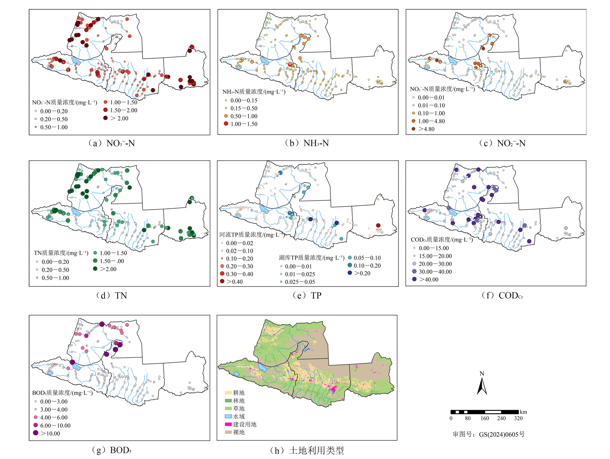
Figure 2 Spatial distribution of nutrients in the economic belt on the northern slope of the Tianshan Mountains
| 营养盐指标 | 不同分区地表水营养盐均值 | |||
|---|---|---|---|---|
| 西北区 | 西区 | 中区 | 东区 | |
| NO3⁻-N | 1.34 | 0.84 | 0.90 | 1.97 |
| NH3-N | 0.14 | 0.23 | 0.24 | 0.11 |
| NO2⁻-N | <ρ(LOD) | 0.025 | <ρ(LOD) | 0.003 |
| TN | 1.62 | 0.62 | 0.52 | 1.61 |
| TP | 0.03 | 0.01 | 0.01 | <ρ(LOD) |
| CODCr | 10.09 | 10.01 | 11.83 | 2.08 |
| BOD5 | 2.31 | 0.80 | 4.29 | - |
Table 3 Mean values of nutrients in surface water from different subregions in the economic belt on the northern slope of the Tianshan Mountains mg·L?1
| 营养盐指标 | 不同分区地表水营养盐均值 | |||
|---|---|---|---|---|
| 西北区 | 西区 | 中区 | 东区 | |
| NO3⁻-N | 1.34 | 0.84 | 0.90 | 1.97 |
| NH3-N | 0.14 | 0.23 | 0.24 | 0.11 |
| NO2⁻-N | <ρ(LOD) | 0.025 | <ρ(LOD) | 0.003 |
| TN | 1.62 | 0.62 | 0.52 | 1.61 |
| TP | 0.03 | 0.01 | 0.01 | <ρ(LOD) |
| CODCr | 10.09 | 10.01 | 11.83 | 2.08 |
| BOD5 | 2.31 | 0.80 | 4.29 | - |
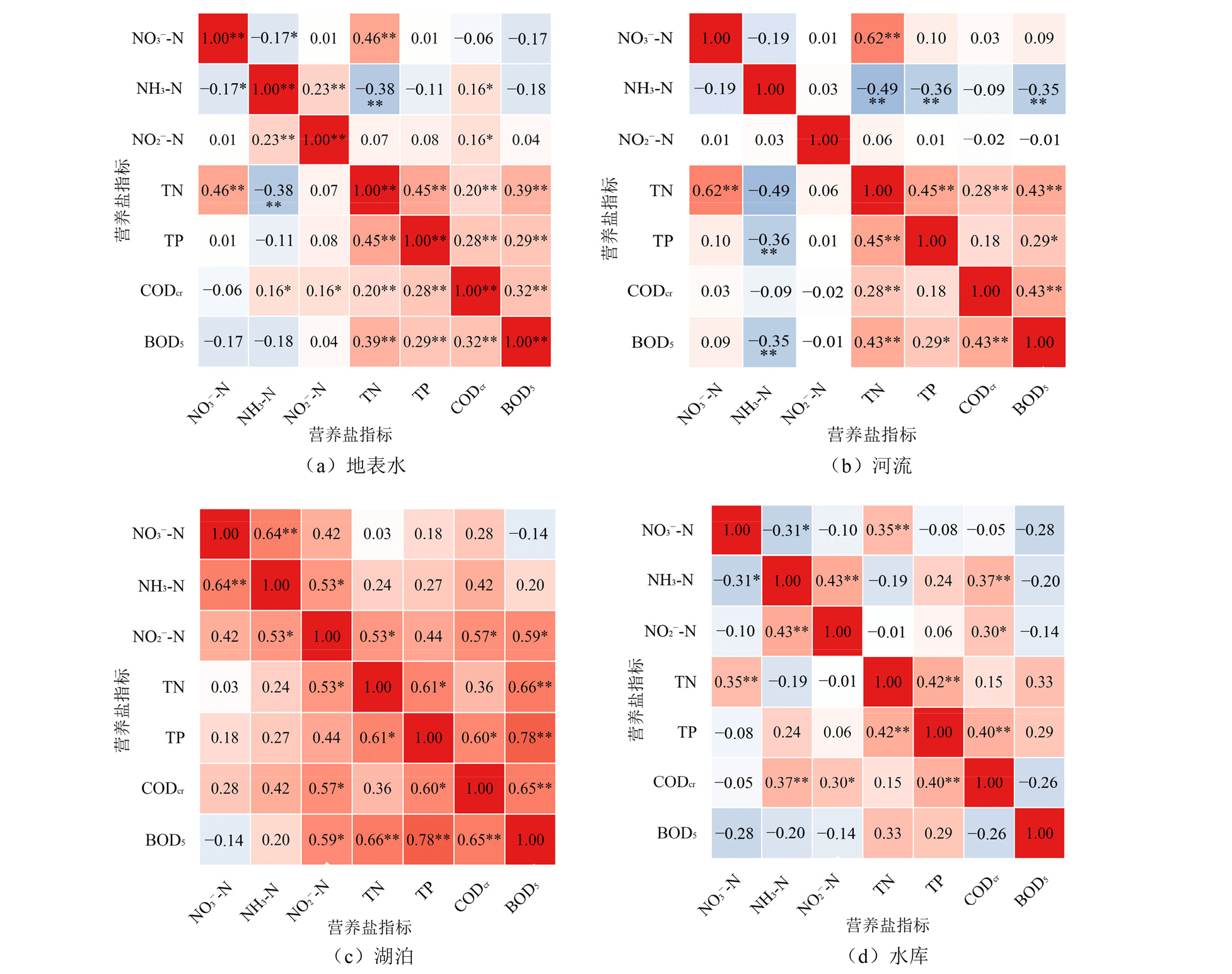
Figure 3 Correlation analysis of nutrients in surface water in the economic belt on the northern slope of the Tianshan Mountains
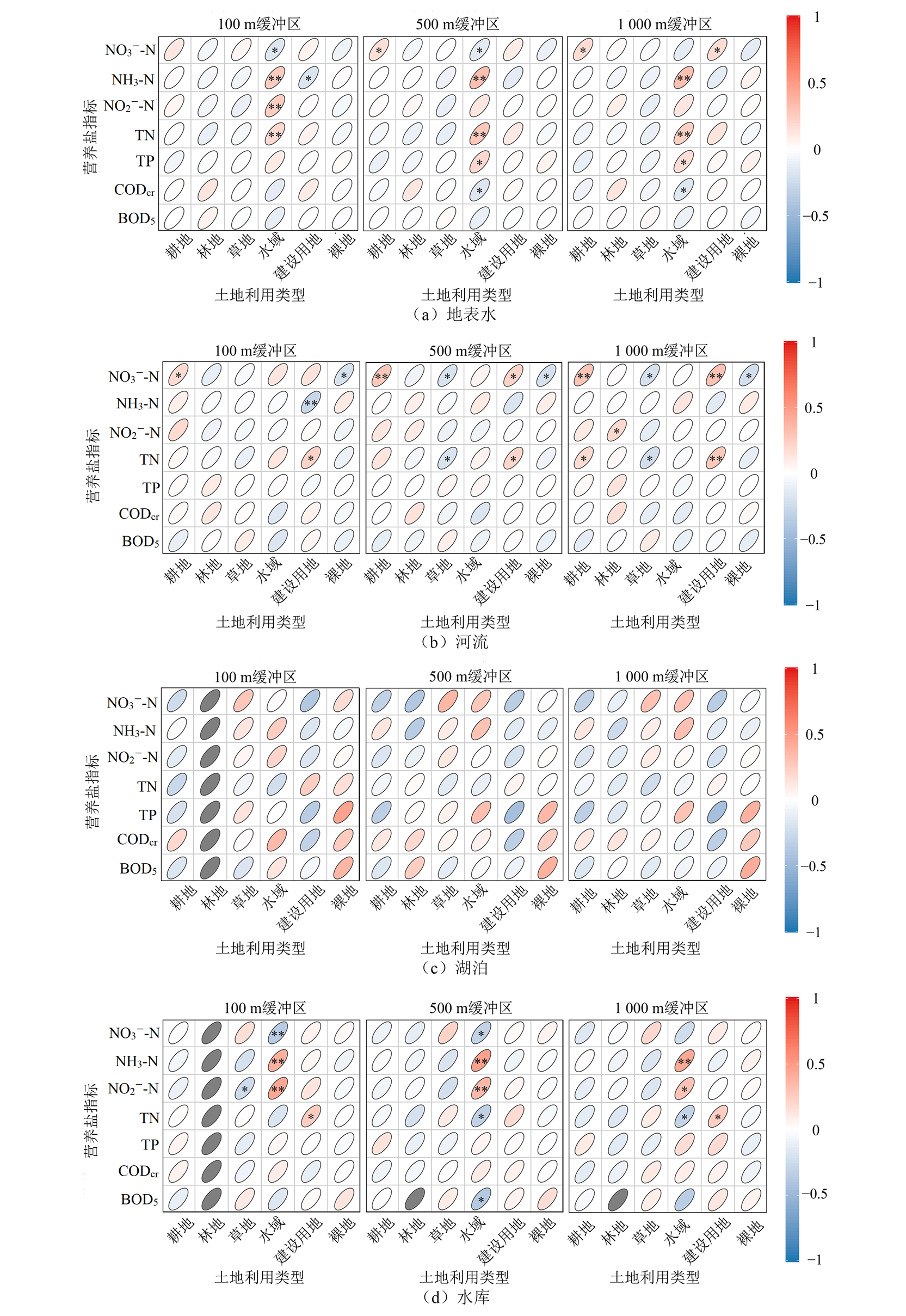
Figure 4 Correlation analysis between water nutrients and land use type at different buffer zone scales
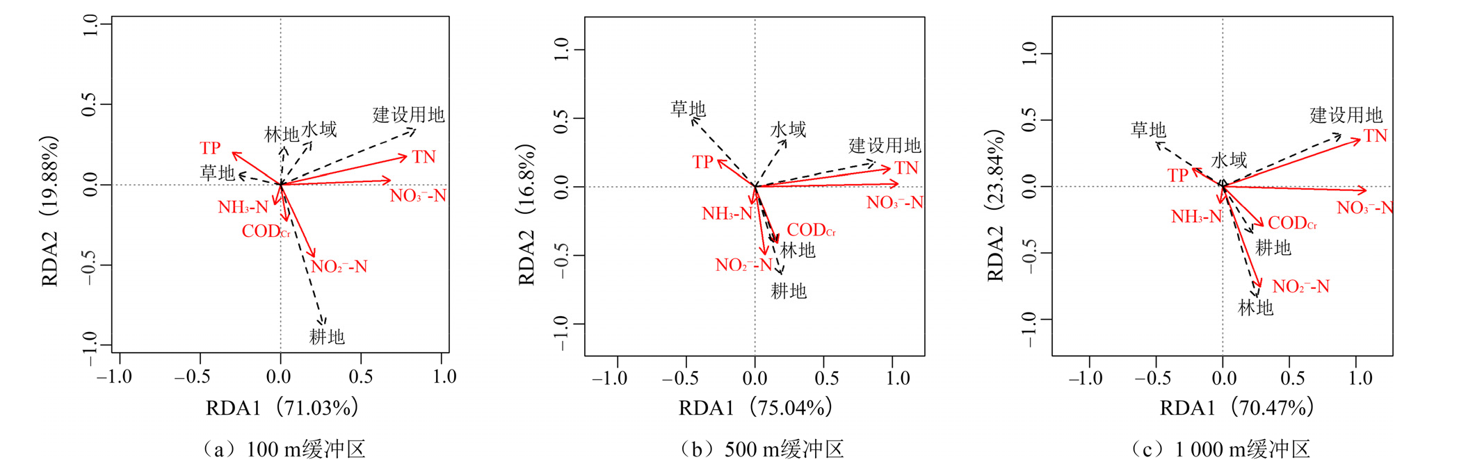
Figure 5 Ranking of nutrient indicators in river water and land use type for redundancy analysis
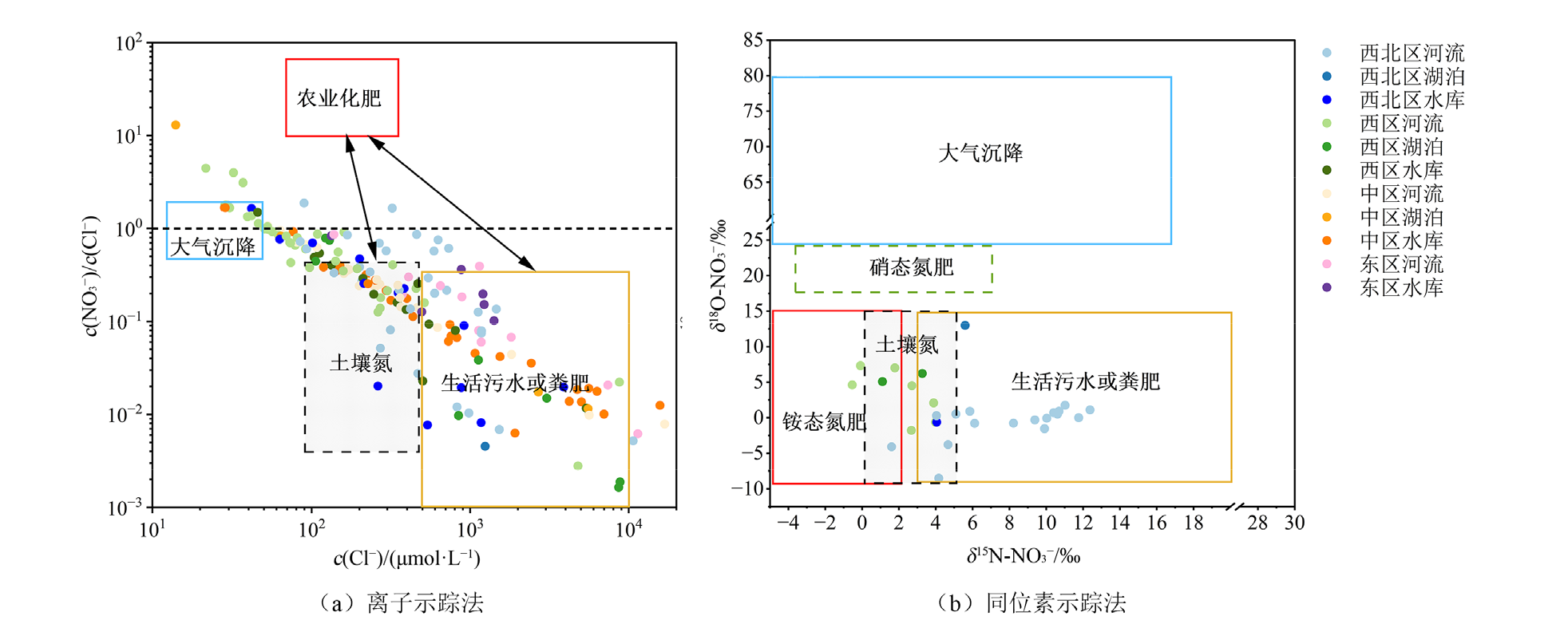
Figure 6 Analysis of nitrate sources in surface water in the economic belt on the northern slope of the Tianshan Mountains
| [1] |
AHEARN D S, SHEIBLEY R W, DAHLGREN R A, et al., 2005. Land use and land cover influence on water quality in the last free-flowing river draining the western Sierra Nevada, California[J]. Journal of Hydrology, 313(3): 234-247.
DOI URL |
| [2] |
TORRES-MARTÍNEZ J A, MORA A, MAHLKNECHT J, et al., 2021. Estimation of nitrate pollution sources and transformations in groundwater of an intensive livestock-agricultural area (Comarca Lagunera), combining major ions, stable isotopes and MixSIAR model[J]. Environmental Pollution, 269: 115445.
DOI URL |
| [3] |
GIRI S, QIU Z, 2016. Understanding the relationship of land uses and water quality in twenty first century: A review[J]. Journal of Environmental Management, 173: 41-48.
DOI PMID |
| [4] |
HAN L, HUANG M S, MA M H, et al., 2018. Evaluating sources and processing of nonpoint source nitrate in a small suburban watershed in China[J]. Journal of Hydrology, 559: 661-668.
DOI URL |
| [5] |
HE S, LI P Y, SU F M, et al., 2022. Identification and apportionment of shallow groundwater nitrate pollution in Weining Plain, northwest China, using hydrochemical indices, nitrate stable isotopes, and the new bayesian stable isotope mixing model (MixSIAR)[J]. Environmental Pollution, 298: 118852.
DOI URL |
| [6] |
HEATON T H E, 1986. Isotopic studies of nitrogen pollution in the hydrosphere and atmosphere: A review[J]. Chemical Geology: Isotope Geoscience Section, 59: 87-102.
DOI URL |
| [7] | LI X F, SARDANS J, QI M T, et al., 2022. Nitrous oxide concentration and flux in Min River Basin of southeast China: Effects of land use, stream order and water variables[J]. Journal of Hydrology, 614A: 128507. |
| [8] |
LI X, XU Y J, NI M, et al., 2023. Riverine nitrate source and transformation as affected by land use and land cover[J]. Environmental Research, 222: 115380.
DOI URL |
| [9] |
LUNA J, MASINO P, BERTONE E, et al., 2023. Towards nutrient neutrality: A review of agricultural runoff mitigation strategies and the development of a decision-making framework[J]. Science of The Total Environment, 874: 162408.
DOI URL |
| [10] |
SORANNO P A, CHERUVELIL K S, WAGNER T, et al., 2015. Effects of land use on lake nutrients: The importance of scale, hydrologic connectivity, and region[J]. PLOS ONE, 10(8): e0135454.
DOI URL |
| [11] |
TROMBONI F, DODDS W K, 2017. Relationships between land use and stream nutrient concentrations in a highly urbanized tropical region of Brazil: Thresholds and riparian zones[J]. Environmental Management, 60(1): 30-40.
DOI PMID |
| [12] | XING G X, CAO Y C, SHI S L, et al., 2001. N pollution sources and denitrification in waterbodies in Taihu Lake region[J]. Science in China Series B: Chemistry, 44(3): 304-314. |
| [13] |
XUE D, BOTTE J, DE BAETS B, et al., 2009. Present limitations and future prospects of stable isotope methods for nitrate source identification in surface- and groundwater[J]. Water Research, 43(5): 1159-1170.
DOI PMID |
| [14] |
YAO X L, DING R N, ZHOU Y Q, et al., 2023. How internal nutrient loading forms in shallow lakes: Insights from benthic organic matter mineralization[J]. Water Research, 245: 120544.
DOI URL |
| [15] |
YAO J Q, CHEN Y N, GUAN X F, et al., 2022. Recent climate and hydrological changes in a mountain-basin system in Xinjiang, China[J]. Earth-Science Reviews, 226: 103957.
DOI URL |
| [16] |
YI Q T, ZHANG Y, XIE K, et al., 2020. Tracking nitrogen pollution sources in plain watersheds by combining high-frequency water quality monitoring with tracing dual nitrate isotopes[J]. Journal of Hydrology, 581: 124439.
DOI URL |
| [17] |
ZHANG C, RAO W B, WU Z H, et al., 2024. Anthropogenic impacts and quantitative sources of nitrate in a rural-urban canal using a combined PMF, δ15N/δ18O-NO3-, and MixSIAR approach[J]. Environmental Research, 251: 118587.
DOI URL |
| [18] |
ZHU B Q, YU J J, QIN X G, et al., 2013. The significance of mid-latitude rivers for weathering rates and chemical fluxes: Evidence from northern Xinjiang rivers[J]. Journal of Hydrology, 486: 151-174.
DOI URL |
| [19] | 柏鹏飞, 2025. 克拉玛依市土地利用变化及其生态效应研究[D]. 新疆: 新疆农业大学. |
| BAI P F, 2025. Study on land use change and its ecological effect in Karamay City[D]. Xinjiang: Xinjiang Agricultural University. | |
| [20] | 蔡宏, 何政伟, 安艳玲, 等, 2015. 基于遥感和GIS的赤水河水质对流域土地利用的响应研究[J]. 长江流域资源与环境, 24(2): 286-291. |
| CAI H, HE Z W, AN Y L, et al., 2015. Response relationship between land use and water quality in Chishui resources and environment in the Yangtze Basin[J]. Resources and Environment in the Yangtze Basin, 24(2): 286-291. | |
| [21] | 程同福, 2016. 新疆玛纳斯河水质现状评价及保护对策[J]. 水利规划与设计 (1): 29-32, 59. |
| CHENG T F, 2016. Evaluation of the current water quality status and protection strategies for the Manas River in Xinjiang[J]. Water Resources Planning and Design (1): 29-32, 59. | |
| [22] | 陈懿婧, 杨凤芸, 杨克, 2025. 1990-2020年天山北坡土地利用变化及驱动因素分析[J]. 辽宁科技大学学报, 48(1): 72-80. |
| CHEN Y J, YANG F Y, YANG K, 2025. Analysis of land use and driving factors on northern slope of Tianshan Mountains from 1990 to 2020[J]. Journal of University of Science and Technology Liaoning, 48(1): 72-80. | |
| [23] | 陈昱, 刘方平, 吴彩云, 等, 2023. 鄱阳湖流域典型种植模式农田地表径流与氮磷流失特征[J]. 灌溉排水学报, 42(7): 101-108. |
| CHEN Y, LIU F P, WU C Y, et al., 2023. Impact of planting practices on nitrogen and phosphorus loss via surface runoff in Poyang Lake Basin[J]. Journal of Irrigation and Drainage, 42(7): 101-108. | |
| [24] | 方创琳, 高倩, 张小雷, 等, 2019. 城市群扩展的时空演化特征及对生态环境的影响——以天山北坡城市群为例[J]. 中国科学: 地球科学, 49(9): 1413-1424. |
| FANG C L, GAO Q, ZHANG X L, et al., 2019. Spatiotemporal characteristics of the expansion of an urban agglomeration and its effect on the ecoenvironment: Case study on the northern slope of the Tianshan Mountains[J]. Science China Earth Sciences, 49(9): 1413-1424. | |
| [25] | 国家环境保护局, 1989. 水质总磷的测定钼酸铵分光光度法:GB11893-89[S]. 北京: 北京环保监测中心. |
| State Environmental Protection Administration, 1989. Water quality—Determination of total phosphorus-ammonium molybdate spectrophotometric method: GB 11893-89[S]. Beijing: Beijing Environmental Monitoring Center. | |
| [26] | 国家环境保护总局, 国家质量监督检验检疫总局, 2002. 地表水环境质量标准: GB 3838—2002[S]. 北京: 中国环境科学出版社. |
| State Environmental Protection Administration, General Administration of Quality Supervision, General Administration of Quality Supervision, Inspection and Quarantine of the People’s Republic of China, 2002. Environmental quality standards for surface water: GB 3838—2002[S]. Beijing: China Environmental Science Press. | |
| [27] | 韩芹芹, 宋富延, 陈建峰, 等, 2022. 2018-2021年乌鲁木齐市水磨河 (古牧地河、老龙河) 截污治污及水质状况变化趋势分析[J]. 环境科学导刊, 41(6): 57-64. |
| HAN Q Q, SONG F Y, CHEN J F, et al., 2022. Analysis of the trends in pollution interception, treatment, and water quality changes of the Shuimo River (Gumudi River, Laolong River) in Urumqi from 2018 to 2021[J]. Environmental Science Survey, 41(6): 57-64. | |
| [28] | 环境保护部, 2009. 水质五日生化需氧量(BOD5)的测定稀释与接种法:HJ505—2009[S]. 北京: 中国环境科学出版社. |
| Ministry of Environmental Protection of the People's Republic of China, 2009. Water quality—Determination of biochemical oxygen demand after 5 days (BOD5): HJ 505—2009[S]. Beijing: China Environmental Science Press. | |
| [29] | 环境保护部, 2012. 水质总氮的测定碱性过硫酸钾消解紫外分光光度法:HJ636—2012[S]. 北京: 中国环境科学出版社. |
| Ministry of Environmental Protection of the People's Republic of China, 2012. Water quality—Determination of total nitrogen-alkaline potassium persulfate digestion UV spectrophotometric method: HJ 636—2012[S]. Beijing: China Environmental Science Press. | |
| [30] | 环境保护部, 2013. 水质氨氮的测定连续流动-水杨酸分光光度法:HJ665—2013[S]. 北京: 中国环境科学出版社. |
| Ministry of Environmental Protection of the People’s Republic of China, 2013. Water quality—Determination of ammonium nitrogen by continuous flow analysis (CFA) and salicylic acid spectrophotometry: HJ 665—2013[S]. Beijing: China Environmental Science Press. | |
| [31] | 环境保护部, 2016. 水质无机阴离子(F-、Cl-、NO2-、Br-、NO3-、PO43-、SO32-、SO42-)的测定离子色谱法:HJ84—2016[S]. 北京: 中国环境科学出版社. |
| Ministry of Environmental Protection of the People's Republic of China, 2016. Water quality—Determination of inorganic anions (F-、Cl-、NO2-、Br-、NO3-、PO43-、SO32-、SO42-)-ion chromatography: HJ 84—2016[S]. Beijing: China Environmental Science Press. | |
| [32] | 环境保护部, 2017. 水质化学需氧量的测定重铬酸盐法:HJ828—2017[S]. 北京: 中国环境出版社. |
| Ministry of Environmental Protection of the People's Republic of China, 2017. Water quality—Determination of the chemical oxygen demand-Dichromate method: HJ 828—2017[S]. Beijing: China Environmental Press. | |
| [33] | 吉冬青, 文雅, 魏建兵, 等, 2015. 流溪河流域景观空间特征与河流水质的关联分析[J]. 生态学报, 35(2): 246-253. |
| JI D Q, WEN Y, WEI J B, et al., 2015. Relationships between landscape spatial characteristics and surface water quality in the Liuxi River Watershed[J]. Acta Ecologica Sinica, 35(2): 246-253. | |
| [34] | 金树权, 周金波, 李丹丹, 等, 2020. 不同类型城乡水体氮、磷和有机物污染特性比较研究[J]. 环境科学与管理, 45(7): 67-71. |
| JIN S Q, ZHOU J B, LI D D, et al., 2020. Comparative analysis of pollution characteristics of nitrogen, phosphorus and organic pollutants in different urban and rural water bodies[J]. Environmental Science and Management, 45(7): 67-71. | |
| [35] | 蒋焕, 冷冰冰, 吕湘芳, 2021. 2014-2019年乌鲁木齐河上游水体矿化度的时空格局[J]. 陕西水利 (3): 25-27. |
| JIANG H, LENG B B, 2021. temporal and spatial pattern of water mineralization in the upper reaches of Urumqi River from 2014 to 2019[J]. Shaanxi Water Resources (3): 25-27. | |
| [36] | 琚亚兵, 2024. 乡村振兴背景下持续推进农村人居环境整治实践探究——以新疆昌吉州为例[J]. 智慧农业导刊, 4(22): 90-93. |
| JU Y B, 2024. Practice and exploration of continuously improving rural living environments in the context of rural revitalization: A case study of Changji Prefecture, Xinjiang[J]. Journal of Smart Agriculture, 4(22): 90-93. | |
| [37] | 雷焯越, 蒲智, 周军, 2025. 基于GEE的艾比湖流域土地利用时空变化图谱分析[J]. 沈阳大学学报(自然科学版), 37(1): 8-15. |
| LEI Z Y, PU Z, ZHOU J, 2025. Map analysis of land use change in Ebi Lake Basin based on GEE[J]. Journal of Shenyang University (Natural Science), 37(1): 8-15. | |
| [38] | 雷米, 周金龙, 张杰, 等, 2022. 新疆博尔塔拉河流域平原区地表水与地下水水化学特征及转化关系[J]. 环境科学, 43(4): 1873-1884. |
| LEI M, ZHOU J L, ZHANG J, et al., 2022. Hydrochemical characteristics and transformation relationship of surface water and groundwater in the Plain Area of Bortala River Basin, Xinjiang[J]. Environmental Science, 43(4): 1873-1884. | |
| [39] | 李好好, 黄懿梅, 郭威, 等, 2022. 河湟谷地不同时空尺度下土地利用及空间格局对水质的影响[J]. 环境科学, 43(8): 4042-4053. |
| LI H H, HUANG Y M, GUO W, et al., 2022. Influence of land use and land cover patterns on water quality at different spatiotemporal scales in Hehuang Valley[J]. Environmental Science, 43(8): 4042-4053. | |
| [40] | 李菊荣, 2018. 玛纳斯河流域营养盐分布特征对土地利用变化的响应[D]. 石河子: 石河子大学. |
| LI J R, 2018. Response of nutrient distribution characteristics to land use change in Manas River Basin[D]. Shihezi: Shihezi University. | |
| [41] | 李长虹, 2022. 天山北麓奎屯、乌苏、独山子等所辖流域灌区水环境质量影响浅析[J]. 地下水, 44(5): 108-111. |
| LI C H, 2022. A brief analysis of the impact on water environment quality in the irrigation areas of the watersheds under the administration of Kuytun, Usu, and Dushanzi at the northern foot of the Tianshan Mountains[J]. Ground Water, 44(5): 108-111. | |
| [42] | 廖剑宇, 彭秋志, 郑楚涛, 等, 2013. 东江干支流水体氮素的时空变化特征[J]. 资源科学, 35(3): 505-513. |
| LIAO J Y, PENG Q Z, ZHENG C T, et al., 2013. Spatial and temporal variation characteristics of nitrogen in the mainstream and tributaries of the Dongjiang River[J]. Resources Science, 35(3): 505-513. | |
| [43] | 刘一博, 2018. 玛纳斯河流域绿洲区地表、地下水硝酸盐分布规律与源解析[D]. 新疆: 石河子大学. |
| LIU Y B, 2018. Nitrate distribution and source apportionment in surface and groundwater in Manas River Basin oasis[D]. Xinjiang: Shihezi University. | |
| [44] | 吕乐婷, 郑晓宇, 刘琦, 等, 2024. 非点源污染对景观格局响应的空间尺度效应——以东北太子河流域为例[J]. 应用生态学报, 35(4): 1112-1122. |
|
ZHENG X Y, LIU Q, et al., 2024. Spatial scale effects of landscape patterns on non-point source pollution: A case study of Taizi River Basin in northeast China[J]. Chinese Journal of Applied Ecology, 35(4): 1112-1122
DOI |
|
| [45] | 吕湘芳, 冷冰冰, 刘燚, 等, 2020. 2014-2019年乌鲁木齐河上游水体COD动态变化特征[J]. 安徽农学通报, 26(19): 129-132. |
| LENG B B, LIU Y, et al., 2020. Dynamic variation characteristic of COD in the upper-reaches of Urumqi River from 2014 to 2019[J]. Anhui Agriculture Science Bulletin, 26(19): 129-132. | |
| [46] | 吕雅淑, 杨涵, 卡木然·买买提艾力, 等 2025. 气候变化与人类活动对天山北坡经济带植被覆盖度的协同影响[J/OL]. 环境科学, 1-17 [2025-11-22]. https://doi.org/10.13227/j.hjkx.202502071. |
| LÜ Y S, YANG H, KAMURAN M, et al., 2025. Synergistic impact of climate change and human activities on vegetation coverage in the northern slope economic belt of the Tianshan Mountains[J/OL]. Environmental Science, 1-17 [2025-11-22]. https://doi.org/10.13227/j.hjkx.202502071. | |
| [47] | 蒙小俊, 葛光环, 2025. 农业面源污染与控制措施研究[J/OL]. 环境保护科学, 1-10 [2025-11-22]. https://doi.org/10.16803/j.cnki.issn.1004-6216.202410018. |
| MENG X J, GE G H, 2025. Study on agricultural non-point source pollution and control measures[J]. Environmental Protection Science, 1-10 [2025-11-22]. https://doi.org/10.16803/j.cnki.issn.1004-6216.202410018. | |
| [48] | 任岩, 2018. 基于SPARROW模型的艾比湖流域地表水水质评价及污染负荷研究[D]. 新疆: 新疆大学. |
| REN Y, 2018. Study on surface water quality assessment and pollution load of Ebinur Lake Watershed based on SPARROW model[D]. Xinjiang: Xinjiang University. | |
| [49] | 苏琴, 王文全, 2015. 艾比湖水化学现状分析与评价[J]. 地下水, 37(3): 116-118. |
| SU Q, WANG W Q, 2015. Water quality analysis and assessment of Ebinur Lake[J]. Ground Water, 37(3): 116-118. | |
| [50] | 粟文豪, 朱新萍, 王灵, 等, 2023. 乌鲁木齐及周边区域河道沉积物氮磷赋存形态特征及污染评价[J]. 生态与农村环境学报, 39(12): 1547-1558. |
| SU W H, ZHU X P, WANG L, et al., 2023. Characteristics and pollution assessment of nitrogen and phosphorus fractions in river sediments in Urumqi and surrounding areas[J]. Journal of Ecology and Rural Environment, 39(12): 1547-1558. | |
| [51] | 王迪, 2022. 艾比湖流域典型区域水质评价及其与土地利用/覆被-景观格局的关系研究[D]. 新疆: 新疆大学. |
| WANG D, 2022. Evaluation of water quality in typical areas of the Lake Ebinur Watershed and its relationship with land use/ cover-landscape patterns[D]. Xinjiang: Xinjiang University. | |
| [52] | 王宏, 徐娅玲, 张奇, 等, 2020. 沱江流域典型农业小流域氮和磷排放特征[J]. 环境科学, 41(10): 4547-4554. |
| WANG H, XU Y L, ZHANG Q, et al., 2020. Emission characteristics of nitrogen and phosphorus in a typical agricultural small watershed in Tuojiang River Basin[J]. Environmental Science, 41(10): 4547-4554. | |
| [53] | 王娟, 2018. 艾比湖流域水质空间格局识别及其与土地利用/覆被类型变化的关系研究[D]. 新疆: 新疆大学. |
| WANG J, 2018. Recognition of spatial framework for water quality and its relation with land use/cover change in Ebinur Lake Watershed[D]. Xinjiang: Xinjiang University. | |
| [54] | 王晓慧, 贺疆滔, 王霄煜, 等, 2025. 浅析新疆额敏县整建制全要素全链条推进农业面源污染综合防治主要做法及成效[J]. 新疆农业科技, 47(3): 37-39. |
| WANG X H, HE J T, WANG X Y, et al., 2025. Analysis of the main practices and effectiveness of comprehensive agricultural non-point source pollution prevention and control through integrated, full-element, and whole-chain approaches in Emin County, Xinjiang[J]. Xinjiang Agricultural Science and Technology, 47(3): 37-39. | |
| [55] | 王彦国, 2021. 新疆木垒县地表水水质评价及变化趋势分析[J]. 陕西水利 (10): 116-118. |
| WANG Y G, 2021. Analysis of surface water quality assessment and change trends in Mori County, Xinjiang[J]. Shaanxi Water Resources (10): 116-118. | |
| [56] | 王月锋, 孙和平, 郑文波, 等, 2025. 潮白河流域上游地表水硝酸盐来源解析及其季节性差异[J/OL]. 中国生态农业学报(中英文), 1-12[2025-11-22]. https://link.cnki.net/urlid/13.1432.S.20251106.0955.001. |
| WANG Y F, SUN H P, ZHENG W B, et al., 2025. Quantitative analysis and seasonal differences of nitrate sources in upper reaches of Chao-Bai River Basin[J/OL]. Chinese Journal of Eco-Agriculture, 1-12 [2025-11-22]. https://link.cnki.net/urlid/13.1432.S.20251106.0955.001. | |
| [57] | 王志杰, 章曙明, 2008. 新疆地表水资源概评[M]. 北京: 中国水利水电出版社:4. |
| WANG Z J, ZHANG S M, 2008. Outline of evaluation of surface water resources in Xinjiang[M]. Beijing: China Water Power Press:4. | |
| [58] | 希尔扎提·巴依孜, 2011. 新疆昌吉州农业非点源污染综合评价及防治措施研究[D]. 西安: 西北大学. |
| XIERZATI B, 2011. Research of colligation appraises and control measures on the agricultural non-point pollution source in Changji prefecture of Xinjiang[D]. Xi’an: Northwest University. | |
| [59] | 夏明珠, 薛万来, 黄俊雄, 等, 2024. 北京白河流域不同空间尺度下水质对土地利用的响应关系[J]. 环境科学研究, 37(4): 764-775. |
| XIA M Z, XUE W L, HUANG J X, et al., 2024. Relationship between water quality and land use responses at different spatial scales in White River Basin in Beijing[J]. Research of Environmental Sciences, 37(4): 764-775. | |
| [60] |
信会男, 赖宁, 耿庆龙, 等, 2022. 基于GIS的塔额盆地农田土壤养分空间变异特征分析[J]. 新疆农业科学, 59(7): 1776-1785.
DOI |
| XIN H N, LAI N, GENG Q L, et al., 2022. Spatial variability of farmland soil nutrients in Taer Basin based on GIS[J]. Xinjiang Agricultural Sciences, 59(7): 1776-1785. | |
| [61] | 许金花, 阿里木江·卡斯木, 徐晗, 等 2024. 天山北坡城市群国土空间格局识别与时空变化分析[J]. 西北林学院学报, 39(1): 237-246. |
| XU J H, ALIMUJIANG K, XU H, et al., 2024. Identification of the spatial pattern and analysis of spatial and temporal changes in the urban agglomeration on the northern slope of the Tianshan Mountains[J]. Journal of Northwest Forestry University, 39(1): 237-246. | |
| [62] | 杨飞翔, 2019. 新疆塔城地区农业面源污染风险评价及防控体系[J]. 西部大开发(土地开发工程研究), 4(10): 66-72. |
| YANG F X, 2019. Risk assessment and control measures of agricultural non-point source pollution in Tacheng area of Xinjiang[J]. Land Development and Engineering Research, 4(10): 66-72. | |
| [63] | 杨富糈, 2025. 基于多源数据的区域水环境污染风险评价及防控研究[D]. 阜新: 辽宁工程技术大学. |
| YANG F X, 2025. Research on risk assessment and prevention of regional water environment pollution based on multi-source data[D]. Fuxin: Liaoning Technical University. | |
| [64] | 杨洁, 许有鹏, 高斌, 等, 2017. 城镇化下河流水质变化及其与景观格局关系分析——以太湖流域苏州市为例[J]. 湖泊科学, 29(4): 827-835. |
| YANG J, XU Y P, GAO B, et al., 2017. River water quality change and its relationship with landscape pattern under the urbanization: A case study of Suzhou City in Taihu Basin[J]. Journal of Lake Science, 29(4): 827-835. | |
| [65] | 张彬, 周洋, 徐梦雨, 等, 2015. 乌鲁木齐白湖水质调查及其保护对策[J]. 新疆环境保护, 37(3): 47-53. |
| ZHANG B, ZHOU Y, XU M Y, et al., 2015. The water quality investigation and protection countermeasures of the White Lake in Urumqi[J]. Environmental Protection of Xinjiang, 37(3): 47-53. | |
| [66] | 张恩广, 姜菁秋, 郭婧文, 等, 2025. 秦皇岛饮马河流域氮污染特征及硝酸盐来源解析[J]. 环境工程技术学报, 15(3): 882-891. |
| ZHANG E G, JIANG J Q, GUO J W, et al., 2025. Nitrogen pollution characteristics and nitrate sources analysis in Yinma River Basin of Qinhuangdao City[J]. Journal of Environmental Engineering Technology, 15(3): 882-891. | |
| [67] | 张飞, 王维维, 辛红云, 等, 2022. 新疆艾比湖流域河湖水质变化 (2005-2020年)[J]. 湖泊科学, 34(2): 478-495. |
|
ZHANG F, WANG W W, XIN H Y, et al., 2022. Changes of rivers and lakes water quality in Lake Ebinur Basin, Xinjiang (2005-2020)[J]. Journal of Lake Sciences, 34(2): 478-495.
DOI URL |
|
| [68] | 张柳柳, 刘睿, 张静, 等, 2022. 长江上游坡地景观特征对河流水质的影响[J]. 生态学报, 42(16): 6704-6717. |
| ZHANG L L, LIU R, ZHANG J, et al., 2022. The influence of sloping landscape features on riverine water quality in upper Yangtze River[J]. Ecologica Sinica, 42(16): 6704-6717. | |
| [69] | 张鑫, 张妍, 毕直磊, 等, 2020. 中国地表水硝酸盐分布及其来源分析[J]. 环境科学, 41(4): 1594-1606. |
| ZHANG X, ZHANG Y, BI Z L, et al., 2020. Distribution and source analysis of nitrate in surface waters of China[J]. Environmental Science, 41(4): 1594-1606. | |
| [70] | 张小龙, 2011. 艾比湖流域气候变化及其径流响应[J]. 盐湖研究, 19(2): 11-15, 24. |
| ZHANG X L, 2011. Climatic variation and runoff response in Ebinur Lake Catchment[J]. Journal of Salt Lake Research, 19(2): 11-15, 24. | |
| [71] | 张志军, 梁高亮, 罗丽红, 等, 2003. 连续流动分析仪测定环境水样中的硝酸盐氮[J]. 环境监测管理与技术 (1): 36-37. |
| ZHANG Z J, LIANG G L, LUO L H, et al., 2003. To detect nitrite in environmental water with continuous flowing analyzer[J]. The Administration and Technique of Environmental Monitoring (1): 36-37. | |
| [72] | 张志君, 2021. 天山北坡经济带水资源安全评估[J]. 水利规划与设计 (6): 15-19, 140. |
| ZHANG Z J, 2021. Assessment of water resource security in the economic belt on the northern slope of the Tianshan Mountains[J]. Water Resources Planning and Design (6): 15-19, 140. | |
| [73] | 朱加应, 彭双云, 林之强, 等, 2025. 土地利用类型、强度和景观格局对河流水质的多尺度影响[J/OL]. 湖泊科学, 1-16 [2025-11-22]. https://link.cnki.net/urlid/32.1331.P.20250829.1307.006. |
| ZHU J Y, PENG S Y, LIN Z Q, et al., 2025. Multi-scale impacts of land use type, intensity, and landscape pattern on river water quality[J/OL]. Journal of Lake Sciences, 1-16 [2025-11-22]. https://link.cnki.net/urlid/32.1331.P.20250829.1307.006. | |
| [74] | 朱世丹, 2021. 艾比湖流域水质时空变化特征及驱动机制[D]. 乌鲁木齐: 新疆大学. |
| ZHU S D, 2021. Spatial and temporal variation characteristics of water quality and its driving mechanism in Ebinur Lake Watershed[D]. Urumqi: Xinjiang University. |
| [1] | LUO Manqiu, TONG Xiaowei, YUE Yuemin, CHANG Jingyi, QI Xiangkun, WANG Kelin. Spatio-temporal Forest Cover Dynamics and Driving Processes in Southwest China (1986‒2018) [J]. Ecology and Environmental Sciences, 2026, 35(6): 898-908. |
| [2] | WEN Shaoqiang, HU Baoqing, BAO Ting, XIE Weiwei, LAO Yinyin, GAO Jinsong. Research on the Synergistic Path of Optimisation of Territorial Spatial Functions and Carbon Emissions Reduction: Analysis of Decoupling Effect Based on Pinglu Canal Economic Belt [J]. Ecology and Environmental Sciences, 2026, 35(5): 725-737. |
| [3] | SHI Hongfei, HOU Guangliang, CAO Mingzhu, GUAN Jiameng, HE Jiahao, TANG Zhonghua, MA Shuguang. Water Conservation in the Three-River Headwaters Region of the Yellow River: Spatiotemporal Changes and Driving Forces Using the InVEST Model [J]. Ecology and Environmental Sciences, 2026, 35(5): 793-804. |
| [4] | FU Zhihua, ZHANG Hanwei, WANG Jing. Spatial Heterogeneous Driving Effects of Multi-dimensional Land Use Transition on Ecosystem Services in Mining Areas of Shandong Province [J]. Ecology and Environmental Sciences, 2026, 35(4): 563-574. |
| [5] | ZHOU Zhiluo, YANG Qiu, LIU Xiaohuang, LIU Run, LIU Jiufen, MA Min, ZHU Ping, LI Chaozhu. Spatio-temporal Distribution Changes and Coupling Coordination Analysis of the “Production-Living-Ecological Space” at the Township Scale on Hainan Island [J]. Ecology and Environmental Sciences, 2026, 35(4): 654-664. |
| [6] | YANG Hong, LIU Yongchun, WANG Ru, LI Wei, LEI Jinrui. Analysis of the Spatial Distribution Pattern and Influencing Factors of Ancient Trees in the Volcanic Lava Area of Northern Qionghai based on GIS and GWR [J]. Ecology and Environmental Sciences, 2026, 35(3): 403-413. |
| [7] | ZHAO Shiyi, LI Jun, ZHAO Xu, HUANG Minghao, GOU Zhengyang, ZHU Haibiao, HUANG Hong. Spatial Heterogeneity and Influencing Factors of Soil Organic Carbon Fractions in Chongming Dongtan Wetland [J]. Ecology and Environmental Sciences, 2026, 35(3): 437-446. |
| [8] | TANG Shulan, ZHANG Minxi. Land Use Classification and Carbon Storage Estimation Based on GF-1 Multi-scale Features and Sentinel-1 Structural Features [J]. Ecology and Environmental Sciences, 2026, 35(2): 190-198. |
| [9] | LIANG Qiuyan, SONG Mingjie, ZHANG Dou, LI Shicheng. Prediction of Land Use in Kunming in 2030 and 2050 Incorporating Ecological Security Pattern [J]. Ecology and Environmental Sciences, 2025, 34(9): 1463-1472. |
| [10] | GUO Jiawen, LIU Kai, LIU Gaoyuan, GAO Xinxin, YANG Kun, PAN Bo. Effects of Exogenous Cane Leaf Additives in Different Forms on Properties of Red Soil and Sugarcane Growth Yunnan [J]. Ecology and Environmental Sciences, 2025, 34(7): 1100-1110. |
| [11] | ZHAO Zhixuan, WEI Fangfei, WU Haotian, WANG Yining, WANG Pengzhe. The Response of Ecological Service Value to Land Use Change in Lancang-Mekong River Basin [J]. Ecology and Environmental Sciences, 2025, 34(5): 688-698. |
| [12] | SHEN Jialong, WU Lihong, LI Linshuang, ZHOU Yuanfang, YANG Xiaomin. Effects of Land Uses on Soil Organic Carbon Fractions and Their Carbon Sequestration in a Typical Karst Small Mountain Watershed [J]. Ecology and Environmental Sciences, 2025, 34(3): 358-367. |
| [13] | ZHOU Lele, WAN Xia, DING Liming, WEI Xingyu, WANG Jianping, CHEN Jing, LI Xin, FAN Min, LI Meng, YU Xiaobin. Study on the Spatial Distribution Characteristics of Carbon Emission-Sequestration and Carbon Supply-demand Ratio in Sichuan Province [J]. Ecology and Environmental Sciences, 2025, 34(3): 368-379. |
| [14] | XIA Yining, LIU Peng’ao, HE Kerun, TIAN Chaohui, ZENG Liting, HOU Kelun. Spatiotemporal Dynamics and Scenario Simulations of Ecosystem Carbon Storage Based on Land Use Changes in the Changsha-Zhuzhou-Xiangtan Metropolitan Area [J]. Ecology and Environmental Sciences, 2025, 34(11): 1661-1674. |
| [15] | XU Mingyu, YU Longsheng. Soil Improvement Effect of Agricultural and Forestry Waste Organic Materials on Ionic Rare Earth Mine Tailing [J]. Ecology and Environmental Sciences, 2025, 34(1): 126-134. |
| Viewed | ||||||
|
Full text |
|
|||||
|
Abstract |
|
|||||
Website Copyright © 2021 Editorial Office of Ecology and Environmental Sciences
Add: 808# Tianyuan Road, Tianhe District, Guangzhou. 510650.
Institute of Eco-environmental and Soil Sciences, Guangdong Academy of Sciences
Tel/Fax: 020-87024961; E-mail: editor@jeesci.com
Support by Beijing Magtech Co. Ltd., E-mail: support@magtech.com.cn