Ecology and Environmental Sciences ›› 2026, Vol. 35 ›› Issue (3): 403-413.DOI: 10.16258/j.cnki.1674-5906.2026.03.007
• Research Article [Ecology] • Previous Articles Next Articles
YANG Hong1,2( ), LIU Yongchun1, WANG Ru2,3, LI Wei1,*(), LEI Jinrui2,3,*()
Received:2025-05-06
Revised:2025-07-29
Accepted:2026-03-04
Online:2026-03-18
Published:2026-03-13
杨红1,2(), 刘拥春1, 王如2,3, 黎伟1,*(), 雷金睿2,3,*()
通讯作者:
*E-mail: 作者简介:杨红(2000年生),女,(苗族),硕士研究生,主要从事风景园林历史理论与规划设计研究。E-mail: 1904608791@qq.com
基金资助:CLC Number:
YANG Hong, LIU Yongchun, WANG Ru, LI Wei, LEI Jinrui. Analysis of the Spatial Distribution Pattern and Influencing Factors of Ancient Trees in the Volcanic Lava Area of Northern Qionghai based on GIS and GWR[J]. Ecology and Environmental Sciences, 2026, 35(3): 403-413.
杨红, 刘拥春, 王如, 黎伟, 雷金睿. 基于GIS和GWR的琼北火山熔岩区古树空间分布格局及其影响因素探析[J]. 生态环境学报, 2026, 35(3): 403-413.
Add to citation manager EndNote|Ris|BibTeX
URL: https://www.jeesci.com/EN/10.16258/j.cnki.1674-5906.2026.03.007

Figure 1 Overview of the studied area
| 数据 | 数据来源及处理方法 |
|---|---|
| 研究区古树分布数据 | 来源于林业部门的古树名木普查统计资料,通过遥感影像和古树点位进行核对,以确保数据的完整性和可靠性 |
| 研究区乡镇行政边界数据和村落点位数据 | 基础数据来源于中国科学院资源环境与数据中心( |
| 气象数据 | 包括年均降水量、地表温度、日照时数等数据,来源于中国科学院资源环境与数据中心( |
| 土地利用类型数据 和土地利用强度数据 | 土地利用类型数据来源于中国科学院资源环境与数据中心( |
| 土壤数据 | 包括土壤质地、土壤类型和土壤有机质含量,数据来源于中国科学院资源环境与数据中心( |
| 社会经济数据 | 包括GDP和POP数据,数据来源于中国科学院资源环境与数据中心( |
| 数字高程模型(DEM) | 数据来源于地球资源数据云平台(www.gis5g.com)的NASA全球30 m SRTM高程DEM数据,分辨率为30 m,使用Arc GIS 10.8软件中的表面分析工具从高程数据中提取坡度、坡向数据 |
Table 1 Data acquisition and preprocessing
| 数据 | 数据来源及处理方法 |
|---|---|
| 研究区古树分布数据 | 来源于林业部门的古树名木普查统计资料,通过遥感影像和古树点位进行核对,以确保数据的完整性和可靠性 |
| 研究区乡镇行政边界数据和村落点位数据 | 基础数据来源于中国科学院资源环境与数据中心( |
| 气象数据 | 包括年均降水量、地表温度、日照时数等数据,来源于中国科学院资源环境与数据中心( |
| 土地利用类型数据 和土地利用强度数据 | 土地利用类型数据来源于中国科学院资源环境与数据中心( |
| 土壤数据 | 包括土壤质地、土壤类型和土壤有机质含量,数据来源于中国科学院资源环境与数据中心( |
| 社会经济数据 | 包括GDP和POP数据,数据来源于中国科学院资源环境与数据中心( |
| 数字高程模型(DEM) | 数据来源于地球资源数据云平台(www.gis5g.com)的NASA全球30 m SRTM高程DEM数据,分辨率为30 m,使用Arc GIS 10.8软件中的表面分析工具从高程数据中提取坡度、坡向数据 |
| 科 | 属 | 种 | 拉丁名 | 株数/株 | 占比/% | 区系性质 |
|---|---|---|---|---|---|---|
| 桑科 | 见血封喉属 | 见血封喉 | Antiaris toxicaria | 69 | 13.24 | 泛热带区系 |
| 鹊肾树属 | 鹊肾树 | Streblus asper | 5 | 0.96 | 热带亚洲区系 | |
| 榕属 | 榕树 | Ficus microcarpa | 294 | 56.43 | 热带亚洲区系 | |
| 高山榕 | Ficus altissima | 106 | 20.35 | 热带亚洲区系 | ||
| 垂叶榕 | Ficus benjamina | 11 | 2.11 | 热带亚洲-太平洋区系 | ||
| 斜叶榕 | Ficus tinctoria | 1 | 0.19 | 热带亚洲-太平洋区系 | ||
| 使君子科 | 诃子属 | 榄仁树 | Terminalia catappa | 21 | 4.03 | 泛热带区系 |
| 大戟科 | 滑桃树属 | 滑桃树 | Trewia nudiflora | 1 | 0.19 | 热带亚洲区系 |
| 秋枫属 | 秋枫 | Bischofia javangca | 4 | 0.77 | 印度-马来西亚区系区系 | |
| 豆科 | 凤凰木属 | 凤凰木 | Delonix regia | 2 | 0.38 | 非洲热带特有种 |
| 酸豆属 | 酸豆 | Tamarindus indica | 1 | 0.19 | 非洲热带起源,归化植物 | |
| 夹竹桃科 | 鸡蛋花属 | 鸡蛋花 | Plumeria rubra | 2 | 0.38 | 热带美洲区系,栽培逸生种 |
| 木棉科 | 木棉属 | 木棉 | Bombax malabaricum | 2 | 0.38 | 热带亚洲区系 |
| 楝科 | 山楝属 | 山楝 | Aphanamixis polystachya | 1 | 0.19 | 热带亚洲区系 |
| 无患子科 | 荔枝属 | 荔枝 | Litchi chinensis | 1 | 0.19 | 热带亚洲区系 |
| 合计 | 521 | 100 | ||||
Table 2 Composition of ancient tree species in the Qiongbei volcanic area
| 科 | 属 | 种 | 拉丁名 | 株数/株 | 占比/% | 区系性质 |
|---|---|---|---|---|---|---|
| 桑科 | 见血封喉属 | 见血封喉 | Antiaris toxicaria | 69 | 13.24 | 泛热带区系 |
| 鹊肾树属 | 鹊肾树 | Streblus asper | 5 | 0.96 | 热带亚洲区系 | |
| 榕属 | 榕树 | Ficus microcarpa | 294 | 56.43 | 热带亚洲区系 | |
| 高山榕 | Ficus altissima | 106 | 20.35 | 热带亚洲区系 | ||
| 垂叶榕 | Ficus benjamina | 11 | 2.11 | 热带亚洲-太平洋区系 | ||
| 斜叶榕 | Ficus tinctoria | 1 | 0.19 | 热带亚洲-太平洋区系 | ||
| 使君子科 | 诃子属 | 榄仁树 | Terminalia catappa | 21 | 4.03 | 泛热带区系 |
| 大戟科 | 滑桃树属 | 滑桃树 | Trewia nudiflora | 1 | 0.19 | 热带亚洲区系 |
| 秋枫属 | 秋枫 | Bischofia javangca | 4 | 0.77 | 印度-马来西亚区系区系 | |
| 豆科 | 凤凰木属 | 凤凰木 | Delonix regia | 2 | 0.38 | 非洲热带特有种 |
| 酸豆属 | 酸豆 | Tamarindus indica | 1 | 0.19 | 非洲热带起源,归化植物 | |
| 夹竹桃科 | 鸡蛋花属 | 鸡蛋花 | Plumeria rubra | 2 | 0.38 | 热带美洲区系,栽培逸生种 |
| 木棉科 | 木棉属 | 木棉 | Bombax malabaricum | 2 | 0.38 | 热带亚洲区系 |
| 楝科 | 山楝属 | 山楝 | Aphanamixis polystachya | 1 | 0.19 | 热带亚洲区系 |
| 无患子科 | 荔枝属 | 荔枝 | Litchi chinensis | 1 | 0.19 | 热带亚洲区系 |
| 合计 | 521 | 100 | ||||
| 项目 | NNI | Robserved | Rexpected | Z值 | p值 |
|---|---|---|---|---|---|
| 古树 | 0.434 | 302.327 | 696.892 | −24.723 | 0 |
Table 3 Average nearest neighbor index analysis index of ancient tree in the Qiongbei volcanic area
| 项目 | NNI | Robserved | Rexpected | Z值 | p值 |
|---|---|---|---|---|---|
| 古树 | 0.434 | 302.327 | 696.892 | −24.723 | 0 |

Figure 2 Kernel density analysis of ancient tree in the Qiongbei volcanic area

Figure 3 Grid analysis map of ancient tree resource strains in the Qiongbei volcanic area

Figure 4 Moran scatter-plot of ancient tree in the Qiongbei volcanic area
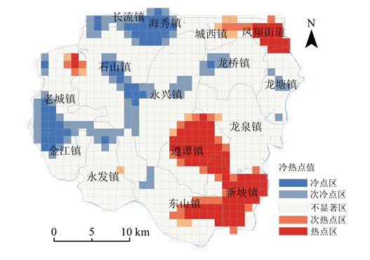
Figure 5 Hotspot map of spatial distribution of ancient tree in the Qiongbei volcanic area
| 自变量 | q值 | p值 | 回归系数均值 | 系数标准差 | 正值百分比/% | 负值百分比/% |
|---|---|---|---|---|---|---|
| 土壤质地 | 0.317 | 0.000 | −0.041 | 0.059 | 19.15 | 80.85 |
| 降雨量 | 0.187 | 0.000 | 0.012 | 0.039 | 57.93 | 42.07 |
| 土壤有机质含量 | 0.185 | 0.000 | −2.147 | 151.913 | 49.87 | 50.13 |
| 气温 | 0.179 | 0.000 | −0.989 | 3.897 | 31.83 | 68.17 |
| 日照 | 0.128 | 0.000 | 0.033 | 0.129 | 62.20 | 37.80 |
| 土壤类型 | 0.081 | 0.000 | −0.001 | 0.002 | 53.17 | 46.83 |
| 人口密度 | 0.183 | 0.000 | 1.288 | 3.660 | 68.54 | 31.46 |
| 土地利用强度指数 | 0.088 | 0.000 | −0.001 | 0.018 | 69.51 | 30.49 |
| 距传统村落距离值 | 0.040 | 0.000 | 0.000 | 0.000 | 49.27 | 50.73 |
Table 4 Correlation coefficient values of ancient tree in the Qiongbei volcanic area
| 自变量 | q值 | p值 | 回归系数均值 | 系数标准差 | 正值百分比/% | 负值百分比/% |
|---|---|---|---|---|---|---|
| 土壤质地 | 0.317 | 0.000 | −0.041 | 0.059 | 19.15 | 80.85 |
| 降雨量 | 0.187 | 0.000 | 0.012 | 0.039 | 57.93 | 42.07 |
| 土壤有机质含量 | 0.185 | 0.000 | −2.147 | 151.913 | 49.87 | 50.13 |
| 气温 | 0.179 | 0.000 | −0.989 | 3.897 | 31.83 | 68.17 |
| 日照 | 0.128 | 0.000 | 0.033 | 0.129 | 62.20 | 37.80 |
| 土壤类型 | 0.081 | 0.000 | −0.001 | 0.002 | 53.17 | 46.83 |
| 人口密度 | 0.183 | 0.000 | 1.288 | 3.660 | 68.54 | 31.46 |
| 土地利用强度指数 | 0.088 | 0.000 | −0.001 | 0.018 | 69.51 | 30.49 |
| 距传统村落距离值 | 0.040 | 0.000 | 0.000 | 0.000 | 49.27 | 50.73 |

Figure 6 Regression coefficients of factors affecting the spatial distribution of ancient tree in the Qiongbei volcanic area
| [1] |
ALI A, MATTSSON E, NISSANKA S P, 2022. Big-sized trees and species-functional diversity pathways mediate divergent impacts of environmental factors on individual biomass variability in Sri Lankan tropical forests[J]. Journal of Environmental Management, 315: 115177.
DOI URL |
| [2] |
FAISON E K, 2014. Large old tree declines at broad scales: A more complicated story[J]. Conservation Letters, 7(1): 70-71.
DOI URL |
| [3] |
FARIA D, MORANTE-FILHO J C, BAUMGARTEN J, et al., 2023. The breakdown of ecosystem functionality driven by deforestation in a global biodiversity hotspot[J]. Biological Conservation, 283: 110126.
DOI URL |
| [4] |
HARTEL T, RÉTI K-O, CRAIOVEANU C, et al., 2017. Valuing scattered trees from wood-pastures by farmers in a traditional rural region of eastern Europe[J]. Agriculture Ecosystems and Environment, 236: 304-311.
DOI URL |
| [5] |
HUANG L, TIAN L J, HUANG L L, et al., 2025. Religious temples are long-term refuges for old trees in human-dominated landscapes in China[J]. Current Biology, 35(12): 2994-3000.
DOI URL |
| [6] | HUANG L, JIN C, ZHEN M M, et al., 2020a. Biogeographic and anthropogenic factors shaping the distribution and species assemblage of heritage trees in China[J]. Urban Forestry & Urban Greening, 50: 126652. |
| [7] | HUANG L, TIAN L J, ZHOU L H, et al., 2020b. Local cultural beliefs and practices promote conservation of large old trees in an ethnic minority region in southwestern China[J]. Urban Forestry & Urban Greening, 49: 126584. |
| [8] | JIM C Y, ZHANG H, 2013. Species diversity and spatial differentiation of old-valuable trees in urban Hong Kong[J]. Urban Forestry & Urban Greening, 12(2): 171-182. |
| [9] |
KIENLE D, WALENTOWITZ A, SUNGUR L, et al., 2022. Geodiversity and biodiversity on a volcanic island: The role of scattered phonolites for plant diversity and performance[J]. Biogeosciences, 19(6): 1691-1703.
DOI URL |
| [10] |
LINDENMAYER D B, BLANCHARD W, BLAIR D, et al., 2016. Environmental and human drivers influencing large old tree abundance in Australian wet forests[J]. Forest Ecology and Management, 372: 226-235.
DOI URL |
| [11] |
LINDENMAYER D B, LAURANCE W F, FRANKLIN J F, et al., 2012. Global decline in large old trees[J]. Science, 338(6112): 1305-1306.
DOI URL |
| [12] |
LIU H B, XU W J, YU Y B, et al., 2025. Research on the construction of health risk assessment model for ancient banyan trees (Ficus microcarpa) in Fuzhou city[J]. Forests, 16(4): 703.
DOI URL |
| [13] |
LIU J J, XIA S W, ZENG D, et al., 2022. Age and spatial distribution of the world’s oldest trees[J]. Conservation Biology, 36(4): e13907.
DOI URL |
| [14] |
MEHMOOD K, ANEES S A, MUHAMMAD S, et al., 2025. Machine learning and spatio-temporal analysis for assessing ecological impacts of the billion tree afforestation project[J]. Ecology and Evolution, 15(2): e70736.
DOI URL |
| [15] |
MU Y M, LINDENMAYER D, ZHENG S L, et al., 2023. Size-focused conservation may fail to protect the world’s oldest trees[J]. Current Biology, 33(21): 4641-4649.
DOI URL |
| [16] | NIZAMANI M M, PADULLÉS CUBINO J, HARRIS A, et al., 2023. Spatial patterns and drivers of plant diversity in the tropical city of Sanya, China[J]. Urban Forestry & Urban Greening, 79: 127818. |
| [17] | PICKARSKI N, KWIECIEN O, LITT T, 2023. Volcanic impact on terrestrial and aquatic ecosystems in the eastern Mediterranean[J]. Communications Earth & Environment, 4(1): 167. |
| [18] |
STEWART FOTHERINGHAM A, CHARLTON M, BRUNSDON C, 1996. The geography of parameter space: an investigation of spatial non-stationarity[J]. International Journal of Geographical Information Systems, 10(5): 605-627.
DOI URL |
| [19] |
TIAN L X, TONG Y, CHENG Y Q, et al., 2023. Drought diminishes aboveground biomass accumulation rate during secondary succession in a tropical forest on Hainan Island, China[J]. Forest Ecology and Management, 544: 121222.
DOI URL |
| [20] |
TIAN P P, LIU Y F, LYU W, et al., 2024. Exploring influential factors on biomass and diversity of ancient trees in human-dominated regions: A case study in Guangdong Province, China[J]. Journal of Cleaner Production, 480: 143965.
DOI URL |
| [21] |
XU X Y, CUI F K, FU L Y, et al., 2024a. A pioneer tree species rapidly facilitating ecosystem restoration in coastal regions depends on soil traits[J]. Catena, 238: 107825.
DOI URL |
| [22] |
XU Z Z, XU Q, LIU K Y, et al., 2024b. Evolvement of spatio-temporal pattern and driving forces analysis of ancient trees based on the geographically weighted regression model in Guangzhou and Foshan, China[J]. Forests, 15(8): 1353.
DOI URL |
| [23] | 陈楚琳, 黄文明, 石磊, 等, 2020. 海口市羊山地区乡村聚落林地-湿地景观格局演变分析[J]. 中南林业科技大学学报, 40(2): 131-141. |
| CHEN C L, HUANG W M, SHI L, et al., 2020. Evolution analysis of forest-wetland landscape patterns of rural settlements in the Yangshan area of Haikou city[J]. Journal of Central South University of Forestry & Technology, 40(2): 131-141. | |
| [24] | 国务院, 2025. 《古树名木保护条例》. 国务院令第800号[S]. 北京: 国务院发布. |
| State Council, 2025. Regulations on the Protection of Ancient Trees and Famous Trees. State Council Order No. 800[S]. Beijing: State Council. | |
| [25] | 海南省统计局, 2021. 海南统计年鉴[M]. 北京: 中国统计出版社. |
| Hainan Provincial Bureau of Statistics, 2021. Hainan Statistical Yearbook[M]. Beijing: China Statistics Press. | |
| [26] | 呼延佼奇, 肖静, 于博威, 等, 2014. 我国自然保护区功能分区研究进展[J]. 生态学报, 34(22): 6391-6396. |
| HUYAN J Q, XIAO J, YU B W, et al., 2014. Research progress in function zoning of nature reserves in China[J]. Acta Ecologica Sinica, 34(22): 6391-6396. | |
| [27] | 李泓伯, 陈政, 2024. 常宁市古树资源特征及空间分布[J]. 中南林业科技大学学报, 44(5): 84-92. |
| LI H B, CHEN Z, 2024. Characteristics and spatial distribution of ancient tree resources in Changning City[J]. Journal of Central South University of Forestry & Technology, 44(5): 84-92. | |
| [28] | 李艳龙, 陈帅, 贺晓慧, 等, 2023. 河西地区古树名木资源特征及空间分布格局分析[J]. 西部林业科学, 52(6): 110-119. |
| LI Y L, CHEN S, HE X H, et al., 2023. Analysis of characteristics and spatial distribution pattern of ancient and famous trees in Hexi area: A case study of Wuwei City[J]. Journal of West China Forestry Science, 52(6): 110-119. | |
| [29] | 林玲, 黄川腾, 陈飞飞, 等, 2024. 海南省一级古树资源特征及空间分布格局分析[J]. 分子植物育种, 22(19): 6514-6522. |
| LIN L, HUANG C T, CHEN F F, et al., 2024. Analysis of the characteristics and spatial distribution pattern of the first-class old trees resources in Hainan Province[J]. Molecular Plant Breeding, 22(19): 6514-6522. | |
| [30] |
刘焱序, 王仰麟, 彭建, 等, 2015. 城郊聚落景观的集聚特征分析方法选择研究[J]. 地理科学, 35(6): 674-682.
DOI |
| LIU Y X, WANG Y L, PENG J, et al., 2015. Selection of different clustering algorithms for settlement landscape aggregation in suburb[J]. Scientia Geographica Sinica, 35(6): 674-682. | |
| [31] | 杨娱, 田明华, 秦国伟, 等, 2019. 城市古树名木综合价值货币化评估研究——以北京市古树 “遮荫侯” 为例[J]. 干旱区资源与环境, 33(6): 185-191. |
| YANG Y, TIAN M H, QIN G W, et al., 2019. Monetization evaluation on the comprehensive value of old and valuable trees in cities: A case study of “Marguis of Shade” in Beijing[J]. Journal of Arid Land Resources and Environment, 33(6): 185-191. | |
| [32] |
叶万辉, 曹洪麟, 黄忠良, 等, 2008. 鼎湖山南亚热带常绿阔叶林20公顷样地群落特征研究[J]. 植物生态学报, 32(2): 274-286.
DOI |
| YE W H, CAO H L, HUANG Z L, et al., 2008. Community structure of a 20 hm2 lower subtropical evergreen broadleaved forest plot in Dinghushan, China[J]. Journal of Plant Ecology (Chinese Version), 32(2): 274-286. | |
| [33] |
朱华, 2017. 中国南部热带植物区系[J]. 生物多样性, 25(2): 204-217.
DOI |
|
ZHU H, 2017. Tropical flora of southern China[J]. Biodiversity Science, 25(2): 204-217.
DOI |
|
| [34] | 庄大方, 刘纪远, 1997. 中国土地利用程度的区域分异模型研究[J]. 自然资源学报, 12(2): 10-16. |
| ZHUANG D F, LIU J Y, 1997. Study on the model of regional differentiation of land use degree in China[J]. Journal of Natural Resources, 12(2): 10-16. |
| [1] | ZHAO Shiyi, LI Jun, ZHAO Xu, HUANG Minghao, GOU Zhengyang, ZHU Haibiao, HUANG Hong. Spatial Heterogeneity and Influencing Factors of Soil Organic Carbon Fractions in Chongming Dongtan Wetland [J]. Ecology and Environmental Sciences, 2026, 35(3): 437-446. |
| [2] | LIN Wei, ZHOU Jinxing, HE Rongxiao, CHEN Zongzhu, CHEN Yiqing, WANG Yunlei, ZHONG Yunfang, LEI Jinrui. Temporal-Spatial Evolution of Ecosystem Service Value in the “Three-Space” System and Its Driving Factors in Northern Hainan [J]. Ecology and Environmental Sciences, 2025, 34(8): 1317-1328. |
| Viewed | ||||||
|
Full text |
|
|||||
|
Abstract |
|
|||||
Copyright © 2021 Editorial Office of ACTA PETROLEI SINICA
Address:No. 6 Liupukang Street, Xicheng District, Beijing, P.R.China, 510650
Tel: 86-010-62067128, 86-010-62067137, 86-010-62067139
Fax: 86-10-62067130
Email: syxb@cnpc.com.cn
Support byBeijing Magtech Co.ltd, E-mail:support@magtech.com.cn