Ecology and Environment ›› 2024, Vol. 33 ›› Issue (11): 1748-1755.DOI: 10.16258/j.cnki.1674-5906.2024.11.009
• Research Article [Environmental Science] • Previous Articles Next Articles
DING Hongwei1,2( ), GUO Tingting1, GUO Xiaohui3, LEI Ming1,2,*(), LIU Xiaoli1,2,*()
Received:2024-01-17
Online:2024-11-18
Published:2024-12-06
Contact:
LEI Ming,LIU Xiaoli
丁洪伟1,2(), 郭婷婷1, 郭晓辉3, 雷鸣1,2,*(), 刘孝利1,2,*()
通讯作者:
雷鸣,刘孝利
作者简介:丁洪伟(1999年生),男(回族),硕士,主要研究方向为水环境水生态治理。E-mail: 847568391@qq.com
基金资助:CLC Number:
DING Hongwei, GUO Tingting, GUO Xiaohui, LEI Ming, LIU Xiaoli. Spatial Characteristics and Evaluation of Water Ecological Environment in Lushui Basin during Dry Season[J]. Ecology and Environment, 2024, 33(11): 1748-1755.
丁洪伟, 郭婷婷, 郭晓辉, 雷鸣, 刘孝利. 渌水流域枯水期水生态环境空间特征及其评价[J]. 生态环境学报, 2024, 33(11): 1748-1755.
Add to citation manager EndNote|Ris|BibTeX
URL: https://www.jeesci.com/EN/10.16258/j.cnki.1674-5906.2024.11.009
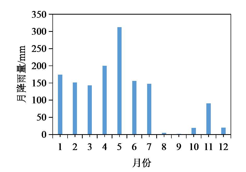
Figure 1 Monthly rainfall of Lushui basin in 2022

Figure 2 Location layout of water ecology investigation points in Lushui Basin of Zhuzhou City
| 敏感值 | 渌水流域大型底栖动物 |
|---|---|
| 10 | - |
| 9 | - |
| 8 | 溪蟹科 (Potamidae) |
| 7 | 贻贝科 (Mytilidae) |
| 6 | 田螺科 (Viviparidae)、豆螺科 (Bithyniidae)、瓶螺科 (Pilaidae) 、蚬科 (Corbiculidae)、蚌科 (Unionidae) |
| 5 | 黑螺科 (Melaniidae)、长臂虾科 (Palaemonidae)、匙指虾科 (Atyoidae) |
| 4 | - |
| 3 | 斛螺科 (Hydrobiidae)、椎实螺科 (Lymnaeidae)、摇蚊科 (Chironomidae) |
| 2 | 摇蚊亚科 (Chironominae)、直突摇蚊亚科 (Orthocladiinae) |
| 1 | 仙女虫科 (Naididae) |
Table 1 Family level sensitivity of macrobenthos in Lushui basin
| 敏感值 | 渌水流域大型底栖动物 |
|---|---|
| 10 | - |
| 9 | - |
| 8 | 溪蟹科 (Potamidae) |
| 7 | 贻贝科 (Mytilidae) |
| 6 | 田螺科 (Viviparidae)、豆螺科 (Bithyniidae)、瓶螺科 (Pilaidae) 、蚬科 (Corbiculidae)、蚌科 (Unionidae) |
| 5 | 黑螺科 (Melaniidae)、长臂虾科 (Palaemonidae)、匙指虾科 (Atyoidae) |
| 4 | - |
| 3 | 斛螺科 (Hydrobiidae)、椎实螺科 (Lymnaeidae)、摇蚊科 (Chironomidae) |
| 2 | 摇蚊亚科 (Chironominae)、直突摇蚊亚科 (Orthocladiinae) |
| 1 | 仙女虫科 (Naididae) |
| 一级 指标 | 二级 指标 | 评价等级 | ||||
|---|---|---|---|---|---|---|
| 优 | 良 | 中 | 劣 | 差 | ||
| 水生生境 | 植被覆盖率 | >80% | 60%‒80% | 40%‒60% | 20%‒40% | <20% |
| 植被分布 | 连续分布 | 半连续分布 | 丛状分布 | 分散分布 | 无植被分布 | |
| 岸线侵蚀状况 | 无明显侵蚀 | 少量侵蚀, <20% | 中度侵蚀, 20%‒50% | 极度侵蚀, 50%‒80% | 绝大部分侵蚀, >80% | |
| 表观水质 | 清澈透明、无异味 | 轻微浑浊、少量异味 | 比较浑浊、较大异味 | 很浑浊、很大异味 | 极度浑浊、恶臭味 | |
| 水量 | 水位达到两岸, 仅有少量底质裸露 | 水覆盖75%, <25%底质裸露 | 水覆盖75%, <50%底质裸露 | 水覆盖25%, 浅滩大部分裸露 | 水量很少, 几乎全部裸露 | |
| 人类活动 影响 | 岸带土地 利用类型 | 农业用地、绿地和水体面积≥75% | 75%>农业用地、 绿地和水体面积≥50%, 城镇设施用地≤25% | 50%>农业用地、绿地和水体面积≥25%, 25%<城镇设施用地<50% | 农业用地、绿地 和水体面积<25%, 城镇设施用地≥50% | 其他 |
| 人类活动强度 | 无人类活动干扰或少有人类活动 | 人类活动较少, 少量步行者或自行车通过 | 人类活动较多, 少量机动车通过 | 多种人类活动, 对河流 影响大, 但污染不严重 | 人类活动密集, 交通必经之路, 且污染严重 | |
| 护岸措施 | 植被完好, 无土壤裸露 | 植被保持一般, 部分土壤裸露, 或采用人工草皮护岸 | 植被退化, 主要为 芦苇、木桩等, 或人工砌石护岸等 | 无防护型、河水直接冲刷护岸土壤, 或钢筋混凝土护岸 | 无护岸 | |
| 河岸卫生状况 | 很好, 几乎无垃圾 | 较好, 少量垃圾 | 一般, 部分垃圾散布 | 较差, 部分垃圾堆放 | 极差, 垃圾随意堆放 | |
| 水源地可能 存在的污染源 | 无污染 | 污染影响不超过 评价区的5% | 污染影响不超过 评价区的10% | 污染影响不超过 评价区的30% | 污染影响超过 评价区的30% | |
Table 2 Habitat status evaluation index system
| 一级 指标 | 二级 指标 | 评价等级 | ||||
|---|---|---|---|---|---|---|
| 优 | 良 | 中 | 劣 | 差 | ||
| 水生生境 | 植被覆盖率 | >80% | 60%‒80% | 40%‒60% | 20%‒40% | <20% |
| 植被分布 | 连续分布 | 半连续分布 | 丛状分布 | 分散分布 | 无植被分布 | |
| 岸线侵蚀状况 | 无明显侵蚀 | 少量侵蚀, <20% | 中度侵蚀, 20%‒50% | 极度侵蚀, 50%‒80% | 绝大部分侵蚀, >80% | |
| 表观水质 | 清澈透明、无异味 | 轻微浑浊、少量异味 | 比较浑浊、较大异味 | 很浑浊、很大异味 | 极度浑浊、恶臭味 | |
| 水量 | 水位达到两岸, 仅有少量底质裸露 | 水覆盖75%, <25%底质裸露 | 水覆盖75%, <50%底质裸露 | 水覆盖25%, 浅滩大部分裸露 | 水量很少, 几乎全部裸露 | |
| 人类活动 影响 | 岸带土地 利用类型 | 农业用地、绿地和水体面积≥75% | 75%>农业用地、 绿地和水体面积≥50%, 城镇设施用地≤25% | 50%>农业用地、绿地和水体面积≥25%, 25%<城镇设施用地<50% | 农业用地、绿地 和水体面积<25%, 城镇设施用地≥50% | 其他 |
| 人类活动强度 | 无人类活动干扰或少有人类活动 | 人类活动较少, 少量步行者或自行车通过 | 人类活动较多, 少量机动车通过 | 多种人类活动, 对河流 影响大, 但污染不严重 | 人类活动密集, 交通必经之路, 且污染严重 | |
| 护岸措施 | 植被完好, 无土壤裸露 | 植被保持一般, 部分土壤裸露, 或采用人工草皮护岸 | 植被退化, 主要为 芦苇、木桩等, 或人工砌石护岸等 | 无防护型、河水直接冲刷护岸土壤, 或钢筋混凝土护岸 | 无护岸 | |
| 河岸卫生状况 | 很好, 几乎无垃圾 | 较好, 少量垃圾 | 一般, 部分垃圾散布 | 较差, 部分垃圾堆放 | 极差, 垃圾随意堆放 | |
| 水源地可能 存在的污染源 | 无污染 | 污染影响不超过 评价区的5% | 污染影响不超过 评价区的10% | 污染影响不超过 评价区的30% | 污染影响超过 评价区的30% | |
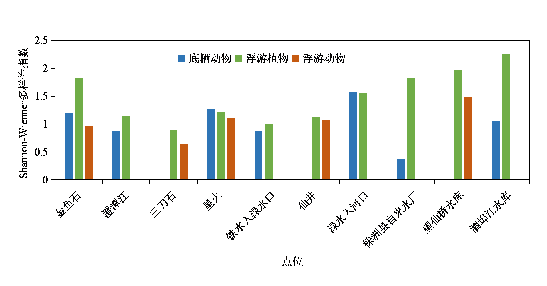
Figure 3 Biodiversity index survey results
| 多样性 指数 | 指数 含义 | 浮游植物 点位数 | 浮游动物 点位数 | 底栖动物 点位数 |
|---|---|---|---|---|
| >3.0 | 清洁 | 0 | 0 | 0 |
| 3.0‒2.0 | 轻度污染 | 1 | 0 | 0 |
| 2.0‒1.0 | 中污染 | 8 | 3 | 4 |
| 0‒1.0 | 重污染 | 1 | 4 | 3 |
| 0 | 严重污染 | 0 | 3 | 3 |
Table 3 Shannon-Wienner Diversity Index results
| 多样性 指数 | 指数 含义 | 浮游植物 点位数 | 浮游动物 点位数 | 底栖动物 点位数 |
|---|---|---|---|---|
| >3.0 | 清洁 | 0 | 0 | 0 |
| 3.0‒2.0 | 轻度污染 | 1 | 0 | 0 |
| 2.0‒1.0 | 中污染 | 8 | 3 | 4 |
| 0‒1.0 | 重污染 | 1 | 4 | 3 |
| 0 | 严重污染 | 0 | 3 | 3 |
| 点位名称 | BMWP指数计分 | 评价等级 |
|---|---|---|
| 金鱼石 | 20 | 差 |
| 澄潭江 | 15 | 差 |
| 三刀石断面 | 5 | 劣 |
| 星火断面 | 27 | 中 |
| 铁水入渌水断面 | 17 | 差 |
| 仙井断面 | 6 | 劣 |
| 渌水入湘江口 | 28 | 中 |
| 株洲县自来水取水口 | 12 | 差 |
| 望仙桥水库 | 6 | 劣 |
| 酒埠江水库 | 32 | 中 |
Table 4 BMWP index evaluation results
| 点位名称 | BMWP指数计分 | 评价等级 |
|---|---|---|
| 金鱼石 | 20 | 差 |
| 澄潭江 | 15 | 差 |
| 三刀石断面 | 5 | 劣 |
| 星火断面 | 27 | 中 |
| 铁水入渌水断面 | 17 | 差 |
| 仙井断面 | 6 | 劣 |
| 渌水入湘江口 | 28 | 中 |
| 株洲县自来水取水口 | 12 | 差 |
| 望仙桥水库 | 6 | 劣 |
| 酒埠江水库 | 32 | 中 |
| 监测点位 | 生境情况 |
|---|---|
| L1金鱼石 | 砾石, 砾石上附着泥沙明显 |
| L2澄潭江 | 砾石, 泥沙, 砾石附着泥沙明显, 附近有排污口, 蜗牛螺类个体较大 |
| L3三刀石 | 泥沙, 淤泥为主, 有死亡螺类, 有虾米, 两岸蔬菜种植普遍 |
| L4星火 | 底质泥沙、沙粒, 水流缓慢, 有滞留水葫芦等, 死亡贝类很多 |
| L5铁水入渌水口 | 沙粒, 砾石, 水质良好, 沉水植物以苦草为主, 生物量大, 流速较快 |
| L6仙井 | 底质泥沙, 沉水植物不多, 以苦草为主, 流速缓慢, 有漂浮滞留的凋落苦草与水葫芦, 泥土岸线, 水浪冲击易浑浊 |
| L7渌水入河口 | 底质石块、砾石、沙粒为主, 但砾石石块附着泥土明显, 枯水期湘江水有倒灌可能, 采样时水质良好, 蜗牛螺类个体较大, 清澈见底, 尚未生长出沉水植物, 有海绵, 泥沙岸线 |
| L8株洲县自来水厂 | 砾石、沙粒底质, 水流缓慢, 砾石岸线, 无明显沉水植物 |
| L9望仙桥水库 | 底质砾石、沙, 水质清澈, 底栖动物不多 |
| L10酒埠江水库 | 中小砾石、沙粒底质, 水质清澈, 无明显沉水植物 |
Table 5 Survey results of habitat basic conditions
| 监测点位 | 生境情况 |
|---|---|
| L1金鱼石 | 砾石, 砾石上附着泥沙明显 |
| L2澄潭江 | 砾石, 泥沙, 砾石附着泥沙明显, 附近有排污口, 蜗牛螺类个体较大 |
| L3三刀石 | 泥沙, 淤泥为主, 有死亡螺类, 有虾米, 两岸蔬菜种植普遍 |
| L4星火 | 底质泥沙、沙粒, 水流缓慢, 有滞留水葫芦等, 死亡贝类很多 |
| L5铁水入渌水口 | 沙粒, 砾石, 水质良好, 沉水植物以苦草为主, 生物量大, 流速较快 |
| L6仙井 | 底质泥沙, 沉水植物不多, 以苦草为主, 流速缓慢, 有漂浮滞留的凋落苦草与水葫芦, 泥土岸线, 水浪冲击易浑浊 |
| L7渌水入河口 | 底质石块、砾石、沙粒为主, 但砾石石块附着泥土明显, 枯水期湘江水有倒灌可能, 采样时水质良好, 蜗牛螺类个体较大, 清澈见底, 尚未生长出沉水植物, 有海绵, 泥沙岸线 |
| L8株洲县自来水厂 | 砾石、沙粒底质, 水流缓慢, 砾石岸线, 无明显沉水植物 |
| L9望仙桥水库 | 底质砾石、沙, 水质清澈, 底栖动物不多 |
| L10酒埠江水库 | 中小砾石、沙粒底质, 水质清澈, 无明显沉水植物 |
| 一级 指标 | 二级 指标 | 评估等级 | |||||||||
|---|---|---|---|---|---|---|---|---|---|---|---|
| L1 | L2 | L3 | L4 | L5 | L6 | L7 | L8 | L9 | L10 | ||
| 自然生境 | 植被覆盖率 | 良 | 优 | 优 | 优 | 优 | 优 | 优 | 良 | 优 | 良 |
| 植被分布 | 良 | 优 | 优 | 优 | 优 | 良 | 优 | 良 | 优 | 良 | |
| 岸线侵蚀状况 | 良 | 良 | 良 | 优 | 良 | 良 | 优 | 优 | 良 | 优 | |
| 表观水质 | 优 | 优 | 良 | 优 | 优 | 良 | 优 | 优 | 优 | 优 | |
| 水量 | 优 | 优 | 优 | 优 | 优 | 优 | 优 | 优 | 优 | 优 | |
| 人类活动影响 | 岸带土地 利用类型 | 优 | 优 | 优 | 优 | 优 | 优 | 优 | 优 | 优 | 优 |
| 人类活动强度 | 优 | 优 | 劣 | 良 | 中 | 优 | 中 | 优 | 优 | 优 | |
| 护岸措施 | 良 | 良 | 良 | 优 | 优 | 良 | 良 | 良 | 良 | 优 | |
| 河岸卫生状况 | 优 | 优 | 劣 | 良 | 优 | 中 | 优 | 优 | 优 | 优 | |
| 水源地可能存在的污染源 | 优 | 优 | 优 | 优 | 优 | 优 | 优 | 优 | 优 | 优 | |
Table 6 Evaluation results of aquatic habitat in Lushui Basin
| 一级 指标 | 二级 指标 | 评估等级 | |||||||||
|---|---|---|---|---|---|---|---|---|---|---|---|
| L1 | L2 | L3 | L4 | L5 | L6 | L7 | L8 | L9 | L10 | ||
| 自然生境 | 植被覆盖率 | 良 | 优 | 优 | 优 | 优 | 优 | 优 | 良 | 优 | 良 |
| 植被分布 | 良 | 优 | 优 | 优 | 优 | 良 | 优 | 良 | 优 | 良 | |
| 岸线侵蚀状况 | 良 | 良 | 良 | 优 | 良 | 良 | 优 | 优 | 良 | 优 | |
| 表观水质 | 优 | 优 | 良 | 优 | 优 | 良 | 优 | 优 | 优 | 优 | |
| 水量 | 优 | 优 | 优 | 优 | 优 | 优 | 优 | 优 | 优 | 优 | |
| 人类活动影响 | 岸带土地 利用类型 | 优 | 优 | 优 | 优 | 优 | 优 | 优 | 优 | 优 | 优 |
| 人类活动强度 | 优 | 优 | 劣 | 良 | 中 | 优 | 中 | 优 | 优 | 优 | |
| 护岸措施 | 良 | 良 | 良 | 优 | 优 | 良 | 良 | 良 | 良 | 优 | |
| 河岸卫生状况 | 优 | 优 | 劣 | 良 | 优 | 中 | 优 | 优 | 优 | 优 | |
| 水源地可能存在的污染源 | 优 | 优 | 优 | 优 | 优 | 优 | 优 | 优 | 优 | 优 | |
| 项目 | 底栖动物 | 浮游植物 | 浮游动物 | 平均值 |
|---|---|---|---|---|
| 高锰酸盐指数 | -0.179 | -0.592* | -0.167 | -0.463* |
| 生化需氧量 | 0.013 | -0.646** | -0.053 | -0.314 |
| 化学需氧量 | 0.087 | -0.306 | 0.106 | 0.092 |
| 氟化物 | 0.374 | -0.176 | 0.191 | 0.200 |
| 溶解氧 | -0.547* | 0.012 | 0.034 | -0.365 |
| 氨氮 | -0.147 | -0.316 | 0.336 | -0.079 |
| 总磷 | 0.546* | 0.389 | 0.233 | 0.740** |
| pH | 0.400* | 0.208 | 0.323 | 0.476* |
| 合计 | 0.436* | 0.042 | 0.179 | 0.394 |
Table 7 Spearman correlation analysis results
| 项目 | 底栖动物 | 浮游植物 | 浮游动物 | 平均值 |
|---|---|---|---|---|
| 高锰酸盐指数 | -0.179 | -0.592* | -0.167 | -0.463* |
| 生化需氧量 | 0.013 | -0.646** | -0.053 | -0.314 |
| 化学需氧量 | 0.087 | -0.306 | 0.106 | 0.092 |
| 氟化物 | 0.374 | -0.176 | 0.191 | 0.200 |
| 溶解氧 | -0.547* | 0.012 | 0.034 | -0.365 |
| 氨氮 | -0.147 | -0.316 | 0.336 | -0.079 |
| 总磷 | 0.546* | 0.389 | 0.233 | 0.740** |
| pH | 0.400* | 0.208 | 0.323 | 0.476* |
| 合计 | 0.436* | 0.042 | 0.179 | 0.394 |
| [1] | KAMENIR Y, DUBINSKY Z, ZOHARY T, 2004. Phytoplankton size structure stability in a meso-eutrophic subtropical lake[J]. Hydrobiologia, 520(1): 89-104. |
| [2] | MICHAEL J, TENTE J, 1990. Seasonal patterns of grazing and nutrient limitation of phytoplankton in a eutrophic lake[J]. Limnology and Oceanography, 35(3): 697-709. |
| [3] | STEPHEN T, 1983. Spatial and temporal variation in the summer zooplankton community of a riverine reservoir[J]. Hydrobiologia, 107(3): 249-254. |
| [4] | WETZEL R, 2001. Limnology, Lake and River Ecosystems[J]. Journal of Phycology, 37(6): 1146-1147. |
| [5] | 陈淼, 苏晓磊, 党成强, 等, 2017. 三峡水库河流生境评价指标体系构建及应用[J]. 生态学报, 37(24): 8433-8444. |
| CHEN M, SU X L, DANG C Q, et al., 2017. Construction and application of riverine habitat evaluation index system in Three Gorges Reservoir[J]. Acta Ecologica Sinica, 37(24): 8433-8444. | |
| [6] | 郭坤, 彭婷, 罗静波, 等, 2017. 长湖浮游动物群落结构及其与环境因子的关系[J]. 海洋与湖沼, 48(1): 40-49. |
| GUO K, PENG T, LUO J B, et al., 2017. Zooplankton community structure and its relationship with environmental factors in long lake[J]. Oceanologia et Limnologia Sinica, 48(1): 40-49. | |
| [7] |
胡芳, 刘聚涛, 温春云, 等, 2023. 抚河流域浮游植物群落结构特征及其水生态状况评价[J]. 生态环境学报, 32(4): 744-755.
DOI |
| HU F, LIU J T, WEN C Y, et al., 2023. Phytoplankton community structure and evaluation of aquatic ecological conditions in Fu River basin[J]. Journal of Ecological Environment, 32(4): 744-755. | |
| [8] | 况琪军, 马沛明, 胡征宇, 等, 2005. 湖泊富营养化的藻类生物学评价与治理研究进展[J]. 安全与环境学报, 5(2): 87-91. |
| KUANG Q J, MA P M, HU Z Y, et al., 2005. Research progress on biological evaluation and management of algae in lake eutrophication[J]. Journal of Safety and Environment, 5(2): 87-91. | |
| [9] | 林秋奇, 赵帅营, 韩博平, 2006. 广东流溪河水库后生浮游动物生物量谱时空异质性[J]. 湖泊科学, 18(6): 661-669. |
| LIN Q Q, ZHAO S Y, HAN B P, 2006. Temporal and spatial heterogeneity of epigenetic zooplankton biomass spectrum in Liuxihe Reservoir, Guangdong Province[J]. Journal of Lake Sciences, 18(6): 661-669. | |
| [10] | 冷龙龙, 渠晓东, 张海萍, 等, 2016. 不同大型底栖动物快速生物评价指数对河流水质指示比较[J]. 环境科学研究, 29(6): 819-828. |
| LENG L L, QU X D, ZHANG H P, et al., 2016. Comparison of indicator of river water quality by rapid bioassessment index of different macrobenthos[J]. Research of Environmental Sciences, 29(6): 819-828. | |
| [11] | 吕忠梅, 2021. 《长江保护法》适用的基础性问题[J]. 环境保护, 49(Z1): 23-29. |
| LÜ Z M, 2021. Basic problems of the application of the Yangtze River Protection Law[J]. Environmental Protection, 49(Z1): 23-29. | |
| [12] | 米振琴, 谢骏, 潘德博, 等, 1999. 精养虾池浮游植物、理化因子与虾病的关系[J]. 上海水产大学学报 (4): 304-308. |
| MI Z Q, XIE J, PAN D B, et al., 1999. Relationship between phytoplankton, physicochemical factors and shrimp disease in intensive shrimp ponds[J]. Journal of Shanghai Fisheries University (4): 304-308. | |
| [13] | 秦容, 高飞, 张芹, 等, 2022. 浮游植物分析法解析御临河流域水环境质量现状[J]. 四川环境, 41(6): 138-143. |
| QIN R, GAO F, ZHANG Q, et al., 2022. Analysis of water environment quality in Yulin River Basin by phytoplankton analysis[J]. Sichuan Environment, 41(6): 138-143. | |
| [14] | 钱玺亦, 李金彪, 敖文, 等, 2022. 呼伦湖浮游植物群落季节动态及其与环境因子的关系[J]. 湖泊科学, 34(6): 1814-1827. |
| QIAN X Y, LI J B, AO W, et al., 2022. Seasonal dynamics of phytoplankton community and its relationship with environmental factors in Hulun Lake[J]. Lake Science, 34(6): 1814-1827. | |
| [15] | 渠晓东, 陈军, 陈皓阳, 等, 2021. 大型底栖动物快速生物评价指数在城市河流生态评估中的应用[J]. 水生态学杂志, 42(3): 14-22. |
| QU X D, CHEN J, CHEN H Y, et al., 2021. Application of rapid bioassessment index of macrobenthos in urban river ecological assessment[J]. Journal of Hydroecology, 42(3): 14-22. | |
| [16] | 王建华, 胡鹏, 2018. 我国水生态文明建设内涵、评价标准与经验模式[J]. 中国水利水电科学研究院学报, 16(5): 430-436. |
| WANG J H, HU P, 2018. Connotation, evaluation criteria and empirical model of water ecological civilization construction in China[J]. Journal of China Institute of Water Resources and Hydropower Research, 16(5): 430-436. | |
| [17] | 王琼, 范志平, 李法云, 等, 2015. 蒲河流域河流生境质量综合评价及其与水质响应关系[J]. 生态学杂志, 34(2): 516-523. |
| WANG Q, FAN Z P, LI F Y, et al., 2015. Comprehensive assessment of river habitat quality and its response to water quality in Puhe River Basin[J]. Chinese Journal of Ecology, 34(2): 516-523. | |
| [18] | 汪青辽, 颜小平, 郝红升, 等, 2021. 我国大中型水库水体自净能力特征研究[J]. 水力发电, 47(9): 21-26. |
| WANG Q L, YAN X P, HAO H S, et al., 2021. Study on characteristics of self-purification capacity of large and medium-sized reservoirs in China[J]. Hydropower Generation, 47(9): 21-26. | |
| [19] | 王艺兵, 侯泽英, 叶碧碧, 等, 2015. 鄱阳湖浮游植物时空变化特征及影响因素分析[J]. 环境科学学报, 35(5): 1310-1317. |
| WANG Y B, HOU Z Y, YE B B, et al., 2015. Spatial and temporal variation of phytoplankton in Poyang Lake and its influencing factors[J]. Chinese Journal of Environmental Science, 35(5): 1310-1317. | |
| [20] | 徐敏, 秦顺兴, 马乐宽, 等, 2021. 水生态环境保护回顾与展望: 从污染防治到三水统筹[J]. 中国环境管理, 13(5): 69-78. |
| XU M, QIN S X, MA L K, et al., 2021. Review and prospect of water ecological environment protection: From pollution prevention to three-water overall planning[J]. Environmental Management in China, 13(5): 69-78. | |
| [21] | 徐维忠, 1998. 酒埠江水库的浮游生物及其银鱼鱼产潜力的估算[J]. 内陆水产 (12): 3-5. |
| XU W Z, 1998. Estimation of plankton and its potential production of whitebait in Jiubujiang Reservoir[J]. Inland Fisheries (12): 3-5. | |
| [22] | 杨宇峰, 王庆, 陈菊芳, 等, 2006. 河口浮游动物生态学研究进展[J]. 生态学报, 26(2): 576-585. |
| YANG Y F, WANG Q, CHEN J F, et al., 2006. Research progress of estuarine zooplankton ecology[J]. Acta Ecologica Sinica, 26(2): 576-585. | |
| [23] | 杨玉霞, 沈强, 胡俊, 等, 2019. 石头河水库浮游生物群落结构及水生态评价[J]. 水生态学杂志, 40(6): 24-29. |
| YANG Y X, SHEN Q, HU J, et al., 2019. Plankton community structure and evaluation of water ecology in Shitou River Reservoir[J]. Chinese Journal of Water Ecology, 40(6): 24-29. | |
| [24] |
杨朝霞, 李畅游, 史小红, 等, 2019. 呼伦湖水体营养状态特征及其主要影响因子研究[J]. 生态环境学报, 28(11): 2273-2280.
DOI |
| YANG Z X, LI C Y, SHI XH, et al., 2019. Study on the characteristics of water nutrition status and its main influencing factors in Hulun Lake[J]. Chinese Journal of Ecology and Environment, 28(11): 2273-2280. | |
| [25] | 闫世雄, 2020. 渌水流域城市扩张的洪水响应研究[D]. 长沙: 长沙理工大学: 9-10. |
| YAN S X, 2020. Study on flood response of urban expansion in Lushui Basin[D]. Changsha: Changsha University of Science and Technology: 9-10. | |
| [26] | 张爱平, 2009. 宁夏黄灌区稻田退水氮磷污染特征研究[D]. 北京: 中国农业科学院: 124. |
| ZHANG A P, 2009. Study on nitrogen and phosphorus pollution characteristics of rice field runoff in Huangirrigan District of Ningxia[D]. Beijing: Chinese Academy of Agricultural Sciences: 124. | |
| [27] | 张西林, 2005. 大型水库旅游开发中的水资源利用——以湖南酒埠江水库为例[J]. 国土资源科技管理, 22(3): 71-74. |
| ZHANG X L, 2005. Water resource utilization in tourism devel opment of large reservoirs: A case study of Jiubujiang Reservoir in Hunan Province[J]. Science and Technology Management of Land Resources, 22(3): 71-74. | |
| [28] | 张艳强, 王远飞, 王黎瑾, 等, 2019. 丽水市黄村水库水系浮游动物生态特征及影响因子[J]. 上海师范大学学报(自然科学版), 48(4): 441-448. |
| ZHANG Y Q, WANG Y F, WANG L J, et al., 2019. Ecological characteristics and influencing factors of zooplankton in Huangcun Reservoir of Lishui City[J]. Journal of Shanghai Normal University (Natural Science Edition), 48(4): 441-448. | |
| [29] | 赵璐, 欧阳添, 纪璐璐, 等, 2023. 三峡水库蓄水对支流浮游植物功能群的影响及与资源利用效率的关系[J]. 环境科学, 44(2): 857-867. |
| ZHAO L, OUYANG T, JI L L, et al., 2023. Effects of water storage on phytoplankton functional groups in tributaries of the Three Gorges Reservoir and its relationship with resource use efficiency[J]. Environmental Science, 44(2): 857-867. | |
| [30] | 郑诚, 2022. 水环境保护管理现状和措施研究[J]. 资源节约与环保 (4): 23-26. |
| ZHENG C, 2022. Research on status quo and measures of water environmental protection management[J]. Resources Conservation and Environmental Protection (4): 23-26. | |
| [31] | 朱明明, 范存祥, 吴中奎, 等, 2020. 海珠国家湿地公园浮游植物群落结构时空变化[J]. 生态学杂志, 39(5): 1501-1508. |
| ZHU M M, FAN C X, WU Z K, et al., 2020. Spatial and temporal changes of phytoplankton community structure in Haizhu National Wetland Park[J]. Chinese Journal of Ecology, 39(5): 1501-1508. | |
| [32] | 左其亭, 2013. 水生态文明建设几个关键问题探讨[J]. 中国水利 (4): 1-3, 6. |
| ZUO Q T, 2013. Discussion on several key issues in the construction of water ecological civilization[J]. China Water Resources (4): 1-3, 6. | |
| [33] | 左其亭, 胡德胜, 窦明, 等, 2014. 基于人水和谐理念的最严格水资源管理制度研究框架及核心体系[J]. 资源科学, 36(5): 906-912. |
| ZUO Q T, HU D S, DOU M, et al., 2014. Research framework and core system of the strictest water resources management system based on the concept of harmony between human and water[J]. Resources Science, 36(5): 906-912. | |
| [34] | 国家环境保护总局, 国家质量监督检验检疫总局, 2002. 地表水环境质量标准: GB 3838—2002[S]. 北京: 中国环境出版社: 2. |
| State Environmental Protection Administration, State Administration of Quality Supervision, Inspection and Quarantine, 2002. Surface water environmental quality standard: GB 3838—2002[S]. Beijing: China Environmental Press: 2. |
| [1] | GAO Wenming, SONG Qian, ZHANG Haoxiang, WANG Shiru. Selection of Priority Conservation Areas Based on Ecosystem Service Functions and Wildlife Habitat Suitability Evaluation: A Case Study in the Sanjiang-yuan Region [J]. Ecology and Environment, 2024, 33(8): 1318-1328. |
| [2] | LI Haiyan, YANG Tao, LIAO Yilin, QU Yajie. Analysis of Distribution Pattern and Driving Habitat Quality of Rivers in the Wei River Basin (Shaanxi section) [J]. Ecology and Environment, 2024, 33(7): 1153-1162. |
| [3] | XIANG Nan, WANG Mingxu, ZHANG Hongfeng, LIAO Baogan. Research on Zoning of Ecological Conservation Importance and Its Spatio-temporal Differentiation of Habitat Status Over a Long Time Sequence: A Case Study in Guangdong Province [J]. Ecology and Environment, 2024, 33(6): 958-968. |
| [4] | QING Caixia, CHEN Shengbin, DENG Jiewen, DENG Xingwei, LI Zhe, QIU Lu. The Effects of Habitat Amount, Habitat Quality and Meteorological Factors on the Species Diversity of Dung Beetles in Chengdu [J]. Ecology and Environment, 2024, 33(5): 708-719. |
| [5] | TIAN Xuchen, WEI Hongling, XIE Shengnan, CHU Qiming, YANG Jing, ZHANG Ying, XIAO Siqiu, TANG Zonghua, LIU Ying, LI Dewen. Potential Geographical Distribution of Acer in Northeast China Based on the MaxEnt Model [J]. Ecology and Environment, 2024, 33(4): 509-519. |
| [6] | ZHANG Chuanguang, SHEN Yan, ZHANG Shanshan, LI Yuwen, CHEN Jian, YANG Wenzhong. Analysis of Microbial Diversity of Rhizosphere Soil of Pinus wangii (Pinaceae) in In Situ and Ex Situ Conservation [J]. Ecology and Environment, 2024, 33(10): 1544-1553. |
| [7] | XU Jing, LIAO Xingkai, GAN Qixu, ZHOU Maoxian. Construction of Ecological Security Pattern Based on MSPA and Circuit Theory in Gansu Section of the Yellow River Basin [J]. Ecology and Environment, 2023, 32(4): 805-813. |
| [8] | ZHOU Shiqiang, Vanessa HULL, ZHANG Jindong, LIU Dian, XIE Hao, HUANG Jinyan, ZHANG Hemin. Comparison of Habitat Use Patterns between Wild Giant Pandas and Grazing Livestock [J]. Ecology and Environment, 2023, 32(2): 309-319. |
| [9] | HUANG Guofeng, HE Bin, XIE Zhiyi, LIU Jun, WANG Anhou, LIAO Tong, WANG Bojin, HAO Beibei. Impact of Agricultural Pollution on Water Environment and Its Spatial Differentiation pattern in Guangdong Province [J]. Ecology and Environment, 2023, 32(12): 2207-2215. |
| [10] | CHEN Xiaonan, LI Qiongwen, YU Jianping, YU Shunhai, LI Shuang, CAO Mingchang. Habitat Suitability Assessment of Syrmaticus ellioti in the Qiangjiangyuan National Park [J]. Ecology and Environment, 2022, 31(9): 1832-1839. |
| [11] | CHEN Le, WEI Wei. Spatiotemporal Changes in Land Use and Habitat Quality in A Typical Dryland Watershed of Northwest China [J]. Ecology and Environment, 2022, 31(9): 1909-1918. |
| [12] | YUAN Chunming, YANG Guoping, GENG Yunfen, ZHANG Shanshan. Prediction of Population Dynamics of the Endangered Plant Pterospermum kingtungense Using Integral Projection Models [J]. Ecology and Environment, 2022, 31(8): 1530-1536. |
| [13] | FU Yuhong, ZHANG Daijie, XIANG Jiao, ZHOU Yan, HUANG Zongsheng, YU Lifei. Topological Structure of Plant Roots of Different Underground Habitat Profiles in Karst Areas [J]. Ecology and Environment, 2022, 31(5): 865-874. |
| [14] | DONG Xin, LANG Jiayu, CHUYUAN Mengran, ZHAO Shanshan, ZHANG Jindong, BAI Wenke. The Seasonal Characteristics of Home Range and Habitat Utilization of Sichuan Golden Monkeys (Rhinopithecus roxellana) [J]. Ecology and Environment, 2021, 30(7): 1342-1352. |
| [15] | TA Weiyuan, KANG Zhen, MENG Zhaojun, JIN Shenghua, YANG Xing, GUO Longfei, ZHAO Dongxu, ZHANG Xin. Research of Pollution Characteristics of Heavy Metals in Soil of Typical Closed Zinc Smelting Enterprises in Qinling Mountains [J]. Ecology and Environment, 2021, 30(7): 1513-1521. |
| Viewed | ||||||
|
Full text |
|
|||||
|
Abstract |
|
|||||
Copyright © 2021 Editorial Office of ACTA PETROLEI SINICA
Address:No. 6 Liupukang Street, Xicheng District, Beijing, P.R.China, 510650
Tel: 86-010-62067128, 86-010-62067137, 86-010-62067139
Fax: 86-10-62067130
Email: syxb@cnpc.com.cn
Support byBeijing Magtech Co.ltd, E-mail:support@magtech.com.cn