Ecology and Environment ›› 2021, Vol. 30 ›› Issue (12): 2275-2284.DOI: 10.16258/j.cnki.1674-5906.2021.12.001
• Research Articles • Next Articles
HUANG Dong1,2( ), LI Peng1,2, DONG Nan3,*()
Received:2021-03-19
Online:2021-12-18
Published:2022-01-04
Contact:
DONG Nan
黄栋1,2(), 李鹏1,2, 董南3,*()
通讯作者:
董南
作者简介:黄栋(1989年生),女,讲师,博士,研究方向为资源环境数据分析与应用。E-mail: imdon@126.com
基金资助:CLC Number:
HUANG Dong, LI Peng, DONG Nan. Spatial-temporal Differentiation of GS_NDVI in Recent 20 Years and Its Responses to Climate Change and LUCC in the Bohai Coastal Region[J]. Ecology and Environment, 2021, 30(12): 2275-2284.
黄栋, 李鹏, 董南. 近20 a环渤海地区GS_NDVI时空分异及其对气候变化和LUCC的响应[J]. 生态环境学报, 2021, 30(12): 2275-2284.
Add to citation manager EndNote|Ris|BibTeX
URL: https://www.jeesci.com/EN/10.16258/j.cnki.1674-5906.2021.12.001
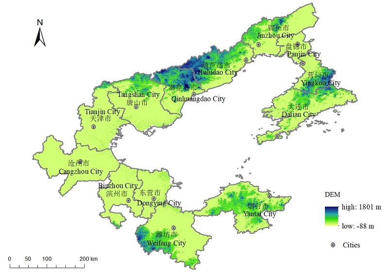
Fig. 1 Overview of the study area
| 数据名称 Name of the data | 数据格式 Data type | 数据时相 Data time | 空间分辨率与比例尺 Resolution and Scale | 数据来源 Data sources |
|---|---|---|---|---|
| 市行政边界 Boundary of the cities | 矢量 Vector | 2015 | 1:100000 | RESDC |
| 土地利用数据 Land use | 栅格 Grid | 2000/2010/2018 | 1 km | RESDC |
| DEM | 栅格 Grid | 2000 | 30m | RESDC |
| 气象站点 Meteorological stations | 矢量 Vector | 2010 | — | CMDSC |
| 降水、气温数据 Precipitation and temperature data | 文本 Text | 2000—2018 | — | CMDSC |
| 中国季度植被指数空间分布数据 Spatial distribution dataset of quarterly NDVI of China | 栅格 Grid | 2000—2018 | 1 km | RESDC |
Table 1 Data sources
| 数据名称 Name of the data | 数据格式 Data type | 数据时相 Data time | 空间分辨率与比例尺 Resolution and Scale | 数据来源 Data sources |
|---|---|---|---|---|
| 市行政边界 Boundary of the cities | 矢量 Vector | 2015 | 1:100000 | RESDC |
| 土地利用数据 Land use | 栅格 Grid | 2000/2010/2018 | 1 km | RESDC |
| DEM | 栅格 Grid | 2000 | 30m | RESDC |
| 气象站点 Meteorological stations | 矢量 Vector | 2010 | — | CMDSC |
| 降水、气温数据 Precipitation and temperature data | 文本 Text | 2000—2018 | — | CMDSC |
| 中国季度植被指数空间分布数据 Spatial distribution dataset of quarterly NDVI of China | 栅格 Grid | 2000—2018 | 1 km | RESDC |
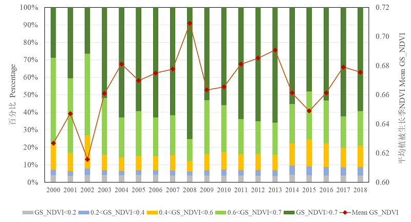
Fig. 2 Interannual variation of percentage and regional average GS_NDVI during 2000—2018

Fig. 3 The mean GS_NDVI during the period of 2000 to 2018 and the changing value of GS_NDVI from 2000 to 2018 at 1 km pixel scale
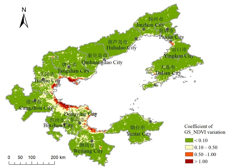
Fig. 4 Coefficient of GS_NDVI variation at pixel scale
| 变异系数 Cvariation | 分类 Classification | 面积占比/% Area ratio/% |
|---|---|---|
| Cvariation<0.10 | 弱变异 Weak variation | 82.04 |
| 0.10<Cvariation<0.50 | 中等变异 Medium variation | 15.07 |
| 0.50<Cvariation<1.00 | 较强变异 Strong variation | 1.98 |
| Cvariation>1.00 | 强变异 Very strong variation | 0.91 |
Table 2 The area ratios of different kind of CV
| 变异系数 Cvariation | 分类 Classification | 面积占比/% Area ratio/% |
|---|---|---|
| Cvariation<0.10 | 弱变异 Weak variation | 82.04 |
| 0.10<Cvariation<0.50 | 中等变异 Medium variation | 15.07 |
| 0.50<Cvariation<1.00 | 较强变异 Strong variation | 1.98 |
| Cvariation>1.00 | 强变异 Very strong variation | 0.91 |
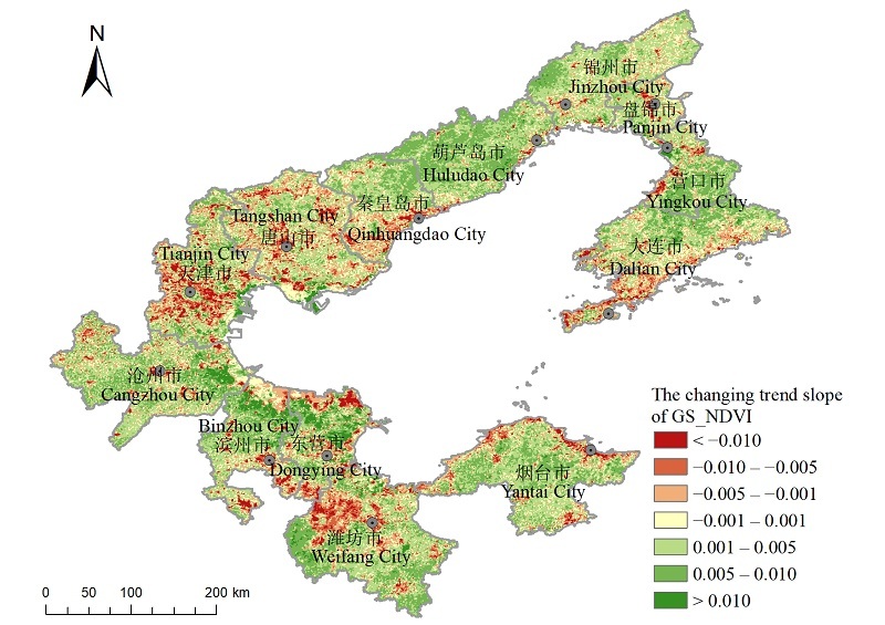
Fig. 5 Spatial changing trend of GS_NDVI at pixel scale
| 变化趋势斜率 Slope of the changing trend | 变化程度 Changing degree | 面积占比 Area ratio/% |
|---|---|---|
| <-0.010 | 明显退化 Obvious degradation | 3.97 |
| -0.010— -0.005 | 中度退化 Medium degradation | 6.96 |
| -0.005— -0.001 | 轻度退化 Light degradation | 13.70 |
| -0.001—0.001 | 基本不变 Unchanged | 13.13 |
| 0.001—0.005 | 轻度改善 Light improvement | 36.23 |
| 0.005—0.010 | 中度改善 Medium improvement | 23.28 |
| >0.010 | 明显改善 Obvious improvement | 2.71 |
Table 3 The changing degree and area ratios of different changing trend
| 变化趋势斜率 Slope of the changing trend | 变化程度 Changing degree | 面积占比 Area ratio/% |
|---|---|---|
| <-0.010 | 明显退化 Obvious degradation | 3.97 |
| -0.010— -0.005 | 中度退化 Medium degradation | 6.96 |
| -0.005— -0.001 | 轻度退化 Light degradation | 13.70 |
| -0.001—0.001 | 基本不变 Unchanged | 13.13 |
| 0.001—0.005 | 轻度改善 Light improvement | 36.23 |
| 0.005—0.010 | 中度改善 Medium improvement | 23.28 |
| >0.010 | 明显改善 Obvious improvement | 2.71 |
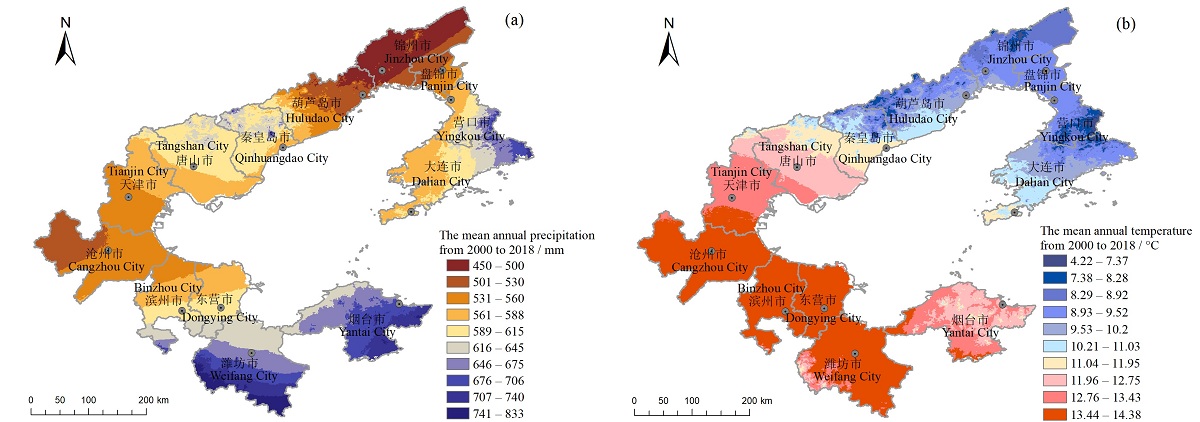
Fig. 6 Mean annual precipitation and temperature during the period of 2000 to 2018
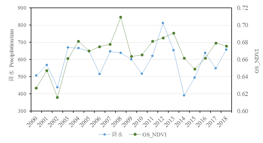
Fig. 7 Correlation between GS_NDVI and precipitation at regional scale
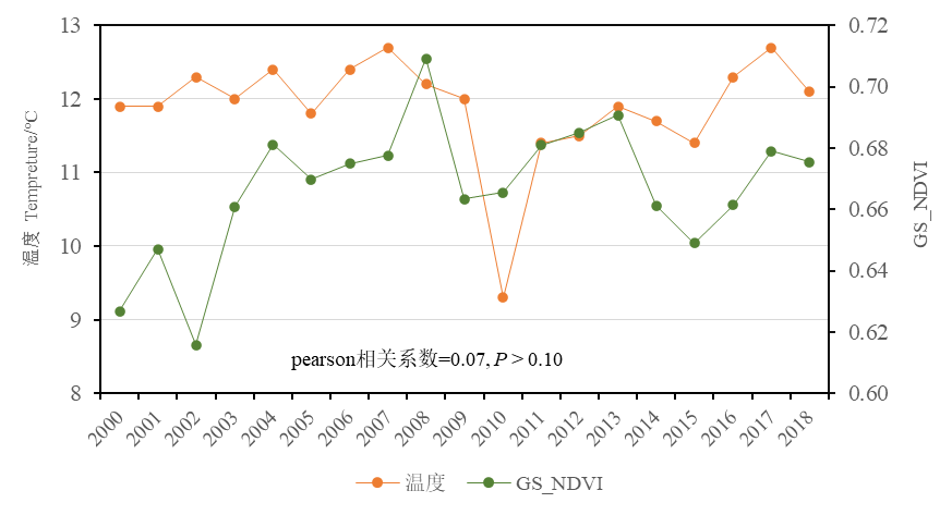
Fig. 8 Correlation between GS_NDVI and temperature at regional scale
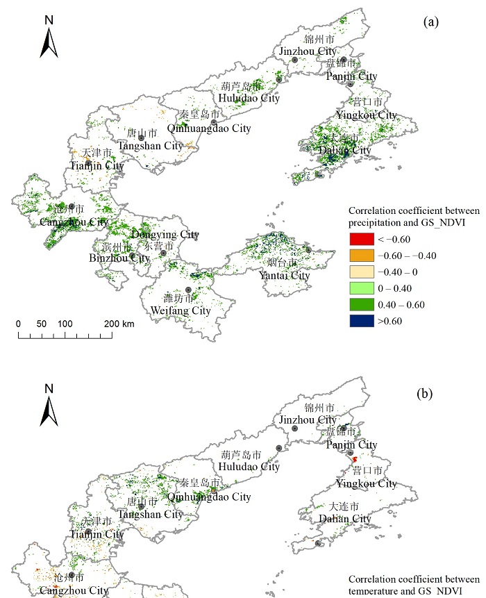
Fig. 9 Spatial distribution of correlation coefficient of GS_NDVI and climate factors at pixel scale
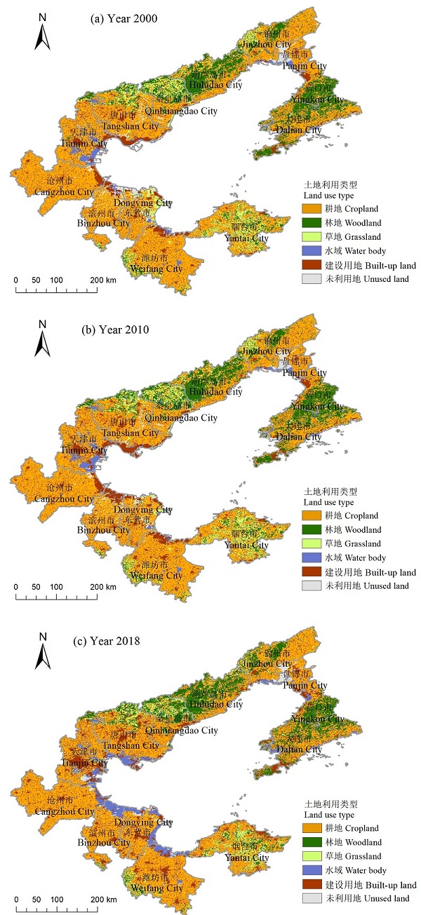
Fig. 10 Spatial distribution of land use at 2000, 2010 and 2018
| 土地利用类型 Land use type | 2000年 Year 2000 | 2010年 Year 2010 | 2018年 Year 2018 | |||||
|---|---|---|---|---|---|---|---|---|
| 面积 Area/ km2 | 面积占比 Area ratio/ % | 面积 Area/ km2 | 面积占比 Area ratio/ % | 面积 Area/ km2 | 面积占比 Area ratio/ % | |||
| 耕地 Cropland | 77237 | 57.01 | 76638 | 56.57 | 73565 | 54.30 | ||
| 林地 Woodland | 20679 | 15.26 | 20608 | 15.21 | 20652 | 15.24 | ||
| 草地 Grassland | 9902 | 7.31 | 9170 | 6.77 | 6851 | 5.06 | ||
| 水域 Water body | 6915 | 5.10 | 7005 | 5.17 | 11128 | 8.21 | ||
| 建设用地 Built-up land | 16076 | 11.87 | 18368 | 13.56 | 21214 | 15.66 | ||
| 未利用地 Unused land | 3327 | 2.46 | 2743 | 2.02 | 2073 | 1.53 | ||
Table 4 Areas and ratios of different land use types in 2000, 2010 and 2018
| 土地利用类型 Land use type | 2000年 Year 2000 | 2010年 Year 2010 | 2018年 Year 2018 | |||||
|---|---|---|---|---|---|---|---|---|
| 面积 Area/ km2 | 面积占比 Area ratio/ % | 面积 Area/ km2 | 面积占比 Area ratio/ % | 面积 Area/ km2 | 面积占比 Area ratio/ % | |||
| 耕地 Cropland | 77237 | 57.01 | 76638 | 56.57 | 73565 | 54.30 | ||
| 林地 Woodland | 20679 | 15.26 | 20608 | 15.21 | 20652 | 15.24 | ||
| 草地 Grassland | 9902 | 7.31 | 9170 | 6.77 | 6851 | 5.06 | ||
| 水域 Water body | 6915 | 5.10 | 7005 | 5.17 | 11128 | 8.21 | ||
| 建设用地 Built-up land | 16076 | 11.87 | 18368 | 13.56 | 21214 | 15.66 | ||
| 未利用地 Unused land | 3327 | 2.46 | 2743 | 2.02 | 2073 | 1.53 | ||
| 土地利用类型 Land use type | 2018年 Year 2018 | |||||||
|---|---|---|---|---|---|---|---|---|
| 耕地 Cropland | 林地 Woodland | 草地 Grassland | 水域 Water body | 建设用地 Built-up land | 未利用地 Unused land | 总计 Total | ||
| 2000年 Year 2000 | 耕地 Cropland | 59360 | 4550 | 2143 | 2630 | 10723 | 305 | 79712 |
| 林地 Woodland | 4467 | 13069 | 1432 | 395 | 1099 | 20 | 20483 | |
| 草地 Grassland | 3123 | 2234 | 2486 | 752 | 765 | 218 | 9579 | |
| 水域 Water body | 1911 | 325 | 249 | 2530 | 935 | 465 | 6415 | |
| 建设用地 Built-up land | 5933 | 434 | 279 | 2811 | 4349 | 112 | 13919 | |
| 未利用地 Unused land | 1092 | 26 | 49 | 834 | 299 | 873 | 3173 | |
| 总计 Total | 75887 | 20639 | 6637 | 9953 | 18172 | 1993 | 133280 | |
Table 5 Transitions of the land use during 2000—2018 km2
| 土地利用类型 Land use type | 2018年 Year 2018 | |||||||
|---|---|---|---|---|---|---|---|---|
| 耕地 Cropland | 林地 Woodland | 草地 Grassland | 水域 Water body | 建设用地 Built-up land | 未利用地 Unused land | 总计 Total | ||
| 2000年 Year 2000 | 耕地 Cropland | 59360 | 4550 | 2143 | 2630 | 10723 | 305 | 79712 |
| 林地 Woodland | 4467 | 13069 | 1432 | 395 | 1099 | 20 | 20483 | |
| 草地 Grassland | 3123 | 2234 | 2486 | 752 | 765 | 218 | 9579 | |
| 水域 Water body | 1911 | 325 | 249 | 2530 | 935 | 465 | 6415 | |
| 建设用地 Built-up land | 5933 | 434 | 279 | 2811 | 4349 | 112 | 13919 | |
| 未利用地 Unused land | 1092 | 26 | 49 | 834 | 299 | 873 | 3173 | |
| 总计 Total | 75887 | 20639 | 6637 | 9953 | 18172 | 1993 | 133280 | |
| GS_NDVI变化程度 Changing degree of GS_NDVI | 土地利用变化 (2000—2018年) Land use change (Year 2000 to 2018) | 占该类像元比例 Proportion of pixels in corresponding class/% |
|---|---|---|
| 明显退化 Obvious degradation | 耕地→建设用地 Cropland→Built-up land | 26.94 |
| 耕地→耕地 Cropland→Cropland | 24.12 | |
| 中度退化 Medium degradation | 耕地→耕地 Cropland→Cropland | 33.13 |
| 耕地→建设用地 Cropland→built-up land | 19.43 | |
| 轻度退化 Light degradation | 耕地→耕地 Cropland→Cropland | 42.64 |
| 耕地→建设用地 Cropland→built-up land | 12.20 | |
| 基本不变 Unchanged | 耕地→耕地 Cropland→Cropland | 45.78 |
| 耕地→建设用地 Cropland→Built-up land | 9.03 | |
| 轻度改善 Light improvement | 耕地→耕地 Cropland→Cropland | 46.41 |
| 林地→林地 Woodland→Woodland | 9.02 | |
| 中度改善 Medium improvement | 耕地→耕地 Cropland→Cropland | 35.07 |
| 林地→林地 Woodland→Woodland | 21.84 | |
| 明显改善 Obvious improvement | 耕地→耕地 Cropland→Cropland | 36.53 |
| 建设用地→建设用地 Built-up land→Built-up land | 6.56 |
Table 6 The main types of land use and the ratios corresponded by pixels with different kinds of changing trend from 2000 to 2018
| GS_NDVI变化程度 Changing degree of GS_NDVI | 土地利用变化 (2000—2018年) Land use change (Year 2000 to 2018) | 占该类像元比例 Proportion of pixels in corresponding class/% |
|---|---|---|
| 明显退化 Obvious degradation | 耕地→建设用地 Cropland→Built-up land | 26.94 |
| 耕地→耕地 Cropland→Cropland | 24.12 | |
| 中度退化 Medium degradation | 耕地→耕地 Cropland→Cropland | 33.13 |
| 耕地→建设用地 Cropland→built-up land | 19.43 | |
| 轻度退化 Light degradation | 耕地→耕地 Cropland→Cropland | 42.64 |
| 耕地→建设用地 Cropland→built-up land | 12.20 | |
| 基本不变 Unchanged | 耕地→耕地 Cropland→Cropland | 45.78 |
| 耕地→建设用地 Cropland→Built-up land | 9.03 | |
| 轻度改善 Light improvement | 耕地→耕地 Cropland→Cropland | 46.41 |
| 林地→林地 Woodland→Woodland | 9.02 | |
| 中度改善 Medium improvement | 耕地→耕地 Cropland→Cropland | 35.07 |
| 林地→林地 Woodland→Woodland | 21.84 | |
| 明显改善 Obvious improvement | 耕地→耕地 Cropland→Cropland | 36.53 |
| 建设用地→建设用地 Built-up land→Built-up land | 6.56 |
| [1] |
HE B, CHEN A F, JIANG W G, et al., 2017. The response of vegetation growth to shifts in trend of temperature in China[J]. Journal of Geographical Sciences, 27(7): 801-816.
DOI URL |
| [2] |
MUNKHNASAN L, LEE W K, SEONG W J, et al., 2018. Long-term trend and correlation between vegetation greenness and climate variables in Asia based on satellite data[J]. Science of the Total Environment, 618(1): 1089-1095.
DOI URL |
| [3] | LIU H Y, ZHANG M Y, LIN Z L, et al., 2018. Spatial heterogeneity of the relationship between vegetation dynamics and climate change and their driving forces at multiple time scales in Southwest China[J]. Agricultural & Forest Meteorology, 56-257: 10-21. |
| [4] |
LIU R, XIAO L L, LIU Z, et al., 2018. Quantifying the relative impacts of climate and human activities on vegetation changes at the regional scale[J]. Ecological Indicators, 93: 91-99.
DOI URL |
| [5] |
XIAO L L, YANG X H, CHEN S X, et al., 2015. An assessment of erosivity distribution and its influence on the effectiveness of land use conversion for reducing soil erosion in Jiangxi, China[J]. Catena, 125: 50-60.
DOI URL |
| [6] |
ZHANG Y, ZHANG C B, WANG Z Q, et al., 2016. Vegetation dynamics and its driving forces from climate change and human activities in the Three-River Source Region, China from 1982 to 2012 [J]. Science of the Total Environment, 563-564: 210-220.
DOI URL |
| [7] | ZHAO L, DAI A G, DONG B, 2018. Changes in global vegetation activity and its driving factors during 1982-2013 [J]. Agricultural & Forest Meteorology, 249: 198-209. |
| [8] |
白建军, 白江涛, 王磊, 2014. 2000-2010年陕北地区植被NDVI时空变化及其与区域气候的关系[J]. 地理科学, 34(7): 882-888.
DOI |
| BAI J J, BAI J T, WANG L, 2014. Spatio-temporal Change of Vegetation NDVI and Its Relations with Regional Climate in Northern Shaanxi Province in 2000-2010 [J]. Scientia Geographica Sinica, 34(7): 882-888. | |
| [9] | 李景保, 蔡炳华, 李敏, 2001. 论人类活动方式对土壤侵蚀的效应--以湖南省为例[J]. 热带地理, 21(2): 108-112. |
| LI J B, CAO B H, LI M, 2001. A study on the effect of the way of human activities to soil erosion: Taking Hunan province as an example[J]. Tropical Geography, 21(2): 108-112. | |
| [10] | 李双双, 延军平, 万佳, 2012. 近10年陕甘宁黄土高原区植被覆盖时空变化特征[J]. 地理学报, 67(7): 960-970. |
| LI S S, YAN J P, WAN J, 2012. The spatial-temporal changes of vegetation restoration on Loess Plateau in Shaanxi-Gansu-Ningxia Region[J]. Acta Geographica Sinica, 67(7): 960-970. | |
| [11] | 梁守真, 禹定峰, 王猛, 等, 2015. 应用遥感时序数据研究植被变化与气候因子的关系--以环渤海地区为例[J]. 国土资源遥感, 27(3): 114-121. |
| LIANG S Z, YU D F, WANG M, et al., 2015. Application of remote sensing time-series data to investigate the relationship between vegetation change and climatic factors: A case study of Circum-Bohai Sea area[J]. Remote Sensing for Land and Resources, 27(3): 114-121. | |
| [12] | 刘纪远, 邓祥征, 2009. LUCC时空过程研究的方法进展[J]. 科学通报, 54(21): 3251-3258. |
| LIU J Y, DENG X Z, 2009. Research progress of LUCC spatio-temporal process[J]. Chinese Science Bulletin, 54(21): 3251-3258. | |
| [13] | 刘家福, 马帅, 李帅, 等, 2018. 1982-2016年东北黑土区植被NDVI动态及其对气候变化的响应[J]. 生态学报, 38(21): 7647-7657. |
| LIU J F, MA S, LI S, et al., 2018. Changes in vegetation NDVI from 1982 to 2016 and its responses to climate change in the black-soil area of Northeast China[J]. Acta Ecologica Sinica, 38(21): 7647-7657. | |
| [14] |
刘宪锋, 潘耀忠, 朱秀芳, 等, 2015. 2000-2014年秦巴山区植被覆盖时空变化特征及其归因[J]. 地理学报, 70(5): 705-716.
DOI |
| LIU X F, PAN Y Z, ZHU X F, et al., 2015. Spatiotemporal variation of vegetation coverage in Qinling-Daba Mountains in relation to environmental factors[J]. Acta Geographica Sinica, 70(5): 705-716. | |
| [15] |
刘彦随, 杨忍, 2015. 中国环渤海地区城乡发展转型格局测度[J]. 地理学报, 70(2): 248-256.
DOI |
| LIU Y S, YANG R, 2015. The spatial pattern measure of urban-rural development transformation in the Bohai Rim region in China[J]. Acta Geographica Sinica, 70(2): 248-256. | |
| [16] | 麻馨月, 杨洋, 娄成武, 2016. 21世纪以来环渤海地区耕地生产潜力时空动态[J]. 中国人口·资源与环境, 26(S1): 226-231. |
| MA X Y, YANG Y, LOU C W, 2016. Spatiotemporal Dynamics of Cultivated Land Potential Productivity in Bohai Rim since the 21st Century[J]. China Population, Resources And Environment, 26(S1): 226-231. | |
| [17] | 穆少杰, 李建龙, 陈奕兆, 等, 2012. 2001-2010年内蒙古植被覆盖度时空变化特征[J]. 地理学报, 67(9): 1255-1268. |
| MU S J, LI J L, CHEN Y Z, et al., 2012. Spatial Differences of Variations of Vegetation Coverage in Inner Mongolia during 2001-2010 [J]. Acta Geographica Sinica, 67(9): 1255-1268. | |
| [18] |
彭文甫, 张冬梅, 罗艳玫, 等, 2019. 自然因子对四川植被NDVI变化的地理探测[J]. 地理学报, 74(9): 1758-1776.
DOI |
| PENG W F, ZHANG D M, LUO Y M, et al., 2019. Influence of natural factors on vegetation NDVI using geographical detection in Sichuan Province[J]. Acta Geographica Sinica, 74(9): 1758-1776. | |
| [19] | 齐亚霄, 张飞, 陈瑞, 等, 2020. 2001-2015年天山北坡植被覆盖动态变化研究[J]. 生态学报, 40(11):3677-3687. |
| QI Y X, ZHANG F, CHEN R, et al., 2020. Vegetation coverage dynamics in northern slope of Tianshan Mountains from 2001 to 2015 [J]. Acta Ecologica Sinica, 40(11):3677-3687. | |
| [20] | 万昌君, 吴小丹, 林兴稳, 2019. 遥感数据时空尺度对地理要素时空变化分析的影响[J]. 遥感学报, 23(6): 1064-1077. |
| WAN C J, WU X D, LIN X W, 2019. Impact of spatial and temporal scales of remote sensing data on the spatiotemporal change in geographic elements[J]. Journal of Remote Sensing, 23(6): 1064-1077. | |
| [21] | 王丽霞, 余东洋, 刘招, 2019. 渭河流域NDVI与气候因子时空变化及相关性研究[J]. 水土保持研究, 26(2): 249-254. |
| WANG L X, YU D Y, LIU Z, 2019. Study on tempo-spatial variations of NDVI and climate factors and their correlation in the Weihe watershed[J]. Research of Soil And Water Conservation, 26(2): 249-254. | |
| [22] | 王晓利, 张春艳, 侯西勇, 2019. 1961-2017年环渤海地区气象干旱时空特征及致灾危险性评估[J]. 生态学报, 39(13): 4647-4659. |
| WANG X L, ZHANG C Y, HOU X Y, 2019. Spatial-temporal characteristics and hazard risks of meteorological drought in Circum-Bohai-Sea region from 1961 to 2017 [J]. Acta Ecologica Sinica, 39(13): 4647-4659. | |
| [23] | 魏榕, 刘冀, 张特, 等, 2021. 雅砻江流域生长季植被时空变化特征及对气象因子的响应分析[J]. 生态环境学报, 30(3): 512-522. |
| WEI R, LIU J, ZHANG T, et al., 2021. Analysis of vegetation spatiotemporal variation characteristics and response to meteorological factors in the growing Season in Yalong River basin[J]. Ecology and Environmental Sciences, 30(3): 512-522. | |
| [24] | 毋亭, 张勇, 侯西勇, 2014. 基于半变异函数的环渤海地区NDVI空间格局特征研究[J]. 生态科学, 33(2): 313-320. |
| WU T, ZHANG Y, HOU X Y, 2014. Analysis of spatial patterns of NDVI over the Circum-Bohai Sea region based on semi-variogram[J]. Ecological Science, 33(2): 313-320. | |
| [25] | 徐勇, 徐小任, 汤青, 2016. 陆地表层人类活动强度--概念、方法及应用[J]. 地理学报, 26(9): 1349-1361. |
| XU Y, SUN X Y, TANG Q, 2016. Human activity intensity of land surface: Concept, method and application in China[J]. Acta Geographica Sinica, 26(9): 1349-1361. | |
| [26] | 闫赛佳, 吴志伟, 付婧婧, 等, 2020. 基于不同空间尺度的林火面积分布格局--以江西省为例[J]. 生态学杂志, 39(7): 2327-2336. |
| YAN S J, WU Z W, FU J J, et al., 2020. Multiple spatial-scale analysis on the distribution patterns of forest burned areas: A case study of Jiangxi Province[J]. Chinese Journal of Ecology, 39(7): 2327-2336. | |
| [27] | 杨波, 王全九, 许晓婷, 等, 2019. 还林还草工程后榆林市NDVI时空变化趋势[J]. 生态学杂志, 38(6): 1839-1848. |
| YANG B, WANG Q J, XU X T, et al., 2019. NDVI spatiotemporal variation in Yulin after grain for green project[J]. Chinese Journal of Ecology, 38(6): 1839-1848. | |
| [28] |
杨忍, 刘彦随, 龙花楼, 等, 2015. 基于格网的农村居民点用地时空特征及空间指向性的地理要素识别--以环渤海地区为例[J]. 地理研究, 34(6): 1077-1087.
DOI |
|
YANG R, LIU Y S, LONG H L, et al., 2015. Spatial-temporal characteristics of rural residential land use change and spatial directivity identification based on grid in the Bohai Rim in China[J]. Geographical Research, 34(6): 1077-1087.
DOI |
|
| [29] | 杨洋, 黄庆旭, 章立玲, 2015. 基于DMSP/OLS夜间灯光数据的土地城镇化水平时空测度研究--以环渤海地区为例[J]. 经济地理, 35(2): 141-148, 168. |
| YANG Y, HUANG Q X, ZHANG L L, 2015. The spatial-temporal measurement on the land urbanization level using DMSP/OLS nighttime light data: A case study of Bohai Rim[J]. Economic Geography, 35(2): 141-148, 168. | |
| [30] | 于泉洲, 梁春玲, 刘煜杰, 等, 2015. 基于MODIS的山东省植被覆盖时空变化及其原因分析[J]. 生态环境学报, 24(11): 1799-1807. |
| YU Q Z, LIANG C L, LIU Y J, et al., 2015. Analysis of Vegetation Spatio-temporal Variation and Driving Factors in Shandong Province Based on MODIS[J]. Ecology and Environmental Sciences, 24(11): 1799-1807. | |
| [31] | 朱长明, 李均力, 沈占锋, 等, 2019. 基于MODIS密集时间序列数据的塔里木河下游植被活动过程监测[J]. 资源科学, 41(3): 591-600. |
| ZHU C M, LI J L, SHEN Z F, et al., 2019. Spatiotemporal dynamics of vegetation activities in the lower reach of the Tarim River based on MODIS intensive time series data[J]. Resources Science, 41(3): 591-600. |
| [1] | HAO Lei, ZHAI Yongguang, QI Wenchao, LAN Qiongqiong. Spatial-temporal Dynamics of Vegetation Carbon Sources/sinks in Inner Mongolia from 2001 to 2020 and Its Response to Climate Change [J]. Ecology and Environment, 2023, 32(5): 825-834. |
| [2] | CHEN Junfang, WU Xian, LIU Xiaolin, LIU Juan, YANG Jiarong, LIU Yu. Shaping Characteristics of Elemental Stoichiometry on Microbial Diversity under Different Soil Water Contents [J]. Ecology and Environment, 2023, 32(5): 898-909. |
| [3] | LI Hui, LI Bilong, GE Lili, HAN Chenhui, YANG Qian, ZHANG Yuejun. Temporal and Spatial Characteristics of Vegetation Evolution and Topographic Effects in Fenhe River Basin from 2000 to 2021 [J]. Ecology and Environment, 2023, 32(3): 439-449. |
| [4] | QI Yue, ZHANG Qiang, HU Shujuan, CAI Dihua, ZHAO Funian, ZHANG Kai, WANG Heling, WANG Runyuan. Climate Change and Its Impact on Winter Wheat Potential Productivity of Loess Plateau in China [J]. Ecology and Environment, 2022, 31(8): 1521-1529. |
| [5] | DENG Tianle, XIE Liyong, ZHANG Fengzhe, ZHAO Hongliang, JIANG Yutong. Competition for Growth Space between Barnyard Grass and Rice under Elevated Atmospheric CO2 Concentration [J]. Ecology and Environment, 2022, 31(8): 1566-1572. |
| [6] | LU Yanyu, SUN Wei, FANG Yanqiu, TANG Weian, DENG Hanqing, HE Dongyan. Estimating the Climatic Potential Productivity and the Climatic Capacity of Food Security Based on the Cropping Structure in Anhui Province [J]. Ecology and Environment, 2022, 31(7): 1293-1305. |
| [7] | LI Dengke, WANG Zhao. Quantitative Analysis of the Impact of Climate Change and Human Activities on Vegetation NPP in Shaanxi Province [J]. Ecology and Environment, 2022, 31(6): 1071-1079. |
| [8] | CAO Xiaoyun, ZHU Cunxiong, CHEN Guoqian, SUN Shujiao, ZHAO Huifang, ZHU Wenbin, ZHOU Bingrong. Surface Greenness Change and Topographic Differentiation over Qaidam Basin from 2000 to 2021 [J]. Ecology and Environment, 2022, 31(6): 1080-1090. |
| [9] | SHI Zhiyu, WANG Yating, ZHAO Qing, ZHANG Lianpeng, ZHU Changming. The Spatiotemporal Changes of NPP and Its Driving Mechanisms in China from 2001 to 2020 [J]. Ecology and Environment, 2022, 31(11): 2111-2123. |
| [10] | LIU Bingru. Response of Thermal Adaptability of Soil Microbial Respiration and Microbial Community and Diversity to Global Climate Change: A Review [J]. Ecology and Environment, 2022, 31(1): 181-186. |
| [11] | ZHOU Dan, ZHANG Juan, LUO Jing, GUO Guang, LI Baohua. Analysis on the Causes of Qinghai Lake Water Level Changes and Prediction of Its Future Trends [J]. Ecology and Environment, 2021, 30(7): 1482-1491. |
| [12] | ZHANG Jing, DU Jiaqiang, SHENG Zhilu, ZHANG Yangchengsi, WU Jinhua, LIU Bo. Spatio-temporal Changes of Vegetation Cover and Their Influencing Factors in the Yellow River Basin from 1982 to 2015 [J]. Ecology and Environment, 2021, 30(5): 929-937. |
| Viewed | ||||||
|
Full text |
|
|||||
|
Abstract |
|
|||||
Website Copyright © 2021 Editorial Office of Ecology and Environmental Sciences
Add: 808# Tianyuan Road, Tianhe District, Guangzhou. 510650.
Institute of Eco-environmental and Soil Sciences, Guangdong Academy of Sciences
Tel/Fax: 020-87024961; E-mail: editor@jeesci.com
Support by Beijing Magtech Co. Ltd., E-mail: support@magtech.com.cn