Ecology and Environment ›› 2023, Vol. 32 ›› Issue (3): 439-449.DOI: 10.16258/j.cnki.1674-5906.2023.03.002
• Research Articles • Previous Articles Next Articles
LI Hui1( ), LI Bilong1, GE Lili2,*(), HAN Chenhui1, YANG Qian3, ZHANG Yuejun4
Received:2022-11-23
Online:2023-03-18
Published:2023-06-02
Contact:
GE Lili
李晖1(), 李必龙1, 葛黎黎2,*(), 韩琛惠1, 杨倩3, 张岳军4
通讯作者:
葛黎黎
作者简介:李晖(1986年生),男,工程师,硕士,主要从事气象服务与应用气象。E-mail: 313921251@qq.com
基金资助:CLC Number:
LI Hui, LI Bilong, GE Lili, HAN Chenhui, YANG Qian, ZHANG Yuejun. Temporal and Spatial Characteristics of Vegetation Evolution and Topographic Effects in Fenhe River Basin from 2000 to 2021[J]. Ecology and Environment, 2023, 32(3): 439-449.
李晖, 李必龙, 葛黎黎, 韩琛惠, 杨倩, 张岳军. 2000-2021年汾河流域植被时空演变特征及地形效应[J]. 生态环境学报, 2023, 32(3): 439-449.
Add to citation manager EndNote|Ris|BibTeX
URL: https://www.jeesci.com/EN/10.16258/j.cnki.1674-5906.2023.03.002
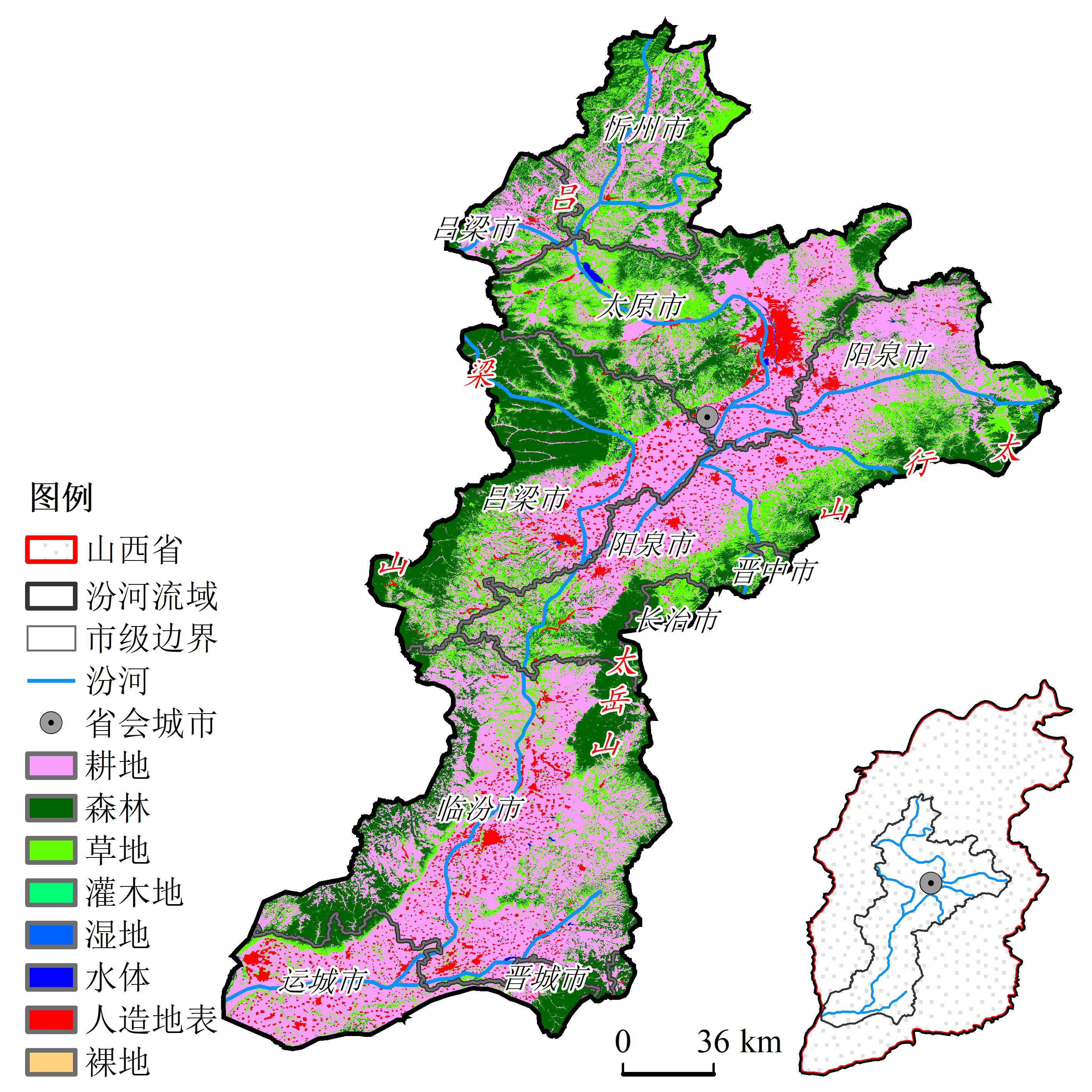
Figure 1 Distribution of location and land cover type in Fenhe River Basin
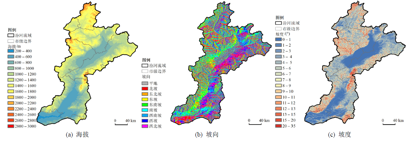
Figure 2 Spatial distribution of elevation, aspect and slope in Fenhe River Basin
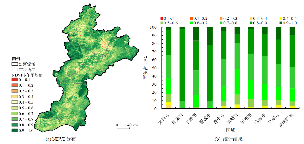
Figure 3 Spatial distribution and interannual variation of annual maximum NDVI in Fenhe River Basin from 2000 to 2021
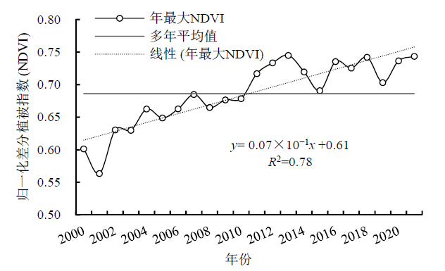
Figure 4 Annual NDVI change of vegetation in Fenhe River Basin from 2000 to 2021
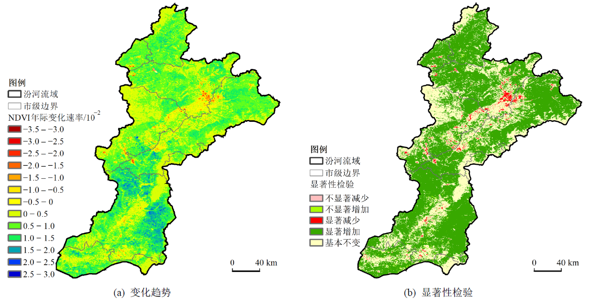
Figure 5 Variation trend and significance test of annual maximum NDVIin Fenhe River basin from 2000 to 2021
| 区域 | 平均年际变化速率/ (10-2∙a-1) | 面积比例/% | ||||
|---|---|---|---|---|---|---|
| 基本 不变 | 显著 增加 | 显著 减少 | 不显著 增加 | 不显著 减少 | ||
| 太原市 | 0.57 | 34.37 | 61.26 | 3.24 | 0.55 | 0.58 |
| 阳泉市 | 0.43 | 64.48 | 35.32 | 0.00 | 0.00 | 0.20 |
| 长治市 | 0.46 | 61.75 | 37.87 | 0.16 | 0.23 | 0.00 |
| 晋城市 | 0.58 | 42.72 | 57.13 | 0.05 | 0.10 | 0.00 |
| 晋中市 | 0.66 | 31.55 | 65.60 | 1.42 | 1.01 | 0.42 |
| 运城市 | 0.65 | 38.64 | 56.80 | 0.63 | 3.66 | 0.27 |
| 忻州市 | 0.73 | 26.78 | 72.39 | 0.12 | 0.63 | 0.08 |
| 临汾市 | 0.86 | 26.95 | 70.56 | 0.55 | 1.78 | 0.16 |
| 吕梁市 | 0.53 | 44.61 | 52.24 | 1.83 | 0.66 | 0.67 |
| 汾河流域 | 0.61 | 33.78 | 63.24 | 1.38 | 1.21 | 0.38 |
Table 1 NDVI change trend and significance test statistics of vegetation in Fenhe River basin from 2000 to 2021
| 区域 | 平均年际变化速率/ (10-2∙a-1) | 面积比例/% | ||||
|---|---|---|---|---|---|---|
| 基本 不变 | 显著 增加 | 显著 减少 | 不显著 增加 | 不显著 减少 | ||
| 太原市 | 0.57 | 34.37 | 61.26 | 3.24 | 0.55 | 0.58 |
| 阳泉市 | 0.43 | 64.48 | 35.32 | 0.00 | 0.00 | 0.20 |
| 长治市 | 0.46 | 61.75 | 37.87 | 0.16 | 0.23 | 0.00 |
| 晋城市 | 0.58 | 42.72 | 57.13 | 0.05 | 0.10 | 0.00 |
| 晋中市 | 0.66 | 31.55 | 65.60 | 1.42 | 1.01 | 0.42 |
| 运城市 | 0.65 | 38.64 | 56.80 | 0.63 | 3.66 | 0.27 |
| 忻州市 | 0.73 | 26.78 | 72.39 | 0.12 | 0.63 | 0.08 |
| 临汾市 | 0.86 | 26.95 | 70.56 | 0.55 | 1.78 | 0.16 |
| 吕梁市 | 0.53 | 44.61 | 52.24 | 1.83 | 0.66 | 0.67 |
| 汾河流域 | 0.61 | 33.78 | 63.24 | 1.38 | 1.21 | 0.38 |
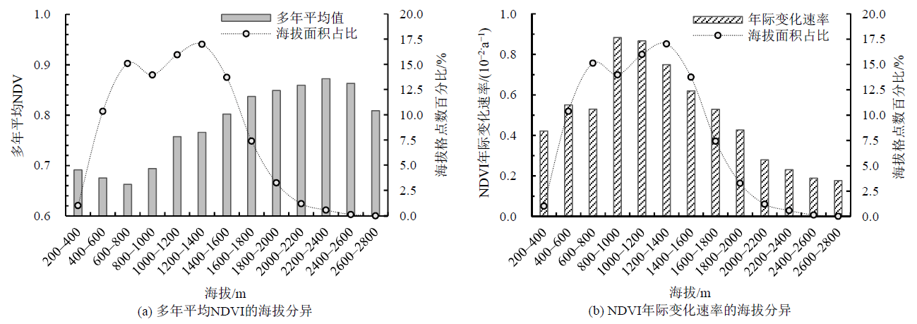
Figure 6 Elevation differences in the multi-year average NDVI and NDVI interannual rates of change in Fenhe River Basin
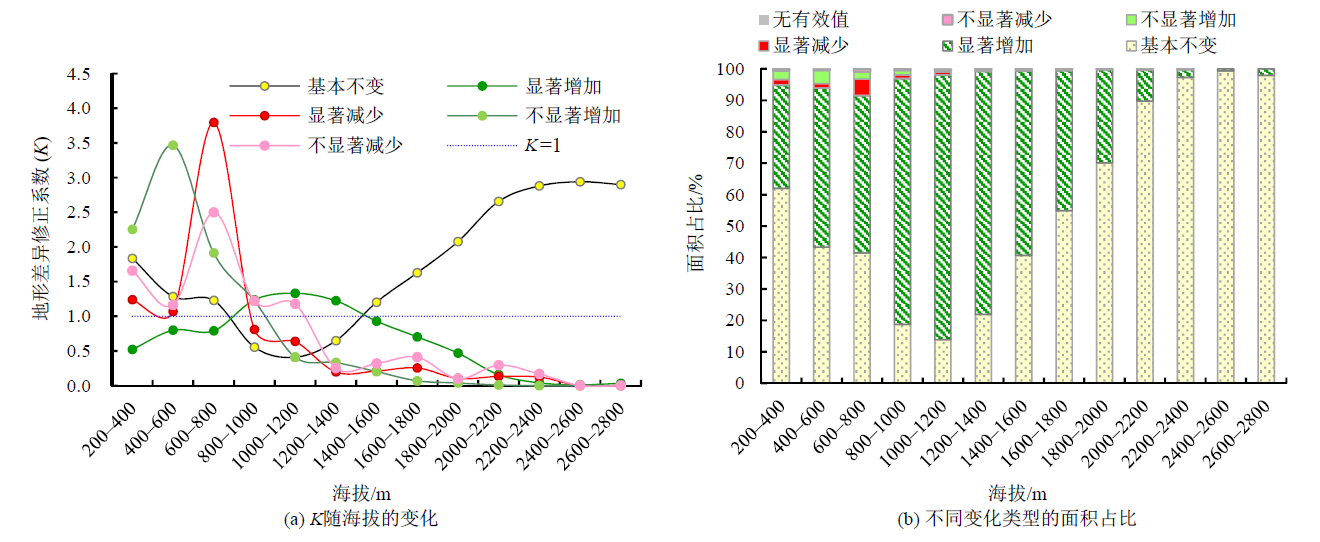
Figure 7 Changes of different vegetation types K with altitude and area proportion in Fenhe River Basin
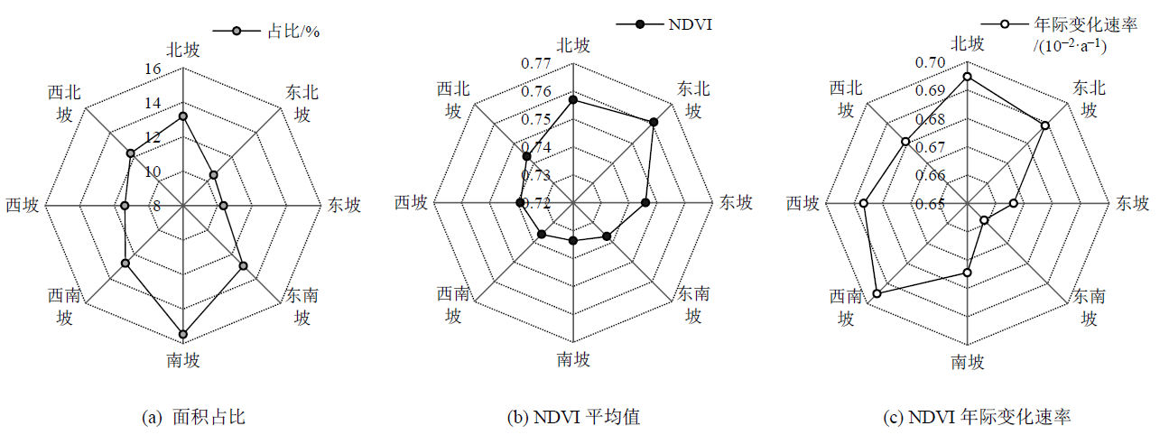
Figure 8 Aspect differences in the multi-year average NDVI and NDVI interannual rates of change in Fenhe River Basin
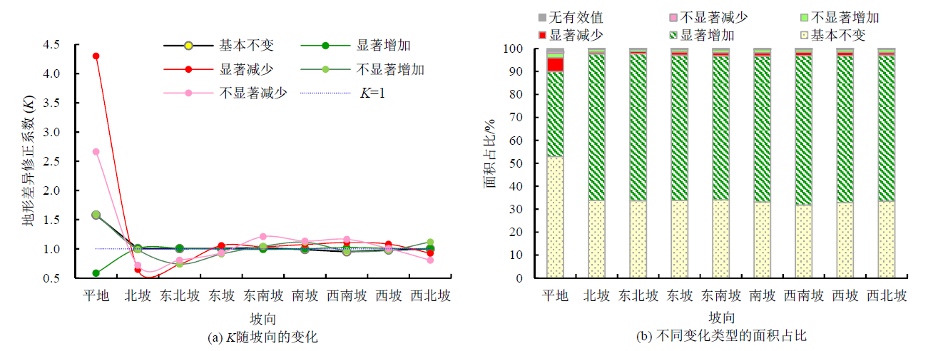
Figure 9 Changes of different vegetation types K with aspect and area proportion in Fenhe River Basin
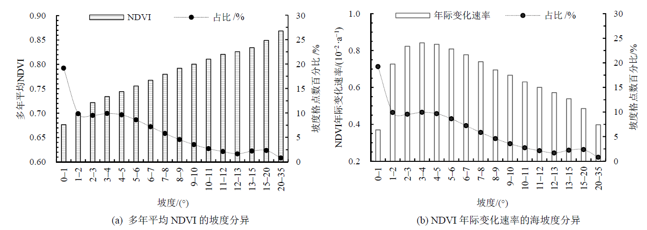
Figure 10 Slope differences in the iver Basin
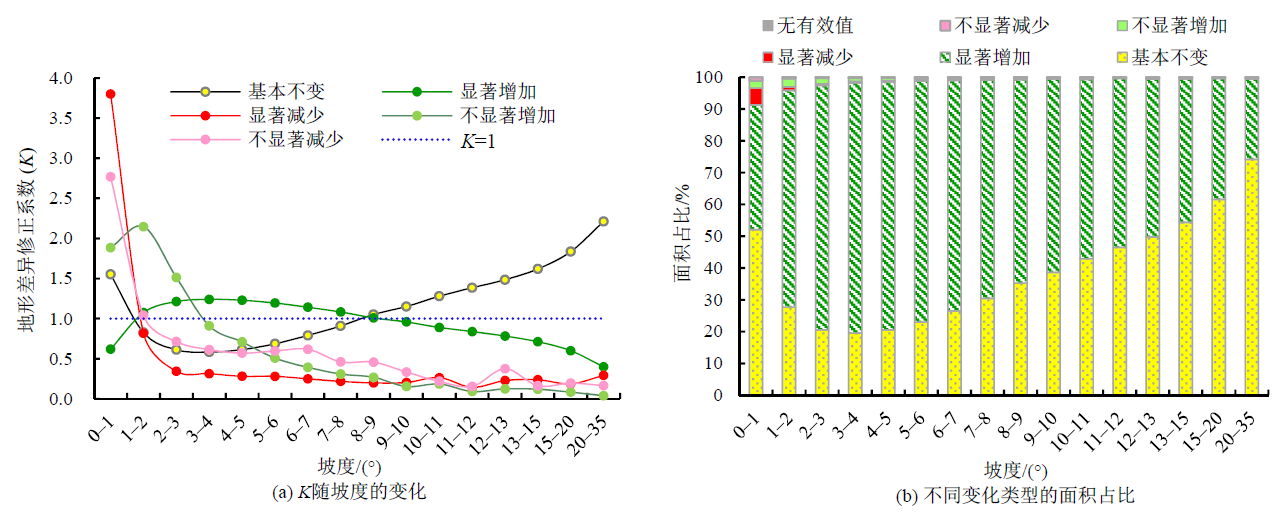
Figure 11 Changes of different vegetation types K with slope and area proportion in Fenhe River Basin
| [1] |
AFUYE G A, KALUMBA A M, ORIMOLOYE I R, 2021. Characterisation of vegetation response to climate change: A Review[J]. Sustainability, 13(13): 7265-7287.
DOI URL |
| [2] |
CALLIE B L, LYNN M R, YANG S, et al., 2020. Vegetation change as related to terrain factors at two glacier forefronts, Glacier National Park, Montana, U.S.A[J]. Journal of Mountain Science, 17(4): 1-15.
DOI |
| [3] |
CONG N, WANG T, NAN H J, et al., 2013. Changes in satellite-derived spring vegetation green-up date and its linkage to climate in China from 1982 to 2010: A Multimethod Analysis[J]. Global Change Biology, 19(3): 881-891.
DOI PMID |
| [4] |
LI H, ZHANG H Y, LI Q X, et al., 2021. Vegetation productivity dynamics in response to climate change and human activities under different topography and land cover in northeast China[J]. Remote Sensing, 13(5): 975.
DOI URL |
| [5] |
PARMESAN C, YOHE G, 2003. A globally coherent fingerprint of climate change impacts across natural systems[J]. Nature, 421(6918): 37-42.
DOI |
| [6] |
WU M M, HE H S, ZONG S W, et al., 2018. Topographic controls on vegetation changes in alpine tundra of the Changbai Mountains[J]. Forests, 9(12): 1-13.
DOI URL |
| [7] | 白建伟, 2019. 汾河流域近17年植被覆盖度时空特征变化研究[D]. 太原: 山西农业大学: 1-43. |
| BAI J W, 2019. Study on the temporal and spatial characteristics of vegetation coverage in the Fenhe River Basin in the past 17 years[D]. Taiyuan: Shanxi Agricultural University: 1-43. | |
| [8] | 白玛曲西, 普布多吉, 卓永, 等, 2022. 基于MODIS的横断山区植被时空演变特征及地形效应分析[J]. 生态与农村环境学报, 39(1): 1-16. |
| BAI M Q X, PU B D J, ZHUO Y, et al., 2022. Analysis of temporal and spatial evolution characteristics and terrain effect of vegetation in Hengduan Mountains based on MODIS[J]. Journal of Ecology and Rural Environment, 39(1): 1-16. | |
| [9] | 白鹏, 刘小莽, 2022. 汾河流域径流减少因素的定量解析[J]. 南水北调与水利科技, 20(5): 842-850. |
| BAI P, LIU X M, 2022. Quantitative analysis of runoff reduction factors in the Fenhe River Basin[J]. South-to-North Water Transfers and Water Science & Technology, 20(5): 842-850. | |
| [10] |
曹晓云, 祝存兄, 陈国茜, 等, 2022. 2000-2021年柴达木盆地地表绿度变化及地形分异研究[J]. 生态环境学报, 31(6): 1080-1090.
DOI |
| CAO X Y, ZHU C X, CHEN G Q, et al., 2022. Surface greenness change and topographic differentiation over Qaidam Basin from 2000 to 2021[J]. Ecology and Environment Sciences, 31(6): 1080-1090. | |
| [11] | 黄嘉佑, 李庆祥, 2015. 气象数据统计分析方法[M]. 北京: 气象出版社: 1-298. |
| HUANG J Y, LI Q X, 2015. Methods for statistical analysis of meteorological data[M]. Beijing: Meteorological Press: 1-298. | |
| [12] | 林菲, 池泽龙, 杨伟, 等, 2022. 1980-2020年汾河流域生态系统服务价值的时空变化[J]. 水土保持通报, 42(2): 322-329. |
| LIN F, CHI Z L, YANG W, et al., 2022. Spatial and temporal changes of ecosystem service value in Fenhe River Basin from 1980 to 2020[J]. Bulletin of Soil and Water Conservation, 42(2): 322-329. | |
| [13] | 刘海龙, 王炜桥, 王跃飞, 等, 2021. 汾河流域生态敏感性综合评价及时空演变特征[J]. 生态学报, 41(10): 3952-3964. |
| LIU H L, WANG W Q, WANG Y F, et al., 2021. Comprehensive evaluation of ecological sensitivity and the characteristics of spatiotemporal variations in Fenhe River Basin[J]. Acta Ecologica Sinica, 41(10): 3952-3964. | |
| [14] |
马士彬, 安裕伦, 杨广斌, 等, 2019. 不同地形梯度上的植被变化趋势及原因分析[J]. 生态环境学报, 28(5): 857-864.
DOI |
| MA S B, AN Y L, YANG G B, et al., 2019. The analysis of distribution characteristics and reasons of NDVI change trends along the terrain gradient[J]. Ecology and Environment Sciences, 28(5): 857-864. | |
| [15] | 苏迎庆, 张恩月, 刘源, 等, 2022. 汾河流域土地利用变化及生态环境效应[J]. 干旱区研究, 39(3): 968-977. |
| SU Y Q, ZHANG E Y, LIU Y, et al., 2022. Land-use change and ecological environment effects on Fenhe River Basin[J]. Arid Zone Research, 39(3): 968-977. | |
| [16] | 田惠文, 毕如田, 朱洪芬, 等, 2019. 汾河流域植被净初级生产力的驱动因素及梯度效应[J]. 生态学杂志, 38(10): 3066-3074. |
| TIAN H W, BI R T, ZHU H F, et al., 2019. Driving factors and gradient effect of net primary productivity in Fenhe River Basin[J]. Chinese Journal of Ecology, 38(10): 3066-3074. | |
| [17] | 童晓伟, 王克林, 岳跃民, 等, 2014. 桂西北喀斯特区域植被变化趋势及其对气候和地形的响应[J]. 生态学报, 34(12): 3425-3434. |
| TONG X W, WANG K L, YUE Y M, et al., 2014. Trends in vegetation and their responses to climate and topography in northwest Guangxi[J]. Acta Ecologica Sinica, 34(12): 3425-3434. | |
| [18] |
王瑞杰, 闫峰, 2020. 2000-2018年西北砒砂岩区植被覆盖度与地形效应[J]. 应用生态学报, 31(4): 1194-1202.
DOI |
| WANG R J, YAN F, 2020. Fractional vegetation cover and topographic effects in Pisha sandstone area of Northwest China in 2000-2018[J]. Chinese Journal of Applied Ecology, 31(4):1194-1202. | |
| [19] | 张会霞, 李永梅, 张娜, 2022. 汾河流域植被覆盖度时空特征与地形因子的关系[J]. 水土保持通报, 42(1):353-359. |
| ZHANG H X, LI Y M, ZHANG N, 2022. Relationship between temporal and spatial characteristics of vegetation coverage and topographic factors in Fenhe River Basin[J]. Bulletin of Soil and Water Conservation, 42(1):353-359. | |
| [20] | 赵婷, 白红英, 邓晨晖, 等, 2019. 2000-2016年秦岭山地植被覆盖变化地形分异效应[J]. 生态学报, 39(12): 4499-4509. |
| ZHAO T, BAI H Y, DENG C H, et al., 2019. Topographic differentiation effect on vegetation cover in the Qinling Mountains from 2000 to 2016[J]. Acta Ecologica Sinica, 39(12): 4499-4509. | |
| [21] |
朱林富, 谢世友, 杨华, 等, 2017. 基于MODIS EVI的重庆植被覆盖变化的地形效应[J]. 自然资源学报, 32(12): 2023-2033.
DOI |
| ZHU L F, XIE S Y, YANG H, et al., 2017. The response of dynamic change in vegetation coverage to topography in Chongqing based on MODIS EVI[J]. Journal of Natural Resources, 32(12): 2023-2033. | |
| [22] | 杜琦, 2018. 山西省汾河流域植被恢复对蒸散发的影响[J]. 人民珠江, 39(1): 10-12. |
| DU Q, 2018. Effects of vegetation restoration on evapotranspiration in Fenhe River Basin of Shanxi province[J]. Pearl River, 39(1): 10-12. | |
| [23] | 韩丽君, 李晶, 2017. 近10年汾河流域植被覆盖时空变化研究[J]. 山东农业大学学报(自然科学版), 48(6): 824-831. |
| HAN L J, LI J, 2017. Temporal and spatial variations of vegetational coverage in Fenhe River Basin during 10 Years[J]. Journal of Shandong Agricultural University (Natural Science Edition), 48(6): 824-831. | |
| [24] | 林兴贵, 2020. 汾河流域生态环境存在问题及生态修复总体思路探析[J]. 水利规划与设计(6): 32-34. |
| LIN X G, 2020. Analysis of the existing problems of the ecological environment in the Fenhe River Basin and the overall ideas of ecological restoration[J]. Water Resources Planning and Design (6): 32-34. | |
| [25] |
刘梁美子, 占车生, 胡实, 等, 2018. 黔桂喀斯特山区植被变化及其地形效应[J]. 地理研究, 37(12): 2433-2446.
DOI |
|
LIU L M Z, ZHAN C S, HU S, et al., 2018. Vegetation change and its topographic effects in the karst mountainous areas of Guizhou and Guangxi[J]. Geographical Research, 37(12): 2433-2446.
DOI |
|
| [26] |
潘霞, 汪季, 高永, 等, 2019. 基于MODIS数据的阿拉善盟植被指数变化的地形分异性[J]. 生态环境学报, 28(2): 226-234.
DOI |
| PAN X, WANG J, GAO Y, et al., 2019. Research on topographic differentiation of vegetation index based on MODIS in Alxa League[J]. Ecology and Environment Sciences, 28(2): 226-234. | |
| [27] | 王鹏, 魏信, 乔玉良, 2011. 多尺度下汾河流域生态环境质量评价与时序分析[J]. 遥感技术与应用, 26(6): 798-807. |
| WANG P, WEI X, QIAO Y L, 2011. Quality evaluation and time sequential analysis of eco-environment at multi-scales in Fen River Basin[J]. Remote Sensing Technology and Application, 26(6): 798-807. | |
| [28] | 王宇琛, 李松鸣, 王霄, 等, 2016. 汾河流域2001—2013年植被覆盖时空变化及其对气候因子的响应[J]. 山西农业科学, 44(5): 640-645. |
| WANG Y C, LI S M, WANG X, et al., 2016. Spatial and temporal dynamics of vegetation cover from 2001 to 2013 and its response to climatic[J]. Journal of Shanxi Agricultural Sciences, 44(5): 640-645. | |
| [29] | 银朵朵, 王艳慧, 2021. 温带大陆性半干旱季风气候区植被覆盖度时空变化及其地形分异研究[J]. 生态学报, 41(3): 1158-1167. |
| YIN D D, WANG Y H, 2021. Temporal and spatial changes of vegetation coverage and its topographic differentiation in temperate continental semi-arid monsoon climate region[J]. Acta Ecologica Sinica, 41(3): 1158-1167. | |
| [30] | 张衡, 马义娟, 李乐乐, 等, 2022. 汾河流域植被NDVI的时空变化特征及其对气候因子的响应[J]. 海南师范大学学报(自然科学版), 35(3): 322-332. |
| ZHANG H, MA Y J, LI L L, et al., 2022. Spatial-temporal change characteristics of vegetation NDVI and response to climate factors in the Fenhe River Basin[J]. Journal of Hainan Normal University (Natural Science), 35(3): 322-332. | |
| [31] |
朱小聪, 2022. 汾河流域植被生产力时空变异特征分析[J]. 中国农学通报, 38(5): 86-93.
DOI |
|
ZHU X C, 2022. Spatial and temporal variation characteristics of vegetation productivity in Fen River Basin[J]. Chinese Agricultural Science Bulletin, 38(5): 86-93.
DOI |
| [1] | WANG Xuemei, YANG Xuefeng, ZHAO Feng, AN Baisong, HUANG Xiaoyu. Estimation of Aboveground Biomass in the Arid Oasis Based on the Machine Learning Algorithm [J]. Ecology and Environment, 2023, 32(6): 1007-1015. |
| [2] | HAO Lei, ZHAI Yongguang, QI Wenchao, LAN Qiongqiong. Spatial-temporal Dynamics of Vegetation Carbon Sources/sinks in Inner Mongolia from 2001 to 2020 and Its Response to Climate Change [J]. Ecology and Environment, 2023, 32(5): 825-834. |
| [3] | WU Chenyu, XU Fanfan, WEI Shibo, FAN Jingjing, LIU Guanpeng, WANG Kun. Study on Response of Surface Vegetation Cover to Climate Change in Weihe River Basin [J]. Ecology and Environment, 2023, 32(5): 835-844. |
| [4] | CHEN Junfang, WU Xian, LIU Xiaolin, LIU Juan, YANG Jiarong, LIU Yu. Shaping Characteristics of Elemental Stoichiometry on Microbial Diversity under Different Soil Water Contents [J]. Ecology and Environment, 2023, 32(5): 898-909. |
| [5] | WANG Jiali, FENG Jingke, YANG Yuanzheng, ZU Jiaxing, CAI Wenhua, YANG Jian. Research on Spatial Relations between Impervious Surfaces and the Urban Thermal Environment in the Central Metropolitan Area of Nanning City [J]. Ecology and Environment, 2023, 32(3): 525-534. |
| [6] | ZHANG Shanwen, YANG Ran, HOU Wenxing, WANG Lili, LIU Shuang, SONG Hanyang, ZHAO Wenji, LI Lingjun. Analysis of Fractional Vegetation Cover Changes and Driving Forces on Both Banks of Yongding River Before and After Ecological Water Replenishment [J]. Ecology and Environment, 2023, 32(2): 264-273. |
| [7] | JIA Zhifeng, LIU Pengcheng, LIU Yu, WU Bobo, CHEN Danzi, ZHANG Xiangfei. Effects of Climatic Change and Human Activities on Vegetation Cover in Songliao River Basin [J]. Ecology and Environment, 2023, 32(1): 1-10. |
| [8] | ZHANG Lijin, DU Hu, ZENG Fuping, HUANG Guoqin, SONG Min, SONG Tongqing. Discussion on the Relationship between Productivity and Diversity during Vegetation Restoration in the Karst Peak-cluster Depression [J]. Ecology and Environment, 2023, 32(1): 26-35. |
| [9] | WU Shengyi, WANG Fei, XU Ganjun, MA Hao, DANG Yujie, WU Fei. Study on Forest Carbon Storage and Spatial Distribution in the Alpine Gorge Region of Northwest Sichuan: Take Sichuan Luoxu Nature Reserve as An Example [J]. Ecology and Environment, 2022, 31(9): 1735-1744. |
| [10] | QIN Yanpei, XU Shaojun, TIAN Yaowu. The Spatial Differentiation of Vegetation and Soil Carbon Density in Henan Section of the Yellow River Basin [J]. Ecology and Environment, 2022, 31(9): 1745-1753. |
| [11] | RUAN Huihua, XU Jianhui, ZHANG Feifei. Spatiotemporal Changes of Vegetation and Land Surface Temperature during 2001 and 2020 in the Guangdong-Hong Kong-Macao Greater Bay Area of China [J]. Ecology and Environment, 2022, 31(8): 1510-1520. |
| [12] | QI Yue, ZHANG Qiang, HU Shujuan, CAI Dihua, ZHAO Funian, ZHANG Kai, WANG Heling, WANG Runyuan. Climate Change and Its Impact on Winter Wheat Potential Productivity of Loess Plateau in China [J]. Ecology and Environment, 2022, 31(8): 1521-1529. |
| [13] | DENG Tianle, XIE Liyong, ZHANG Fengzhe, ZHAO Hongliang, JIANG Yutong. Competition for Growth Space between Barnyard Grass and Rice under Elevated Atmospheric CO2 Concentration [J]. Ecology and Environment, 2022, 31(8): 1566-1572. |
| [14] | LU Yanyu, SUN Wei, FANG Yanqiu, TANG Weian, DENG Hanqing, HE Dongyan. Estimating the Climatic Potential Productivity and the Climatic Capacity of Food Security Based on the Cropping Structure in Anhui Province [J]. Ecology and Environment, 2022, 31(7): 1293-1305. |
| [15] | CHEN Wenyu, XIA Lihua, XU Guoliang, YU Shiqin, CHEN Hang, CHEN Jinfeng. Dynamic Variation of NDVI and Its Influencing Factors in the Pearl River Basin from 2000 to 2020 [J]. Ecology and Environment, 2022, 31(7): 1306-1316. |
| Viewed | ||||||
|
Full text |
|
|||||
|
Abstract |
|
|||||
Copyright © 2021 Editorial Office of ACTA PETROLEI SINICA
Address:No. 6 Liupukang Street, Xicheng District, Beijing, P.R.China, 510650
Tel: 86-010-62067128, 86-010-62067137, 86-010-62067139
Fax: 86-10-62067130
Email: syxb@cnpc.com.cn
Support byBeijing Magtech Co.ltd, E-mail:support@magtech.com.cn