Ecology and Environmental Sciences ›› 2026, Vol. 35 ›› Issue (2): 167-177.DOI: 10.16258/j.cnki.1674-5906.2026.02.001
• Research Article [Ecology] • Next Articles
TAN Jie( ), WANG Qiong, LIAO Zhaoyang, DENG Huiting, ZHANG Yu, FAN Siyu, LI Xigui()
Received:2025-05-22
Revised:2025-10-02
Accepted:2025-10-28
Online:2026-02-18
Published:2026-02-09
Contact:
LI Xigui
谭洁(), 王琼, 廖朝阳, 邓慧婷, 张宇, 范思毓, 李细归()
通讯作者:
李细归
作者简介:谭洁(1979年生),女,副教授,博士,主要研究方向为土地利用与景观生态规划。E-mail: tanjie1225@hunau.edu.cn
基金资助:CLC Number:
TAN Jie, WANG Qiong, LIAO Zhaoyang, DENG Huiting, ZHANG Yu, FAN Siyu, LI Xigui. Multi-scale Identification and Zoning Regulation of Ecological Space in the Dongting Lake Ecological Economic Zone under Carbon Sequestration Goals[J]. Ecology and Environmental Sciences, 2026, 35(2): 167-177.
谭洁, 王琼, 廖朝阳, 邓慧婷, 张宇, 范思毓, 李细归. 碳增汇目标下洞庭湖生态经济区生态空间多尺度识别与分区管控[J]. 生态环境学报, 2026, 35(2): 167-177.
Add to citation manager EndNote|Ris|BibTeX
URL: https://www.jeesci.com/EN/10.16258/j.cnki.1674-5906.2026.02.001

Figure 1 Location of the studied area
| 数据类型 | 数据 | 分辨率 | 数据来源 | 年份 |
|---|---|---|---|---|
| 自然数据 | DEM | 30 m | ASTER GDEM V3( | 2019 |
| 降水 | 1 km | 地球资源数据云( | 2002, 2012, 2022 | |
| 气温 | 1 km | 地球资源数据云( | 2002, 2012, 2022 | |
| NDVI | 30 m | 国家生态数据中心( | 2002, 2012, 2022 | |
| CHEQ | 500 m | 国家地球系统科学数据中心( | 2002, 2012, 2021 | |
| 社会经济数据 | 人口分布 | 1 km | LandScan数据集( | 2002, 2012, 2022 |
| 夜间灯光 | 1 km | 地球资源数据云( | 2002, 2012, 2022 | |
| 交通网络密度 | - | OpenStreetsMap( | 2000, 2015, 2023 | |
| GDP | - | 地球资源数据云( | 2002, 2012, 2022 |
Table 1 Data sources
| 数据类型 | 数据 | 分辨率 | 数据来源 | 年份 |
|---|---|---|---|---|
| 自然数据 | DEM | 30 m | ASTER GDEM V3( | 2019 |
| 降水 | 1 km | 地球资源数据云( | 2002, 2012, 2022 | |
| 气温 | 1 km | 地球资源数据云( | 2002, 2012, 2022 | |
| NDVI | 30 m | 国家生态数据中心( | 2002, 2012, 2022 | |
| CHEQ | 500 m | 国家地球系统科学数据中心( | 2002, 2012, 2021 | |
| 社会经济数据 | 人口分布 | 1 km | LandScan数据集( | 2002, 2012, 2022 |
| 夜间灯光 | 1 km | 地球资源数据云( | 2002, 2012, 2022 | |
| 交通网络密度 | - | OpenStreetsMap( | 2000, 2015, 2023 | |
| GDP | - | 地球资源数据云( | 2002, 2012, 2022 |
| 土地利用类型 | 碳库类型 | 碳密度/(Mg∙hm−2) | ||
|---|---|---|---|---|
| 2002年 | 2012年 | 2022年 | ||
| 耕地 | 地上生物量 | 2.23 | 2.03 | 1.10 |
| 地下生物量 | 0.43 | 0.39 | 0.21 | |
| 死亡有机质 | 0.00 | 0.00 | 0.00 | |
| 土壤有机质 | 50.85 | 59.22 | 59.09 | |
| 林地 | 地上生物量 | 38.26 | 31.04 | 16.61 |
| 地下生物量 | 10.33 | 8.38 | 4.48 | |
| 死亡有机质 | 1.62 | 1.32 | 0.71 | |
| 土壤有机质 | 105.22 | 108.97 | 106.93 | |
| 草地 | 地上生物量 | 1.71 | 1.30 | 0.73 |
| 地下生物量 | 3.43 | 2.59 | 1.45 | |
| 死亡有机质 | 1.62 | 1.32 | 0.71 | |
| 土壤有机质 | 61.46 | 59.26 | 61.03 | |
| 水体与湿地 | 地上生物量 | 13.79 | 10.32 | 5.21 |
| 地下生物量 | 3.17 | 2.37 | 1.19 | |
| 死亡有机质 | 1.54 | 1.15 | 0.58 | |
| 土壤有机质 | 143.39 | 137.01 | 126.64 | |
| 未利用地 | 地上生物量 | 0.00 | 0.00 | 0.00 |
| 地下生物量 | 0.00 | 0.00 | 0.00 | |
| 死亡有机质 | 0.00 | 0.00 | 0.00 | |
| 土壤有机质 | 32.32 | 31.30 | 29.32 | |
| 建设用地 | 地上生物量 | 0.00 | 0.00 | 0.00 |
| 地下生物量 | 0.00 | 0.00 | 0.00 | |
| 死亡有机质 | 0.00 | 0.00 | 0.00 | |
| 土壤有机质 | 36.43 | 40.04 | 42.48 | |
Table 2 Carbon density values in the study area from 2002 to 2022
| 土地利用类型 | 碳库类型 | 碳密度/(Mg∙hm−2) | ||
|---|---|---|---|---|
| 2002年 | 2012年 | 2022年 | ||
| 耕地 | 地上生物量 | 2.23 | 2.03 | 1.10 |
| 地下生物量 | 0.43 | 0.39 | 0.21 | |
| 死亡有机质 | 0.00 | 0.00 | 0.00 | |
| 土壤有机质 | 50.85 | 59.22 | 59.09 | |
| 林地 | 地上生物量 | 38.26 | 31.04 | 16.61 |
| 地下生物量 | 10.33 | 8.38 | 4.48 | |
| 死亡有机质 | 1.62 | 1.32 | 0.71 | |
| 土壤有机质 | 105.22 | 108.97 | 106.93 | |
| 草地 | 地上生物量 | 1.71 | 1.30 | 0.73 |
| 地下生物量 | 3.43 | 2.59 | 1.45 | |
| 死亡有机质 | 1.62 | 1.32 | 0.71 | |
| 土壤有机质 | 61.46 | 59.26 | 61.03 | |
| 水体与湿地 | 地上生物量 | 13.79 | 10.32 | 5.21 |
| 地下生物量 | 3.17 | 2.37 | 1.19 | |
| 死亡有机质 | 1.54 | 1.15 | 0.58 | |
| 土壤有机质 | 143.39 | 137.01 | 126.64 | |
| 未利用地 | 地上生物量 | 0.00 | 0.00 | 0.00 |
| 地下生物量 | 0.00 | 0.00 | 0.00 | |
| 死亡有机质 | 0.00 | 0.00 | 0.00 | |
| 土壤有机质 | 32.32 | 31.30 | 29.32 | |
| 建设用地 | 地上生物量 | 0.00 | 0.00 | 0.00 |
| 地下生物量 | 0.00 | 0.00 | 0.00 | |
| 死亡有机质 | 0.00 | 0.00 | 0.00 | |
| 土壤有机质 | 36.43 | 40.04 | 42.48 | |
| 判断依据 | 交互作用 |
|---|---|
| q(xi∩xj)<min[q(xi), q(xj)] | 非线性减弱 |
| min[q(xi), q(xj)]<q(xi∩xj)<max[q(xi), q(xj)] | 单因子非线性减弱 |
| q(xi∩xj)>max[q(xi), q(xj)] | 双因子增强 |
| q(xi∩xj)=q(xi)+q(xj) | 独立 |
| q(xi∩xj)<q(xi)+q(xj) | 非线性增强 |
Table 3 Types of geoprobe interactions
| 判断依据 | 交互作用 |
|---|---|
| q(xi∩xj)<min[q(xi), q(xj)] | 非线性减弱 |
| min[q(xi), q(xj)]<q(xi∩xj)<max[q(xi), q(xj)] | 单因子非线性减弱 |
| q(xi∩xj)>max[q(xi), q(xj)] | 双因子增强 |
| q(xi∩xj)=q(xi)+q(xj) | 独立 |
| q(xi∩xj)<q(xi)+q(xj) | 非线性增强 |
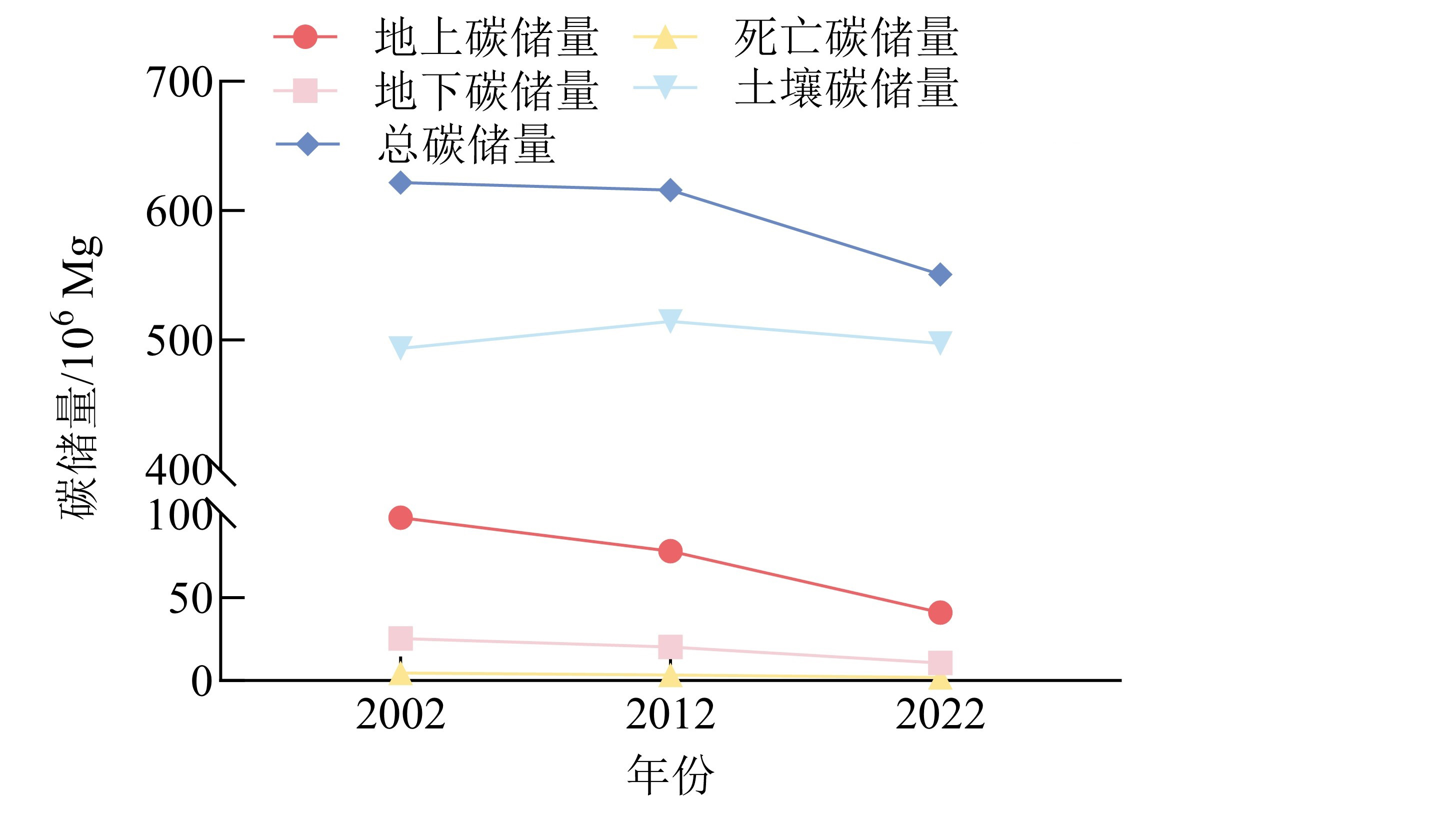
Figure 2 Carbon stocks based on carbon intensity type in Dongting Lake Ecological Economic Zone from 2002 to 2022

Figure 3 Spatial distribution of carbon stocks in Dongting Lake Ecological Economic Zone from 2002 to 2022

Figure 4 Changes in carbon stock differences in Dongting Lake Ecological Economic Zone from 2002 to 2022
| 类型 | 因子 | 分级 | 影响方向 | 权重 |
|---|---|---|---|---|
| 自然要素 | DEM 1) | 1-6 | 正 | 0.061 |
| 坡度 | 1-6 | 正 | 0.107 | |
| 地表起伏度 | 1-6 | 正 | 0.117 | |
| 降水 | 1-6 | 正 | 0.109 | |
| 气温 | 1-6 | 负 | 0.062 | |
| NDVI 2) | 1-6 | 正 | 0.061 | |
| CEHQ 3) | 1-6 | 正 | 0.096 | |
| 人工要素 | 人口分布 | 1-6 | 负 | 0.064 |
| 夜间灯光 | 1-6 | 负 | 0.064 | |
| 交通网络密度 | 1-6 | 负 | 0.040 | |
| GDP 4) | 1-6 | 负 | 0.067 | |
| 碳储量要素 | 碳储量 | 1-6 | 正 | 0.153 |
Table 4 Indicator weights for the ecospatial identification system
| 类型 | 因子 | 分级 | 影响方向 | 权重 |
|---|---|---|---|---|
| 自然要素 | DEM 1) | 1-6 | 正 | 0.061 |
| 坡度 | 1-6 | 正 | 0.107 | |
| 地表起伏度 | 1-6 | 正 | 0.117 | |
| 降水 | 1-6 | 正 | 0.109 | |
| 气温 | 1-6 | 负 | 0.062 | |
| NDVI 2) | 1-6 | 正 | 0.061 | |
| CEHQ 3) | 1-6 | 正 | 0.096 | |
| 人工要素 | 人口分布 | 1-6 | 负 | 0.064 |
| 夜间灯光 | 1-6 | 负 | 0.064 | |
| 交通网络密度 | 1-6 | 负 | 0.040 | |
| GDP 4) | 1-6 | 负 | 0.067 | |
| 碳储量要素 | 碳储量 | 1-6 | 正 | 0.153 |

Figure 5 Spatial and temporal changes in ecological space based on carbon stock from 2002 to 2022

Figure 6 County-level classification results from 2002 to 2022
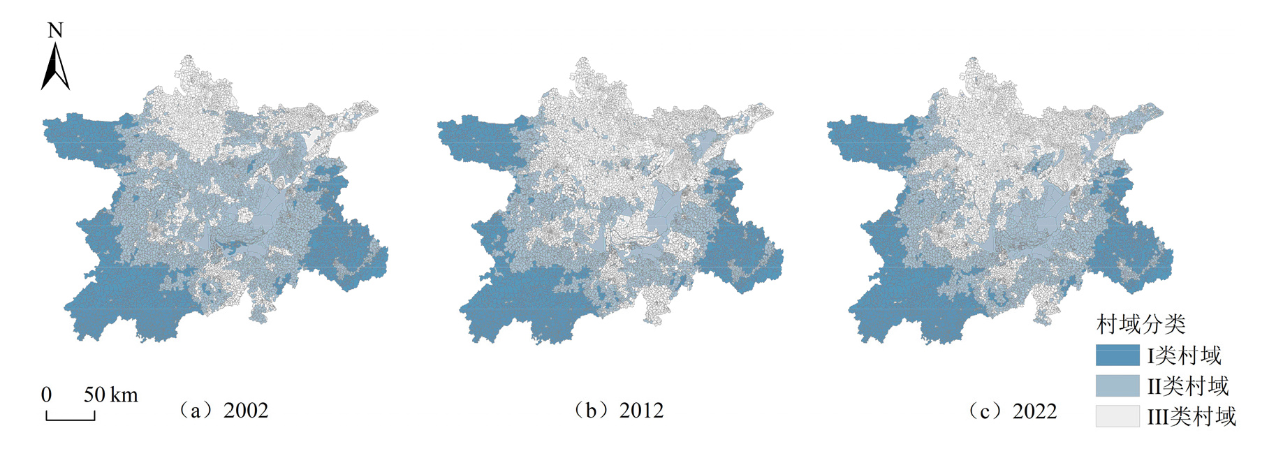
Figure 7 Village-level classification results from 2002 to 2022
| [1] |
ALAM S A, STARR M, CLARK B J F, 2017. Tree biomass and soil organic carbon densities across the Sudanese woodland savannah: A regional carbon sequestration study[J]. Journal of Arid Environments, 89(2): 67-76.
DOI URL |
| [2] | LI J F, LIU S Q, PENG B, et al., 2023. Identification and optimization of county-level ecological spaces under the Dual-carbon Target: A case study of Shaanxi Province, China[J]. Remote Sensing, 5(16): 4009. |
| [3] |
LI J F, ZHANG Y, XIA L F, et al., 2024. Research on zoning and carbon sink enhancement strategies for ecological spaces in counties with different landform types[J]. Sustainability, 16(13): 5700.
DOI URL |
| [4] |
LI J L, HU D W, WANG Y Z, et al., 2024. Study of identification and simulation of ecological zoning through integration of landscape ecological risk and ecosystem service value[J]. Sustainable Cities and Society, 107: 105442.
DOI URL |
| [5] | IPCC, 2021. Climate Change 2021: The Physical Science Basis: Working Group I Contribution to the Sixth Assessment Report of the Intergovernmental Panel on Climate Change[M]. Cambridge: Cambridge University Press. |
| [6] | SONG Y Z, WANG J F, GE Y, et al., 2020. An optimal parameters-based geographical detector model enhances geographic characteristics of explanatory variables for spatial heterogeneity analysis: Cases with different types of spatial data[J]. Geographical Information Science and Remote Sensing, 57(5): 593-610. |
| [7] |
XIANG W X, SANG S X, HAN S J, et al., 2025. Assessment of CO2 geological sequestration potential in the Northern Jiangsu-Southern Yellow Sea Basin via AHP-CRITIC methodology[J]. International Journal of Greenhouse Gas Control, 142: 104321.
DOI URL |
| [8] |
YANG J, HUANG X, 2021. The 30 m annual land cover dataset and its dynamics in China from 1990 to 2019[J]. Earth System Science Data, 13(8): 3907-3925.
DOI URL |
| [9] | 迟妍妍, 许开鹏, 王晶晶, 等, 2018. 京津冀地区生态空间识别研究[J]. 生态学报, 38(23): 8555-8563. |
| CHI Y Y, XU K P, WANG J J, et al., 2018. Identifying regional ecological space in Beijing, Tianjin, and Hebei[J]. Acta Ecologica Sinica, 38(23): 8555-8563. | |
| [10] | 褚加计, 张致远, 金中昊, 等, 2024. 河南省南太行地区生态空间识别及演化分析[J]. 安全与环境工程, 31(4): 280-286. |
| CHU J J, ZHANG Z Y, JIN Z H, et al., 2024. Identification and evolution analysis of ecological space in the South Taihang area of Henan Province[J]. Safety and Environmental Engineering, 31(4): 280-286. | |
| [11] | 戴菲, 江佩宜, 文晨, 2023. 基于生态系统服务簇分析的城市生态空间碳汇能力综合提升[J]. 风景园林, 30(11): 96-104. |
| DAI F, JIANG P Y, WEN C, 2023. Integrated enhancement of carbon sink capacity for urban ecological spaces based on ecosystem service cluster analysis[J]. Landscape Architecture, 30(11): 96-104. | |
| [12] | 方精云, 于贵瑞, 任小波, 等, 2015. 中国陆地生态系统固碳效应——中国科学院战略性先导科技专项 “应对气候变化的碳收支认证及相关问题” 之生态系统固碳任务群研究进展[J]. 中国科学院院刊, 30(6): 848-857, 875. |
| FANG J Y, YU G R, REN X B, et al., 2015. Carbon sequestration effects of China’s terrestrial ecosystems: Research progress of the CAS strategic priority program “Carbon Budget and Related Issues for Addressing Climate Change” [J]. Bulletin of Chinese Academy of Sciences, 30(6): 848-857, 875. | |
| [13] | 费建波, 夏建国, 胡佳, 等, 2019. 生态空间与生态用地国内研究进展[J]. 中国生态农业学报, 27(11): 1626-1636. |
| FEI J B, XIA J G, HU J, et al., 2019. Research progress of ecological space and ecological land in China[J]. Chinese Journal of Eco-Agriculture, 27(11): 1626-1636. | |
| [14] | 顾彤, 张青峰, 游政, 等, 2024. 基于“双评价”约束和PLUS模型的三重城镇开发边界划定[J]. 农业工程学报, 40(14): 210-220. |
| GU T, ZHANG Q F, YOU Z, et al., 2024. Delineating three urban growth boundaries using “Dual-Evaluation” constraints and PLUS Model[J]. Transactions of the Chinese Society of Agricultural Engineering, 40(14): 210-220. | |
| [15] | 李欣, 董智, 李小倩, 等, 2024. 鲁中南山地丘陵区多尺度下生态空间分区管控的探讨[J]. 干旱区资源与环境, 38(8): 129-138. |
| LI X, DONG Z, LI X Q, et al., 2024. A probe to the ecological space zoning control at multiple scales in hilly areas of central-south Shandong[J]. Resources and Environment in Arid Regions, 38(8): 129-138. | |
| [16] |
罗光浴, 王志远, 2024. 洞庭湖生态经济区国土空间格局演变的碳储量效应及驱动因素研究[J]. 生态环境学报, 33(11): 1672-1685.
DOI |
| LUO G Y, WANG Z Y, 2024. Research on the carbon storage effect and driving factors of the evolution of territorial space pattern in Dongting Lake Ecological and Economic Zone[J]. Ecology and Environmental Sciences, 33(11): 1672-1685. | |
| [17] | 吕一河, 傅伯杰, 2001. 生态学中的尺度及尺度转换方法[J]. 生态学报, 21(12): 2096-2105. |
| LÜ Y H, FU B J, 2001. Ecological scale and scaling[J]. Acta Ecologica Sinica, 21(12): 2096-2105. | |
| [18] | 任玺锦, 裴婷婷, 陈英, 等, 2021. 基于碳密度修正的甘肃省土地利用变化对碳储量的影响[J]. 生态科学, 40(4): 66-74. |
| REN X J, PEI T T, CHEN Y, et al., 2021. Impact of land use change on carbon storage in Gansu Province based on carbon density correction[J]. Ecological Science, 40(4): 66-74. | |
| [19] | 宋国恺, 2021. 中国落实碳达峰、碳中和目标的行动主体及实现措施[J]. 城市与环境研究 (4): 47-60. |
| SONG G K, 2021. Actors and implementation measures for achieving China’s carbon peak and carbon neutrality goals[J]. Urban and Environmental Studies (4): 47-60. | |
| [20] | 王智勇, 冯京昕, 黄亚平, 等, 2024. 特大城市都市区生态空间识别评价、网络构建与优化模型研究[J]. 中国园林, 40(11): 83-89. |
| WANG Z Y, FENG J X, HUANG Y P, et al., 2024. Research on ecological space identification, evaluation, network construction and optimization model of metropolitan areas[J]. Chinese Landscape Architecture, 40(11): 83-89. | |
| [21] | 王兆峰, 杨钊颖, 张海燕, 2023. 基于生态系统服务价值的洞庭湖生态经济区生态补偿标准与策略优化[J]. 湖南师范大学自然科学学报, 46(5): 63-71. |
| WANG Z F, YANG Z Y, ZHANG H Y, 2023. Ecological compensation standard and strategy optimization of Dongting Lake Ecological Economic Zone based on ecosystem service value[J]. Journal of Natural Science of Hunan Normal University, 46(5): 63-71. | |
| [22] |
吴倩莲, 李飞雪, 张启舜, 等, 2022. 基于网络分析的城市生态空间结构优化——以常州市为例[J]. 应用生态学报, 33(7): 1983-1992.
DOI |
| WU Q L, LI F X, ZHANG Q S, et al., 2022. Optimization of urban ecological spatial structure based on network analysis: A case study of Changzhou City, China[J]. Chinese Journal of Applied Ecology, 33(7): 1983-1992. | |
| [23] | 张赫, 贺晶, 杨兴源, 等, 2022. 碳增汇目标下县域生态空间的分区及管控策略——以京津冀地区县域为例[J]. 规划师, 38(1): 32-40. |
| ZHANG H, HE J, YANG X Y, et al., 2022. Zoning and governance of county ecological space for the increase of carbon sinks: A case study of the Beijing-Tianjin-Hebei Region[J]. Planners, 38(1): 32-40. | |
| [24] | 张亮, 岳文泽, 2019. 城市生态空间多元综合识别研究——以杭州市为例[J]. 生态学报, 39(17): 6460-6468. |
| ZHANG L, YUE W Z, 2019. Integrated recognition of urban ecological space: A case study on Hangzhou[J]. Acta Ecologica Sinica, 39(17): 6460-6468. | |
| [25] |
朱文博, 张静静, 崔耀平, 等, 2019. 基于土地利用变化情景的生态系统碳储量评估——以太行山淇河流域为例[J]. 地理学报, 74(3): 446-459.
DOI |
|
ZHU W B, ZHANG J J, CUI Y P, et al., 2019. Assessment of territorial ecosystem carbon storage based on land use change scenario: A case study in Qihe River Basin[J]. Acta Geographica Sinica, 74(3): 446-459.
DOI |
|
| [26] | 周文强, 韩宇, 王金龙, 等, 2024. 洞庭湖流域碳储量的时空异质性及驱动力分析[J]. 中国环境科学, 44(4): 1851-1862. |
| ZHOU W Q, HAN Y, WANG J L, et al., 2024. Spatiotemporal heterogeneity and driving forces of carbon storage in the Dongting Lake Basin[J]. China Environmental Science, 44(4): 1851-1862 |
| Viewed | ||||||
|
Full text |
|
|||||
|
Abstract |
|
|||||
Copyright © 2021 Editorial Office of ACTA PETROLEI SINICA
Address:No. 6 Liupukang Street, Xicheng District, Beijing, P.R.China, 510650
Tel: 86-010-62067128, 86-010-62067137, 86-010-62067139
Fax: 86-10-62067130
Email: syxb@cnpc.com.cn
Support byBeijing Magtech Co.ltd, E-mail:support@magtech.com.cn