
生态环境学报 ›› 2026, Vol. 35 ›› Issue (7): 1125-1135.DOI: 10.16258/j.cnki.1674-5906.2026.07.012
罗茜云1( ), 陈安强2, 付斌2, 胡万里2, 闫辉2, 倪明2, 王炽2,*(), 张丹1,*()
收稿日期:2025-10-25
修回日期:2026-01-19
接受日期:2026-02-13
出版日期:2026-07-18
发布日期:2026-07-17
通讯作者:
*王炽,yidan33@163.com;张丹,saiyuwang@163.com
作者简介:罗茜云(2002年生),女,硕士研究生,主要研究方向为农业面源污染监测与防控。E-mail: 1632329440@qq.com
基金资助:
Luo Xiyun1(), Chen Anqiang2, Fu Bin2, Hu Wanli2, Yan Hui2, Ni Ming2, Wang Chi2,*(), Zhang Dan1,*()
Received:2025-10-25
Revised:2026-01-19
Accepted:2026-02-13
Online:2026-07-18
Published:2026-07-17
摘要:
土地利用决定了高原湖泊流域污染物“源”的分布格局,而季节变化调控着污染物“汇”的关键驱动,二者通过源-汇过程主导着入湖河流的水质变化。以星云湖流域为研究对象,选取8条主要入湖河流上中下游共23个断面,结合30 m DEM、遥感影像解译与SWAT模型对8个子流域进行划分,系统分析了2018年雨、旱季8条河流水质浓度的时空变化特征及其与季节变化和土地利用的关系。结果表明,8条河流中COD、TN、NH4+-N、TP浓度以大街河和小街河最高,其次为旧州河、东大河、西大河、渔村河,而学河和螺蛳铺河最低。降雨和水温是影响河流水质季节变化的关键因子,降雨稀释和水温升高使河水中COD、TN、NH4+-N、TP浓度较旱季下降了39.4%、21.7%、47.7%、33.8%。河流中游段COD、TN、NH4+-N、TP浓度较上游和下游分别增加了30.3%和32.4%、38.1%和42.4%、72.4%和89.2%、37.5%和15.8%,是污染物主要源区。COD、氮磷浓度与流域内建设用地和耕地面积占比呈正相关,与林草地呈负相关。水质优劣与土地利用密切相关,以建设用地和耕地混合主导型的大街河和小街河水质最差,其次是耕地主导型的渔村河,而林草地主导型的螺蛳铺河和学河水质较好。高原湖泊流域面源污染治理需依据不同流域土地利用特点提出差异化治理对策。
中图分类号:
罗茜云, 陈安强, 付斌, 胡万里, 闫辉, 倪明, 王炽, 张丹. 星云湖流域主要入湖河流水质对土地利用和季节变化的响应[J]. 生态环境学报, 2026, 35(7): 1125-1135.
Luo Xiyun, Chen Anqiang, Fu Bin, Hu Wanli, Yan Hui, Ni Ming, Wang Chi, Zhang Dan. Response of Water Quality in Major Rivers Flowing into Lake to Land Use and Seasonal Variation in the Xingyun Lake Basin[J]. Ecology and Environmental Sciences, 2026, 35(7): 1125-1135.
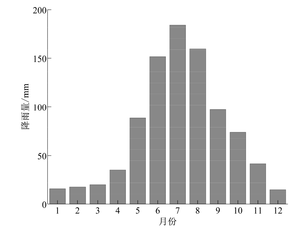
图1 2018年星云湖流域月降雨量
Figure 1 Monthly rainfall in the Xingyun Lake basin in 2018
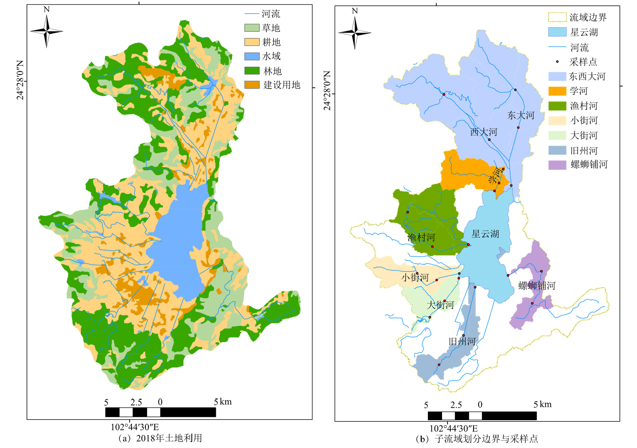
图2 星云湖流域土地利用和8条主要入湖河流子流域边界以及采样点
Figure 2 Land use in the Xingyun Lake basin and boundaries of the sub-basins of 8 major rivers flowing into lake, as well as sampling points
| 子流域 名称 | 子流域总面积/ km2 | 草地面积占比/ % | 耕地面积占比/ % | 水域面积占比/ % | 林地面积占比/ % | 建设用地面积占比/ % |
|---|---|---|---|---|---|---|
| 学河 | 17.2 | 34.0 | 30.7 | 9.93 | 19.6 | 5.73 |
| 渔村河 | 32.0 | 5.49 | 62.4 | 6.51 | 22.4 | 3.23 |
| 小街河 | 15.5 | 15.7 | 54.9 | 1.71 | 10.4 | 17.4 |
| 大街河 | 13.9 | 5.01 | 57.7 | 4.16 | 6.41 | 26.7 |
| 旧州河 | 16.8 | 13.0 | 33.6 | 0.09 | 44.6 | 8.81 |
| 螺蛳铺河 | 14.0 | 64.6 | 21.6 | 0.84 | 8.61 | 4.33 |
| 东西大河 | 106 | 16.8 | 37.8 | 1.99 | 36.5 | 6.84 |
| 星云湖流域 | 455 | 15.2 | 24.7 | 9.87 | 32.8 | 4.18 |
表1 星云湖流域和8条主要入湖河流子流域的土地利用类型面积和占比
Table1 Area and proportion of different land-use types in the Xingyun Lake basin and sub-basins of 8 major rivers flowing into lake
| 子流域 名称 | 子流域总面积/ km2 | 草地面积占比/ % | 耕地面积占比/ % | 水域面积占比/ % | 林地面积占比/ % | 建设用地面积占比/ % |
|---|---|---|---|---|---|---|
| 学河 | 17.2 | 34.0 | 30.7 | 9.93 | 19.6 | 5.73 |
| 渔村河 | 32.0 | 5.49 | 62.4 | 6.51 | 22.4 | 3.23 |
| 小街河 | 15.5 | 15.7 | 54.9 | 1.71 | 10.4 | 17.4 |
| 大街河 | 13.9 | 5.01 | 57.7 | 4.16 | 6.41 | 26.7 |
| 旧州河 | 16.8 | 13.0 | 33.6 | 0.09 | 44.6 | 8.81 |
| 螺蛳铺河 | 14.0 | 64.6 | 21.6 | 0.84 | 8.61 | 4.33 |
| 东西大河 | 106 | 16.8 | 37.8 | 1.99 | 36.5 | 6.84 |
| 星云湖流域 | 455 | 15.2 | 24.7 | 9.87 | 32.8 | 4.18 |

图3 8条主要入湖河流不同断面水质指标季节变化
Figure 3 Seasonal variations in water quality indicators at different cross-sections of the 8 major rivers flowing into lake

图4 各入湖河流控制断面水质指标差异
Figure 4 Differences in water quality indicators at the control sections of each river flowing into lake
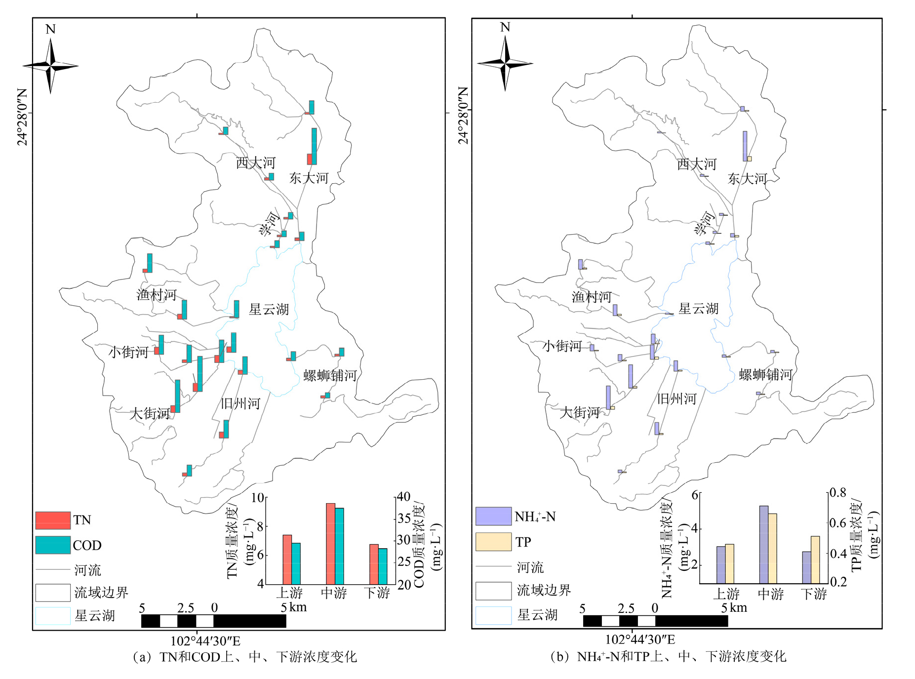
图5 星云湖主要入湖河流上、中、下游水质指标浓度变化
Figure 5 Concentration variations of water quality indicators in the upper, middle, and lower reaches of the major rivers flowing into Xingyun Lake
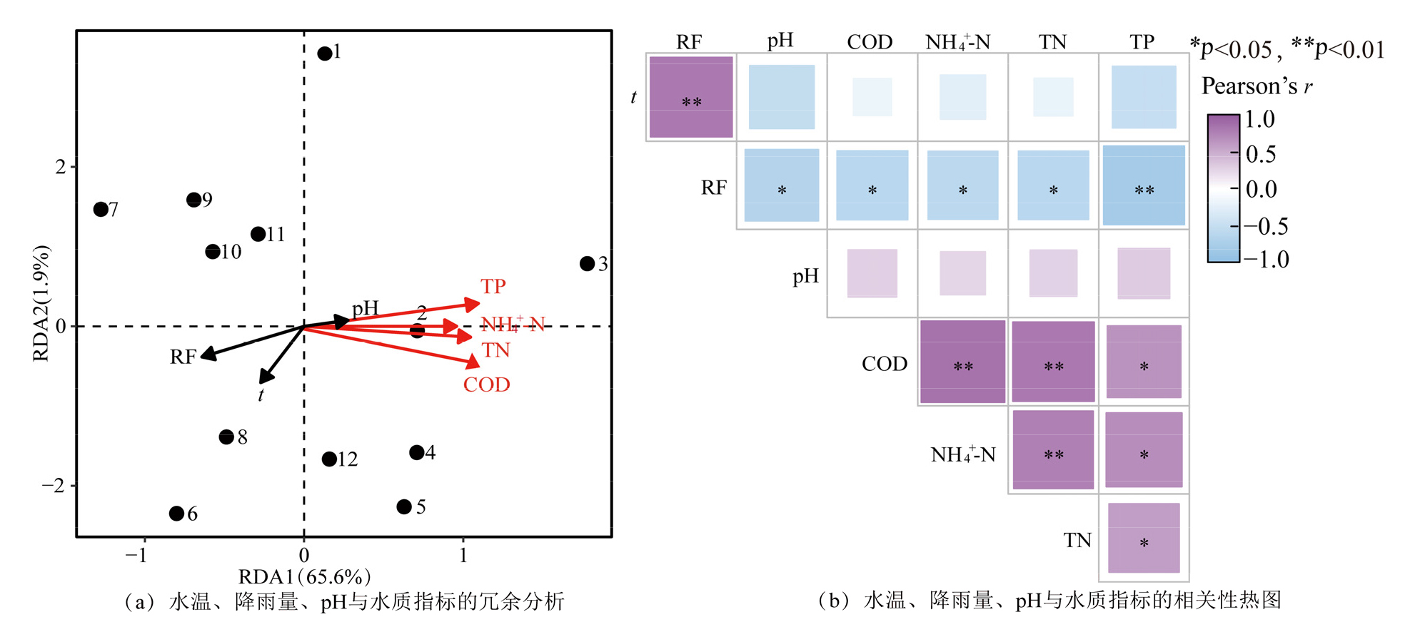
图6 水温、降雨量、pH与河流水质指标的冗余分析和相关性热图 1 -12为1-12月水质;RF为降雨量;t为水温;*和**分别表示在0.05和0.01水平上显著差异;红线为水质指标;黑线为环境因子
Figure 6 Redundancy analysis (RDA) and correlation heatmap of water temperature, rainfall, pH, and river water-quality indicators

图7 星云湖流域和四类典型子流域土地利用类型面积比与主要入湖河流水质指标的关系 C、G、S、L、J分别为草地、耕地、水域、林地、建设用地;*为在0.05水平差异显著,**为在0.01水平差异极显著
Figure 7 The relationship between the area ratio of land use types in the Xingyun Lake basin and four typical sub-basins, and the water quality indicators of the major rivers flowing into the lake
| [1] |
Chang F Q, Hou P F, Wen X Y, et al., 2022. Seasonal stratification characteristics of vertical profiles and water quality of Lake Lugu in Southwest China[J]. Water, 14(16): 2554.
DOI URL |
| [2] |
Luo L C, Zhang H C, Luo C L, et al., 2022. Tributary loadings and their impacts on water quality of Lake Xingyun, a plateau lake in Southwest China[J]. Water, 14(8): 1281.
DOI URL |
| [3] |
Liu M L, Tian H Q, Chen G S, et al., 2008. Effects of land-use and land-cover change on evapotranspiration and water yield in China during 1900-2000[J]. Journal of the American Water Resources Association, 44(5): 1193-1207.
DOI URL |
| [4] |
Xu B, Zhou T, Kuang C Y, et al., 2024. Water quality assessment in a large plateau lake in China from 2014 to 2021 with machine learning models: Implications for future water quality management[J]. The Science of the Total Environment, 946: 174212.
DOI URL |
| [5] | 白莹, 薛山, 鲁善海, 等, 2016. 沙颍河流域平原区土壤氮空间分布特征及影响因素研究[J]. 南京大学学报(自然科学), 52(1): 65-76. |
| Bai Y, Xue S, Lu S H, et al., 2016. Spatial distribution of soil nitrogen and its influencing factors in the plain area of the Shaying River basin[J]. Journal of Nanjing University (Natural Sciences), 52(1): 65-76. | |
| [6] | 丹宇卓, 彭建, 张子墨, 等, 2020. 基于 “退化压力-供给状态-修复潜力” 框架的国土空间生态修复分区——以珠江三角洲为例[J]. 生态学报, 40(23): 8451-8460. |
| Dan Y Z, Peng J, Zhang Z M, et al., 2020. Territorial-space ecological-restoration zoning based on the “degradation-pressure-supply-state-restoration-potential” framework: A case study of the Pearl River Delta[J]. Acta Ecologica Sinica, 40(23): 8451-8460. | |
| [7] | 杜泽兵, 阳文静, 向丽雄, 等, 2017. 湖泊水质影响因素研究综述[J]. 环境污染与防治, 39(3): 343. |
| Du Z B, Yang W J, Xiang L X, et al., 2017. Review of factors influencing lake water quality[J]. Environmental Pollution & Control, 39(3): 343. | |
| [8] | 付蕊, 刘沙沙, 索诚宇, 等, 2024. 2008-2022年我国湖泊有机质相关指标时空演变[J]. 中国环境科学, 44(3): 1426-1435. |
| Fu R, Liu S S, Suo C Y, et al., 2024. Spatio-temporal evolution of organic-matter-related indicators in Chinese lakes, 2008-2022[J]. China Environmental Science, 44(3): 1426-1435. | |
| [9] | 顾洋, 张平究, 秦风约, 等, 2024. 多时空景观格局对南淝河水质的影响[J]. 农业环境科学学报, 43(7): 1-14. |
| Gu Y, Zhang P J, Qin F Y, et al., 2024. Impacts of multi-temporal landscape patterns on water quality in the Nanfei River[J]. Journal of Agro-Environment Science, 43(7): 1-14. | |
| [10] | 国家环境保护总局科技标准司, 2002. 地表水环境质量标准: GB 3838—2002[S]. 北京: 中国标准出版社. |
| Department of Science & Technology Standards, SEPA, 2002. Environmental quality standards for surface water: GB 3838—2002[S]. Beijing: China Standards Press. | |
| [11] | 郭羽羽, 李思悦, 刘睿, 等, 2021. 黄河流域多时空尺度土地利用与水质的关系[J]. 湖泊科学, 33(3): 737-748. |
|
Guo Y Y, Li S Y, Liu R, et al., 2021. Relationships between land use and water quality at multiple spatiotemporal scales in the Yellow River Basin[J]. Journal of Lake Sciences, 33(3): 737-748.
DOI URL |
|
| [12] | 孔燕, 白晓华, 2019. 星云湖南岸主要入湖河流氮入湖污染特征及南岸调蓄系统削减效果研究[J]. 水文, 39(1): 60-65. |
| Kong Y, Bai X H, 2019. Nitrogen pollution characteristics of south-bank inflow rivers to Lake Xingyun and the mitigation efficiency of the south-bank regulation system[J]. Journal of China Hydrology, 39(1): 60-65. | |
| [13] | 李巍, 陈涵贞, 苏德森, 等, 2011. 闽江水域水质时空分布探索性研究[J]. 农业系统科学与综合研究, 27(4): 418-422. |
| Li W, Chen H Z, Su D S, et al., 2011. Exploratory study on spatiotemporal distribution of water quality in the Minjiang River basin[J]. System Science & Comprehensive Research in Agriculture, 27(4): 418-422. | |
| [14] | 李子晨, 陈俊旭, 易琦, 等, 2020. 抚仙湖、星云湖与杞麓湖营养状态演变及突变分析[J]. 中国环境监测, 36(3): 105-113. |
| Li Z C, Chen J X, Yi Q, et al., 2020. Evolution and abrupt change analysis of trophic status in Fuxian, Xingyun and Qilu lakes[J]. Environmental Monitoring in China, 36(3): 105-113. | |
| [15] | 李振, 彭毅, 汪驰恒, 等, 2025. 洞庭湖区小型湖泊水质状况空间特征及影响因素[J]. 环境科学与技术, 48(2): 152-160. |
| Li Z, Peng Y, Wang C H, et al., 2025. Spatial characteristics and influencing factors of water quality of small lakes in the Dongting Lake area[J]. Environmental Science & Technology, 48(2): 152-160. | |
| [16] | 梁旭, 刘华民, 纪美辰, 等, 2021. 北方半干旱区土地利用/覆被变化对湖泊水质的影响: 以岱海流域为例 (2002-2018年)[J]. 湖泊科学, 33(3): 727-738. |
|
Liang X, Liu H M, Ji M C, et al., 2021. Effects of land-use/land-cover change on lake water quality in a semi-arid region of northern China: A case study of the Daihai watershed (2002-2018) [J]. Journal of Lake Sciences, 33(3): 727-738.
DOI URL |
|
| [17] | 刘旭华, 刘华民, 于洪波, 等, 2025. 气候变化对干旱半干旱区湖泊水质的影响[J]. 环境科学与技术, 48(1): 41-48. |
| Liu X H, Liu H M, Yu H B, et al., 2025. Impact of climate change on lake water quality in arid and semi-arid regions[J]. Environmental Science & Technology, 48(1): 41-48. | |
| [18] | 罗玉, 肖尧, 张晓旭, 等, 2020. 抚仙湖-星云湖流域氮、磷污染防治对策研究——以2000-2015年数据为例[J]. 环境保护科学, 46(1):106-112, 161. |
| Luo Y, Xiao Y, Zhang X X, et al., 2020. Countermeasures for nitrogen and phosphorus pollution control in the Fuxian Lake Xingyun Lake Basin: A case study of data from 2000 to 2015[J]. Environmental Protection Science, 46(1): 106-112, 161. | |
| [19] | 祁兰兰, 王金亮, 叶辉, 等, 2021. 滇中 “三湖流域” 土地利用景观格局与水质变化关系研究[J]. 水土保持研究, 28(6): 199-208. |
| Qi L L, Wang J L, Ye H, et al., 2021. Relationship between land-use landscape pattern and water-quality change in the central-Yunnan “Three-Lake Basin”[J]. Research of Soil & Water Conservation, 28(6): 199-208. | |
| [20] | 任春坪, 郑丙辉, 2024. 高原湖泊水质变化趋势及驱动因素研究: 以四川邛海为例[J]. 湖泊科学, 36(3): 756-769. |
|
Ren C P, Zheng B H, 2024. Water-quality variation trends and driving factors of plateau lakes: A case study of Qionghai Lake, Sichuan[J]. Journal of Lake Sciences, 36(3): 756-769.
DOI URL |
|
| [21] | 谭志卫, 余艳红, 武孔焕, 等, 2021. 星云湖流域不同耕地轮作休耕情景对水质的影响及经济效益分析研究[J]. 环境污染与防治, 43(3): 400-404. |
| Tan Z W, Yu Y H, Wu K H, et al., 2021. Impacts of different crop-rotation and fallow scenarios on water quality and economic benefits in the Lake Xingyun basin[J]. Environmental Pollution & Control, 43(3): 400-404. | |
| [22] | 田皓予, 佟玲, 余国安, 等, 2020. 不同空间尺度河流水质与土地利用关系分析——以泰国蒙河流域为例[J]. 农业环境科学学报, 39(9): 2036-2047. |
| Tian H Y, Tong L, Yu G A, et al., 2020. Relationship between river water quality and land use at different spatial scales: A case study of the Mun River Basin, Thailand[J]. Journal of Agro-Environment Science, 39(9): 2036-2047. | |
| [23] | 王晶晶, 刘睿, 谢雨欣, 等, 2025. 喀斯特河流和半喀斯特河流流域土地利用对水质的多时空尺度影响差异[J]. 湖泊科学, 37(4): 1327-1344. |
|
Wang J J, Liu R, Xie Y X, et al., 2025. Multi-scale and multi-temporal effects of land use on water quality in karst and semi-karst river basins[J]. Journal of Lake Sciences, 37(4): 1327-1344.
DOI URL |
|
| [24] | 王岩, 刘睿, 刘捷, 等, 2025. 西南地区构造湖和河成湖流域水质对景观特征的多时空尺度响应差异[J]. 环境科学, 46(7): 4227-4240. |
| Wang Y, Liu R, Liu J, et al., 2025. Differences in multi-spatiotemporal-scale responses of water quality to landscape characteristics in tectonic- and fluvial-lake basins, Southwest China[J]. Environmental Science, 46(7): 4227-4240. | |
| [25] | 王延杰, 梁启斌, 王艳霞, 等, 2025. 基于子流域尺度的抚仙湖磷污染源解析及环境风险评估[J]. 长江流域资源与环境, 34(2): 383-394. |
| Wang Y J, Liang Q B, Wang Y X, et al., 2025. Source apportionment and environmental-risk assessment of phosphorus pollution in Fuxian Lake at the sub-basin scale[J]. Resources & Environment in the Yangtze Basin, 34(2): 383-394. | |
| [26] | 王思梦, 秦伯强, 2023. 湖泊水质参数遥感监测研究进展[J]. 环境科学, 44(3): 1228-1243. |
| Wang S M, Qin B Q, 2023. Progress in remote-sensing monitoring of lake water-quality parameters[J]. Environmental Science, 44(3): 1228-1243. | |
| [27] | 夏明珠, 薛万来, 黄俊雄, 等, 2024. 北京白河流域不同空间尺度下水质对土地利用的响应关系[J]. 环境科学研究, 37(4): 764-775. |
| Xia M Z, Xue W L, Huang J X, et al., 2024. Response relationships between water quality and land use at different spatial scales in the Beijing Bai River basin[J]. Research of Environmental Sciences, 37(4): 764-775. | |
| [28] | 谢慧钰, 胡梅, 嵇晓燕, 等, 2022. 2011-2019年鄱阳湖水质演化特征及主要污染因子解析[J]. 环境科学, 43(12): 5585-5597. |
| Xie H Y, Hu M, Ji X Y, et al., 2022. Evolution characteristics and main pollution factors of water quality in Poyang Lake, 2011-2019[J]. Environmental Science, 43(12): 5585-5597. | |
| [29] | 许泽嘉, 陈晓越., 2025. 广州市主干河流水质与土地利用结构的关联关系分析[J]. 生态科学, 44(1): 127-135. |
| Xu Z J, Chen X Y, 2025. Analysis of the relationship between land-use structure and main-stem river water quality in Guangzhou[J]. Ecological Science, 44(1): 127-135. | |
| [30] | 徐启渝, 王鹏, 舒旺, 等, 2020. 土地利用结构与空间格局对袁河水质的影响[J]. 环境科学学报, 40(7): 2611-2620. |
| Xu Q Y, Wang P, Shu W, et al., 2020. Effects of land-use structure and spatial pattern on Yuan River water quality[J]. Acta Scientiae Circumstantiae, 40(7): 2611-2620. | |
| [31] | 杨进腊, 温雯雯, 胡潇芮, 等, 2025. 云南九大高原湖泊2013-2022年水质变化趋势及其成因分析[J]. 环境科学研究, 38(6): 1300-1311. |
| Yang J L, Wen W W, Hu X R, et al., 2025. Water-quality change trends and their causes for nine major plateau lakes in Yunnan, 2013-2022[J]. Research of Environmental Sciences, 38(6): 1300-1311. | |
| [32] | 杨琴, 汤秋鸿, 张永勇, 2019. 淮河流域 (河南段) 水质时空变化特征及其与土地利用类型的关系[J]. 环境科学研究, 32(9): 1519-1530. |
| Yang Q, Tang Q H, Zhang Y Y, 2019. Spatiotemporal variation of water quality in the Henan section of the Huaihe River basin and its relationship with land-use types[J]. Research of Environmental Sciences, 32(9): 1519-1530. | |
| [33] |
易达, 甘淑, 余章蓉, 2019. 星云湖流域地表覆被变化与湖泊环境状况关联分析[J]. 浙江农业科学, 60(3): 459-461, 527.
DOI |
| Yi D, Gan S, Yu Z R, 2019. Correlation analysis between surface-cover change and lake environmental status in the Lake Xingyun basin[J]. Journal of Zhejiang Agricultural Sciences, 60(3): 459-461, 527. | |
| [34] | 袁梦祥, 赵洛琪, 高雨晗, 等, 2024. 考虑空间尺度效应的云南异龙湖流域主要入湖河流污染源解析[J]. 湖泊科学, 36(3): 770-781. |
|
Yuan M X, Zhao L Q, Gao Y H, et al., 2024. Source apportionment of major inflow rivers in the Yilong Lake basin considering spatial-scale effects[J]. Journal of Lake Sciences, 36(3): 770-781.
DOI URL |
|
| [35] | 张洪森, 角媛梅, 陈凡, 等, 2024. 云南九大高原湖泊流域人类活动强度对水质的多尺度影响[J]. 湖泊科学, 36(2): 430-442. |
|
Zhang H S, Jiao Y M, Chen F, et al., 2024. Multi-scale impacts of human-activity intensity on water quality in the basins of nine major plateau lakes in Yunnan[J]. Journal of Lake Sciences, 36(2): 430-442.
DOI URL |
|
| [36] | 张柳柳, 刘睿, 张静, 等, 2022. 长江上游坡地景观特征对河流水质的影响[J]. 生态学报, 42(16): 6704-6717. |
| Zhang L L, Liu R, Zhang J, et al., 2022. Effects of slope-landscape characteristics on river water quality in the upper Yangtze River[J]. Acta Ecologica Sinica, 42(16): 6704-6717. | |
| [37] | 张志敏, 杜景龙, 陈德超, 等, 2022. 典型网状河网区域土地利用和景观格局对地表季节水质的影响——以江苏省溧阳市为例[J]. 湖泊科学, 34(5): 1524-1539. |
|
Zhang Z M, Du J L, Chen D C, et al., 2022. Influences of land use and landscape patterns on seasonal surface-water quality in a typical reticulate river-network region: Liyang City, Jiangsu[J]. Journal of Lake Sciences, 34(5): 1524-1539.
DOI URL |
|
| [38] | 郑田甜, 赵祖军, 赵筱青, 等, 2018. 云南星云湖水质变化及其人文因素驱动力分析[J]. 湖泊科学, 30(1): 79-90. |
|
Zheng T T, Zhao Z J, Zhao X Q, et al., 2018. Water-quality changes of Lake Xingyun and analysis of anthropogenic driving forces[J]. Journal of Lake Sciences, 30(1): 79-90.
DOI URL |
|
| [39] | 周楠, 徐学选, 袁志友, 2022. 2010-2018年我国14个典型湖泊氮、磷变化特征及受人类活动的影响[J]. 水土保持学报, 36(5): 281-286. |
| Zhou N, Xu X X, Yuan Z Y, 2022. Variation characteristics of nitrogen and phosphorus in 14 typical lakes of China, 2010-2018, and their responses to human activities [J]. Journal of Soil & Water Conservation, 36(5): 281-286. | |
| [40] | 项颂, 万玲, 庞燕, 2020. 土地利用驱动下洱海流域入湖河流水质时空分布规律[J]. 农业环境科学学报, 39(1): 160-170. |
| Xiang S, Wan L, Pang Y, 2020. Spatiotemporal distribution of inflow-river water quality in the Erhai Lake basin driven by land use[J]. Journal of Agro-Environment Science, 39(1): 160-170. |
| [1] | 罗曼秋, 童晓伟, 岳跃民, 常静怡, 祁向坤, 王克林. 西南三省1986-2018年森林覆盖时空动态及驱动过程分析[J]. 生态环境学报, 2026, 35(6): 898-908. |
| [2] | 田昀鑫, 王娇, 贾小旭, 马昌坤, 邵明安. 天山北坡经济带地表水营养盐特征及其对土地利用的响应[J]. 生态环境学报, 2026, 35(6): 948-962. |
| [3] | 冯雪迪, 邓应彬, 李昭, 贾翊文, 李彤, 黄嘉诚, 陈仁容, 张飞, 李鑫, 徐洋, 吴尚蓉. 基于多尺度遥感数据的水库叶绿素a时空变化特征分析[J]. 生态环境学报, 2026, 35(6): 963-975. |
| [4] | 文少强, 胡宝清, 包婷, 谢薇薇, 劳茵茵, 高劲松. 国土空间功能与土地利用碳排放的脱钩效应及驱动机制研究——以平陆运河经济带为例[J]. 生态环境学报, 2026, 35(5): 725-737. |
| [5] | 石洪飞, 侯光良, 曹明珠, 关佳萌, 何家豪, 唐中华, 马曙光. 基于InVEST模型的三江源黄河流域水源涵养时空演变与驱动机制[J]. 生态环境学报, 2026, 35(5): 793-804. |
| [6] | 付智华, 张捍卫, 王晶. 山东省矿区多维度土地利用转型对生态系统服务的空间异质驱动效应[J]. 生态环境学报, 2026, 35(4): 563-574. |
| [7] | 周致泺, 杨秋, 刘晓煌, 刘润, 刘玖芬, 马敏, 祝萍, 李朝柱. 海南岛乡镇尺度上“三生空间”时空分布变化与耦合协调分析[J]. 生态环境学报, 2026, 35(4): 654-664. |
| [8] | 唐淑兰, 张旻曦. 结合GF-1多尺度特征与Sentinel-1结构特征的土地利用分类及碳储量估测[J]. 生态环境学报, 2026, 35(2): 190-198. |
| [9] | 梁秋燕, 宋明洁, 张豆, 李士成. 基于生态安全格局的昆明市2030年和2050年土地利用模拟[J]. 生态环境学报, 2025, 34(9): 1463-1472. |
| [10] | 任宸剑, 郝瑞霞, 张杨, 韩丽娟, 魏煜星, 柴璐. 水动力作用下河道底泥氨氮释放特性分析[J]. 生态环境学报, 2025, 34(6): 931-940. |
| [11] | 赵志轩, 魏芳菲, 吴皓天, 王怡宁, 王澎喆. 澜沧江-湄公河流域生态系统服务价值对土地利用变化的响应[J]. 生态环境学报, 2025, 34(5): 688-698. |
| [12] | 王弋, 严茂泽, 肖倩, 张思毅, 郝贝贝. 广东省农村生活污水处理现状及建议[J]. 生态环境学报, 2025, 34(5): 819-830. |
| [13] | 李曼, 吴东丽, 何昊, 余慧婕, 赵琳, 刘聪, 胡正华, 李琪. 1990-2020年黄河流域碳储量时空演变及驱动因素研究[J]. 生态环境学报, 2025, 34(3): 333-344. |
| [14] | 申佳龙, 吴栎宏, 李林霜, 周远芳, 杨孝民. 典型喀斯特山地小流域土地利用类型对土壤有机碳组分及其固碳效应的影响[J]. 生态环境学报, 2025, 34(3): 358-367. |
| [15] | 周乐乐, 万霞, 丁黎明, 魏星宇, 王建平, 陈静, 李鑫, 樊敏, 黎猛, 喻萧斌. 四川省碳排放-碳储存与碳供需比空间分布特征研究[J]. 生态环境学报, 2025, 34(3): 368-379. |
| 阅读次数 | ||||||
|
全文 |
|
|||||
|
摘要 |
|
|||||
