生态环境学报 ›› 2026, Vol. 35 ›› Issue (5): 725-737.DOI: 10.16258/j.cnki.1674-5906.2026.05.006
文少强1,2( ), 胡宝清2,*(), 包婷1,2, 谢薇薇1,2, 劳茵茵1,2, 高劲松2
收稿日期:2025-07-17
修回日期:2025-11-05
接受日期:2025-12-22
出版日期:2026-05-18
发布日期:2026-05-08
通讯作者:
*E-mail: 作者简介:文少强(2000年生),男,硕士研究生,研究方向为土地利用与区域发展。E-mail: 1254191480@qq.com
基金资助:
WEN Shaoqiang1,2(), HU Baoqing2,*(), BAO Ting1,2, XIE Weiwei1,2, LAO Yinyin1,2, GAO Jinsong2
Received:2025-07-17
Revised:2025-11-05
Accepted:2025-12-22
Online:2026-05-18
Published:2026-05-08
摘要:
为深入探讨国土空间功能演变与土地利用碳排放的耦合关系,以服务于平陆运河经济带的高质量与可持续发展。构建基于“生产、生活、生态”视角的国土空间功能评价体系,识别2010-2022年区域功能演变特征;以地类面积与碳排放系数测算直接碳排放,采用“自上而下”方法估算间接碳排放;并耦合Tapio模型与LMDI方法,分析国土空间功能与碳排放之间的脱钩效应及其驱动机制。1)生产与生活功能核心区成为主要的碳源,其环境压力由边缘生态功能区承载。2)脱钩状态呈现脆弱的倒“U”型,其“强脱钩”阶段多为外部政策驱动下的被动改善,而非发展模式的内生性转变,系统缺乏韧性。3)功能驱动机制揭示了生产与生活功能之间的博弈,生产功能优化是实现脱钩的关键,生活功能则是主要约束。4)驱动机制存在显著的区域异质性,核心区的压力来自生活消费,而沿海港口区则与产业结构紧密相关。该研究有助于深化对功能结构与碳排放耦合机制的理解,为实现平陆运河经济带的功能优化驱动碳减排治理提供理论支撑与实证参考。
中图分类号:
文少强, 胡宝清, 包婷, 谢薇薇, 劳茵茵, 高劲松. 国土空间功能与土地利用碳排放的脱钩效应及驱动机制研究——以平陆运河经济带为例[J]. 生态环境学报, 2026, 35(5): 725-737.
WEN Shaoqiang, HU Baoqing, BAO Ting, XIE Weiwei, LAO Yinyin, GAO Jinsong. Research on the Synergistic Path of Optimisation of Territorial Spatial Functions and Carbon Emissions Reduction: Analysis of Decoupling Effect Based on Pinglu Canal Economic Belt[J]. Ecology and Environmental Sciences, 2026, 35(5): 725-737.
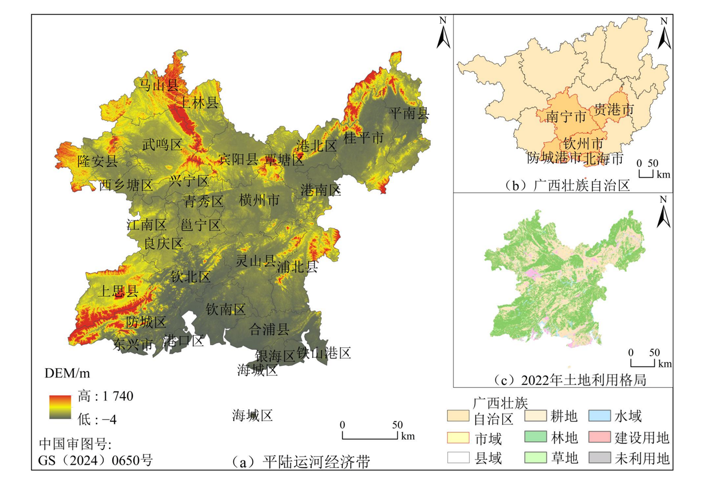
图1 研究区概况
Figure 1 Overview of the study area
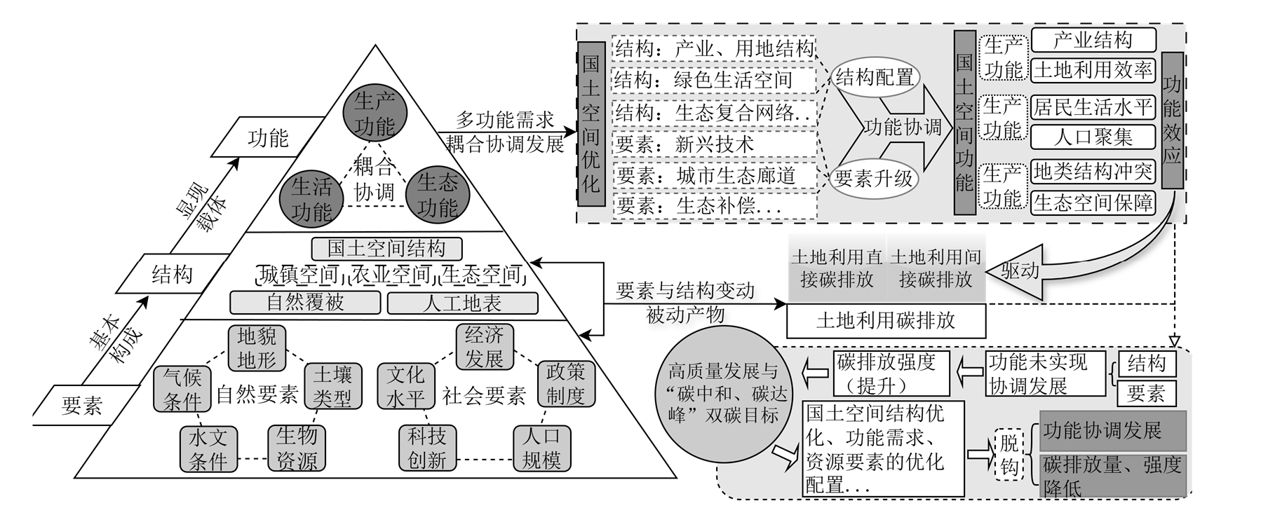
图2 国土空间功能演变与碳排放驱动机制的逻辑框架
Figure 2 A logical framework for the evolution of territorial space functions and carbon emission drivers
| 目标层 | 准则层 | 系统层 | 指标层 | 计算方式 | 权重 |
|---|---|---|---|---|---|
| 国土空间功能 | 生产功能 | 农业生产功能 | 地均粮食产量 | 粮食总产量/粮食作物播种面积 | 0.117 |
| 土地垦殖率 | 耕地面积/区域总面积 | 0.102 | |||
| 地均蔬菜产量 | 区域蔬菜产量/区域总面积 | 0.116 | |||
| 城镇生产功能 | 地均第二产业产值 | 第二产业产值/区域总面积 | 0.280 | ||
| 地均第三产业产值 | 第三产业产值/区域总面积 | 0.385 | |||
| 生活功能 | 城镇生活功能 | 建设用地密度 | 建设用地面积/区域总面积 | 0.492 | |
| 公路密度 | 公路里程数/区域总面积 | 0.044 | |||
| 地均医疗床位数 | 区域医疗床位数/区域面积 | 0.179 | |||
| 人口密度 | 区域总人口/区域总面积 | 0.265 | |||
| 农业生活功能 | 农民人均收入 | - | 0.020 | ||
| 生态功能 | 生态保育功能 | 森林覆盖率 | 林地面积/区域面积 | 0.126 | |
| 生态用地面积 | 林地、草地和水域面积总和 | 0.263 | |||
| 人均耕地面积 | 区域总人口/区域耕地面积 | 0.131 | |||
| 生态承载功能 | 固碳量 | InVEST模型 | 0.245 | ||
| 生物多样性 | InVEST模型 | 0.235 |
表1 国土空间功能评价指标体系
Table 1 Indicator system for evaluation of territorial spatial functions
| 目标层 | 准则层 | 系统层 | 指标层 | 计算方式 | 权重 |
|---|---|---|---|---|---|
| 国土空间功能 | 生产功能 | 农业生产功能 | 地均粮食产量 | 粮食总产量/粮食作物播种面积 | 0.117 |
| 土地垦殖率 | 耕地面积/区域总面积 | 0.102 | |||
| 地均蔬菜产量 | 区域蔬菜产量/区域总面积 | 0.116 | |||
| 城镇生产功能 | 地均第二产业产值 | 第二产业产值/区域总面积 | 0.280 | ||
| 地均第三产业产值 | 第三产业产值/区域总面积 | 0.385 | |||
| 生活功能 | 城镇生活功能 | 建设用地密度 | 建设用地面积/区域总面积 | 0.492 | |
| 公路密度 | 公路里程数/区域总面积 | 0.044 | |||
| 地均医疗床位数 | 区域医疗床位数/区域面积 | 0.179 | |||
| 人口密度 | 区域总人口/区域总面积 | 0.265 | |||
| 农业生活功能 | 农民人均收入 | - | 0.020 | ||
| 生态功能 | 生态保育功能 | 森林覆盖率 | 林地面积/区域面积 | 0.126 | |
| 生态用地面积 | 林地、草地和水域面积总和 | 0.263 | |||
| 人均耕地面积 | 区域总人口/区域耕地面积 | 0.131 | |||
| 生态承载功能 | 固碳量 | InVEST模型 | 0.245 | ||
| 生物多样性 | InVEST模型 | 0.235 |
| 能源类型 | 煤炭 | 焦炭 | 原油 | 汽油 | 煤油 | 柴油 | 燃烧油 | 液化石油气 | 天然气 | 电力 |
|---|---|---|---|---|---|---|---|---|---|---|
| 折标准煤系数 | 0.7143 | 0.9714 | 1.4286 | 1.4714 | 1.4714 | 1.4571 | 1.4286 | 1.7143 | 1.214 | 0.1229 |
| 碳排放系数 | 0.7559 | 0.855 | 0.5857 | 0.5538 | 0.5714 | 0.5921 | 0.6185 | 0.5042 | 0.4483 | 0.2132 |
表2 各类能源折算系数
Table 2 Energy conversion factors by type
| 能源类型 | 煤炭 | 焦炭 | 原油 | 汽油 | 煤油 | 柴油 | 燃烧油 | 液化石油气 | 天然气 | 电力 |
|---|---|---|---|---|---|---|---|---|---|---|
| 折标准煤系数 | 0.7143 | 0.9714 | 1.4286 | 1.4714 | 1.4714 | 1.4571 | 1.4286 | 1.7143 | 1.214 | 0.1229 |
| 碳排放系数 | 0.7559 | 0.855 | 0.5857 | 0.5538 | 0.5714 | 0.5921 | 0.6185 | 0.5042 | 0.4483 | 0.2132 |
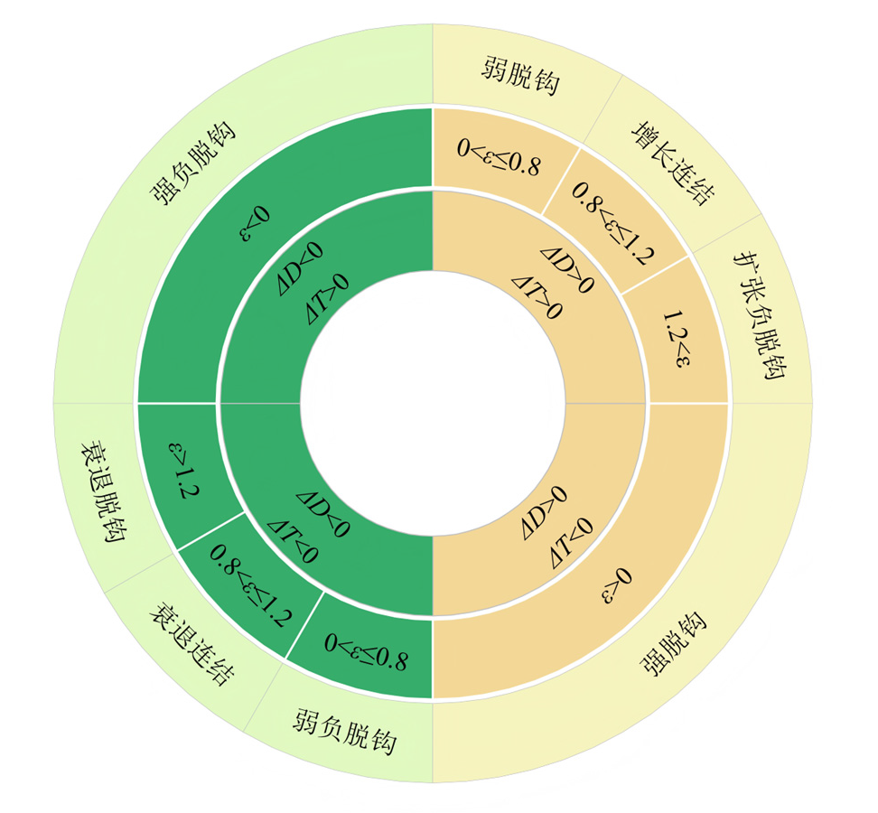
图3 脱钩状态的划分
Figure 3 Classification of decoupling states

图4 国土空间功能核密度估计曲线
Figure 4 Curve for estimating the functional core density of territorial space

图5 2010-2022年平陆运河经济带各功能的时空分异
Figure 5 Spatial and temporal differentiation of functions in the Pinglu Canal Economic Zone, 2010-2022
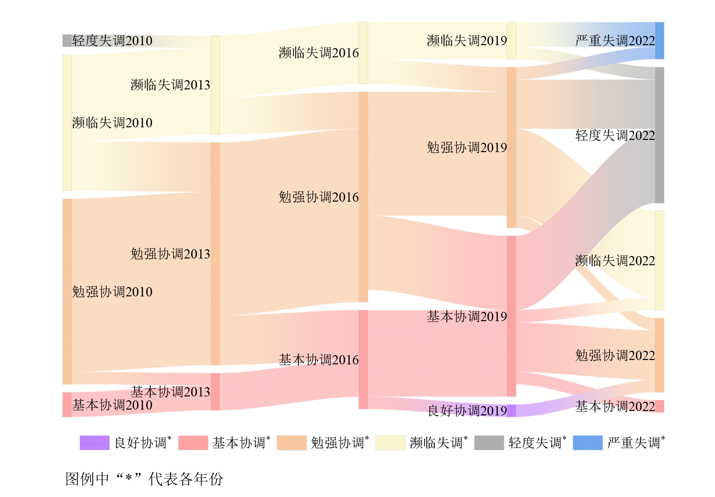
图6 2010-2022年功能耦合协调度类型的转变 图例中“*”代表各年份
Figure 6 Shift in the type of functional coupling coordination degree in 2010-2022

图7 2010-2022年土地利用直接与间接碳排放总量与变化率
Figure 7 Total direct and indirect carbon emissions from land use and rate of change, 2010-2022

图8 平陆运河经济带土地利用直接与间接碳排放量时空分异
Figure 8 Spatial and temporal variation of direct and indirect carbon emissions from land use in the Pinglu Canal Economic Zone
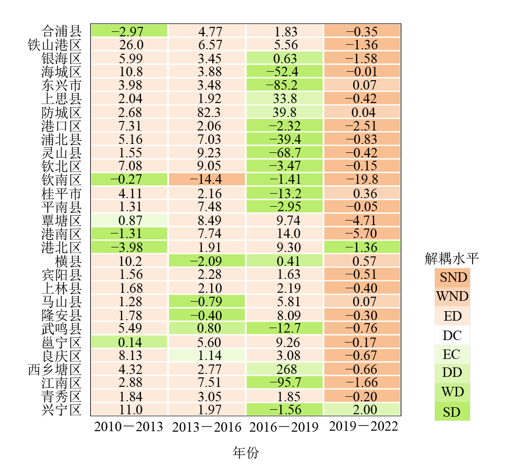
图9 2010-2022年各县区脱钩状态及水平
Figure 9 Status and level of decoupling by county in 2010-2022
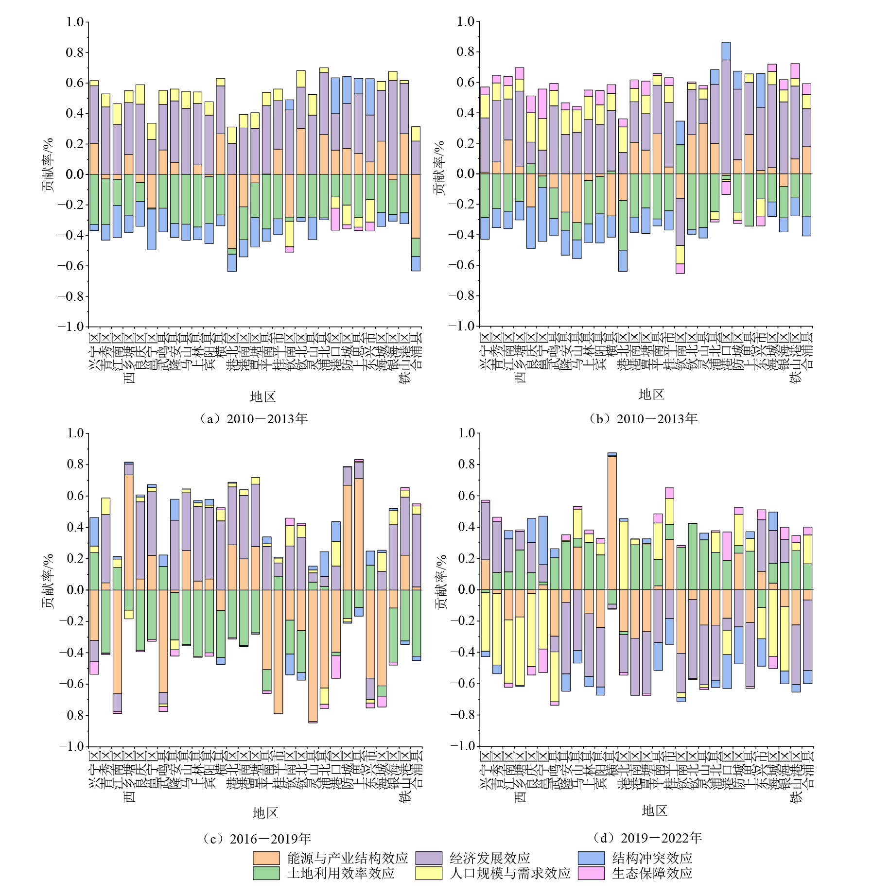
图10 脱钩状态的驱动因子分解
Figure 10 Decomposition of driving factors for decoupled states
| [1] |
DONG J, LI C B, WANG Q Q, 2021. Decomposition of carbon emission and its decoupling analysis and prediction with economic development: A case study of industrial sectors in Henan Province[J]. Journal of Cleaner Production, 321: 129019.
DOI URL |
| [2] |
DUO L, ZHONG Y, WANG J, et al., 2024. Spatio-temporal characteristics and scenario prediction of carbon emissions from land use in Jiangxi Province, China[J]. International Journal of Environmental Science and Technology, 22: 11195-11210.
DOI |
| [3] | HU H, WANG L, YANG M C, 2024. Multi-Scale analysis of spatial and temporal evolution of carbon emissions in Yangtze River Economic Belt and study of decoupling effects[J]. Sustainability, 169(10): 4222. |
| [4] |
LI L J, ZHANG X P, YU L, et al., 2024. Spatial-temporal evolution of land use carbon emissions and influencing factors in Zibo, China[J]. Frontiers in Environmental Science, 12: 1472558.
DOI URL |
| [5] |
SAJID Z W, ULLAH F, QAYYUM S, et al., 2024. Climate change mitigation through modular construction[J]. Smart Cities, 7(1): 566-596.
DOI URL |
| [6] |
TIAN C, 2024. Decoupling characteristics between coupling coordination degree of production-living-ecological function and carbon emissions in the urban agglomeration of the Shandong Peninsula[J]. Land, 13(7): 996.
DOI URL |
| [7] |
XIA L L, FU W Q, KE Y H, et al., 2025. China’s economic restructuring helps improve land-use resilience of carbon metabolism: Evidences from three Chinese megacities[J]. Applied Energy, 377: 124686.
DOI URL |
| [8] |
YANG B, CHEN X, WANG Z Q, et al., 2020. Analyzing land use structure efficiency with carbon emissions: A case study in the Middle Reaches of the Yangtze River, China[J]. Journal of Cleaner Production, 274: 123076.
DOI URL |
| [9] |
陈洁茹, 叶长盛, 魏嶶, 等, 2025. 环鄱阳湖城市群县域 “三生空间” 耦合协调性及影响因素分析[J]. 生态环境学报, 34(5): 807-818.
DOI |
| CHEN J R, YE C S, WEI W, et al., 2025. Analysis of “Production-Living-Ecological Space” coupling coordination and influencing factors in county areas of Poyang Lake city cluster[J]. Ecology and Environmental Sciences, 34(5): 807-818. | |
| [10] | 陈可欣, 陶韦华, 方晓丽, 等, 2022. 国土空间规划中碳中和评估及规划应用路径研究[J]. 规划师, 38(5): 134-141. |
| CHEN K X, TAO W H, FANG X L, et al., 2022. Carbon neutrality assessment and planning application path in territorial spatial planning[J]. Planners, 38(5):134-141. | |
| [11] |
丁明磊, 杨晓娜, 赵荣钦, 等, 2022. 碳中和目标下的国土空间格局优化: 理论框架与实践策略[J]. 自然资源学报, 37(5): 1137-1147.
DOI |
|
DING M L, YANG X N, ZHAO R Q, et al., 2022. Optimization of territorial space pattern under the goal of carbon neutrality: Theoretical framework and practical strategy[J]. Journal of Natural Resources, 37(5): 1137-1147.
DOI URL |
|
| [12] |
范业婷, 金晓斌, 项晓敏, 等, 2019. 江苏省土地利用功能变化及其空间格局特征[J]. 地理研究, 38(2): 383-398.
DOI |
| FAN Y T, JIN X B, XIANG X M, et al., 2019. Land use functions change and its spatial pattern in Jiangsu province from 2000 to 2015[J]. Geographical Research, 38(2): 383-398. | |
| [13] |
范清瑶, 夏卫生, 莫成鑫, 2023. 基于 “三生空间” 的土地利用转型时空演变及其碳排放效应研究——以福建省为例[J]. 生态环境学报, 32(12): 2183-2193.
DOI |
| FANG Q Y, XIA W S, MO C X, 2023. Study on transition of land use function and its carbon emissioneffect repose based on the conception of “production, living and ecological space”: A case study of Fujian Province[J]. Ecology and Environmental Sciences, 32(12): 2183-2193. | |
| [14] | 奉婷, 余筱东, 董仁玲, 等, 2024. 耦合视角下广西北部湾经济区 “三生” 功能协调度的时空演变与影响因素[J]. 中国农业大学学报, 29(12): 303-316. |
| FENG T, YU X D, DONG R L, et al., 2024. Spatial-temporal evolution and influencing factors of the coordination degree of “production-living-ecological” functions in Guangxi Beibu Gulf Economic Zone from the coupling perspective[J]. Journal of China Agricultural University, 29(12): 303-316. | |
| [15] |
冯琰玮, 甄江红, 2022. 国土空间功能演变及协同/权衡关系研究——以内蒙古呼包鄂地区为例[J]. 干旱区研究, 39(5): 1642-1654.
DOI |
| FENG Y W, ZHEN J H, 2022. Study on the adaptation of the land’s functions and its synergy/trade-off relationship: A case study of Hohhot-Baotou-Ordos region, Inner Mongolia[J]. Arid Land Geography, 39(5): 1642-1654. | |
| [16] | 胡冉再琪, 孔雪松, 文高辉, 等, 2024. 武汉城市圈 “三生” 功能与土地利用碳排放耦合测度及协同分区[J]. 中国农业资源与区划, 45(5): 209-221. |
| HU R Z Q, KONG X S, WEN G H, et al., 2024. The coupling measurement and co-zoning of Production-Living-Ecological functions and land use carbon emission in Wuhan metropolitan region[J]. China Agricultural Resources and Regional Planning, 45(5): 209-221. | |
| [17] |
黄安, 许月卿, 卢龙辉, 等, 2020. “生产-生活-生态” 空间识别与优化研究进展[J]. 地理科学进展, 39(3): 503-518.
DOI |
|
HUANG A, XU Y Q, LU L H, et al., 2020. Research progress of the identification and optimization of production-living-ecological spaces[J]. Progress in Geography, 39(3): 503-518.
DOI |
|
| [18] | 黄栋, 刘跃宗, 刘建宁, 等, 2024. 辽宁省 “三生” 功能时空演变及其碳排放效应[J]. 水土保持通报, 44(1): 421-431. |
| HUANG D, LIU Y Z, LIU J N, et al., 2024. Spatial-temporal evolution of Productional-Living-Ecological functions and their carbon emission effects in Liaoning Province[J]. Bulletin of Soil and Water Conservation, 44(1): 421-431. | |
| [19] | 黄淼, 文宁, 李亚涛, 等, 2024. 碳中和目标下湖南省 “三生” 空间碳排放系数测度与战略模拟[J]. 水土保持通报, 44(5): 382-391. |
| HUANG M, WEN N, LI Y T, et al., 2024. Productional-Living-Ecological space carbon emissions analysis and strategic simulation in Hunan province under target of carbon neutrality[J]. Research of Soil and Water Conservation, 44(5): 382-391. | |
| [20] | 雷文韬, 古杰, 谢宏坤, 2024. 基于 “三生” 空间的湖南省土地利用格局及多功能演变[J]. 农业工程学报, 40(17): 283-293. |
| LEI W T, GU J, XIE H K, 2024. Land use pattern and multifunctional evolution in Hunan Province using “production-living-ecosystem” space[J]. Transactions of the Chinese Society of Agricultural Engineering, 40(17): 283-293. | |
| [21] | 李虹, 张红, 贺桂珍, 等, 2024. 基于主体功能区的山西省碳排放时空特征及减排评价[J]. 生态学报, 44(1): 143-153. |
| LI H, ZHANG H, HE G Z, et al., 2024. Spatio-temporal characteristics and reduction evaluation of carbon emission from the perspective of Major Function Oriented Zones, Shanxi Province[J]. Acta Ecologica Sinice, 44(1): 143-153. | |
| [22] | 李凯, 蔺雪芹, 崔惟佳, 2023. 主体功能区视角下河南省碳排放时空演化特征及驱动因素[J]. 西安理工大学学报, 39(3): 317-329. |
| LI K, LIN X Q, CUI WJ, 2023. Spatio-temporal evolution characteristics and driving factors of carbon emission in Henan Province from the perspective of major functional zones[J]. Journal of Xi’an University of Technology, 39(3): 317-329. | |
| [23] | 林树高, 陆汝成, 刘少坤, 等, 2021. 基于 “三生” 空间的广西边境地区土地利用格局及多功能演变[J]. 农业工程学报, 37(5): 265-274. |
| LIN S G, LU R C, LIU S K, et al., 2021. Land use pattern and multifunctional evolution in the border areas in the Guangxi Zhuang Autonomous Region based on “production-living-ecosystem” space[J]. Transactions of the ChineseSociety of Agricultural Engineering, 37(5): 265-274. | |
| [24] | 刘春艳, 张继飞, 赵宇鸾, 等, 2018. 基于生态位理论的国土空间功能重要性评估——以攀西地区为例[J]. 城市规划, 42(4): 84-93. |
| LIU Z Y, ZHANG J F, ZHAO Y L, et al., 2018. Significance evaluation for territorial functions based on niche theory: A case study on Panxi area[J]. City Planning Review, 42(4): 84-93. | |
| [25] |
罗光浴, 王志远, 2024. 洞庭湖生态经济区国土空间格局演变的碳储量效应及驱动因素研究[J]. 生态环境学报, 33(11): 1672-1685.
DOI |
| LUO G Y, WNAG Z Y, 2024. Research on the carbon storage effect and driving factors of the evolution of territorial space pattern in Dongting lake ecological and economic zone[J]. Ecology and Environmental Sciences, 33(11): 1672-1685. | |
| [26] |
江东, 林刚, 付晶莹, 2021. “三生空间”统筹的科学基础与优化途径探析[J]. 自然资源学报, 36(5): 1085-1101.
DOI |
|
JIANG D, LIN G, FU J Y, 2021. Discussion on scientific foundation and approach for the overall optimization of “Production-Living-Ecological” space[J]. Journal of Natural Resources, 36(5): 1085-1101.
DOI |
|
| [27] |
孔冬艳, 陈会广, 吴孔森, 2021. 中国 “三生空间” 演变特征、生态环境效应及其影响因素[J]. 自然资源学报, 36(5): 1116-1135.
DOI |
|
KONG D Y, CHEN H G, WU K S, 2021. The evolution of ‘Production-Living-Ecological’ space, eco-environmental effects and its influencing factors in China[J]. Journal of Natural Resources, 36(5): 1116-1135.
DOI URL |
|
| [28] |
王宏亮, 邱嘉政, 吴健生, 2025. 双碳目标下呼包鄂城市群多情景土地利用优化分析[J]. 地理研究, 44(3): 656-675.
DOI |
| WANG H L, QIU J Z, WU J S, 2025. Multi-scenario land use optimization analysis of the Hohhot-Baotou-Ordos urban agglomeration under dual carbon targets[J]. Geographical Research, 44(3): 656-675. | |
| [29] | 王丽蓉, 石培基, 尹君锋, 等, 2024. 碳中和视角下甘肃省县域碳收支时空分异与国土空间分区优化[J]. 环境科学, 45(7): 4101-4111. |
| WANG L Y, SHI P J, YIN J F, et al., 2024. Spatio-temporal differentiation of county carbon budget and territorial space optimization zoning strategy in Gansu Province from the perspective of carbon neutrality[J]. Environmental Science, 45(7): 4101-4111. | |
| [30] |
王少剑, 高爽, 2024. 面向碳中和的中国国土空间优化与减排增汇实践路径[J]. 经济地理, 44(9): 163-173.
DOI |
|
WANG S J, GAO S, 2024. Territorial space optimization and pathways for carbon emission reduction and carbon sink enhancement in China towards carbon neutrality[J]. Economic Geography, 44(9): 163-173.
DOI |
|
| [31] |
王正, 周侃, 樊杰, 等, 2023. 市-县尺度能源消费碳排放核算方法研究进展[J]. 地理科学进展, 42(7): 1406-1419.
DOI |
|
WANG Z, ZHOU K, FAN J, et al., 2023. Progress of research on energy-related carbon emission accounting methods at the prefectural and county levels[J]. Progress in Geography, 42(7): 1406-1419.
DOI |
|
| [32] |
夏四友, 杨宇, 2022. 基于主体功能区的京津冀城市群碳收支时空分异与碳补偿分区[J]. 地理学报, 77(3): 679-696.
DOI |
|
XIA S Y, YANG Y, 2022. Spatio-temporal differentiation of carbon budget and carbon compensation zoning in Beijing-Tianjin-Hebei Urban Agglomeration based on the plan for major function-oriented zones[J]. Acta Geographica Sinica, 77(3): 679-696.
DOI |
|
| [33] | 向芳芳, 何风琴, 黄丽萍, 等, 2024. 快速城镇化地区国土空间碳汇冲突评价及其异质性分析——以京津冀城市群为例[J]. 生态学报, 44(23): 10676-10687. |
| XIANG F F, HE F Q, HUANG L P, et al., 2024. Intensity evaluation and heterogeneity analysis of territorial spatial carbon sink conflicts in rapidly urbanized regions: a case study of Beijing-Tianjin-Hebei city cluster[J]. Acta Ecologica Sinice, 44(23): 10676-10687. | |
| [34] | 徐慧, 刘希, 刘嗣明, 2022. 推动绿色发展,促进人与自然和谐共生——习近平生态文明思想的形成发展及在二十大的创新[J]. 宁夏社会科学 (6): 5-19. |
| XU H, LIU X, LIU S M, 2020. Promote green development and advance the harmonious symbiosis between human and nature: The formation and development of Xi Jinping’s thought on socialist ecological civilization with Chinese characteristics for a new era and the innovation in the 20th national congress[J]. Social Sciences in Ningxia (6): 5-19. | |
| [35] | 张雅娉, 张建军, 苏佳佳, 等, 2025. 资源型城市不同功能区的碳排放差异及影响因素识别[J]. 环境科学, 46(7): 4110-4118. |
| ZHANG Y P, ZHANG J J, SU J J, et al., 2025. Carbon emission difference and influencing factors identification in different functional areas of resource-based cities[J]. Environmental Science, 46(7): 4110-4118. | |
| [36] | 朱从谋, 王珂, 张晶, 等, 2022. 国土空间治理内涵及实现路径——基于 “要素-结构-功能-价值” 视角[J]. 中国土地科学, 36(2): 10-18. |
| ZHU C M, WANG K, ZHANG J, et al., 2022. The connotation and realization path of territorial space governance from the perspective of “Elements-Structure-Function-Value”[J]. China Land Science, 36(2): 10-18. | |
| [37] |
邹利林, 章丽君, 梁一凡, 等, 2022. 新时代国土空间功能的科学认知与研究框架[J]. 自然资源学报, 37(12): 3060-3072.
DOI |
|
ZOU L L, ZHANG L J, LIANG Y F, et al., 2022. Scientific cognition and research framework of territorial space function in the New Era[J]. Journal of Natural Resources, 37(12): 3060-3072.
DOI URL |
| [1] | 冯珊珊, 陶亮, 梁俊芬. 高质量发展视角下县域农业产业集聚的时空演化与驱动机制——以广东省蔬菜生产为例[J]. 生态环境学报, 2025, 34(8): 1293-1304. |
| [2] | 奥勇, 倪赟, 赵永华, 丁志豪, 黄福星, 李敏. 生态韧性视角下陕西省绿色空间的时空演变特征及其驱动机制[J]. 生态环境学报, 2025, 34(12): 1866-1878. |
| [3] | 王金杰, 赵安周, 胡小枫. 京津冀植被净初级生产力时空分布及自然驱动因子分析[J]. 生态环境学报, 2021, 30(6): 1158-1167. |
| 阅读次数 | ||||||
|
全文 |
|
|||||
|
摘要 |
|
|||||