生态环境学报 ›› 2026, Vol. 35 ›› Issue (5): 805-818.DOI: 10.16258/j.cnki.1674-5906.2026.05.013
虞江浩1,2,3( ), 刘晓煌2,3,4,*(), 祝萍2,3,4, 刘润2,3,4, 李洪宇2,3,4, 吴广杰2,3,4, 马敏2,3,4, 刘潇桐2,3,4
收稿日期:2025-06-13
修回日期:2025-10-20
接受日期:2025-11-20
出版日期:2026-05-18
发布日期:2026-05-08
通讯作者:
*E-mail: 作者简介:虞江浩(2002年生),男,硕士研究生,主要研究方向为生态系统服务。E-mail: yawyl@cug.edu.cn
基金资助:
YU Jianghao1,2,3(), LIU Xiaohuang2,3,4,*(), ZHU Ping2,3,4, LIU Run2,3,4, LI Hongyu2,3,4, WU Guangjie2,3,4, MA Min2,3,4, LIU Xiaotong2,3,4
Received:2025-06-13
Revised:2025-10-20
Accepted:2025-11-20
Online:2026-05-18
Published:2026-05-08
摘要:
伊犁河流域作为中国西北生态安全屏障和重要农牧业生产区,面临生态保护、资源开发与民生保障多目标交织的空间治理难题。为科学识别伊犁河流域“三生”空间(生产、生活、生态)功能冲突与演化趋势,该文在格网尺度上开展“三生”空间适宜性评价,用耦合协调度模型诊断其耦合协调状况,并利用FLUS模型模拟过去(2000、2010、2020年)“三生”空间格局演变过程,探讨未来(2030年)伊犁河流域“三生”空间优化路径。结果表明:1)2000-2020年间,流域生产空间和生活空间分别由13.1%、1.14%增长至16.8%、1.39%,生态空间则由85.8%下降至81.8%,呈现出人类活动空间稳步扩张、生态空间被压缩的趋势;2)“三生”空间协调性整体提升,中度失调和严重失调区域减少,高度协调区占比上升,表明区域功能耦合趋于稳定;3)FLUS模拟结果显示,在生态保护与粮食安全并重的发展情景下,生态空间仍维持主导地位,生产与生活空间适度集约提升,空间结构更加合理。优化路径体现了对生态保护红线的有效守护与人地系统协调治理的深化探索。该研究可为西部干旱区复杂流域单元的国土空间规划与“三生”空间优化提供方法支撑与案例借鉴。
中图分类号:
虞江浩, 刘晓煌, 祝萍, 刘润, 李洪宇, 吴广杰, 马敏, 刘潇桐. 新疆伊犁河流域国土空间“三生”功能评价及优化路径[J]. 生态环境学报, 2026, 35(5): 805-818.
YU Jianghao, LIU Xiaohuang, ZHU Ping, LIU Run, LI Hongyu, WU Guangjie, MA Min, LIU Xiaotong. Evaluation and Optimization Path of Territorial Spatial “Production-Living-Ecological” Functions in the Ili River Basin, Xinjiang[J]. Ecology and Environmental Sciences, 2026, 35(5): 805-818.

图1 研究区概况 该图基于中华人民共和国自然资源部下载的审图号为GS(2024)0650号的标准地图制作;底图边界无修改。下同
Figure 1 The overview of the studied area
| 数据类型 | 指标(因子名称及计量单位) | 数据来源 | 空间分辨率 |
|---|---|---|---|
| 土地利用类型 | 土地利用分类 | 中国科学院资源环境科学与数据中心( | 30 m |
| 地形 | DEM高程/m | 地理空间数据云 | 250 m |
| 坡度/° | 由DEM计算获得 | 250 m | |
| 气象 | 年平均气温/℃ | 国家气象科学数据中心( | 30 m |
| 年平均降水/mm | 30 m | ||
| 土壤 | 表层土壤有机质质量分数/(g∙kg−1) | 国家地球系统科学数据中心土壤分中心( | 1 km |
| 表层土壤pH值 | 1 km | ||
| 土壤水力侵蚀强度 | 中国科学院资源环境科学与数据中心( | 1 km | |
| 植被 | 归一化植被指数(NDVI) | 1 km | |
| 水文 | 水系 | 全国地理信息资源目录服务系统( | 30 m |
| 基础地理信息 | 居民用地 | 30 m | |
| 道路 | 30 m | ||
| 夜间灯光强度指数 | 美国国家海洋和大气管理局( | 1 km | |
| 社会经济数据 | GDP,POP,耕地面积,工业产值等 | 《伊犁统计年鉴》《伊犁哈萨克自治州统计年鉴》 |
表1 研究数据来源
Table 1 Research data source
| 数据类型 | 指标(因子名称及计量单位) | 数据来源 | 空间分辨率 |
|---|---|---|---|
| 土地利用类型 | 土地利用分类 | 中国科学院资源环境科学与数据中心( | 30 m |
| 地形 | DEM高程/m | 地理空间数据云 | 250 m |
| 坡度/° | 由DEM计算获得 | 250 m | |
| 气象 | 年平均气温/℃ | 国家气象科学数据中心( | 30 m |
| 年平均降水/mm | 30 m | ||
| 土壤 | 表层土壤有机质质量分数/(g∙kg−1) | 国家地球系统科学数据中心土壤分中心( | 1 km |
| 表层土壤pH值 | 1 km | ||
| 土壤水力侵蚀强度 | 中国科学院资源环境科学与数据中心( | 1 km | |
| 植被 | 归一化植被指数(NDVI) | 1 km | |
| 水文 | 水系 | 全国地理信息资源目录服务系统( | 30 m |
| 基础地理信息 | 居民用地 | 30 m | |
| 道路 | 30 m | ||
| 夜间灯光强度指数 | 美国国家海洋和大气管理局( | 1 km | |
| 社会经济数据 | GDP,POP,耕地面积,工业产值等 | 《伊犁统计年鉴》《伊犁哈萨克自治州统计年鉴》 |
| 分类体系 | 土地利用类型 | 属性说明 | |
|---|---|---|---|
| 一级分类 | 二级分类 | ||
| 生产空间 | 农业生产空间 | 水田,旱地 | 为人类提供直接的农产品,是粮食和经济作物生产的主要来源 |
| 工业生产空间 | 工矿、交通建设用地 | ||
| 生活空间 | 城镇生活空间 | 城镇建设用地 | 主要满足城市居民的生活需求,为城市人口提供居住和工作场所 |
| 农村生活空间 | 农村居民点用地 | 满足乡村地区居民的生活需求,通常包含住房和小型农业生产活动场所 | |
| 生态空间 | 林地生态空间 | 有林地,灌木林地,疏林地,其他林地 | 保持水土,保证生态循环,维持生态系统平衡 |
| 草地生态空间 | 高、中、低覆盖度草地 | 提供牧草资源,同时防风固沙,维护区域生态稳定性 | |
| 水域生态空间 | 河流,湖泊,水库坑塘,湿地,滩涂 | 稳定区域温度,具备自我环境净化能力,是重要的生态用地 | |
| 其他生态空间 | 冰川,沙地,裸地,其他未利用地 | 通常难以开发利用,具有维持生态服务功能的意义 | |
表2 “三生”空间功能识别与分类体系
Table 2 Classification system of production-living-ecological space
| 分类体系 | 土地利用类型 | 属性说明 | |
|---|---|---|---|
| 一级分类 | 二级分类 | ||
| 生产空间 | 农业生产空间 | 水田,旱地 | 为人类提供直接的农产品,是粮食和经济作物生产的主要来源 |
| 工业生产空间 | 工矿、交通建设用地 | ||
| 生活空间 | 城镇生活空间 | 城镇建设用地 | 主要满足城市居民的生活需求,为城市人口提供居住和工作场所 |
| 农村生活空间 | 农村居民点用地 | 满足乡村地区居民的生活需求,通常包含住房和小型农业生产活动场所 | |
| 生态空间 | 林地生态空间 | 有林地,灌木林地,疏林地,其他林地 | 保持水土,保证生态循环,维持生态系统平衡 |
| 草地生态空间 | 高、中、低覆盖度草地 | 提供牧草资源,同时防风固沙,维护区域生态稳定性 | |
| 水域生态空间 | 河流,湖泊,水库坑塘,湿地,滩涂 | 稳定区域温度,具备自我环境净化能力,是重要的生态用地 | |
| 其他生态空间 | 冰川,沙地,裸地,其他未利用地 | 通常难以开发利用,具有维持生态服务功能的意义 | |
| 空间类型 | 指标 | 指标分级和打分 | ||||
|---|---|---|---|---|---|---|
| 权重 | 100 | 80 | 60 | 40 | ||
| 生产空间 | 土地利用类型 | 0.211 | 水田,旱地,草地 | 建设用地,河流,湖泊 | 林地 | 其他 |
| 高程/m | 0.069 | ≤1300 | [1300, 2150) | [2150, 3050) | ≥3050 | |
| 坡度/° | 0.072 | ≤5.5 | [5.5, 13) | [13, 22.5) | ≥22.5 | |
| 年平均气温/℃ | 0.039 | [8, 12) | [3, 8) | [0, 3) | ≤0 | |
| 年降雨量/mm | 0.039 | ≥451 | [352, 451) | [278, 352) | ≤278 | |
| 有机质质量分数/(g∙kg−1) | 0.124 | [21, 49] | [13, 21) | [6, 13) | ≤6 | |
| pH值 | 0.181 | [6.5, 7.5) | [6.0, 6.5) | [7.5, 8.0) | 其他 | |
| 土壤水力侵蚀 | 0.072 | ≤1 | [1, 2) | [2, 3) | ≥3 | |
| 路网密度 | 0.116 | [0.7, 1] | [0.5, 0.7) | [0.3, 0.5) | ≤0.3 | |
| 到水系距离/km | 0.078 | ≤1.5 | [1.5, 4) | [4, 6) | ≥6 | |
| 生活空间 | 土地利用类型 | 0.292 | 建设用地 | 水田,旱地 | 林地,草地,湖泊 | 其他 |
| 高程/m | 0.047 | ≤1300 | [1300, 2150) | [2150, 3050) | ≥3050 | |
| 坡度/° | 0.047 | ≤5.5 | [5.5, 13) | [13, 22.5) | ≥22.5 | |
| 距主要道路距离/m | 0.186 | [0, 3000) | [3000, 5000) | [5000, 10000) | ≥10000 | |
| 距居民区距离/km | 0.121 | [0, 7) | [7, 15) | [15, 25) | ≥25 | |
| 经济密度/(104 yuan∙km−2) | 0.115 | ≥2000 | [1000, 2000) | [500, 1000) | [0, 500] | |
| 人口密度/(person∙km−2) | 0.080 | ≥4500 | [3000, 4500) | [1000, 3000) | [0, 1000) | |
| 夜间灯光 | 0.112 | ≥37 | [14, 37) | [3.5, 14) | [0, 3.5] | |
| 生态空间 | 土地利用类型 | 0.238 | 林地,草地 | 河流,湖泊,湿地 | 水田,旱地,未利用地 | 其他 |
| 高程/m | 0.071 | ≥3050 | [2150, 3050) | [1300, 2150) | ≤1300 | |
| 坡度/° | 0.071 | ≥22.5 | [13, 22.5) | [5.5, 13) | [0, 5.5) | |
| NDVI | 0.143 | ≥0.5 | [0.25, 0.5) | [0.15, 0.25) | ≤0.15 | |
| 到水系距离/km | 0.095 | ≥6 | [4, 6) | [1.6, 4) | ≤1.6 | |
| 距居民区距离/km | 0.143 | ≥12 | [9, 12) | [6, 9) | ≤6 | |
| 景观破碎度 | 0.095 | [6.5, 7.5) | [6.0, 6.5) | [7.5, 8.0) | 其他 | |
| 土壤水力侵蚀 | 0.143 | ≤1 | [1, 2) | [2, 3) | ≥3 | |
表3 “三生”空间适宜性评价体系
Table 3 Index system of production-living-ecological space suitability evaluation
| 空间类型 | 指标 | 指标分级和打分 | ||||
|---|---|---|---|---|---|---|
| 权重 | 100 | 80 | 60 | 40 | ||
| 生产空间 | 土地利用类型 | 0.211 | 水田,旱地,草地 | 建设用地,河流,湖泊 | 林地 | 其他 |
| 高程/m | 0.069 | ≤1300 | [1300, 2150) | [2150, 3050) | ≥3050 | |
| 坡度/° | 0.072 | ≤5.5 | [5.5, 13) | [13, 22.5) | ≥22.5 | |
| 年平均气温/℃ | 0.039 | [8, 12) | [3, 8) | [0, 3) | ≤0 | |
| 年降雨量/mm | 0.039 | ≥451 | [352, 451) | [278, 352) | ≤278 | |
| 有机质质量分数/(g∙kg−1) | 0.124 | [21, 49] | [13, 21) | [6, 13) | ≤6 | |
| pH值 | 0.181 | [6.5, 7.5) | [6.0, 6.5) | [7.5, 8.0) | 其他 | |
| 土壤水力侵蚀 | 0.072 | ≤1 | [1, 2) | [2, 3) | ≥3 | |
| 路网密度 | 0.116 | [0.7, 1] | [0.5, 0.7) | [0.3, 0.5) | ≤0.3 | |
| 到水系距离/km | 0.078 | ≤1.5 | [1.5, 4) | [4, 6) | ≥6 | |
| 生活空间 | 土地利用类型 | 0.292 | 建设用地 | 水田,旱地 | 林地,草地,湖泊 | 其他 |
| 高程/m | 0.047 | ≤1300 | [1300, 2150) | [2150, 3050) | ≥3050 | |
| 坡度/° | 0.047 | ≤5.5 | [5.5, 13) | [13, 22.5) | ≥22.5 | |
| 距主要道路距离/m | 0.186 | [0, 3000) | [3000, 5000) | [5000, 10000) | ≥10000 | |
| 距居民区距离/km | 0.121 | [0, 7) | [7, 15) | [15, 25) | ≥25 | |
| 经济密度/(104 yuan∙km−2) | 0.115 | ≥2000 | [1000, 2000) | [500, 1000) | [0, 500] | |
| 人口密度/(person∙km−2) | 0.080 | ≥4500 | [3000, 4500) | [1000, 3000) | [0, 1000) | |
| 夜间灯光 | 0.112 | ≥37 | [14, 37) | [3.5, 14) | [0, 3.5] | |
| 生态空间 | 土地利用类型 | 0.238 | 林地,草地 | 河流,湖泊,湿地 | 水田,旱地,未利用地 | 其他 |
| 高程/m | 0.071 | ≥3050 | [2150, 3050) | [1300, 2150) | ≤1300 | |
| 坡度/° | 0.071 | ≥22.5 | [13, 22.5) | [5.5, 13) | [0, 5.5) | |
| NDVI | 0.143 | ≥0.5 | [0.25, 0.5) | [0.15, 0.25) | ≤0.15 | |
| 到水系距离/km | 0.095 | ≥6 | [4, 6) | [1.6, 4) | ≤1.6 | |
| 距居民区距离/km | 0.143 | ≥12 | [9, 12) | [6, 9) | ≤6 | |
| 景观破碎度 | 0.095 | [6.5, 7.5) | [6.0, 6.5) | [7.5, 8.0) | 其他 | |
| 土壤水力侵蚀 | 0.143 | ≤1 | [1, 2) | [2, 3) | ≥3 | |
| 一级功能 | 二级功能 | 指标 | 2000年权重 | 2010年权重 | 2020年权重 | 数据获取 |
|---|---|---|---|---|---|---|
| 生产功能 | 农业生产功能 | 耕地面积占比 | 0.066 | 0.067 | 0.059 | 耕地面积/行政单元总面积 |
| 粮食人均占有量 | 0.053 | 0.059 | 0.059 | 粮食产量/人口数量 | ||
| 粮食产出率 | 0.084 | 0.055 | 0.060 | 粮食产量/耕地面积 | ||
| 经济生产功能 | 工业总产值 | 0.053 | 0.056 | 0.062 | 工业总产值 | |
| 二三产业比重 | 0.064 | 0.068 | 0.061 | 二三产业产值/总产值 | ||
| 土地产出率 | 0.049 | 0.050 | 0.049 | 总产值/行政单元总面积 | ||
| 生活功能 | 社会保障功能 | 人均生产总值 | 0.080 | 0.056 | 0.054 | 生产总值/地区人口总数 |
| 受教育程度 | 0.049 | 0.073 | 0.101 | 毕业人数/人口数量 | ||
| 城镇化水平 | 0.059 | 0.068 | 0.053 | 城镇人口/总人口 | ||
| 居住承载功能 | 人口密度 | 0.077 | 0.087 | 0.096 | 总人口/行政单元总面积 | |
| 生活用地面积比重 | 0.068 | 0.067 | 0.064 | 二三产业产值/总产值 | ||
| 路网通达性 | 0.059 | 0.058 | 0.055 | 道路长度/行政单元总面积 | ||
| 生态功能 | 生态维持功能 | 水域覆盖率 | 0.067 | 0.066 | 0.063 | 水域面积/行政单元总面积 |
| 草地覆盖率 | 0.081 | 0.080 | 0.077 | 草地面积/行政单元总面积 | ||
| 林地覆盖率 | 0.092 | 0.091 | 0.087 | 林地面积/行政单元总面积 |
表4 “三生”空间功能耦合协同发展评价指标体系
Table 4 Index system of coupling coordination degree evaluation for production-living-ecological space
| 一级功能 | 二级功能 | 指标 | 2000年权重 | 2010年权重 | 2020年权重 | 数据获取 |
|---|---|---|---|---|---|---|
| 生产功能 | 农业生产功能 | 耕地面积占比 | 0.066 | 0.067 | 0.059 | 耕地面积/行政单元总面积 |
| 粮食人均占有量 | 0.053 | 0.059 | 0.059 | 粮食产量/人口数量 | ||
| 粮食产出率 | 0.084 | 0.055 | 0.060 | 粮食产量/耕地面积 | ||
| 经济生产功能 | 工业总产值 | 0.053 | 0.056 | 0.062 | 工业总产值 | |
| 二三产业比重 | 0.064 | 0.068 | 0.061 | 二三产业产值/总产值 | ||
| 土地产出率 | 0.049 | 0.050 | 0.049 | 总产值/行政单元总面积 | ||
| 生活功能 | 社会保障功能 | 人均生产总值 | 0.080 | 0.056 | 0.054 | 生产总值/地区人口总数 |
| 受教育程度 | 0.049 | 0.073 | 0.101 | 毕业人数/人口数量 | ||
| 城镇化水平 | 0.059 | 0.068 | 0.053 | 城镇人口/总人口 | ||
| 居住承载功能 | 人口密度 | 0.077 | 0.087 | 0.096 | 总人口/行政单元总面积 | |
| 生活用地面积比重 | 0.068 | 0.067 | 0.064 | 二三产业产值/总产值 | ||
| 路网通达性 | 0.059 | 0.058 | 0.055 | 道路长度/行政单元总面积 | ||
| 生态功能 | 生态维持功能 | 水域覆盖率 | 0.067 | 0.066 | 0.063 | 水域面积/行政单元总面积 |
| 草地覆盖率 | 0.081 | 0.080 | 0.077 | 草地面积/行政单元总面积 | ||
| 林地覆盖率 | 0.092 | 0.091 | 0.087 | 林地面积/行政单元总面积 |
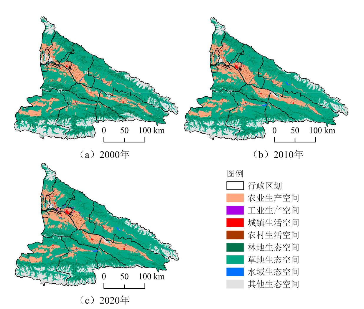
图2 伊犁河流域“三生”空间划分
Figure 2 Spatial distribution of production-living-ecological space in Yili River Basin

图3 伊犁河流域“三生”空间适宜性评价
Figure 3 Suitability evaluation of production-living-ecological space in Yili River Basin
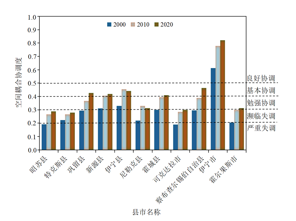
图4 伊犁河流域“三生”空间功能可持续性评价
Figure 4 Sustainability evaluation of production-living-ecological space in Yili River Basin
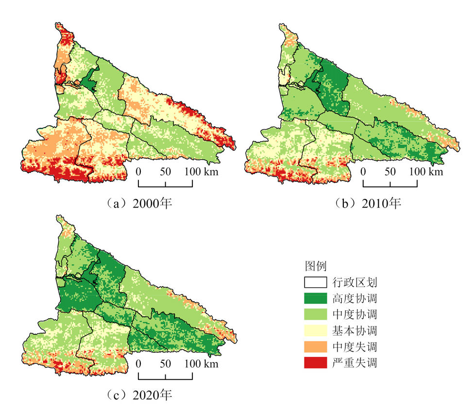
图5 伊犁河流域多尺度下的“三生”功能冲突耦合协调评价结果
Figure 5 Coupling and coordination degree evaluation of production-living-ecological space on multi-scale in Yili River Basin
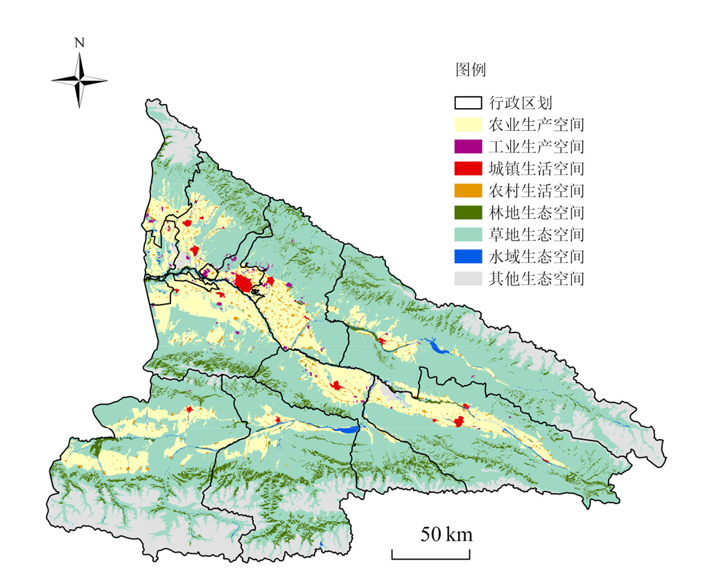
图6 生态保护与粮食安全综合发展情景下三生空间模拟分布图
Figure 6 Simulated distribution of production-living-ecological spaces under the integrated development scenario of ecological protection and food security

图7 生态保护与粮食安全综合发展情景下三生空间变化分布图
Figure 7 Distribution map of production-living-ecological space changes under the integrated development scenario of ecological protection and food security
| [1] |
GAO Y, BAI L Y, ZHOU K F, et al., 2024. Study on the coupling coordination degree and driving mechanism of “production-living-ecological” space in ecologically fragile areas: A case study of the Turpan-Hami Basin[J]. Sustainability, 16(20): 9054.
DOI URL |
| [2] |
HUANG Y, LI H M, 2012. Rational distribution and adjusting strategies of the industrial structure in the Ili River Basin based on sustainable development[J]. Applied Mechanics and Materials, 174-177: 3420-3425.
DOI URL |
| [3] |
SUN H L, CHEN Y N, LI W H, et al., 2010. Variation and abrupt change of climate in Ili River Basin, Xinjiang[J]. Journal of Geographical Sciences, 20(5): 652-666.
DOI |
| [4] |
WANG C, WANG H W, WU J H, et al., 2024. Identifying and warning against spatial conflicts of land use from an ecological environment perspective: A case study of the Ili River Valley, China[J]. Journal of Environmental Management, 351: 119757.
DOI URL |
| [5] |
WANG Y, WANG Y, XIA T T, et al., 2022. Land-use function evolution and eco-environmental effects in the Tarim River Basin from the perspective of production-living-ecological space[J]. Frontiers in Environmental Science, 10: 1004274.
DOI URL |
| [6] |
YERKENHAZI A, MAMAT K, ABULIZI A, et al., 2025. Identification of production-living-ecological spatial conflicts and multi-scenario simulations in extreme arid areas[J]. Land, 14(5): 1002.
DOI URL |
| [7] |
ZHAO X F, ZHU A L, LIU X H, et al., 2025. Current status, challenges, and opportunities for sustainable crop production in Xinjiang[J]. iScience, 28(4): 112114.
DOI URL |
| [8] | 陈理庭, 蔡海生, 张婷, 等, 2022. 基于Markov-FLUS模型的饶河流域土地利用多情景模拟分析[J]. 生态学报, 42(10): 3947-3958. |
| CHEN L T, CAI H S, ZHANG T, et al., 2022. Land use multi-scenario simulation analysis of Rao River Basin based on Markov-FLUS model[J]. Acta Ecologica Sinica, 42(10): 3947-3958. | |
| [9] | 程雪丹, 渠丽萍, 王雄, 2025. 生态脆弱区 “三生空间” 土地利用转型特征——以青海省大通县为例[J]. 中南农业科技, 46(2): 114-122. |
| CHENG X D, QU L P, WANG X, 2025. Characteristics of land use transition in the “three-life spaces” of ecologically fragile areas: A case study of Datong County, Qinghai Province[J]. South-Central Agricultural Science and Technology, 46(2): 114-122. | |
| [10] | 杜思哲, 杜彦良, 陈伏龙, 等, 2025. 人类活动及气候变化下伊犁河河流水温时空尺度特征及演变[J]. 水资源保护, 41(2): 216-225, 232. |
| DU S Z, DU Y L, CHEN F L, et al., 2025. Spatio-temporal characteristics and evolution of river water temperature in the Yili River under human activities and climate change[J]. Water Resources Protection, 41(2): 216-225, 232. | |
| [11] |
付晶莹, 郜强, 江东, 等, 2022. 黑土保护与粮食安全背景下齐齐哈尔市国土空间优化调控路径[J]. 地理学报, 77(7): 1662-1680.
DOI |
|
FU J Y, GAO Q, JIANG D, et al., 2022. Optimal regulation of spatial planning in the context of black soil preservation and food security in Qiqihar[J]. Acta Geographica Sinica, 77(7): 1662-1680.
DOI |
|
| [12] | 甘晓辉, 汤江龙, 朱健计, 2025. “三生空间” 视角下贵溪市土地利用转型的生态系统服务价值效应[J]. 国土与自然资源研究 (1): 19-26. |
| GAN X H, TANG J L, ZHU J J, 2025. The ecosystem service value effect of land use transition in Guixi City from the perspective of “three-life spaces”[J]. Territory & Natural Resources Study (1): 19-26. | |
| [13] |
郝潘潘, 刘志有, 2024. 新疆绿洲土地利用隐性形态与土地生态安全协调特征——以伊犁河谷为例[J]. 干旱区研究, 41(9): 1605-1614.
DOI |
| HAO P P, LIU Z Y, 2024. Implicit land use patterns and coordination characteristics of land ecological security in Xinjiang oases: A case study of the Ili River Valley[J]. Arid Zone Research, 41(9): 1605-1614. | |
| [14] |
贺忠华, 张育慧, 何月, 等, 2020. 浙江省近20年植被变化趋势及驱动因子分析[J]. 生态环境学报, 29(8): 1530-1539.
DOI |
| HE Z H, ZHANG Y H, HE Y, et al., 2020. Trends of vegetation change and driving factor analysis in recent 20 years over Zhejiang province[J]. Ecology and Environmental Sciences, 29(8): 1530-1539. | |
| [15] |
黄安, 许月卿, 卢龙辉, 等, 2020. “生产-生活-生态” 空间识别与优化研究进展[J]. 地理科学进展, 39(3): 503-518.
DOI |
|
HUANG A, XU Y Q, LU L H, et al., 2020. Research progress of the identification and optimization of production-living-ecological spaces[J]. Progress in Geography, 39(3): 503-518.
DOI |
|
| [16] |
黄金川, 林浩曦, 漆潇潇, 2017. 面向国土空间优化的三生空间研究进展[J]. 地理科学进展, 36(3): 378-391.
DOI |
| HUANG J C, LIN H X, QI X X, 2017. Research progress on “Production-Living-Ecological” space for territorial spatial optimization[J]. Progress in Geography, 36(3): 378-391. | |
| [17] | 赖国华, 胡宝清, 李敏, 等, 2020. 桂西南-北部湾地区 “三生” 空间适宜性评价[J]. 水土保持通报, 40(6): 221-227, 331. |
| LAI G H, HU B Q, LI M, et al., 2020. Evaluation on spatial suitability of ecological-living-industrial in Southwestern Guangxi-Beibu Gulf Region[J]. Bulletin of Soil and Water Conservation, 40(6): 221-227, 331. | |
| [18] |
李广东, 方创琳, 2016. 城市生态-生产-生活空间功能定量识别与分析[J]. 地理学报, 71(1): 49-65.
DOI |
|
LI G D, FANG C L, 2016. Quantitative function identification and analysis of urban ecological-production-living spaces[J]. Acta Geographica Sinica, 71(1): 49-65.
DOI |
|
| [19] | 李少帅, 刘晓煌, 张超, 等, 2024. 耦合NSGA-Ⅲ和FLUS模型的生态脆弱农区土地利用多目标协同优化配置[J]. 陕西师范大学学报(自然科学版), 52(4): 109-119. |
| LI S S, LIU X H, ZHANG C, et al., 2024. Multi-objective collaborative optimization allocation of land use in ecologically fragile agricultural areas by coupling NSGA-Ⅲ and FLUS models[J]. Journal of Shaanxi Normal University (Natural Science Edition), 52(4): 109-119. | |
| [20] | 李万年, 曹月娥, 张婷婷, 2017. 基于GIS的伊犁河谷2000-2010年土地利用的动态变化[J]. 湖北农业科学, 56(20): 3853-3858. |
| LI W N, CAO Y E, ZHANG T T, 2017. Dynamic changes of land use in the Ili River Valley from 2000 to 2010 based on GIS[J]. Hubei Agricultural Sciences, 56(20): 3853-3858. | |
| [21] | 林树高, 诸培新, 陆汝成, 等, 2024. 长江经济带国土空间格局与功能演变的时空特征和响应过程[J]. 农业工程学报, 40(4): 304-316. |
| LIN S G, ZHU P X, LU R C, et al., 2024. Spatiotemporal characteristics and response process of the territorialspace and functional evolution in the Yangtze River Economic Belt[J]. Transactions of the Chinese Society of Agricultural Engineering, 40(4): 304-316. | |
| [22] |
刘继来, 刘彦随, 李裕瑞, 2017. 中国 “三生空间” 分类评价与时空格局分析[J]. 地理学报, 72(7): 1290-1304.
DOI |
| LIU J L, LIU Y S, LI Y R, 2017. Classification evaluation and spatial-temporal analysis of “production-living-ecological” spaces in China[J]. Acta Geographica Sinica, 72(7): 1290-1304. | |
| [23] | 刘俊祥, 张蕾, 刘格格, 等, 2024. 湖北省国土空间 “三生” 功能权衡特征及影响因素分析[J]. 水土保持研究, 31(2): 354-366, 378. |
| LIU J X, ZHANG L, LIU G G, et al., 2024. Analysis of the trade-off pattern and influencing factors among production-living-ecological functions of territorial space in Hubei Province[J]. Research of Soil and Water Conservation, 31(2): 354-366, 378. | |
| [24] | 刘亮, 关靖云, 穆晨, 等, 2022. 2008-2018年伊犁河流域植被净初级生产力时空分异特征[J]. 生态学报, 42(12): 4861-4871. |
| LIU L, GUAN J Y, MU C, et al., 2022. Spatiotemporal differentiation of vegetation net primary productivity in the Ili River Basin from 2008 to 2018[J]. Acta Ecologica Sinica, 42(12): 4861-4871. | |
| [25] | 刘耀彬, 李仁东, 宋学锋, 2005. 中国城市化与生态环境耦合度分析[J]. 自然资源学报, 20(1): 105-112. |
|
LIU Y B, LI R D, SONG X F, 2005. Analysis of coupling degrees of urbanization and ecological environment in China[J]. Journal of Natural Resources, 20(1): 105-112.
DOI |
|
| [26] | 刘志有, 曲秀武, 魏冉, 等, 2022. 生态文明视角下的伊犁河谷绿洲土地生态安全评价及障碍因子诊断[J]. 水土保持通报, 42(1): 137-143. |
| LIU Z Y, QU X W, WEI R, et al., 2022. Evaluation of land ecological security and diagnosis of obstacle factors in the oasis of the Ili River Valley from the perspective of ecological civilization[J]. Bulletin of Soil and Water Conservation, 42(1): 137-143. | |
| [27] | 鲁达非, 江曼琦, 2019. 城市 “三生空间” 特征、逻辑关系与优化策略[J]. 河北学刊, 39(2): 149-159. |
| LU D F, JIANG M Q, 2019. Characteristics, logical relationships and optimization strategies of urban “Production-Living-Ecological” space[J]. Hebei Academic Journal, 39(2): 149-159. | |
| [28] | 骆剑承, 周成虎, 梁怡, 等, 2002. 多尺度空间单元区域划分方法[J]. 地理学报, 57(2): 167-173. |
|
LUO J C, ZHOU C H, LIANG Y, et al., 2002. Scale-space theory based regionalization for spatial cells[J]. Acta Geographica Sinica, 57(2): 167-173.
DOI |
|
| [29] | 庞丽, 周兴, 韦芦桂, 2021. 2009-2018年广西国土空间 “三生” 功能评价及耦合协调性分析[J]. 水土保持通报, 41(1): 237-244, 251. |
| PANG L, ZHOU X, WEI L G, 2021. Function evaluation and coupling coordination analysis of land space “productive-living-ecological” in Guangxi Zhuang Autonomous Region during 2009-2018[J]. Bulletin of Soil and Water Conservation, 41(1): 237-244, 251. | |
| [30] | 冉娜, 2018. 江苏省国土空间 “三生” 功能评价及耦合协调特征分析[D]. 南京: 南京大学: 1-79. |
| RAN N, 2018. Analysis on the function evaluation and coupling features of “production-living-ecological” in Jiangsu Province[D]. Nanjing: Nanjing University: 1-79. | |
| [31] | 唐正宇, 2019. 2000-2017年伊犁河流域植被NPP潜在变化及人类活动影响分析[D]. 兰州: 兰州大学: 1-69. |
| TANG Z Y, 2019. Analysis of potential changes in vegetation NPP and the impact of human activities in the Ili River Basin from 2000 to 2017[D]. Lanzhou: Lanzhou University: 1-69. | |
| [32] | 陶慧, 刘家明, 罗奎, 等, 2016. 基于三生空间理念的旅游城镇化地区空间分区研究——以马洋溪生态旅游区为例[J]. 人文地理, 31(2): 153-160. |
| TAO H, LIU J M, LUO K, et al., 2016. The study of spatial division of tourism urbanization area based on the conception of production-living-ecological space: A case study of Mayangxi Ecotourism Area[J]. Human Geography, 31(2): 153-160. | |
| [33] |
王成, 唐宁, 2018. 重庆市乡村三生空间功能耦合协调的时空特征与格局演化[J]. 地理研究, 37(6): 1100-1114.
DOI |
| WANG C, TANG N, 2018. Spatio-temporal characteristics and evolution of rural production-living-ecological space function coupling coordination in Chongqing Municipality[J]. Geographical Research, 37(6): 1100-1114. | |
| [34] |
王超越, 郭先华, 郭莉, 等, 2022. 基于FLUS-In VEST的西北地区土地利用变化及其对碳储量的影响——以呼包鄂榆城市群为例[J]. 生态环境学报, 31(8):1667-1679.
DOI |
| WANG C Y, GUO X H, GUO L, et al., 2022. Land use change and its impact on carbon storage in Northwestern China based on FLUS-InVEST: A case study of the Hohhot-Baotou-Ordos-Yulin urban agglomeration[J]. Ecology and Environmental Sciences, 31(8): 1667-1679. | |
| [35] | 王昆, 2018. 基于适宜性评价的生产-生活-生态 (三生) 空间划定研究[D]. 杭州: 浙江大学: 1-103. |
| WANG K, 2018. Study on the delimitation of the ecological-production-living space based on suitability evaluation: A case study of Henan Province[D]. Hangzhou: Zhejiang University: 1-103. | |
| [36] |
王旭, 马伯文, 李丹, 等, 2020. 基于FLUS模型的湖北省生态空间多情景模拟预测[J]. 自然资源学报, 35(1): 230-242.
DOI |
|
WANG X, MA B W, LI D, et al., 2020. Multi-scenario simulation and prediction of ecological space in Hubei province based on FLUS model[J]. Journal of Natural Resources, 35(1): 230-242.
DOI |
|
| [37] | 王颖慧, 丁建丽, 李晓航, 等, 2022. 基于强度分析模型的土地利用变化对生态系统服务价值的影响——以伊犁河流域为例[J]. 生态学报, 42(8): 3106-3118. |
| WANG Y H, DING J L, LI X H, et al., 2022. Impact of LUCC on ecosystem services values in the Yili River Basin based on an intensity analysis model[J]. Acta Ecologica Sinica, 42(8): 3106-3118. | |
| [38] | 武爱彬, 2019. 京津冀区域 “三生空间” 分类评价与格局演变[J]. 中国农业资源与区划, 40(11): 237-242. |
| WU A B, 2019. Classification evaluation and pattern evolution of production-living-ecological spaces in Beijing-Tianjin-Hebei region[J]. Chinese Journal of Agricultural Resources and Regional Planning, 40(11): 237-242. | |
| [39] |
吴艳娟, 杨艳昭, 杨玲, 等, 2016. 基于 “三生空间” 的城市国土空间开发建设适宜性评价——以宁波市为例[J]. 资源科学, 38(11): 2072-2081.
DOI |
| WU Y J, YANG Y Z, YANG L, et al., 2016. Land spatial development and suitability for city construction based on ecological-living-industrial space: Take Ningbo City as an example[J]. Resources Science, 38(11): 2072-2081. | |
| [40] | 武艳青, 2018. 乌鲁木齐中心城区 “生产-生活-生态” 功能空间格局及影响因素分析[D]. 乌鲁木齐: 新疆师范大学: 1-66. |
| WU Y Q, 2018. Analysis of the functional space pattern and influencing factors of the “production-life-ecology” spaces in the central urban area of Urumqi[D]. Urumqi: Xinjiang Normal University: 1-66. | |
| [41] | 武占云, 单菁菁, 2019. 城市 “三生空间” 格局演化与优化对策研究[J]. 城市 (10): 15-26. |
| WU Z Y, SHA J J, 2019. Research on the evolution patterns and optimization countermeasures of urban production-ecological-living space in China[J]. Journal of Urban Sciences (10): 15-26. | |
| [42] |
许尔琪, 张红旗, 董光龙, 2016. 伊犁河谷土壤水力侵蚀的时空变化研究[J]. 资源科学, 38(7): 1203-1211.
DOI |
| XU E Q, ZHANG H Q, DONG G L, 2016. Spatiotemporal variation of soil hydraulic erosion in the Ili Valley[J]. Resources Science, 38(7): 1203-1211. | |
| [43] | 尹登玉, 于昊辰, 卢彦琦, 等, 2023. 2000-2020年黄河流域国土空间格局演变及生态响应[J]. 农业工程学报, 39(4): 217-228. |
| YIN D Y, YU H C, LU Y Q, et al., 2023. Spatiotemporal characteristics and ecological response of land space pattern and functional evolution in the Yellow River Basin from 2000 to 2020[J]. Transactions of the Chinese Society of Agricultural Engineering, 39(4): 217-228. | |
| [44] | 张军涛, 翟婧彤, 2019. 中国 “三生空间” 耦合协调度测度[J]. 城市问题 (11): 38-44. |
| ZHANG J T, ZHAI J T, 2019. The coupling coordination degree evaluation on China’s production-living-ecological space[J]. Urban Problems (11): 38-44. | |
| [45] | 郑艺文, 刘晓煌, 熊茂秋, 等, 2022. 1990-2018年新疆 “三生” 用地时空变化特征及其碳排放效应[J]. 草业科学, 39(12): 2565-2577. |
| ZHENG Y W, LIU X H, XIONG M Q, et al., 2022. Spatiotemporal changes of production-living-ecological land and their carbon emission effects in Xinjiang from 1990 to 2018[J]. Pratacultural Science, 39(12): 2565-2577. | |
| [46] |
周玉祥, 赵玉, 聂仁东, 等, 2023. 下辽河平原土地沙漠化程度及预测研究[J]. 生态环境学报, 32(6): 1133-1139.
DOI |
| ZHOU Y X, ZHAO Y, NIE R D, et al., 2023. Characterization and Prediction of Land Desertification in the Lower Liaohe River Plain[J]. Ecology and Environmental Sciences, 32(6): 1133-1139. |
| [1] | 林卫, 周金星, 何荣晓, 陈宗铸, 陈毅青, 王韫镭, 钟云芳, 雷金睿. 琼北地区“三生”空间生态系统服务价值时空演变及其驱动因素探测[J]. 生态环境学报, 2025, 34(8): 1317-1328. |
| [2] | 高文明, 宋芊, 张皓翔, 王士如. 基于生态系统服务功能和保护动物栖息地适宜性评价的优先保护区选取——以三江源地区为例[J]. 生态环境学报, 2024, 33(8): 1318-1328. |
| 阅读次数 | ||||||
|
全文 |
|
|||||
|
摘要 |
|
|||||