生态环境学报 ›› 2024, Vol. 33 ›› Issue (7): 997-1007.DOI: 10.16258/j.cnki.1674-5906.2024.07.001
• 研究论文【生态学】 •
下一篇
汪东川1,2,*( ), 李亭蓉1, 王康健3, 孙苗苗4, 俞长锦1, 杨菲1, 杨琳5, 张万恒1, 刘云绮1, 曾孔鹏1
收稿日期:2024-04-17
出版日期:2024-07-18
发布日期:2024-09-04
通讯作者:
*作者简介:汪东川(1972年生),男,教授,博士,研究方向为环境遥感监测、景观遥感动态监测、城市环境遥感感知、3S技术集成应用研究。E-mail: mrwangdc@126.com
基金资助:
WANG Dongchuan1,2,*(), LI Tingrong1, WANG Kangjian3, SUN Miaomiao4, YU Changjin1, YANG Fei1, YANG Lin5, ZHANG Wanheng1, LIU Yunqi1, ZENG Kongpeng1
Received:2024-04-17
Online:2024-07-18
Published:2024-09-04
摘要:
金沙江中下游干热河谷地区炎热少雨、水土流失严重、生态环境脆弱,大型水电站建设运行会带来各种影响,探究干热河谷内水电站周边植被覆盖度时空变化特征以及影响机制有重要意义。以观音岩库区为例,以2000-2022年Landsat系列遥感影像数据为基础,基于像元二分模型利用归一化植被指数反演植被覆盖度,构建植被覆盖度变化指数探究植被覆盖度时空演变特征,选取地表温度、降水量、高程、坡度、坡向、距河流距离6个地理影响因子,运用普通最小二乘法、地理加权回归分析,探究水电站建设周边地区的植被覆盖度影响机制。结果表明,1)研究区植被覆盖度空间分布存在规律性,具有明显的干热河谷特征,河谷沿岸植被覆盖度较低,随着与河流距离的增加,植被覆盖度呈正向升高的态势。2)水电站建设前后对植被覆盖度的影响具体表现为建站中的负面效应和建站后的增益效应,水电站建设过程中,周边植被遭到破坏,植被覆盖度轻度降低及显著降低面积占比达11.6%;建设完成后,植被覆盖度轻度升高及显著升高面积占比达41.2%。3)不同地理影响因子与植被覆盖度的相关性存在差异,地表温度整体呈现强负相关性,坡度整体呈现正相关性,降水量整体呈现较强相关性,高程、坡向、距河流距离整体呈现弱相关性,在32.6-36.8℃的地表温度下、775-796 mm的降水量下、低于1 448 m的高程下、距河流距离为1000 m以内的缓坡、阳坡内,水电站建设对于植被覆盖度的正面影响最大,植被恢复情况最好。该研究可以为干热河谷地区水电站建设及其生态屏障修复提供有益的决策参考。
中图分类号:
汪东川, 李亭蓉, 王康健, 孙苗苗, 俞长锦, 杨菲, 杨琳, 张万恒, 刘云绮, 曾孔鹏. 金沙江观音岩库区植被覆盖度时空差异影响机制分析[J]. 生态环境学报, 2024, 33(7): 997-1007.
WANG Dongchuan, LI Tingrong, WANG Kangjian, SUN Miaomiao, YU Changjin, YANG Fei, YANG Lin, ZHANG Wanheng, LIU Yunqi, ZENG Kongpeng. Analysis of the Influence Mechanism of Spatial and Temporal Differences in Fraction Vegetation Coverage in the Guanyinyan Reservoir Area of the Jinsha River[J]. Ecology and Environment, 2024, 33(7): 997-1007.
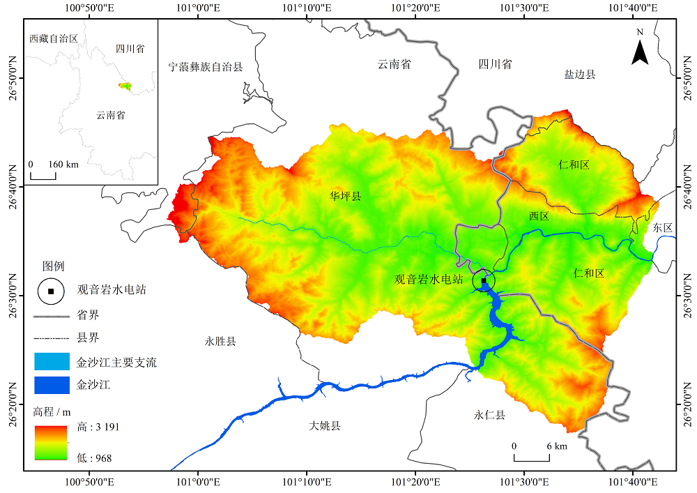
图1 研究区地理位置
Figure 1 Geographical location of the studied area
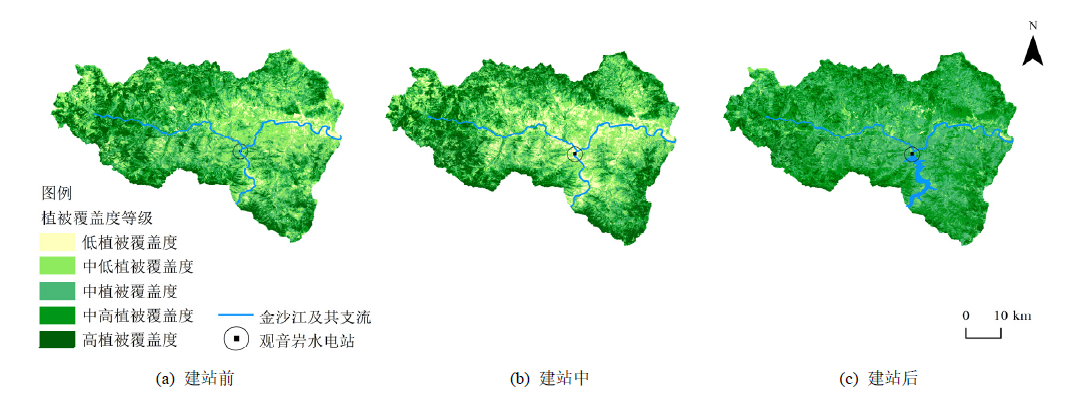
图2 研究区植被覆盖度等级
图3 Fraction Vegetation coverage grade in the studied area
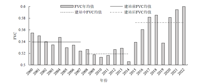
图3 2000-2022年研究区FVC均值年际变化
图3 Interannual variation of FVC in the study area from 2000 to 2022
| 植被覆盖度等级 | 建站前 | 建站中 | 建站后 |
|---|---|---|---|
| 低植被覆盖度 | 5.8 | 10.4 | 1.32 |
| 中低植被覆盖度 | 30.1 | 29.5 | 7.15 |
| 中植被覆盖度 | 26.7 | 22.1 | 38.5 |
| 中高植被覆盖度 | 22.6 | 20.7 | 43.4 |
| 高植被覆盖度 | 14.8 | 17.3 | 9.63 |
表1 研究区FVC各等级面积占比
Table 1 The proportion of FVC in different grades in the study area %
| 植被覆盖度等级 | 建站前 | 建站中 | 建站后 |
|---|---|---|---|
| 低植被覆盖度 | 5.8 | 10.4 | 1.32 |
| 中低植被覆盖度 | 30.1 | 29.5 | 7.15 |
| 中植被覆盖度 | 26.7 | 22.1 | 38.5 |
| 中高植被覆盖度 | 22.6 | 20.7 | 43.4 |
| 高植被覆盖度 | 14.8 | 17.3 | 9.63 |
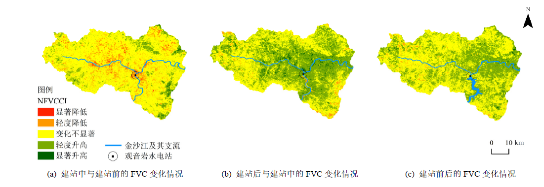
图4 NFVCCI分区图
Figure 4 NFVCCI zoning map
| 等级 | 建站中与建站前 | 建站后与建站中 | 建站前后 |
|---|---|---|---|
| 显著降低 | 1.05 | 0.02 | 0.03 |
| 轻度降低 | 10.5 | 2.33 | 2.3 |
| 变化不显著 | 77.1 | 45.5 | 56.4 |
| 轻度升高 | 10.9 | 48.8 | 40.4 |
| 显著升高 | 0.45 | 3.35 | 0.78 |
表2 研究区NFVCCI面积占比
Table 2 The proportion of NFVCCI area in the studied area %
| 等级 | 建站中与建站前 | 建站后与建站中 | 建站前后 |
|---|---|---|---|
| 显著降低 | 1.05 | 0.02 | 0.03 |
| 轻度降低 | 10.5 | 2.33 | 2.3 |
| 变化不显著 | 77.1 | 45.5 | 56.4 |
| 轻度升高 | 10.9 | 48.8 | 40.4 |
| 显著升高 | 0.45 | 3.35 | 0.78 |
| 地理影响 因子 | 等级 | 分级标准 | NFVCCI分区 | |
|---|---|---|---|---|
| 变化不显著 | 轻度升高 | |||
| 地表温度 | 1 | 0.190‒27.1 ℃ | 8.5% | 6% |
| 2 | 27.1‒32.6 ℃ | 33.3% | 30.1% | |
| 3 | 32.6‒36.8 ℃ | 36.3% | 42.1% | |
| 4 | 36.8-63.7 ℃ | 21.9% | 21.8% | |
| 降水量 | 1 | <775 mm | 39.2% | 33% |
| 2 | 775‒796 mm | 30.6% | 34.5% | |
| 3 | 796‒827 mm | 21% | 19.7% | |
| 4 | >827 mm | 9.2% | 12.8% | |
| 高程 | 1 | <1448 m | 23.2% | 40% |
| 2 | 1448‒1817 m | 35.7% | 25% | |
| 3 | 1817‒2218 m | 27.5% | 19.8% | |
| 4 | >2218 m | 13.6% | 15.2% | |
| 坡度 | 平地 | <3° | 1.71% | 1.7% |
| 缓坡 | 3°‒25° | 70.6% | 78.5% | |
| 中坡 | 25°‒45° | 27.1% | 19.4% | |
| 陡坡 | >45° | 0.59% | 0.4% | |
| 坡向 | 阳坡 | 东南、南、西南、西 | 47.6% | 60.6% |
| 平面 | 平面 | 0.1% | 0.1% | |
| 阴坡 | 西北、北、东北、东 | 52.3% | 39.3% | |
| 距河流距离 | 1 | <1000 m | 4.9% | 9.2% |
| 2 | 1000‒3000 m | 10.1% | 17.9% | |
| 3 | 3000‒9000 m | 35% | 38.5% | |
| 4 | >9000 m | 50% | 34.4% | |
表3 地理影响因子等级划分及与NFVCCI各区域占比统计表
Table 3 Statistics on the classification of geographical influencing factors and the percentage of each region in the NFVCCI
| 地理影响 因子 | 等级 | 分级标准 | NFVCCI分区 | |
|---|---|---|---|---|
| 变化不显著 | 轻度升高 | |||
| 地表温度 | 1 | 0.190‒27.1 ℃ | 8.5% | 6% |
| 2 | 27.1‒32.6 ℃ | 33.3% | 30.1% | |
| 3 | 32.6‒36.8 ℃ | 36.3% | 42.1% | |
| 4 | 36.8-63.7 ℃ | 21.9% | 21.8% | |
| 降水量 | 1 | <775 mm | 39.2% | 33% |
| 2 | 775‒796 mm | 30.6% | 34.5% | |
| 3 | 796‒827 mm | 21% | 19.7% | |
| 4 | >827 mm | 9.2% | 12.8% | |
| 高程 | 1 | <1448 m | 23.2% | 40% |
| 2 | 1448‒1817 m | 35.7% | 25% | |
| 3 | 1817‒2218 m | 27.5% | 19.8% | |
| 4 | >2218 m | 13.6% | 15.2% | |
| 坡度 | 平地 | <3° | 1.71% | 1.7% |
| 缓坡 | 3°‒25° | 70.6% | 78.5% | |
| 中坡 | 25°‒45° | 27.1% | 19.4% | |
| 陡坡 | >45° | 0.59% | 0.4% | |
| 坡向 | 阳坡 | 东南、南、西南、西 | 47.6% | 60.6% |
| 平面 | 平面 | 0.1% | 0.1% | |
| 阴坡 | 西北、北、东北、东 | 52.3% | 39.3% | |
| 距河流距离 | 1 | <1000 m | 4.9% | 9.2% |
| 2 | 1000‒3000 m | 10.1% | 17.9% | |
| 3 | 3000‒9000 m | 35% | 38.5% | |
| 4 | >9000 m | 50% | 34.4% | |
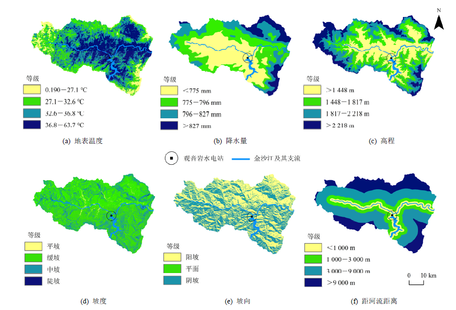
图5 地理影响因子分级与建站前后FVC变化对比图
Figure 5 Classification of geographical influencing factors and comparison chart of FVC changes before and after the construction of the station
| 时期 | 影响因素 | 系数 | t统计量 | Robust_Pr | VIF | AICc | 校正r2 | Koenker (BP) |
|---|---|---|---|---|---|---|---|---|
| 建站前 | 地表温度 | −1.28 | −35.5 | 0.00* | 1.88 | −4818 | 0.59 | 338 |
| 降水量 | −0.50 | −28.3 | 0.00* | 2.88 | ||||
| 高程 | 0.19 | 10.3 | 0.00* | 3.52 | ||||
| 坡度 | 0.40 | 14.2 | 0.00* | 1.11 | ||||
| 坡向 | −0.22 | −11 | 0.00* | 1.11 | ||||
| 距河流距离 | 0.14 | 19.3 | 0.00* | 1.73 | ||||
| 建站中 | 地表温度 | −0.51 | −16 | 0.00* | 1.56 | −4049 | 0.62 | 150 |
| 降水量 | −0.06 | −2.9 | 0.00* | 2.83 | ||||
| 高程 | 0.41 | 19.6 | 0.00* | 3.19 | ||||
| 坡度 | 0.60 | 18.5 | 0.00* | 1.14 | ||||
| 坡向 | −0.06 | −3.73 | 0.00* | 1.08 | ||||
| 距河流距离 | 0.15 | 18.3 | 0.00* | 1.72 | ||||
| 建站后 | 地表温度 | 0.11 | 3.16 | 0.00* | 3.18 | −6638 | 0.39 | 485 |
| 降水量 | −0.12 | −11.2 | 0.00* | 2.03 | ||||
| 高程 | 0.22 | 16.1 | 0.00* | 4.09 | ||||
| 坡度 | 0.32 | 17.3 | 0.00* | 1.17 | ||||
| 坡向 | −0.01 | −0.03 | 0.00* | 1.10 | ||||
| 距河流距离 | 0.12 | 14.3 | 0.00* | 1.77 |
表4 研究区植被覆盖度及其地理影响因子OLS结果汇总
Table 4 Summary of OLS results for vegetation cover and its geographical influencing factors in the studied area
| 时期 | 影响因素 | 系数 | t统计量 | Robust_Pr | VIF | AICc | 校正r2 | Koenker (BP) |
|---|---|---|---|---|---|---|---|---|
| 建站前 | 地表温度 | −1.28 | −35.5 | 0.00* | 1.88 | −4818 | 0.59 | 338 |
| 降水量 | −0.50 | −28.3 | 0.00* | 2.88 | ||||
| 高程 | 0.19 | 10.3 | 0.00* | 3.52 | ||||
| 坡度 | 0.40 | 14.2 | 0.00* | 1.11 | ||||
| 坡向 | −0.22 | −11 | 0.00* | 1.11 | ||||
| 距河流距离 | 0.14 | 19.3 | 0.00* | 1.73 | ||||
| 建站中 | 地表温度 | −0.51 | −16 | 0.00* | 1.56 | −4049 | 0.62 | 150 |
| 降水量 | −0.06 | −2.9 | 0.00* | 2.83 | ||||
| 高程 | 0.41 | 19.6 | 0.00* | 3.19 | ||||
| 坡度 | 0.60 | 18.5 | 0.00* | 1.14 | ||||
| 坡向 | −0.06 | −3.73 | 0.00* | 1.08 | ||||
| 距河流距离 | 0.15 | 18.3 | 0.00* | 1.72 | ||||
| 建站后 | 地表温度 | 0.11 | 3.16 | 0.00* | 3.18 | −6638 | 0.39 | 485 |
| 降水量 | −0.12 | −11.2 | 0.00* | 2.03 | ||||
| 高程 | 0.22 | 16.1 | 0.00* | 4.09 | ||||
| 坡度 | 0.32 | 17.3 | 0.00* | 1.17 | ||||
| 坡向 | −0.01 | −0.03 | 0.00* | 1.10 | ||||
| 距河流距离 | 0.12 | 14.3 | 0.00* | 1.77 |
| 时期 | 影响因素 | 最大值 | 最小值 | AICc | r2 | 校正r2 |
|---|---|---|---|---|---|---|
| 建站前 | 地表温度 | −0.03 | −2.57 | −6988 | 0.85 | 0.83 |
| 降水量 | 1.64 | −1.99 | ||||
| 高程 | 1.25 | −2.00 | ||||
| 坡度 | 1.18 | −0.49 | ||||
| 坡向 | 0.20 | −0.74 | ||||
| 距河流距离 | 0.97 | −0.36 | ||||
| 建站中 | 地表温度 | 0.28 | −4.22 | −6556 | 0.88 | 0.87 |
| 降水量 | 1.48 | −2.31 | ||||
| 高程 | 1.95 | −1.22 | ||||
| 坡度 | 1.16 | −0.58 | ||||
| 坡向 | 0.26 | −0.44 | ||||
| 距河流距离 | 0.55 | −0.39 | ||||
| 建站后 | 地表温度 | 1.73 | −2.11 | −9552 | 0.84 | 0.81 |
| 降水量 | 0.51 | −1.60 | ||||
| 高程 | 1.53 | −0.84 | ||||
| 坡度 | 0.89 | −0.19 | ||||
| 坡向 | 0.29 | −0.21 | ||||
| 距河流距离 | 0.34 | −0.23 |
表5 研究区植被覆盖度及其地理影响因子GWR结果汇总
Table 5 Summary of GWR results for vegetation cover and its geographical influencing factors in the studied area
| 时期 | 影响因素 | 最大值 | 最小值 | AICc | r2 | 校正r2 |
|---|---|---|---|---|---|---|
| 建站前 | 地表温度 | −0.03 | −2.57 | −6988 | 0.85 | 0.83 |
| 降水量 | 1.64 | −1.99 | ||||
| 高程 | 1.25 | −2.00 | ||||
| 坡度 | 1.18 | −0.49 | ||||
| 坡向 | 0.20 | −0.74 | ||||
| 距河流距离 | 0.97 | −0.36 | ||||
| 建站中 | 地表温度 | 0.28 | −4.22 | −6556 | 0.88 | 0.87 |
| 降水量 | 1.48 | −2.31 | ||||
| 高程 | 1.95 | −1.22 | ||||
| 坡度 | 1.16 | −0.58 | ||||
| 坡向 | 0.26 | −0.44 | ||||
| 距河流距离 | 0.55 | −0.39 | ||||
| 建站后 | 地表温度 | 1.73 | −2.11 | −9552 | 0.84 | 0.81 |
| 降水量 | 0.51 | −1.60 | ||||
| 高程 | 1.53 | −0.84 | ||||
| 坡度 | 0.89 | −0.19 | ||||
| 坡向 | 0.29 | −0.21 | ||||
| 距河流距离 | 0.34 | −0.23 |

图6 建站前、建站中、建站后FVC及其地理影响因子GWR回归系数
Figure 6 GWR regression coefficients of FVC and its geographical influencing factors before, during and after hydropower station construction
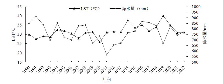
图7 2000-2022年研究区地表温度、降水量均值年际变化
Figure 7 Inter-annual changes in mean land surface temperature and precipitation values in the studied area from 2000 to 2022
| [1] | ANEES S A, ZHANG X L, SHAKEEL M, et al., 2022. Estimation of fractional vegetation cover dynamics based on satellite remote sensing in Pakistan: A comprehensive study on the FVC and its drivers[J]. Journal of King Saud University-Science, 34(6): 101848. |
| [2] | BRUNSDON C, FOTHERINGHAM A S, CHARLTON M E, 1996. Geographically weighted regression: A method for exploring spatial non-stationarity[J]. Geographical Analysis, 28(4): 281-298. |
| [3] | ERMIDA S L, SOAREA P, MANTAS V, et al., 2020. Google Earth Engine open-source code for land surface temperature estimation from the Landsat series[J]. Remote Sensing, 12(9):1471. |
| [4] | HUANG Z W, LI S Y, PENG Y H, et al., 2023. Spatial non-stationarity of influencing factors of China’s county economic development base on a multiscale geographically weighted regression model[J]. ISPRS International Journal of Geo-Information, 12(3): 109. |
| [5] | JIA K, LIANG S L, ZHANG L, et al., 2014. Forest cover classification using Landsat ETM+ data and time series MODIS NDVI data[J]. International Journal of Applied Earth Observation and Geoinformation, 33: 32-38. |
| [6] | LIU S S, LIAO Q P, XIAO M Z, et al., 2022. Spatial and temporal variations of Habitat Quality and its response of landscape dynamic in the Three Gorges Reservoir area, China[J]. International Journal of Environmental Research and Public Health, 19(6): 3594. |
| [7] | LIU Y, HUANG T T, QIU Z Y, et al., 2024. Effects of precipitation changes on fractional vegetation cover in the Jinghe River basin from 1998 to 2019[J]. Ecological Informatics, 80: 102505. |
| [8] | MAMATTURSUN A, YANG H, ABLIKIM K, et al., 2022. Spatio-temporal evolution and driving forces of vegetation cover in the Urumqi River basin[J]. International Journal of Environmental Research and Public Health, 19(22): 15323. |
| [9] | OBAID A, ADAM E, ALI K A, 2023. Land use and land cover change in the Vaal Dam Catchment, South Africa: A study based on Remote Sensing and time series analysis[J]. Geomatics, 3(1): 205-220. |
| [10] | TIAN M Q, ZHOU J Z, JIA B J, et al., 2020. Impact of Three Gorges Reservoir water impoundment on vegetation-climate response relationship[J]. Remote Sensing, 12(17): 2860. |
| [11] | WANG D C, WANG F C, HUANG Y, et al., 2018. Examining the effects of hydropower station construction on the surface temperature of the Jinsha River dry-hot valley at different seasons[J]. Remote Sensing, 10(4): 600. |
| [12] | WANG D C, ZHANG X, HUANG Y, et al., 2021. Comparative study on temperature response of hydropower development in the Dry-Hot Valley[J]. GeoHealth, 5(7): e2021GH000438. |
| [13] | YAO B, MA L, SI H T, et al., 2023. Spatial pattern of changing vegetation dynamics and its driving factors across the Yangtze River basin in Chongqing: A geodetector-based study[J]. Land, 12(2): 269. |
| [14] | ZHAO Q H, LIU S L, DENG L, et al., 2013. Determining the influencing distance of dam construction and reservoir impoundment on land use: A case study of Manwan Dam, Lancang River[J]. Ecological engineering, 53: 235-242. |
| [15] | 陈浩, 权倍平, 李占斌, 等, 2024. 北洛河上游流域植被覆盖度时空变化及其地形分异特征[J]. 水土保持研究, 31(2): 219-227, 239. |
| CHEN H, QUAN B P, LI Z B, et al., 2024. Spatio-temporal changes of vegetation coverage and its topographic differentiation characteristics in the upper reaches of Beiluo River watershed[J]. Research of Soil and Water Conservation, 31(2): 219-227, 239. | |
| [16] |
程东亚, 李旭东, 2019. 喀斯特地区植被覆盖度变化及地形与人口效应研究[J]. 地球信息科学学报, 21(8): 1227-1239.
DOI |
| CHENG Y D, LI X D, 2019. Vegetation coverage change in a Karst Area and effects of terrain and population[J]. Journal of Geo-information Science, 21(8): 1227-1239. | |
| [17] | 崔红婧, 褚琳, 尹雅琦, 等, 2024. 1990-2020年三峡库区植被物候时空格局及其演变机制[J]. 生态学报, 44(9): 1-16. |
| CUI H J, CHU L, YIN Y Q, et al., 2024. Spatio-temporal patterns of vegetation phenology and their evolutionary mechanisms in the Three Gorges Reservoir Area from 1990 to 2020[J]. Acta Ecologica Sinica, 44(9): 1-16. | |
| [18] |
龚围, 李丽, 柳钦火, 等, 2020. “一带一路” 区域水电站工程生态环境影响遥感监测[J]. 地球信息科学学报, 22(7): 1424-1436.
DOI |
| GONG W, LI L, LIU Q H, et al., 2020. Monitoring and analyzing ecosystem impact on hydropower projects by Remote Sensing in the Belt and Road Region[J]. Journal of Geo-information Science, 22(7): 1424-1436. | |
| [19] | 胡砚霞, 黄进良, 杜耘, 等, 2018. 2000-2015年丹江口库区植被覆盖时空变化趋势及其成因分析[J]. 长江流域资源与环境, 27(4): 862-872. |
| HU Y X, HUANG J L, DU Y, et al., 2018. Spatio-temporal trends of vegetation coverage and their causes in the Danjiangkou Reservoir region during 2000 to 2015[J]. Resources and Environment in the Yangtze Basin, 27(4): 862-872. | |
| [20] | 江维薇, 查子霞, 肖衡林, 2024. 金沙江观音岩水库消落带绝对优势植物的表型可塑性与适应策略[J]. 湖泊科学, 36(1): 261-273. |
| JIANG W W, ZHA Z X, XIAO H L, 2024. Phenotypic plasticity and adaptation strategies of dominant plants in the water-level-fluctuating zone of Guanyinyan Reservoir, Jinsha River[J]. Journal of Lake Sciences, 36(1): 261-273. | |
| [21] | 焦欢, 丁忆, 段松江, 等, 2022. 三峡库区植被覆盖度与地表温度的空间耦合季节分异研究[J]. 生态与农村环境学报, 38(12): 1604-1612. |
| JIAO H, DING Y, DUAN S J, et al., 2022. Study on spatial coupling seasonal differentiation of vegetation coverage and land surface temperature in the Three Gorges Reservoir area[J]. Journal of Ecology and Rural Environment, 38(12): 1604-1612. | |
| [22] | 寇杰锋, 杨超, 张莹莹, 等, 2024. 黄河中下游伊洛河流域2002-2021年植被覆盖度时空变化及影响因素分析[J]. 灌溉排水学报, 43(1): 89-96. |
| KOU J F, YANG C, ZHANG Y Y, et al., 2024. Spatio-temporal variation of fractional vegetation cover and its influencing factors in the Yiluo River basin of the middle and lower reaches of the Yellow River from 2002 to 2021[J]. Journal of Irrigation and Drainage, 43(1): 89-96. | |
| [23] | 李苗苗, 2003. 植被覆盖度的遥感估算方法研究[D]. 北京: 中国科学院研究生院(遥感应用研究所):28. |
| LI M M, 2003. The method of vegetation fraction estimation by Remote Sensing[D]. Beijing: Chinese Academy of Sciences (Institute of Remote Sensing Application):28. | |
| [24] | 廖清飞, 2014. 青海省东部农业区干旱遥感模型研究[D]. 咸阳: 西北农林科技大学:27. |
| LIAO Q F, 2014. Study of drought Remote Sensing model in eastern agricultural region of Qinghai Province[D]. Xianyang: Northwest A & F University: 27. | |
| [25] | 马志勇, 沈涛, 张军海, 等, 2007. 基于植被覆盖度的植被变化分析[J]. 测绘通报 (3): 45-48. |
| MA Z Y, SHEN T, ZHANG J H, et al., 2007. Vegetation changes analysis based on vegetation coverage[J]. Bulletin of Surveying and Mapping (3): 45-48. | |
| [26] |
庞瑞秋, 腾飞, 魏冶, 2014. 基于地理加权回归的吉林省人口城镇化动力机制分析[J]. 地理科学, 34(10): 1210-1217.
DOI |
| PANG R Q, TENG F, WEI Z, 2014. A GWR-based study on dynamic mechanism of population urbanization in Jilin Province[J]. Scientia Geographica Sinica, 34(10): 1210-1217. | |
| [27] | 孙洪波, 杨桂山, 苏伟忠, 等, 2010. 沿江地区土地利用生态风险评价——以长江三角洲南京地区为例[J]. 生态学报, 30(20): 5616-5625. |
| SUN H B, YANG G S, SU W Z, et al., 2010. Ecological risk assessment of land use in the area along Changjiang River: A case study of Nanjing, China[J]. Acta Ecologica Sinica, 30(20): 5616-5625. | |
| [28] | 唐达, 张习传, 陈凡, 等, 2023. 高寒地区水电开发植被恢复策略探讨[J]. 中国水土保持 (11): 47-50. |
| TANG D, ZHANG X C, CHEN F, et al., 2023. Vegetation restoration strategies for hydropower development in Alpine areas[J]. Soil and Water Conservation in China (11): 47-50. | |
| [29] | 童新华, 何彦谚, 韦燕飞, 2020. 广西贫困时空分异格局与影响机制分析[J]. 地域研究与开发, 39(1): 32-38. |
| TONG X H, HE Y Y, WEI Y F, 2020. Analysis of spatial-temporal distribution pattern and influence mechanism of Poverty in Guangxi[J]. Areal Research and Development, 39(1): 32-38. | |
| [30] | 童晓伟, 王克林, 岳跃民, 等, 2014. 桂西北喀斯特区域植被变化趋势及其对气候和地形的响应[J]. 生态学报, 34(12): 3425-3434. |
| TONG X W, WANG K L, YUE Y M, et al., 2014. Trends in vegetation and their responses to climate and topography in northwest Guangxi[J]. Acta Ecologica Sinica, 34(12): 3425-3434. | |
| [31] | 汪东川, 俞长锦, 孙苗苗, 等, 2024. 金沙江干热河谷典型水电开发对局地气候的影响[J]. 水土保持学报, 38(1): 158-166. |
| WANG D C, YU C J, SUN M M, et al., 2024. Impacts of typical hydropower development on local climate in the dry-hot valley of the Jinsha River[J]. Journal of Soil and Water Conservation, 38(1): 158-166. | |
| [32] | 杨逢春, 毛晓叶, 刘景欣, 等, 2020. 元江干热河谷主要环境因子(气温和降水)变化规律及蕨类植物的分布响应[J]. 热带亚热带植物学报, 28(6): 537-546. |
| YANG F C, MAO X Y, LIU J X, et al., 2020. Variation of major environmental factors (temperature and precipitation) in Yuanjiang dry-hot valley and the response of pteridophytes[J]. Journal of Tropical and Subtropical Botany, 28(6): 537-546. | |
| [33] | 杨凯祥, 刘强, 李秀红, 等, 2021. 三峡库区土壤侵蚀和植被覆盖变化分析[J]. 北京师范大学学报(自然科学版), 57(5): 631-638. |
| YANG K X, LIU Q, LI X H, et al., 2021. Analysis of soil erosion and vegetation cover change in Three Gorges Reservoir area[J]. Journal of Beijing Normal University (Natural Science), 57(5): 631-638. | |
| [34] | 张晓虹, 何有华, 胡彦婷, 2020. 干旱风沙区水库边缘植被-风力侵蚀的变化及成因[J]. 水土保持通报, 40(6): 1-7, 22. |
| ZHANG X H, HE Y H, HU Y T, 2020. Evolution and causes of vegetation and wind erosion at reservoir edge in arid sandstorm area[J]. Bulletin of Soil and Water Conservation, 40(6): 1-7, 22. | |
| [35] | 张顾萍, 陈国民, 邵怀勇, 等, 2021. 近16年金沙江流域植被覆盖时空特征及其对气候的响应[J]. 长江流域资源与环境, 30(7): 1638-1648. |
| ZHANG G P, CHEN G M, SHAO H Y, 2021. Spatial-temporal characteristics of vegetation coverage and its response to climate from 2000 to 2015 in Jinsha River basin, China[J]. Resources and Environment in the Yangtze Basin, 30(7): 1638-1648. | |
| [36] | 赵冬林, 朱仕荣, 2024. 2010-2021年金沙江干热河谷植被覆盖度时空变化及其影响因素[J/OL]. 生态学杂志, 1-11 [2024-03-14]. http://kns.cnki.net/kcms/detail/21.1148.Q.20231122.0947.002.html. |
| ZHAO D L, ZHU S R, 2024. Spatio-temporal variation of vegetation coverage and its influencing factors in the dry-hot valley of Jinsha River during 2010-2021[J/OL]. Chinese Journal of Ecology, 1-12 [2024-04-10]. http://kns.cnki.net/kcms/detail/10.1746.TV.20231023.1100.004.html. | |
| [37] | 赵旭, 王浩, 赵志龙, 等, 2024. 金沙江下游梯级水电工程库区生态系统服务价值演化及权衡协同关系[J]. 生态与农村环境学报, 40(1): 44-54. |
| ZHAO X, WANG H, ZHAO Z L, et al., 2024. Evolution and tradeoff synergy relationship of ecosystem services value in cascade hydropower project reservoir area of the lower reaches of Jinsha River[J]. Journal of Ecology and Rural Environment, 40(1): 44-54. | |
| [38] | 中华人民共和国水利部,2008. 土壤侵蚀分类分级标准: SL190—2007 [S]. 北京: 中国水利水电出版社: 9. |
| Ministry of Water Resources of the People’s Republic of China, 2008. Standards for Classification and Gradation of Soil Erosion: SL 190—2007 [S]. Beijing: China Water & Power Press: 9. | |
| [39] | 周美林, 刘家宏, 刘希胜, 等, 2024. 青海湖流域植被动态变化驱动力及空间粒度效应[J]. 中国环境科学, 44(3): 1497-1506. |
| ZHOU M L, LIU J H, LIU X S, et al., 2024. Analysis of driving forces and spatial scale effects on vegetation dynamics in the Qinghai Lake Basin[J]. China Environmental Science, 44(3): 1497-1506. | |
| [40] | 周婕, 张珂, 杜涛, 2024. 基于卫星遥感的水库库区植被覆盖变化研究: 以三河口水库为例[J/OL]. 水利水电技术(中英文), 1-12 [2024-04-10]. http://kns.cnki.net/kcms/detail/10.1746.TV.20231023.1100.004.html. |
| ZHOU J, ZHANG K, DU T, 2024. Research on vegetation cover variations in reservoir areas based on satellite remote sensing: A case study of Sanhekou Reservoir area[J/OL]. Water Resources and Hydropower Engineering, 1-12 [2024-04-10]. http://kns.cnki.net/kcms/detail/10.1746.TV.20231023.1100.004.html. | |
| [41] | 周雪妮, 肖成志, 刘磊, 等, 2024. 2000-2020年岷江上游干旱河谷区植被时空变化及其地形效应[J/OL]. 现代地质, 1-10 [2024-05-31]. https://doi.org/10.19657/j.geoscience.1000-8527.2024.034. |
| ZHOU X N, XIAO C Z, LIU L, et al., 2024. Spatial and temporal changes of vegetation and its topographic effects in the arid valley area of the upper reaches of Minjiang River from 2000 to 2020[J/OL]. Geoscience, 1-10 [2024-05-31]. https://doi.org/10.19657/j.geoscience.1000-8527.2024.034. |
| [1] | 徐佳乐, 杨兴川, 赵文吉, 杨志强, 钟一雪, 师乐颜, 马鹏飞. 气候变化背景下内蒙古中西部植被覆盖度演变特征研究[J]. 生态环境学报, 2024, 33(7): 1008-1018. |
| [2] | 宋小龙, 马明德, 王鹏, 李陇堂, 米文宝, 宋永永. 2000—2022年宁夏不同地理分区生长季植被覆盖度时空非平稳性特征[J]. 生态环境学报, 2024, 33(6): 853-868. |
| [3] | 陈晓辉, 胡喜生. 耦合ER和GWR的福州市生态环境质量的驱动力分析[J]. 生态环境学报, 2024, 33(5): 812-823. |
| [4] | 张鐥文, 杨冉, 侯文星, 王丽丽, 刘爽, 宋汉扬, 赵文吉, 李令军. 生态补水前后永定河两岸植被覆盖度变化及驱动力分析[J]. 生态环境学报, 2023, 32(2): 264-273. |
| [5] | 郑晓豪, 陈颖彪, 郑子豪, 郭城, 黄卓男, 周泳诗. 湖北省生态系统服务价值动态变化及其影响因素演变[J]. 生态环境学报, 2023, 32(1): 195-206. |
| [6] | 李梦华, 韩颖娟, 赵慧, 王云霞. 基于地理探测器的宁夏植被覆盖度时空变化特征及其驱动因子分析[J]. 生态环境学报, 2022, 31(7): 1317-1325. |
| [7] | 王瑞璠, 魏倪彬, 张仓皓, 鲍甜甜, 刘健, 余坤勇, 王帆. 南方丘陵区林下植被覆盖度无人机多角度遥感测量[J]. 生态环境学报, 2021, 30(12): 2294-2302. |
| 阅读次数 | ||||||
|
全文 |
|
|||||
|
摘要 |
|
|||||