生态环境学报 ›› 2022, Vol. 31 ›› Issue (5): 999-1007.DOI: 10.16258/j.cnki.1674-5906.2022.05.015
李喆( ), 陈圣宾*(), 陈芝阳
收稿日期:2021-12-12
出版日期:2022-05-18
发布日期:2022-07-12
通讯作者:
* 陈圣宾(1979年生),男,副研究员,研究方向为生态系统退化机理、修复技术与模式生物多样性的时空格局、形成机制与系统保护生态大数据理论、方法与应用。E-mail: chainpin@126.com作者简介:李喆(1996年生),女,硕士研究生,研究方向为城市热环境。E-mail: 651452144@qq.com
LI Zhe(), CHEN Shengbin*(), CHEN Zhiyang
Received:2021-12-12
Online:2022-05-18
Published:2022-07-12
摘要:
不同土地利用类型对城市地表温度具有不同的影响。目前关于地表温度与土地利用类型间的空间自相关性、双变量空间相关性的研究缺乏系统的尺度效应探讨。以成都市为例,利用遥感与GIS方法获取研究区2010—2021年间冬夏两季共6期遥感影像的地表温度、NDBI、NDVI和NDWI数据,运用半变异函数识别其在不同年份下的空间相关性分析尺度,并结合Moran’s I值分析地表温度与各土地利用类型间的空间相关性,试图揭示两者之间的相关性的空间尺度依赖规律,及其空间变异特点,为合理规划与建设城市蓝绿系统,减弱城市热岛效应,改善城市生态环境提供重要参考。研究发现,(1)研究区在冬夏两季均表现出明显的热岛效应,NDBI、NDWI值均表现为中心高四周低,NDVI值表现为中心低四周高。(2)LST、NDBI、NDVI、NDWI的单变量空间自相关性存在明显的尺度效应,300 m尺度范围内自相关性尺度效应变化明显,300—600 m尺度范围内自相关性尺度效应减弱。夏季的LST单变量空间自相关性最强,NDVI与NDWI整体上表现出夏季自相关性尺度大于冬季。(3)LST与各地表参数间双变量空间相关性尺度均在300 m左右,300 m尺度范围内,尺度效应明显,整体表现为夏季的相关性大于冬季。(4)LST与3种土地利用类型存在密切关系。该研究结果对于进一步认识LST与土地利用类型间的空间相关性的尺度效应具有推动作用。
中图分类号:
李喆, 陈圣宾, 陈芝阳. 地表温度与土地利用类型间的空间尺度依赖性——以成都为例[J]. 生态环境学报, 2022, 31(5): 999-1007.
LI Zhe, CHEN Shengbin, CHEN Zhiyang. Spatial Scale Dependence between Land Surface Temperature and Land Use Types: A Case Study of Chengdu City[J]. Ecology and Environment, 2022, 31(5): 999-1007.
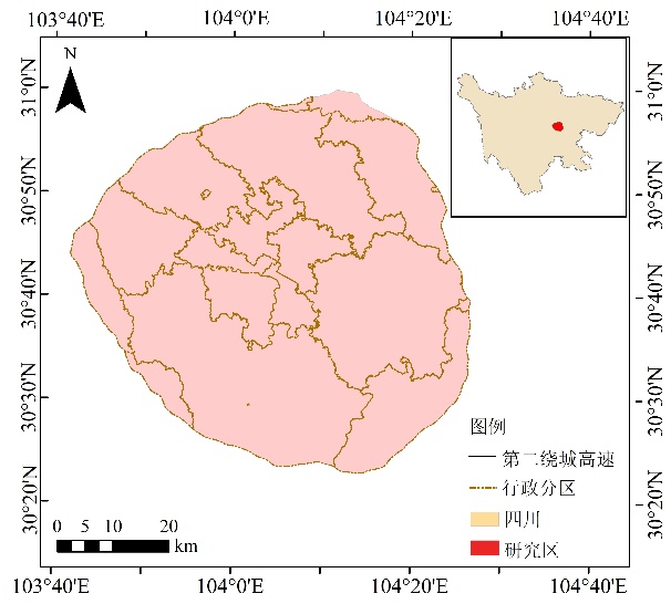
图1 研究区概况
Figure 1 Overview of the study area
| 序号 Serial number | 成像时间 Imaging time | τ | 大气上行辐射亮度 Atmospheric Upper Row radiance/ (W∙m-2∙µm-1∙sr-1) | 大气下行辐射亮度 Atmospheric downgradient radiance/ (W∙m-2∙µm-1∙sr-1) |
|---|---|---|---|---|
| 1 | 2010-12-22 | 0.9 | 0.57 | 0.97 |
| 2 | 2014-12-19 | 0.94 | 0.38 | 0.65 |
| 3 | 2016-09-11 | 0.65 | 2.66 | 4.23 |
| 4 | 2018-06-05 | 0.72 | 2.32 | 3.73 |
| 5 6 | 2019-08-11 2021-02-25 | 0.66 0.89 | 2.99 0.72 | 4.73 1.23 |
表1 影像基本信息
Table 1 Basic image information
| 序号 Serial number | 成像时间 Imaging time | τ | 大气上行辐射亮度 Atmospheric Upper Row radiance/ (W∙m-2∙µm-1∙sr-1) | 大气下行辐射亮度 Atmospheric downgradient radiance/ (W∙m-2∙µm-1∙sr-1) |
|---|---|---|---|---|
| 1 | 2010-12-22 | 0.9 | 0.57 | 0.97 |
| 2 | 2014-12-19 | 0.94 | 0.38 | 0.65 |
| 3 | 2016-09-11 | 0.65 | 2.66 | 4.23 |
| 4 | 2018-06-05 | 0.72 | 2.32 | 3.73 |
| 5 6 | 2019-08-11 2021-02-25 | 0.66 0.89 | 2.99 0.72 | 4.73 1.23 |
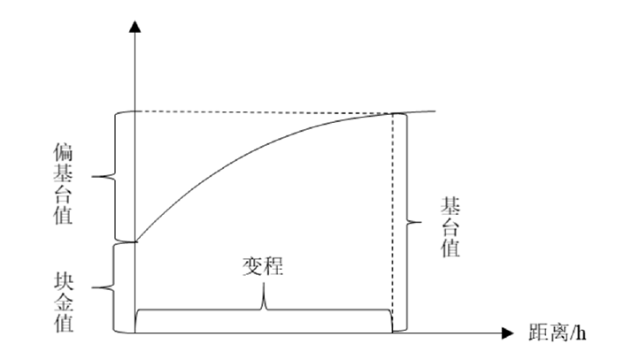
图2 半变异函数拟合曲线示例
Figure 2 An example curve of the semi-variogram function

图3 研究区LST、NDBI、NDVI、NDWI空间分布
Figure 3 Spatial distribution of the LST, NDBI, NDVI and NDWI in the study area
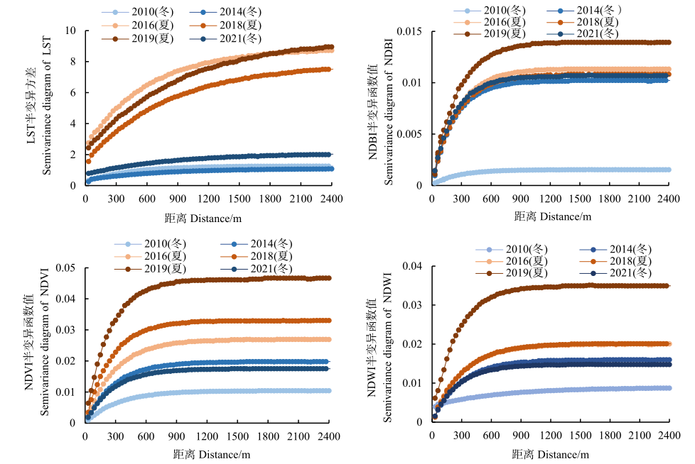
图4 研究区LST、NDBI、NDVI、NDWI的半变异函数图
Figure 4 Semi-variograms of LST, NDBI, NDVI and NDWI in the study area
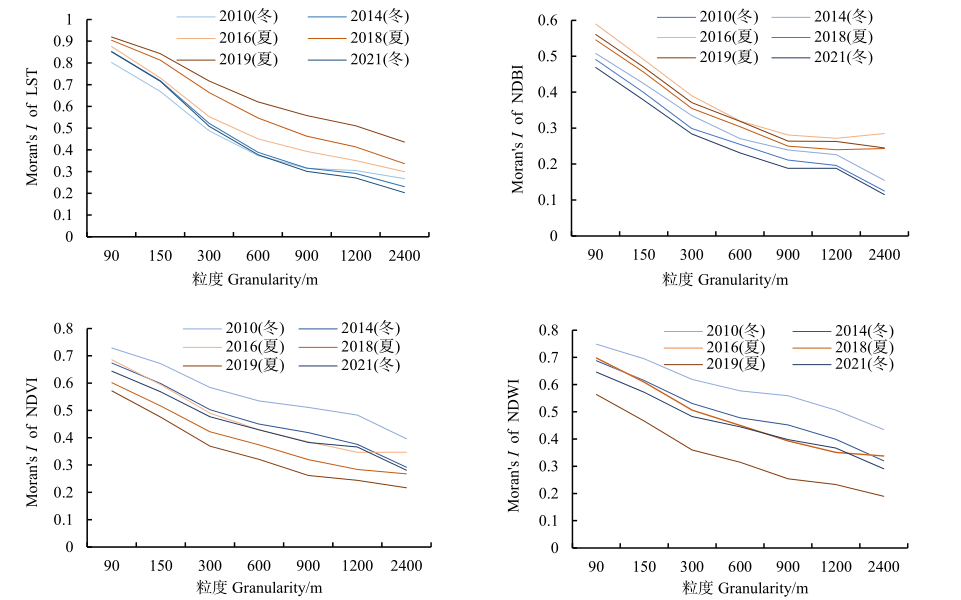
图5 LST、NDBI、NDVI、NDWI的空间自相关性的尺度效应
Figure 5 Scale effects of spatial autocorrelation of LST, NDBI, NDVI and NDWI in different years
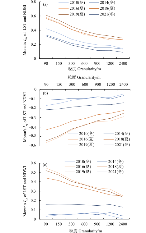
图6 不同年份下LST与土地利用类型的空间相关性的尺度效应
Figure 6 The spatial correlation between LST and land use classification in different years
| [1] |
COSEO P, LARSEN L, 2014. How factors of land use/land cover, building configuration, and adjacent heat sources and sinks explain Urban Heat Islands in Chicago[J]. Landscape and Urban Planning, 125: 117-129.
DOI URL |
| [2] | GALLO K P, MCNAB A L, KARL T R, et al., 1993. The use of a vegetation index for assessment of the urban heat island effect[J]. International Journal of Remote Sensing, 14: 11. |
| [3] | HUANG L P, MIAO J F, LIU Y K, 2012. Spatial and temporal variation characteristics of urban heat island in Tianjin[J]. Transactions of Atmospheric Sciences, 35(5): 620-632. |
| [4] |
KOKO A F, YUE W, ABUBAKAR G A, et al., 2021. Spatiotemporal Influence of Land Use/Land Cover Change Dynamics on Surface Urban Heat Island: A Case Study of Abuja Metropolis, Nigeria[J]. Isprs International Journal of Geo-Information, 10(5): 272.
DOI URL |
| [5] |
KONG L, LAU K K L, YUAN C, et al., 2017. Regulation of outdoor thermal comfort by trees in Hong Kong[J]. Sustainable Cities and Society, 31: 12-25.
DOI URL |
| [6] |
MAIMAITIYIMING M, GHULAM A, TIYIP T, et al., 2014. Effects of green space spatial pattern on land surface temperature: Implications for sustainable urban planning and climate change adaptation[J]. ISPRS Journal of Photogrammetry and Remote Sensing, 89: 59-66.
DOI URL |
| [7] | MORI K, KUROSU T, SHIOHIRA M, et al., 2009. Study on Relationship between Land Use/Cover and Urban Heat Island Based on Landsat ETM+Remote Sensing Data[J]. Journal of Fujian Normal University. Natural Science, 25(6): 106-113. |
| [8] |
OGASHAWARA I, BRUM BASTOS V D S, 2012. A Quantitative Approach for Analyzing the Relationship between Urban Heat Islands and Land Cover[J]. Remote Sensing, 4(11): 3596-3618.
DOI URL |
| [9] |
MEJIA-DOMINGUEZ N R, MEAVE J A, DÍAZ-ÁVALOS, 2012. Spatial structure of the abiotic environment and its association with sapling community structure and dynamics in a cloud forest[J]. International Journal of Biometeorology, 56(2): 305-318.
DOI URL |
| [10] |
RANI M, KUMAR P, PANDEY P C, et al., 2018. Multi-temporal NDVI and surface temperature analysis for Urban Heat Island inbuilt surrounding of sub-humid region: A case study of two geographical regions[J]. Remote Sensing Applications: Society and Environment, 10: 163-172.
DOI URL |
| [11] |
SCHATZ J, KUCHARIK C J, 2016. Urban heat island effects on growing seasons and heating and cooling degree days in Madison, Wisconsin USA[J]. International Journal of Climatology, 36(15): 4873-4884.
DOI URL |
| [12] |
SHAHFAHAD, KUMARI B, TAYYAB M, et al., 2020. Longitudinal study of land surface temperature (LST) using mono- and split-window algorithms and its relationship with NDVI and NDBI over selected metro cities of India[J]. Arabian Journal of Geosciences, 13(19): 3-329.
DOI URL |
| [13] |
THEEUWES N E, SOLCEROVÁ A, STEENEVELD G J, 2013. Modeling the influence of open water surfaces on the summertime temperature and thermal comfort in the city[J]. Journal of Geophysical Research-Atmospheres, 118(16): 8881-8896.
DOI URL |
| [14] | DEILAMI K, KAMRUZZAMAN M D, LIU Y, 2017. Urban heat island effect: A systematic review of spatio-temporal factors, data, methods, and mitigation measures[J]. International Journal of Applied Earth Observations and Geoinformation, 67: 30-42. |
| [15] |
WARTENBERG D, 1985. Multivariate spatialcorrelation: A method for exploratory geographical analysis[J]. Geographical Analysis, 17(4): 263-283.
DOI URL |
| [16] |
WU C Y, LI J X, WANG C F, et al., 2019. Understanding the relationship between urban blue infrastructure and land surface temperature[J]. Science of the Total Environment, 694: 133742.
DOI URL |
| [17] |
WU H, YE L P, SHI W Z, et al., 2014. Assessing the effects of land use spatial structure on urban heat islands using HJ-1B remote sensing imagery in Wuhan, China[J]. International Journal of Applied Earth Observation and Geoinformation, 32: 67-78.
DOI URL |
| [18] |
XIAO X D, DONG L, YAN H, et al., 2018. The influence of the spatial characteristics of urban green space on the urban heat island effect in Suzhou Industrial Park[J]. Sustainable Cities and Society, 40: 428-439.
DOI URL |
| [19] |
ZHAO X, LIU J J, BU Y K, 2021. Quantitative Analysis of Spatial Heterogeneity and Driving Forces of the Thermal Environment in Urban Built-up Areas: A Case Study in Xi’an, China[J]. Sustainability, 13(4): 1870-1870.
DOI URL |
| [20] | 柏延臣, 王劲峰, 2004. 基于特征统计可分性的遥感数据专题分类尺度效应分析[J]. 遥感技术与应用, 19(6): 443-449. |
| BO Y C, WANG J F, 2004. Exploring the scale effect in thematic classification of remotely sensed data: The statistical separability-based method[J]. Remote Sensing Technology and Application, 19(6): 443-449. | |
| [21] | 邓开元, 任超, 2021. 多光谱光学遥感影像水体提取模型[J]. 测绘学报, 50(10): 1370-1379. |
| DENG K Y, REN C, 2021. Water extraction model of multispectral optical remote sensing image[J]. Acta Geodaetica et Cartograaphica Sinica, 50(10): 1370-1379. | |
| [22] | 傅抱璞, 1997. 我国不同自然条件下的水域气候效应[J]. 地理学报, 52(3): 56-63. |
| FU B P, 1997. The Climatic effects of waters in different natural conditions[J]. Acta Geographica Sinica, 52(3): 56-63. | |
| [23] | 韩贵锋, 梁保平, 2011. 地表温度与植被指数相关性的空间尺度特征——以重庆市为例[J]. 中国园林, 27(1): 68-72. |
| HAN G F, LIANG B P, 2011. Spatial scale characteristics of correlation between land surface tempe- rature and vegetation index: A case study of Chongqing City[J]. Chinese Landscape Architecture, 27(1): 68-72. | |
| [24] |
江颖慧, 焦利民, 张博恩, 2018. 城市地表温度与NDVI空间相关性的尺度效应[J]. 地理科学进展, 37(10): 1362-1370.
DOI |
| JIANG Y H, JIAO L, ZHANG B, 2018. Scale effect of the spatial correlation between urban land surface temperature and NDVI[J]. Progress in Geography, 37(10): 1362-1370. | |
| [25] |
李斌, 王慧敏, 秦明周, 等, 2017. NDVI、NDMI与地表温度关系的对比研究[J]. 地理科学进展, 36(5): 585-596.
DOI |
| LI B, WANG H M, QIN M Z, et al., 2017. Comparative study on the correlations between NDVI, NDMI and LST[J]. Progress in Geography, 36(5): 585-596. | |
| [26] | 李英汉, 王俊坚, 李贵才, 等, 2011. 居住区植物绿量与其气温调控效应的关系[J]. 生态学报, 31(3): 830-838. |
| LI Y H, WANG J J, LI G C, et al., 2011. Research of the vegetation's cooling effect in city's residential quarter[J]. Acta Ecologica Sinica, 31(3): 830-838. | |
| [27] | 刘海轩, 金桂香, 吴鞠, 等, 2015. 林分规模与结构对北京城市森林夏季温湿效应的影响[J]. 北京林业大学学报, 37(10): 31-40. |
| LIU H X, JIN X G, WU J, et al., 2015. Effects of scale and structure of urban forest in lowering air temperature and increasing humidity in summer in Beijing[J]. Journal of Beijing Forestry Unooversity, 37(10): 31-40. | |
| [28] | 刘洪杰, 苏建忠, 李文翎, 2003. 城市景观的类型及其环境生态效能的评价[J]. 华南师范大学学报: 自然科学版 (3): 126-130. |
| LIU H J, SU J Z, LI W L, 2003. Ttypes of urban landscape and the evaluation indexes on their ecological efficiency[J]. Journal of South China Normal University: Natural Science Edition (3): 126-130. | |
| [29] | 刘娇妹, 李树华, 杨志峰, 2008. 北京公园绿地夏季温湿效应[J]. 生态学杂志, 27(11): 1972-1978. |
| LIU J M, LI S H, YANG Z F, 2008. Temperature and humidity effect of urban green spaces in Beijing in summer[J]. ChineseJournal of Ecology, 27(11): 1972-1978. | |
| [30] | 聂冲, 杨军, 黄从红, 2019. 北京城区地表水体对城市热环境的调节作用分析[J]. 应用基础与工程科学学报, 27(6): 1258-1268. |
| NIE C, YANG J, HUANG C H, 2019. Analysis of the regulation effect of surface water bodies in urban beijing on its thermal environment[J]. Journal of Basic Science and Engineering, 27(6): 1258-1268. | |
| [31] | 牛少凤, 郭宗楼, 袁伟, 2008. 基于环境小气候效应分析的合理水面率研究[J]. 节水灌溉 (11): 7-10, 13. |
| NIU S F, GUO Z W, YUAN W, 2008. Reasonable Water Surface Rate Study Based on Environmental Microclimate Effects Analysis[J]. Water Saving Irrigation (11): 7-10, 13. | |
| [32] | 杨春华, 雷波, 张晟, 2013. 重庆市主城区热岛效应与植被覆盖关系研究[J]. 人民长江, 44(7): 51-55. |
| YANG C H, LEI B, ZHANG S, 2013. Relationship between urban heat island effect and vegetation cover in core area of Chongqing City[J]. Yangtze River, 44(7): 51-55. | |
| [33] | 游绚, 晏路明, 2009. 基于ETM+影像辐射传导方程算法的地表温度反演[J]. 科技情报开发与经济, 19(27): 134-136, 138. |
| YOU X, YAN L M, 2009. Retrieving land surface temperature from the ETM+image radioactive transfer equation[J]. Sci-Tech Information Development and Economy, 19(27): 134-136, 138. | |
| [34] | 杨智翔, 何秀凤, 2010. 基于改进的NDBI指数法的遥感影像城镇用地信息自动提取[J]. 河海大学学报: 自然科学版, 38(2): 181-184. |
| YANG Z X, HE F X, 2010. Automatic extraction of urban land-use information from remote sensing images based on improved NDBI method[J]. Journal of Hohai University: Natural Sciences, 38(2): 181-184. | |
| [35] | 王劲峰, 2006. 空间分析[M]. 北京: 科学出版社: 76-84. |
| WANG J F, 2006. Spatial analysis[M]. Beijing, China: Science Press: 76-84. | |
| [36] | 周玄德, 郭华东, 孜比布拉·司马义, 2018. 城市扩张过程中不透水面空间格局演变及其对地表温度的影响——以乌鲁木齐市为例[J]. 生态学报, 38(20): 7336-7347. |
| ZHOU X D, GUO H D, ZIBIBULA·Simayi, 2018. Spatial pattern evolution of impervious surfaces and its influence on surface temperature in the process of urban expansion: A case study of Urumqi[J]. Acta Ecologica Sinica, 38(20): 7336-7347. |
| [1] | 付蓉, 武新梅, 陈斌. 城市地表温度空间分异及驱动因子差异性分析——以合肥市为例[J]. 生态环境学报, 2023, 32(1): 110-122. |
| [2] | 蒋恬田, 杨纯, 廖炜, 胡力, 刘欢瑶, 任勃, 李小马. 城市绿地景观格局影响地表温度的通径分析——以长沙市为例[J]. 生态环境学报, 2023, 32(1): 18-25. |
| [3] | 阮惠华, 许剑辉, 张菲菲. 2001—2020年粤港澳大湾区植被和地表温度时空变化研究[J]. 生态环境学报, 2022, 31(8): 1510-1520. |
| [4] | 宋鑫博, 黄鹤, 郭军, 熊明明. 城市形态对夏季热环境影响研究——以天津中心城区为例[J]. 生态环境学报, 2021, 30(11): 2165-2174. |
| 阅读次数 | ||||||
|
全文 |
|
|||||
|
摘要 |
|
|||||