Ecology and Environment ›› 2021, Vol. 30 ›› Issue (7): 1482-1491.DOI: 10.16258/j.cnki.1674-5906.2021.07.017
• Research Articles • Previous Articles Next Articles
ZHOU Dan1( ), ZHANG Juan2,*, LUO Jing3, GUO Guang1, LI Baohua1
Received:2021-02-23
Online:2021-07-18
Published:2021-10-09
Contact:
ZHANG Juan
周丹1(), 张娟2,*, 罗静3, 郭广1, 李宝华1
通讯作者:
张娟
作者简介:周丹(1989年生),男,工程师,主要从事专业气象预报服务研究。E-mail: www.zhoudan.6666@163.com
基金资助:CLC Number:
ZHOU Dan, ZHANG Juan, LUO Jing, GUO Guang, LI Baohua. Analysis on the Causes of Qinghai Lake Water Level Changes and Prediction of Its Future Trends[J]. Ecology and Environment, 2021, 30(7): 1482-1491.
周丹, 张娟, 罗静, 郭广, 李宝华. 青海湖水位变化成因分析及其未来趋势预估研究[J]. 生态环境学报, 2021, 30(7): 1482-1491.
Add to citation manager EndNote|Ris|BibTeX
URL: https://www.jeesci.com/EN/10.16258/j.cnki.1674-5906.2021.07.017
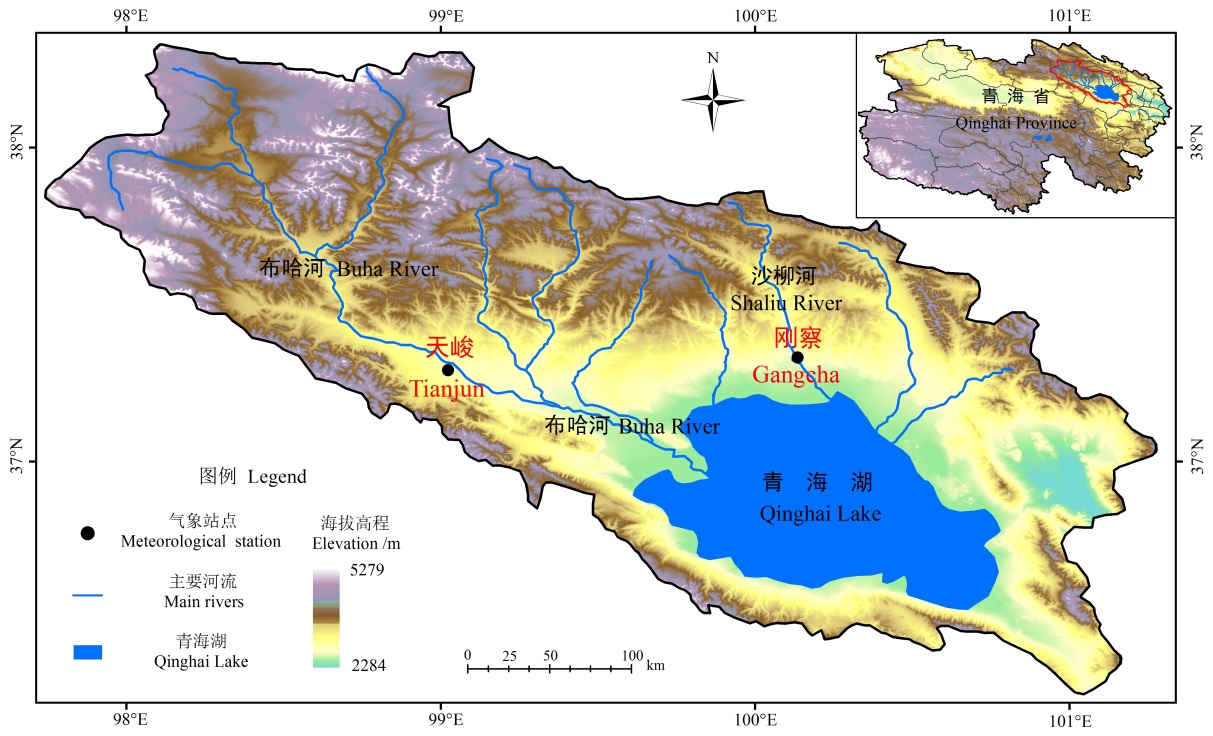
Fig. 1 Overview of Qinghai Lake
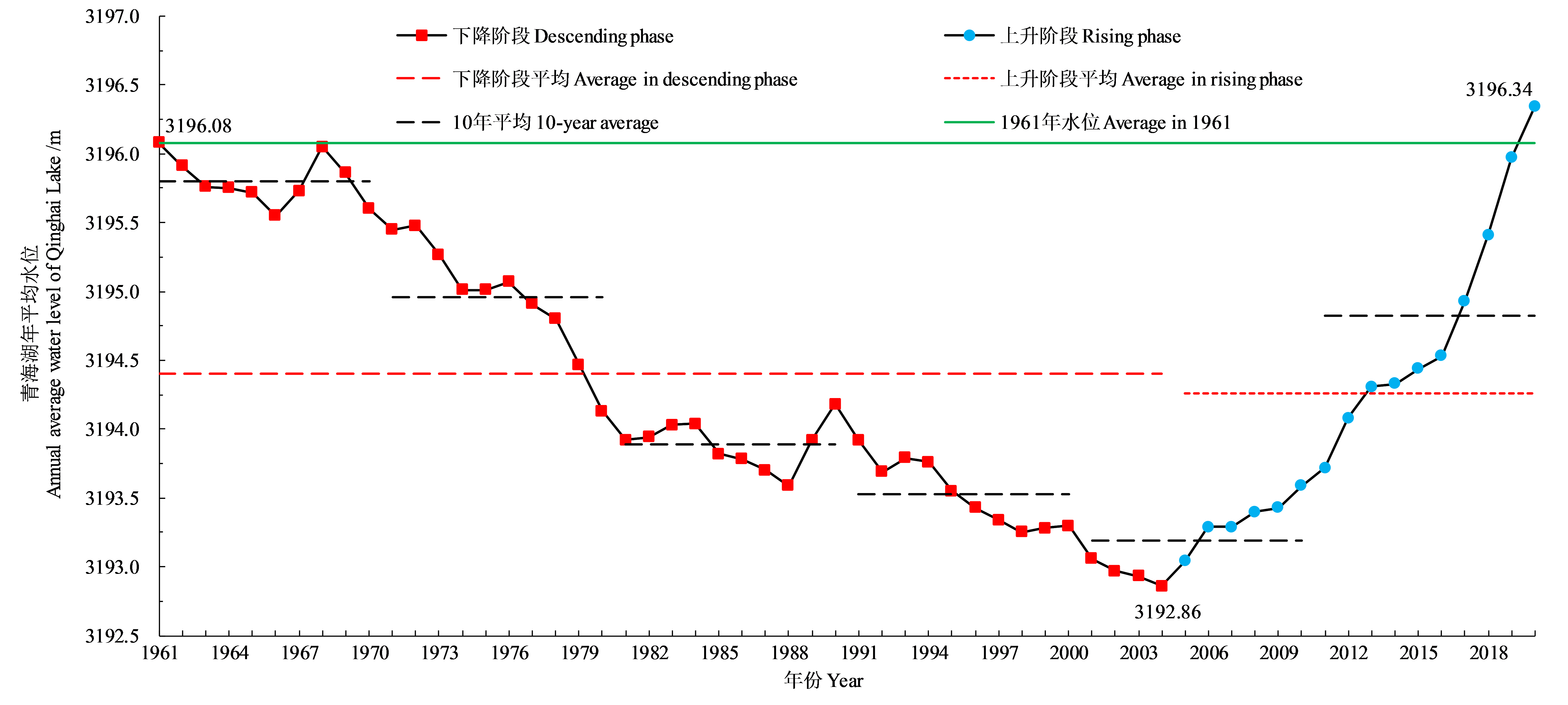
Fig. 2 Change trend of the annual average water level of Qinghai Lake in 1961-2020
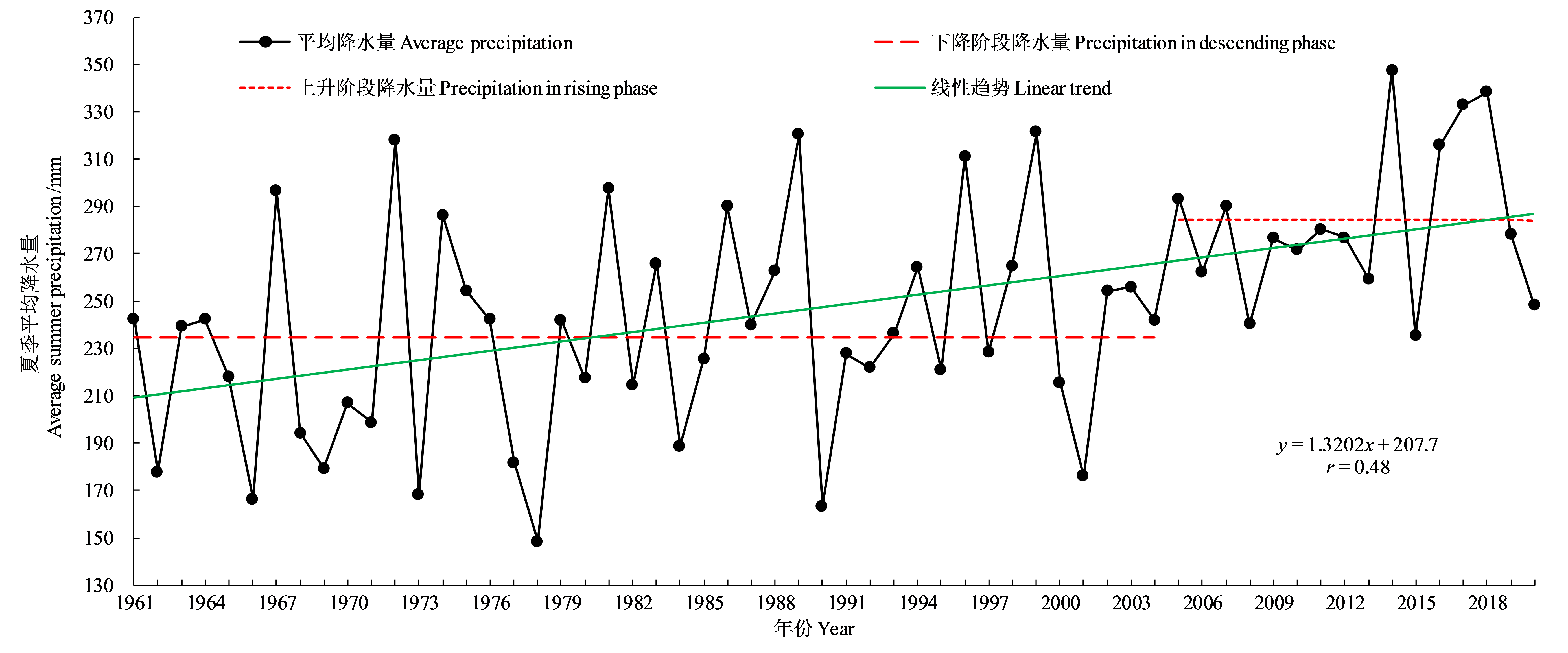
Fig. 3 Inter-annual variation trend of summer average rainfall in Qinghai Lake Basin
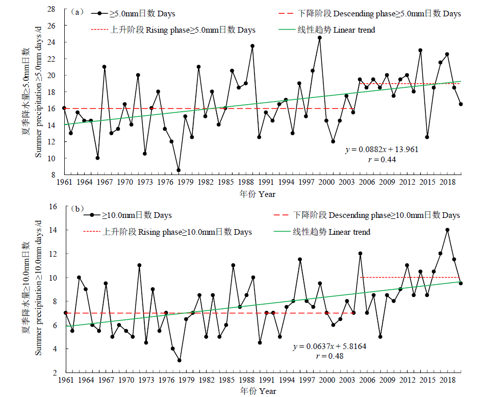
Fig. 4 Variation trend of the number of days of summer precipitation ≥5.0 mm and ≥10.0 mm in Qinghai Lake Basin
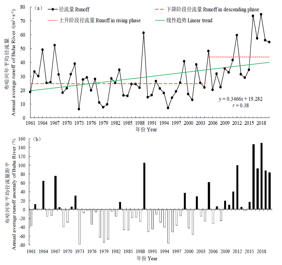
Fig. 5 Variation trend and anomaly of Buha River annual average runoff in Qinghai Lake Basin
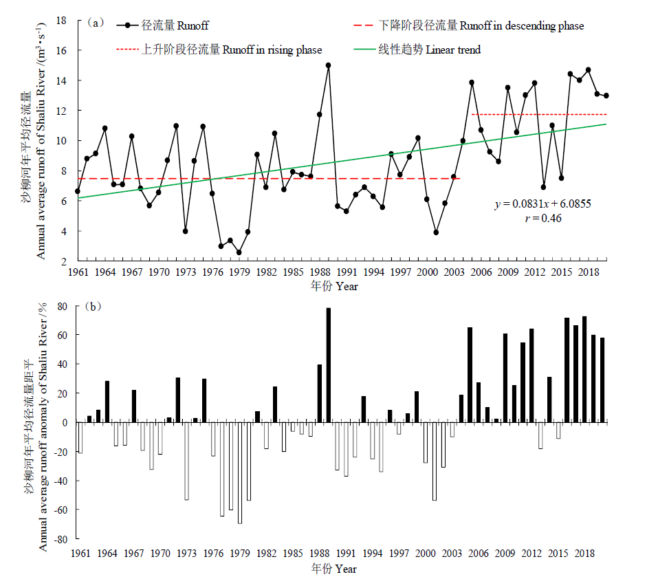
Fig. 6 Variation trend and anomaly of Shaliu River annual average runoff in Qinghai Lake Basin
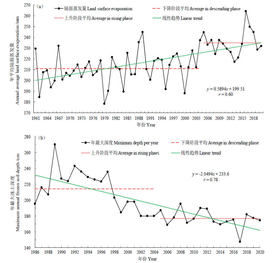
Fig. 7 Variation trend of land surface evaporation and annual maximum frozen soil depth in Qinghai Lake
| 时段 Time period | 年降水量距平百分率 Percentage of annual precipitation anomaly/% | 年蒸发量距平百分率 Percentage of annual evaporation anomaly/% |
|---|---|---|
| 2021-2030 | 0.9 | 5.9 |
| 2031-2040 | 6.3 | 6.3 |
| 2041-2050 | 10.6 | 7.4 |
| 2021-2050 | 5.9 | 6.5 |
Table 1 Anomaly percentages of annual precipitation and annual evaporation in different time periods in the future
| 时段 Time period | 年降水量距平百分率 Percentage of annual precipitation anomaly/% | 年蒸发量距平百分率 Percentage of annual evaporation anomaly/% |
|---|---|---|
| 2021-2030 | 0.9 | 5.9 |
| 2031-2040 | 6.3 | 6.3 |
| 2041-2050 | 10.6 | 7.4 |
| 2021-2050 | 5.9 | 6.5 |
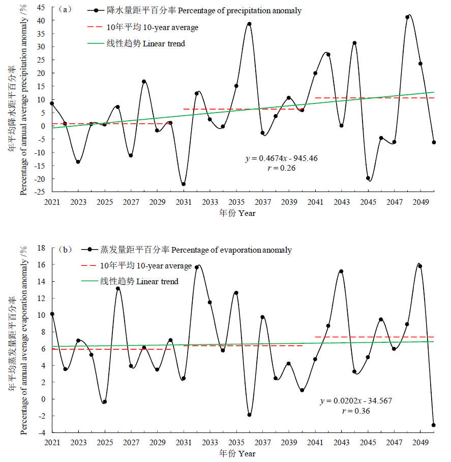
Fig. 8 Percentage of the future annual average precipitation and annual average evaporation anomaly in Qinghai Lake Basin
| 年份 Years | 变化水位 Changing water level/m | 年份 Years | 变化水位 Changing water level/m | 年份 Years | 变化水位 Changing water level/m |
|---|---|---|---|---|---|
| 2021 | 0.18 | 2031 | 0.07 | 2041 | 0.25 |
| 2022 | 0.17 | 2032 | 0.19 | 2042 | 0.27 |
| 2023 | 0.10 | 2033 | 0.16 | 2043 | 0.14 |
| 2024 | 0.16 | 2034 | 0.16 | 2044 | 0.30 |
| 2025 | 0.18 | 2035 | 0.21 | 2045 | 0.08 |
| 2026 | 0.17 | 2036 | 0.34 | 2046 | 0.13 |
| 2027 | 0.12 | 2037 | 0.14 | 2047 | 0.13 |
| 2028 | 0.23 | 2038 | 0.18 | 2048 | 0.33 |
| 2029 | 0.16 | 2039 | 0.21 | 2049 | 0.23 |
| 2030 | 0.16 | 2040 | 0.20 | 2050 | 0.16 |
| 合计 Total | 1.63 | 1.86 | 2.02 |
Table 2 Annual water level forecast changes of Qinghai Lake from 2021 to 2050
| 年份 Years | 变化水位 Changing water level/m | 年份 Years | 变化水位 Changing water level/m | 年份 Years | 变化水位 Changing water level/m |
|---|---|---|---|---|---|
| 2021 | 0.18 | 2031 | 0.07 | 2041 | 0.25 |
| 2022 | 0.17 | 2032 | 0.19 | 2042 | 0.27 |
| 2023 | 0.10 | 2033 | 0.16 | 2043 | 0.14 |
| 2024 | 0.16 | 2034 | 0.16 | 2044 | 0.30 |
| 2025 | 0.18 | 2035 | 0.21 | 2045 | 0.08 |
| 2026 | 0.17 | 2036 | 0.34 | 2046 | 0.13 |
| 2027 | 0.12 | 2037 | 0.14 | 2047 | 0.13 |
| 2028 | 0.23 | 2038 | 0.18 | 2048 | 0.33 |
| 2029 | 0.16 | 2039 | 0.21 | 2049 | 0.23 |
| 2030 | 0.16 | 2040 | 0.20 | 2050 | 0.16 |
| 合计 Total | 1.63 | 1.86 | 2.02 |
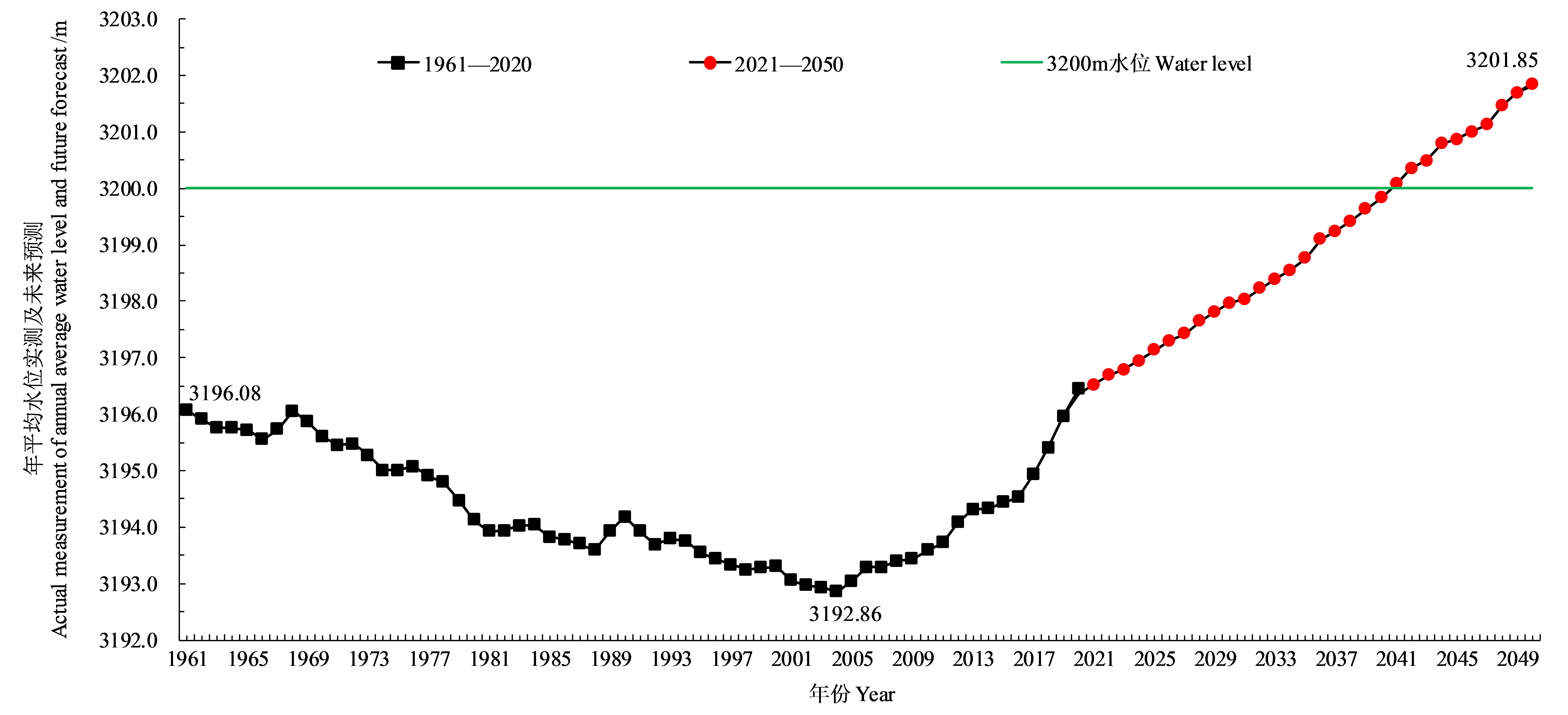
Fig. 9 Predicted change trend of the annual water level of Qinghai Lake from 2021 to 2050
| [1] |
CUI B L, LI X Y, 2016. The impact of climate changes on water level of Qinghai Lake in China over the past 50 years[J]. Hydrology Research, 47(2): 532-542.
DOI URL |
| [2] |
CUI B L, BEI X, LI X Y, et al., 2017. Exploring the geomorphological processes of Qinghai Lake and surrounding lakes in the northeastern Tibetan Plateau, using Multi temporal Landsat Imagery (1973-2015)[J]. Global and Planetary Change, 152: 152-175.
DOI URL |
| [3] | FAN C Y, SONG C Q, LI W K, et al., 2021. What drives the rapid water-level recovery of the largest lake (Qinghai Lake) of China over the past half century[J]. Journal of Hydrology, 593: 27-33. |
| [4] | IPCC, 2013. Climate change 2013: the physical science basis. Contribution of working group I to the fifth assessment report of the intergovernmental panel on climate change[R]. Cambridge: Cambridge University Press. |
| [5] |
JIANG S H, WANG M H, REN L L, et al., 2019. A framework for quantifying the impacts of climate change and human activities on hydrological drought in a semiarid basin of Northern China[J]. Hydrological Processes, 33(7): 1075-1088.
DOI URL |
| [6] |
YU W S, YAO T D, TIAN L D, et al., 2016. Short-term variability in the dates of the India monsoon onset and retreat on the southern and northern slopes of the central Himalayas as determined by precipitation stable isotopes[J]. Climate Dynamics, 47(1): 159-172.
DOI URL |
| [7] |
ZHAO L, WANG S Y S, JONATHAN M, 2017. Inter-decadal climate variations controlling the water level of Lake Qinghai over the Tibetan Plateau[J]. Journal of Hydrometeorology, 18(11): 3013-3025.
DOI URL |
| [8] | ZHU H, XIONG X, AO H Y, et al., 2020. Cladophora reblooming after half a century: effect of climate change-induced increases in the water level of the largest lake in Tibetan Plateau[J]. Environmental Science and Pollution Research, 27: 4175-4281. |
| [9] | 白爱娟, 黄融, 程志刚, 2014. 气候变暖情景下的青海湖水位变化[J]. 干旱区研究, 31(5): 792-797. |
| BAI A J, HUANG R, CHENG Z G, 2014. Change of water level of the Qinghai Lake under climate warming[J]. Arid Zone Research, 31(5): 792-797. | |
| [10] | 丛振涛, 倪广恒, 杨大文, 等, 2008. “蒸发悖论”在中国的规律分析[J]. 水科学进展, 19(2): 147-152. |
| CONG Z T, NI G H, YANG D W, et al., 2008. Evaporation paradox in China[J]. Advances in Water Science, 19(2): 147-152. | |
| [11] | 丁之勇, 鲁瑞洁, 刘畅, 等, 2018. 环青海湖地区气候变化特征及其季风环流因素[J]. 地球科学进展, 33(3): 281-292. |
| DING Z Y, LU R J, LIU C, et al., 2018. Temporal change characteristics of climatic and its relationships with atmospheric circulation patterns in Qinghai Lake Basin[J]. Advances in Earth Science, 33(3): 281-292. | |
| [12] | 杜嘉妮, 李其江, 刘希胜, 等, 2020. 青海湖1956—2017年水文变化特征分析[J]. 水生态学杂志, 41(4): 27-33. |
| DU J N, LI Q J, LIU X S, et al., 2020. Hydrological characteristics of Qinghai Lake, 1956-2017 [J]. Journal of Hydroecology, 41(4): 27-33. | |
| [13] | 韩有香, 刘彩红, 李国山, 2019. 青海高原典型生态区域未来气候变化趋势预估[J]. 草业科学, 36(6):1518-1530. |
| HAN Y X, LIU C H, LI G S, 2019. Forecast of future climate change trend in typical ecological regions of the Qinghai Plateau[J]. Pratacultural Science, 36(6): 1518-1530. | |
| [14] | 侯威, 2020. 青海湖流域生态环境地质条件与生态环境地质问题研究[D]. 北京: 中国地质大学. |
| HOU W, 2020. Research on eco-environmental geological conditions and eco-environmental geological problems in Qinghai Lake Basin[D]. Beijing: China University of Geosciences. | |
| [15] | 贾东于, 李开明, 杨丽薇, 等, 2020. CMIP5气候模式对未来30年太阳辐射变化的预估研究[J]. 太阳能学报, 41(3): 199-205. |
| JIA D Y, LI K M, YANG L W, et al., 2020. Prediction of solar radiation variation in future by CMIP5 climate model[J]. Acta Energiae Solaris Sinica, 41(3): 199-205. | |
| [16] | 李林, 申红艳, 刘彩红, 等, 2020. 青海湖水位波动对气候暖湿化情景的响应及其机理研究[J]. 气候变化研究进展, 16(5): 600-608. |
| LI L, SHEN H Y, LIU C H, et al., 2020. Response of water level fluctuation to climate warming and wetting scenarios and its mechanism on Qinghai Lake[J]. Climate Change Research, 16(5): 600-608. | |
| [17] | 李林, 时兴合, 申红艳, 等, 2011. 1960—2009年青海湖水位波动的气候成因探讨及其未来趋势预测[J]. 自然资源学报, 26(9): 1566-1574. |
| LI L, SHI X H, SHEN H Y, et al., 2011. Cause and water level fluctuation in Qinghai Lake from 1960 to 2009 and its future trend forecasting[J]. Journal of Natural Resources, 26(9): 1566-1574. | |
| [18] | 刘波, 马柱国, 冯锦明, 等, 2008. 1960年以来新疆地区蒸发皿蒸发与实际蒸发之间的关系[J]. 地理学报, 63(11): 1131-1139. |
| LIU B, MA Z G, FENG J M, et al., 2008. The relationship between pan evaporation and actual evapotranspiration in Xinjiang since 1960 [J]. Acta Geographica Sinica, 63(11): 1131-1139. | |
| [19] | 刘宝康, 2016. 气候变化背景下青海湖流域草地与湖泊时空变化特征研究[D]. 兰州: 兰州大学. |
| LIU B K, 2016. Research on temporal and spatial changes of grassland and lakes in Qinghai Lake Basin under the background of climate change[D]. Lanzhou: Lanzhou University. | |
| [20] | 刘义花, 马元仓, 杨延华, 等, 2020. 1961—2018年青海高原昼夜雨量时空变化特征分析[J]. 冰川冻土, 42(3): 996-1006. |
| LIU Y H, MA Y C, YANG Y H, et al., 2020. Research of the spatio-temporal variation characteristics of daytime and nighttime precipitation in the Qinghai Plateau from 1961 to 2018 [J]. Journal of Glaciology and Geocryology, 42(3): 996-1006. | |
| [21] | 潘蕊蕊, 李小雁, 胡广荣, 等, 2020. 青海湖流域季节性冻土区坡面土壤有机碳分布特征及其影响因素[J]. 生态学报, 40(18): 6374-6384. |
| PAN R R, LI X Y, HU G R, et al., 2020. Characteristics of soil carbon distribution and its controlling factors on hillslope in seasonal frozen area of Qinghai Lake Basin[J]. Acta Ecologica Sinica, 40(18): 6374-6384. | |
| [22] |
施雅风, 1990. 山地冰川与湖泊萎缩所指示的亚洲中部气候干暖化趋势与未来展望[J]. 地理学报, 45(1): 1-13.
DOI |
| SHI Y F, 1990. Glacier recession and lake shrinkage indicating the climatic warming and drying trend in central Asia[J]. Acta Geographica Sinica, 45(1): 1-13. | |
| [23] | 王政琪, 2017. CMIP5全球气候模式对东亚冬季气候特征模拟能力评估与未来变化预估[D]. 北京: 中国气象科学研究院. |
| WANG Z Q, 2017. Evaluation and projection of the CMIP5 models in simulating the change of the East Asian winter monsoon[D]. Beijing: Chinese Academy of Meteorological Sciences. | |
| [24] | 袁云, 李栋梁, 安迪, 2012. 青海湖水位变化对青藏高原气候变化的相应[J]. 高原气象, 31(1): 57-64. |
| YUAN Y, LI D L, AN D, 2012. Respons of water level in Qinghai Lake to climate change in the Qinghai-Xizang Plateau[J]. Plateau Meteorology, 31(1): 57-64. | |
| [25] | 姚檀栋, 朴世龙, 沈妙根, 等, 2017. 印度季风与西风相互作用在现代青藏高原产生连锁式环境效应[J]. 中国科学院院刊, 32(9): 976-984. |
| YAO T D, PIAO S L, SHEN M G, et al., 2017. Chained impacts on modern environment of interaction between Westerlies and Indian Monsoon on Tibetan Plateau[J]. Bulletin of Chinese Academy of Sciences, 32(9): 976-984. | |
| [26] | 朱延龙, 韩昆, 王芳, 2012. 青海湖流域气候变化特点及水文生态响应[J]. 中国水利水电科学研究院学报, 10(4): 260-266. |
| ZHU Y L, HAN K, WANG F, 2012. Climate change and responses of hydro-ecology in Qinghai Lake Watershed[J]. Journal of China Institute of Water Resources and Hydropower Research, 10(4): 260-266. | |
| [27] | 金章东, 张飞, 王红丽, 等, 2013. 2005年以来青海湖水位持续回升的原因分析[J]. 地球环境学报, 4(3): 1355-1362. |
| JIN Z D, ZHANG F, WANG H L, et al., 2013. The reasons of rising water level in Lake Qinghai since 2005 [J]. Journal of Earth Environment, 4(3): 1355-1362. | |
| [28] | 张洪源, 2018. 基于遥感的青藏高原湖泊水文要素变化分析及其对气候变化的响应研究[D]. 聊城: 聊城大学. |
| ZHANG H Y, 2018. Analysis of lake hydrological changes in Qinghai-Tibet Plateau based on remote sensing and its response to climate change[D]. Liaocheng: Liaocheng University. | |
| [29] | 周文翀, 韩振宇, 2018. CMIP5全球气候模式对中国黄河流域气候模拟能力的评估[J]. 气象与环境学报, 34(6): 42-55. |
| ZHOU W C, HAN Z Y, 2018. Assessing CMIP5 climate simulations and objective selection of models over the Yellow River basin[J]. Journal of Meteorology and Environment, 34(6): 42-55. |
| [1] | HAO Lei, ZHAI Yongguang, QI Wenchao, LAN Qiongqiong. Spatial-temporal Dynamics of Vegetation Carbon Sources/sinks in Inner Mongolia from 2001 to 2020 and Its Response to Climate Change [J]. Ecology and Environment, 2023, 32(5): 825-834. |
| [2] | CHEN Junfang, WU Xian, LIU Xiaolin, LIU Juan, YANG Jiarong, LIU Yu. Shaping Characteristics of Elemental Stoichiometry on Microbial Diversity under Different Soil Water Contents [J]. Ecology and Environment, 2023, 32(5): 898-909. |
| [3] | LI Hui, LI Bilong, GE Lili, HAN Chenhui, YANG Qian, ZHANG Yuejun. Temporal and Spatial Characteristics of Vegetation Evolution and Topographic Effects in Fenhe River Basin from 2000 to 2021 [J]. Ecology and Environment, 2023, 32(3): 439-449. |
| [4] | QI Yue, ZHANG Qiang, HU Shujuan, CAI Dihua, ZHAO Funian, ZHANG Kai, WANG Heling, WANG Runyuan. Climate Change and Its Impact on Winter Wheat Potential Productivity of Loess Plateau in China [J]. Ecology and Environment, 2022, 31(8): 1521-1529. |
| [5] | DENG Tianle, XIE Liyong, ZHANG Fengzhe, ZHAO Hongliang, JIANG Yutong. Competition for Growth Space between Barnyard Grass and Rice under Elevated Atmospheric CO2 Concentration [J]. Ecology and Environment, 2022, 31(8): 1566-1572. |
| [6] | LU Yanyu, SUN Wei, FANG Yanqiu, TANG Weian, DENG Hanqing, HE Dongyan. Estimating the Climatic Potential Productivity and the Climatic Capacity of Food Security Based on the Cropping Structure in Anhui Province [J]. Ecology and Environment, 2022, 31(7): 1293-1305. |
| [7] | LI Dengke, WANG Zhao. Quantitative Analysis of the Impact of Climate Change and Human Activities on Vegetation NPP in Shaanxi Province [J]. Ecology and Environment, 2022, 31(6): 1071-1079. |
| [8] | CAO Xiaoyun, ZHU Cunxiong, CHEN Guoqian, SUN Shujiao, ZHAO Huifang, ZHU Wenbin, ZHOU Bingrong. Surface Greenness Change and Topographic Differentiation over Qaidam Basin from 2000 to 2021 [J]. Ecology and Environment, 2022, 31(6): 1080-1090. |
| [9] | ZHU Jinfu, HUANG Ruiling, DONG Zhiqiang, MAO Xiaoning, ZHOU Huakun. Response of the Soil Bacterial Community to Nitrogen Addition in Alpine Wetland of Qinghai Lake [J]. Ecology and Environment, 2022, 31(6): 1101-1109. |
| [10] | SHI Zhiyu, WANG Yating, ZHAO Qing, ZHANG Lianpeng, ZHU Changming. The Spatiotemporal Changes of NPP and Its Driving Mechanisms in China from 2001 to 2020 [J]. Ecology and Environment, 2022, 31(11): 2111-2123. |
| [11] | LIU Bingru. Response of Thermal Adaptability of Soil Microbial Respiration and Microbial Community and Diversity to Global Climate Change: A Review [J]. Ecology and Environment, 2022, 31(1): 181-186. |
| [12] | ZHANG Jing, DU Jiaqiang, SHENG Zhilu, ZHANG Yangchengsi, WU Jinhua, LIU Bo. Spatio-temporal Changes of Vegetation Cover and Their Influencing Factors in the Yellow River Basin from 1982 to 2015 [J]. Ecology and Environment, 2021, 30(5): 929-937. |
| [13] | HUANG Dong, LI Peng, DONG Nan. Spatial-temporal Differentiation of GS_NDVI in Recent 20 Years and Its Responses to Climate Change and LUCC in the Bohai Coastal Region [J]. Ecology and Environment, 2021, 30(12): 2275-2284. |
| Viewed | ||||||
|
Full text |
|
|||||
|
Abstract |
|
|||||
Copyright © 2021 Editorial Office of ACTA PETROLEI SINICA
Address:No. 6 Liupukang Street, Xicheng District, Beijing, P.R.China, 510650
Tel: 86-010-62067128, 86-010-62067137, 86-010-62067139
Fax: 86-10-62067130
Email: syxb@cnpc.com.cn
Support byBeijing Magtech Co.ltd, E-mail:support@magtech.com.cn