Ecology and Environmental Sciences ›› 2026, Vol. 35 ›› Issue (6): 898-908.DOI: 10.16258/j.cnki.1674-5906.2026.06.007
• Research Article [Ecology] • Previous Articles Next Articles
LUO Manqiu1,2,3( ), TONG Xiaowei1,2,*(), YUE Yuemin1,2, CHANG Jingyi1,2,3, QI Xiangkun1,2, WANG Kelin1,2
Received:2025-10-11
Revised:2026-01-21
Accepted:2026-03-07
Online:2026-06-18
Published:2026-06-08
罗曼秋1,2,3(), 童晓伟1,2,*(), 岳跃民1,2, 常静怡1,2,3, 祁向坤1,2, 王克林1,2
通讯作者:
* 童晓伟,E-mail: 作者简介:罗曼秋(2001年生),女,硕士研究生,主要从事生态遥感方面的研究。E-mail: luomanqiu23@mails.ucas.ac.cn
基金资助:CLC Number:
LUO Manqiu, TONG Xiaowei, YUE Yuemin, CHANG Jingyi, QI Xiangkun, WANG Kelin. Spatio-temporal Forest Cover Dynamics and Driving Processes in Southwest China (1986‒2018)[J]. Ecology and Environmental Sciences, 2026, 35(6): 898-908.
罗曼秋, 童晓伟, 岳跃民, 常静怡, 祁向坤, 王克林. 西南三省1986-2018年森林覆盖时空动态及驱动过程分析[J]. 生态环境学报, 2026, 35(6): 898-908.
Add to citation manager EndNote|Ris|BibTeX
URL: https://www.jeesci.com/EN/10.16258/j.cnki.1674-5906.2026.06.007
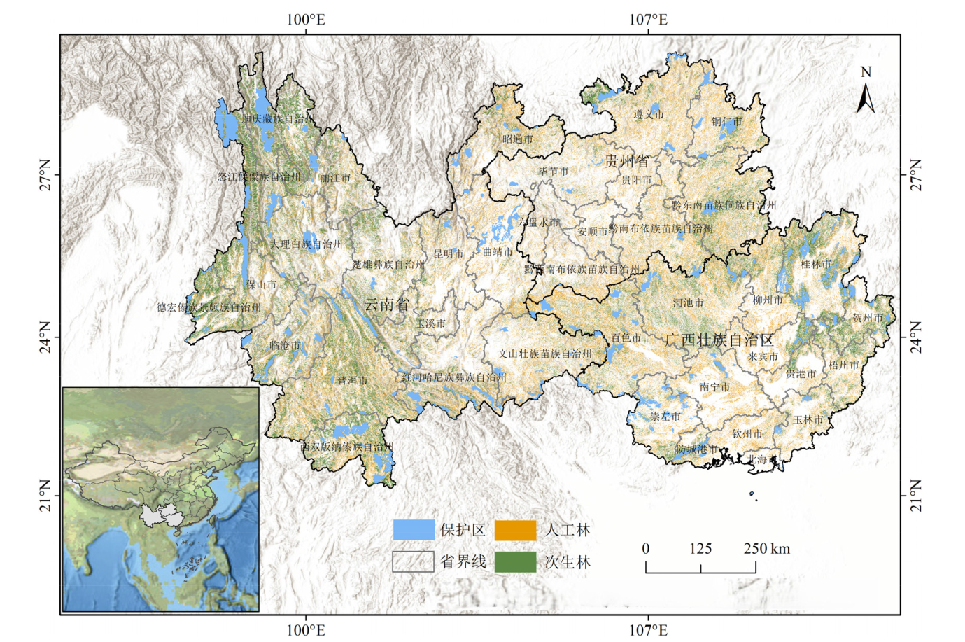
Figure 1 Location of the study area and distribution of plantation and secondary forests in the study area
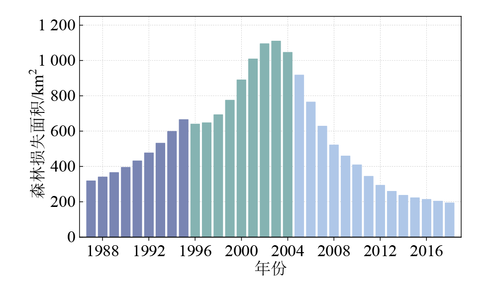
Figure 2 Forest lost changes in the study area from 1986 to 2018
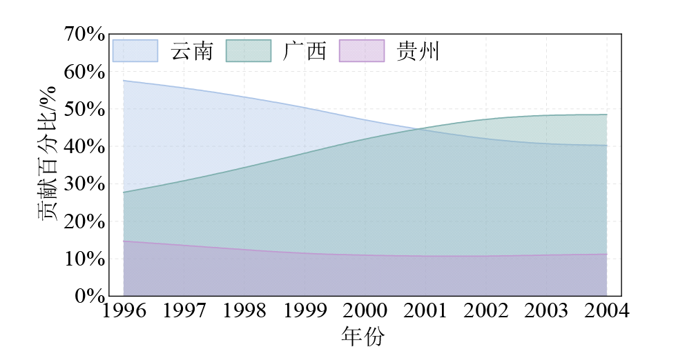
Figure 3 Contribution of forest loss from different provinces to the total forest loss in the study area in 1996?2004
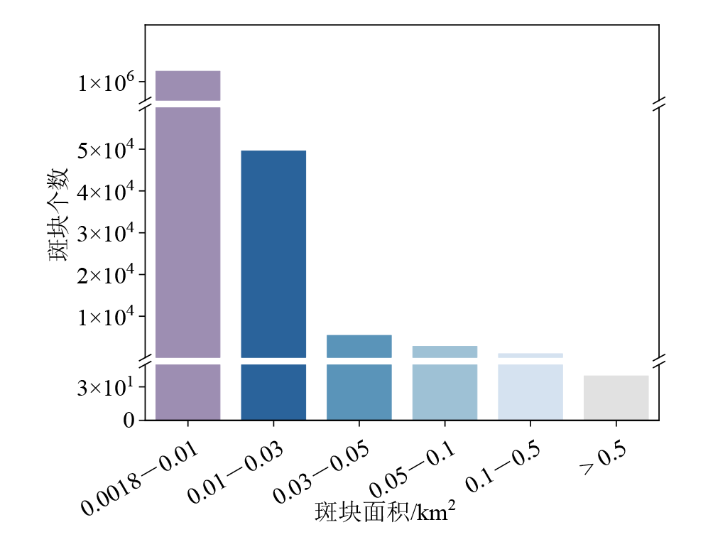
Figure 4 Histogram of forest loss patch size in the study area
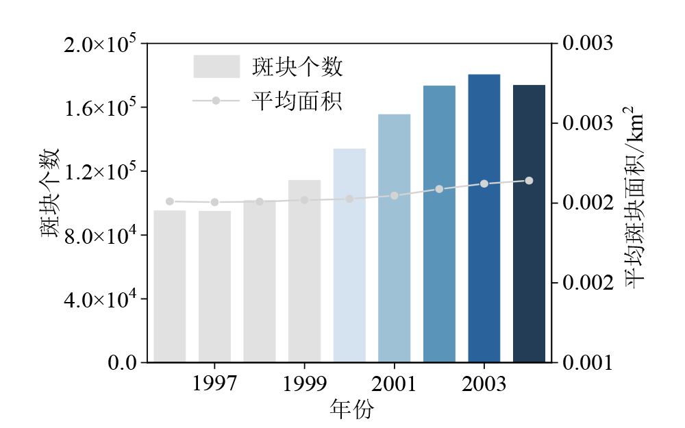
Figure 5 Changes in the number and average size of forest loss patches in the study area in 1996?2004
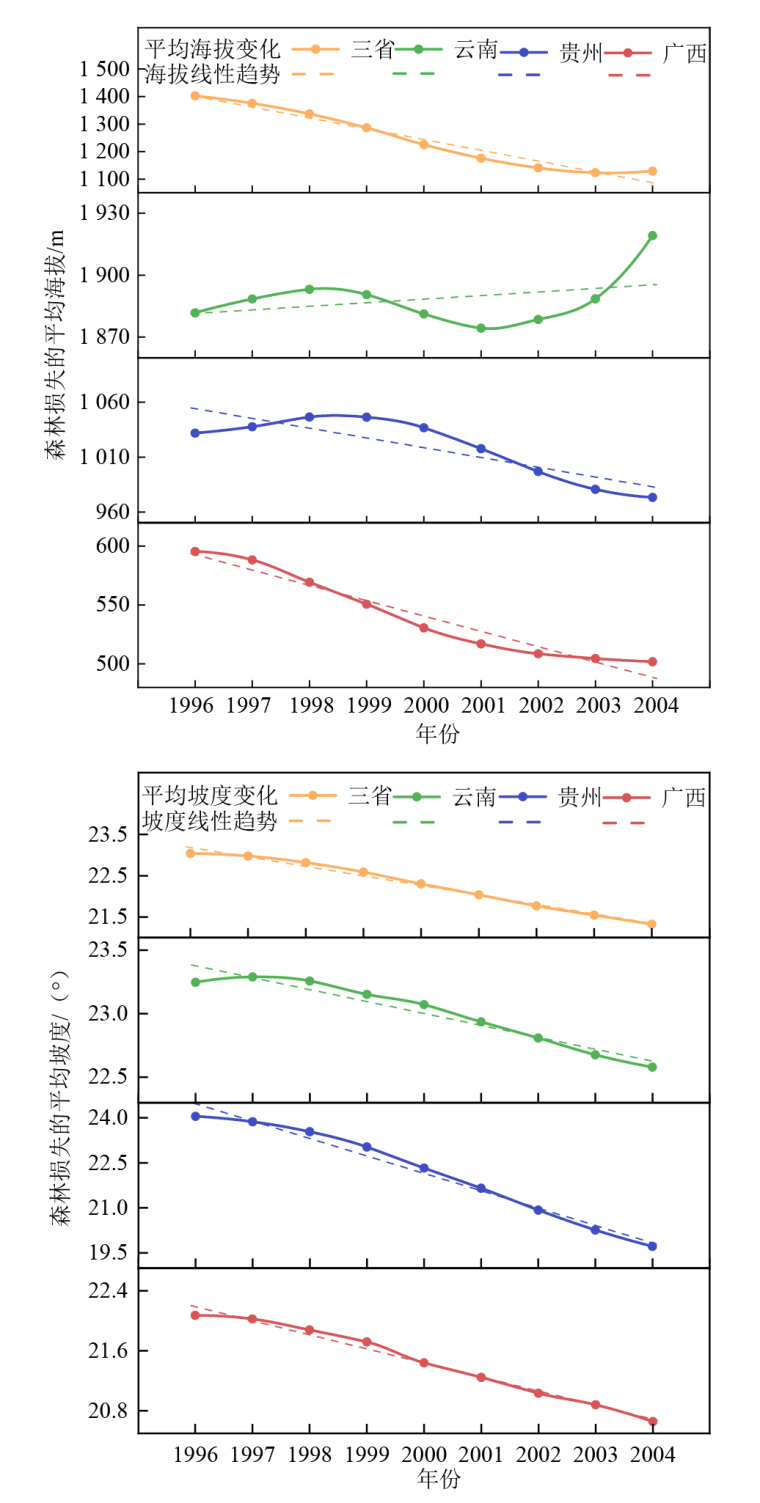
Figure 6 Mean elevation and slope changes of forest loss in different areas in 1996?2004
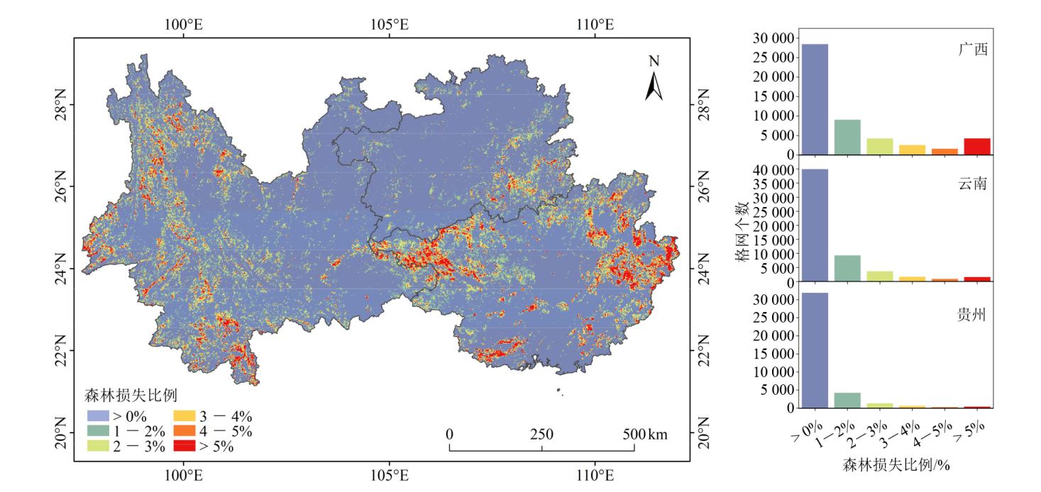
Figure 7 Spatial distribution of forest loss percentage (1996?2004)
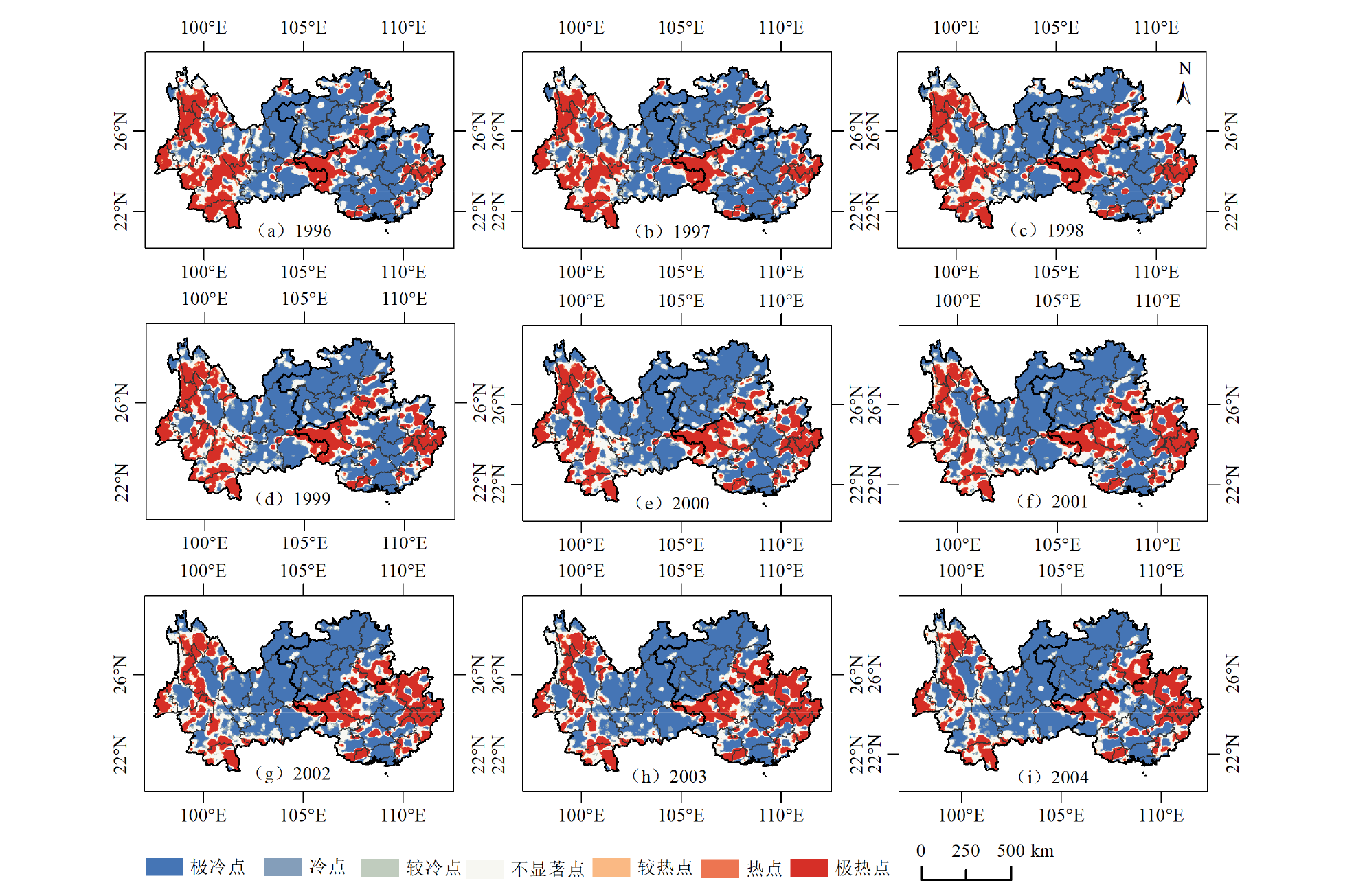
Figure 8 Distribution of forest loss hotspots and coldspots in 1996?2004
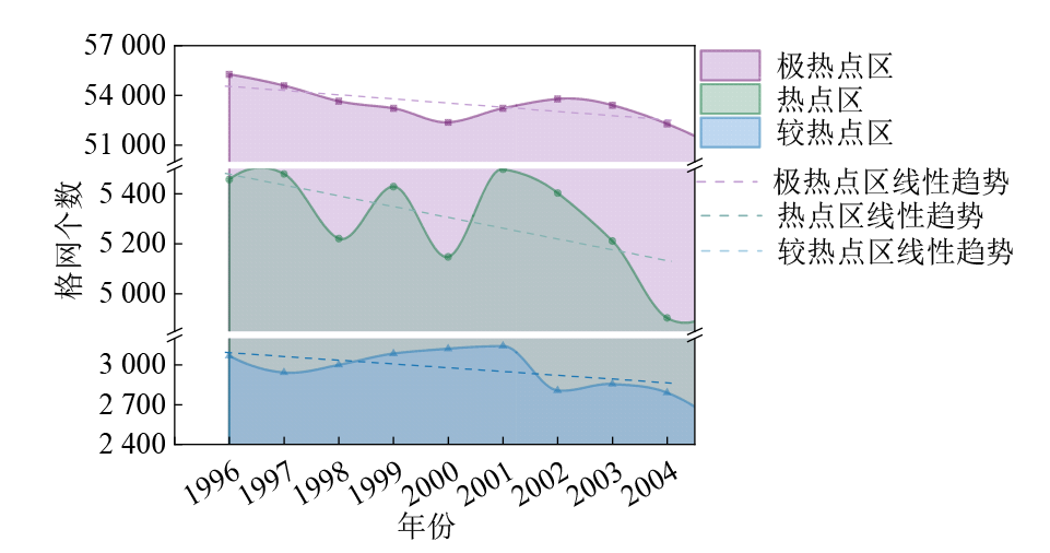
Figure 9 Temporal changes (1996-2004) in the number of grid cells by hotspot types
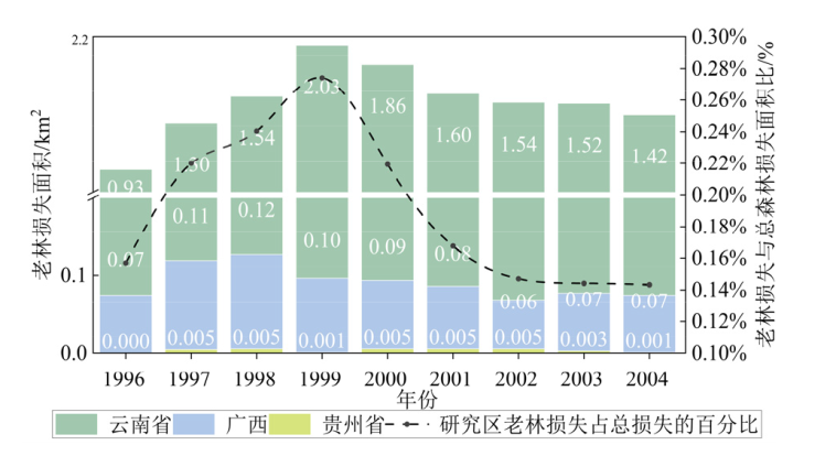
Figure 10 Changes of old-growth forest loss in different provinces in 1996?2004

Figure 11 Old-growth forest loss in protected areas
| 年份 | 土地利用类型/km2 | ||||||
|---|---|---|---|---|---|---|---|
| 森林 | 矮小植被 | 建筑用地 | 水体 | 耕地 | 裸地 | 合计 | |
| 1996 | 113.81 | 17.43 | 12.32 | 1.65 | 1.82 | 0.01 | 147.05 |
| 1997 | 126.10 | 18.42 | 13.04 | 2.34 | 2.04 | 0.02 | 161.95 |
| 1998 | 151.36 | 21.03 | 15.16 | 3.17 | 2.53 | 0.02 | 193.27 |
| 1999 | 191.41 | 24.38 | 18.54 | 4.63 | 3.04 | 0.03 | 242.02 |
| 2000 | 248.09 | 28.52 | 23.21 | 6.23 | 3.86 | 0.04 | 309.96 |
| 2001 | 314.88 | 34.36 | 28.20 | 7.78 | 4.46 | 0.04 | 389.73 |
| 2002 | 382.07 | 39.29 | 32.96 | 8.74 | 4.93 | 0.06 | 468.05 |
| 2003 | 433.14 | 42.03 | 35.17 | 9.12 | 5.14 | 0.05 | 524.65 |
| 2004 | 457.96 | 42.38 | 35.27 | 7.87 | 4.87 | 0.06 | 548.41 |
| 合计 | 2418.82 | 267.84 | 213.87 | 51.53 | 32.70 | 0.32 | 2985.09 |
Table 1 Land use types after forest loss (1996?2004)
| 年份 | 土地利用类型/km2 | ||||||
|---|---|---|---|---|---|---|---|
| 森林 | 矮小植被 | 建筑用地 | 水体 | 耕地 | 裸地 | 合计 | |
| 1996 | 113.81 | 17.43 | 12.32 | 1.65 | 1.82 | 0.01 | 147.05 |
| 1997 | 126.10 | 18.42 | 13.04 | 2.34 | 2.04 | 0.02 | 161.95 |
| 1998 | 151.36 | 21.03 | 15.16 | 3.17 | 2.53 | 0.02 | 193.27 |
| 1999 | 191.41 | 24.38 | 18.54 | 4.63 | 3.04 | 0.03 | 242.02 |
| 2000 | 248.09 | 28.52 | 23.21 | 6.23 | 3.86 | 0.04 | 309.96 |
| 2001 | 314.88 | 34.36 | 28.20 | 7.78 | 4.46 | 0.04 | 389.73 |
| 2002 | 382.07 | 39.29 | 32.96 | 8.74 | 4.93 | 0.06 | 468.05 |
| 2003 | 433.14 | 42.03 | 35.17 | 9.12 | 5.14 | 0.05 | 524.65 |
| 2004 | 457.96 | 42.38 | 35.27 | 7.87 | 4.87 | 0.06 | 548.41 |
| 合计 | 2418.82 | 267.84 | 213.87 | 51.53 | 32.70 | 0.32 | 2985.09 |

Figure 12 Land use types of non-regenerated forest loss areas by province
| [1] |
ALKAMA R, CESCATTI A, 2016. Biophysical climate impacts of recent changes in global forest cover[J]. Science, 351(6273): 600-604.
DOI PMID |
| [2] |
AUSTIN K G, SCHWANTES A, GU Y, et al., 2019. What causes deforestation in Indonesia?[J]. Environmental Research Letters, 14: 024007.
DOI URL |
| [3] |
BASTIN J F, FINEGOLD Y, GARCIA C, et al., 2019. The global tree restoration potential[J]. Science, 365(6448): 76-79.
DOI URL |
| [4] |
BO X, CHEN R S, AN L, et al., 2021. Telecoupling urbanization and mountain areas deforestation between 2000 and 2020: Evidence from Zhejiang Province, China[J]. Land Degradation & Development, 32(16): 4727-4739.
DOI URL |
| [5] |
BRANDT M, YUE Y M, WIGNERON J P, et al., 2018. Satellite-observed Major Greening and Biomass Increase in South China Karst During Recent Decade[J]. Earth’s Future, 6(7): 1017-1028.
DOI URL |
| [6] |
CADAVID-FLOREZ L, LABORDE J, MCLEAN D J, 2020. Isolated trees and small woody patches greatly contribute to connectivity in highly fragmented tropical landscapes[J]. Landscape and Urban Planning, 196: 103745.
DOI URL |
| [7] |
CHENG K, CHEN Y, XIANG T, et al., 2024. A 2020 forest age map for China with 30 m resolution[J]. Earth System Science Data, 16: 803-819.
DOI URL |
| [8] |
COHEN W B, YANG Z Q, HEALEY S P, et al., 2018. A LandTrendr multispectral ensemble for forest disturbance detection[J]. Remote Sensing of Environment, 205: 131-140.
DOI URL |
| [9] |
CURTIS P G, SLAY C M, HARRIS N L, et al., 2018. Classifying drivers of global forest loss[J]. Science, 361(6407): 1108-1111.
DOI PMID |
| [10] |
DING Z, LIU Y, WANG L C, et al., 2021. Effects and implications of ecological restoration projects on ecosystem water use efficiency in the karst region of Southwest China[J]. Ecological Engineering, 170: 106356.
DOI URL |
| [11] |
FENG Y, ZIEGLER A D, ELSEN P R, et al., 2021. Upward expansion and acceleration of forest clearance in the mountains of Southeast Asia[J]. Nature Sustainability, 4(10): 892-899.
DOI |
| [12] |
GELDMANN J, BARNES M, COAD L, et al., 2013. Effectiveness of terrestrial protected areas in reducing habitat loss and population declines[J]. Biological Conservation, 161: 230-238.
DOI URL |
| [13] |
GILHEN-BAKER M, ROVIELLO V, BERESFORD-KROEGER D, et al., 2022. Old growth forests and large old trees as critical organisms connecting ecosystems and human health: A review[J]. Environmental Chemistry Letters, 20: 1529-1538.
DOI |
| [14] |
GODAR J, GARDNER T A, TIZADO E J, et al., 2014. Actor-specific contributions to the deforestation slowdown in the Brazilian Amazon[J]. Proceedings of the National Academy of Sciences, 111(43): 15591-15596.
DOI URL |
| [15] |
HANSEN M C, POTAPOV P V, MOORE R, et al., 2013. High-Resolution Global Maps of 21st-Century Forest Cover Change[J]. Science, 342(6160): 850-853.
DOI PMID |
| [16] |
HANSEN M, POTAPOV P, PICKENS A, et al., 2022. Global land use extent and dispersion within natural land cover using Landsat data[J]. Environmental Research Letters, 17: 034050.
DOI |
| [17] |
HE X Y, SPRACKLEN D V, HOLDEN J, et al., 2025. Tropical montane forest loss dominated by increased 1-10 hectare-sized patches[J]. Environmental Research Letters, 20: 024039.
DOI |
| [18] |
JANA M, SAR N, 2016. Modeling of hotspot detection using cluster outlier analysis and Getis-Ord Gi* statistic of educational development in upper-primary level, India[J]. Modeling Earth Systems and Environment, 2: 60.
DOI URL |
| [19] | JHA C S, GOPARAJU L, TRIPATHI A, et al., 2005. Forest fragmentation and its impact on species diversity: An analysis using remote sensing and GIS[J]. Biodiversity & Conservation, 14: 1681-1698. |
| [20] |
JIANG Z C, LIAN Y Q, QIN X Q, 2014. Rocky desertification in Southwest China: Impacts, causes, and restoration[J]. Earth-Science Reviews, 132: 1-12.
DOI URL |
| [21] |
KENNEDY R E, YANG Z, COHEN W B, 2010. Detecting trends in forest disturbance and recovery using yearly Landsat time series: 1. LandTrendr — Temporal segmentation algorithms[J]. Remote Sensing of Environment, 114(12): 2897-2910.
DOI URL |
| [22] |
LAURANCE W F, CAROLINA USECHE D, RENDEIRO J, et al., 2012. Averting biodiversity collapse in tropical forest protected areas[J]. Nature, 489: 290-294.
DOI |
| [23] |
MAO C, TONG X W, BRANDT M, et al., 2025. How three decades of forestation has impacted forest fragmentation in southern China[J]. Remote Sensing, 17(11): 1922.
DOI URL |
| [24] |
MENG G, WU S R, YU Y T, 2025. Forestry policy effectiveness and performance evaluation in China - Quantitative study based on policy texts 1998-2020[J]. Forest Policy and Economics, 170: 103367.
DOI URL |
| [25] | Food and Agriculture Organization of the United Nations, 2020. Global Forest Resources Assessment 2020 - Key findings[R]. Rome: FAO: 1-3. |
| [26] |
NEPSTAD D, SOARES-FILHO B S, MERRY F, et al., 2009. The End of Deforestation in the Brazilian Amazon[J]. Science, 326(5958): 1350-1351.
DOI URL |
| [27] |
PRASETYO L B, DHARMAWAN A H, NASDIAN F T, et al., 2016. Historical forest fire occurrence analysis in Jambi province during the period of 2000-2015: Its distribution & land cover trajectories[J]. Procedia Environmental Sciences, 33: 450-459.
DOI URL |
| [28] |
PRĂVĂLIE R, 2018. Major perturbations in the Earth’s forest ecosystems. Possible implications for global warming[J]. Earth-Science Reviews, 185: 544-571.
DOI URL |
| [29] |
QIN Y W, XIAO X M, WIGNERON J P, et al., 2021. Carbon loss from forest degradation exceeds that from deforestation in the Brazilian Amazon[J]. Nature Climate Change, 11: 442-448.
DOI |
| [30] |
SHIMADA M, ITOH T, MOTOOKA T, et al., 2014. New global forest/non-forest maps from ALOS PALSAR data (2007-2010)[J]. Remote Sensing of Environment, 155: 13-31.
DOI URL |
| [31] |
SONG X P, HANSEN M C, STEHMAN S V, et al., 2018. Global land change from 1982 to 2016[J]. Nature, 560: 639-643.
DOI |
| [32] |
TONG X W, BRANDT M, YUE Y M, et al., 2018. Increased vegetation growth and carbon stock in China karst via ecological engineering[J]. Nature Sustainability, 1: 44-50.
DOI |
| [33] | TONG X W, BRANDT M, YUE Y M, et al., 2023. Reforestation policies around 2000 in southern China led to forest densification and expansion in the 2010s[J]. Communications Earth & Environment, 4: 260. |
| [34] |
WADE C M, AUSTIN K G, CAJKA J, et al., 2020. What Is Threatening Forests in Protected Areas? A Global Assessment of Deforestation in Protected Areas, 2001-2018[J]. Forests, 11(5): 539.
DOI PMID |
| [35] |
WANG K L, ZHANG C H, CHEN H S, et al., 2019. Karst landscapes of China: Patterns, ecosystem processes and services[J]. Landscape Ecology, 34: 2743-2763.
DOI |
| [36] |
WEI X X, LIU R G, LIU Y, 2023. Forest Change in China: A Review[J]. Chinese Geographical Science, 33(3): 489-502.
DOI |
| [37] |
ZHANG J Q, CORLETT R T, ZHAI D, 2019. After the rubber boom: good news and bad news for biodiversity in Xishuangbanna, Yunnan, China[J]. Regional Environmental Change, 19: 1713-1724.
DOI |
| [38] |
ZHANG K, DE ALMEIDA CASTANHO A D, GALBRAITH D R, et al., 2015. The fate of Amazonian ecosystems over the coming century arising from changes in climate, atmospheric CO2, and land use[J]. Global Change Biology, 21(7): 2569-2587.
DOI URL |
| [39] | 包蕊, 李涛, 张欣怡, 等, 2021. 森林生态系统损害评估体系与管理制度研究[J]. 生态学报, 41(3): 924-933. |
| BAO R, LI T, ZHANG X Y, et al., 2021. Study on the assessment and management system of forest ecosystem damage[J]. Acta Ecologica Sinica, 41(3): 924-933. | |
| [40] |
陈文洁, 陈阳, 夏江周, 2024. 林龄数据及其估算方法研究进展[J]. 遥感技术与应用, 39(5): 1039-1053.
DOI |
| CHEN W J, CHEN Y, XIA J Z, 2024. Review of forest age datasets and their estimation methods[J]. Remote Sensing Technology and Application, 39(5): 1039-1053. | |
| [41] | 李春干, 李振, 2021. 机载激光雷达大区域亚热带森林参数估测的普适性模型式[J]. 林业科学, 57(10): 23-35. |
| LI C G, LI Z, 2021. Generalizing predictive models of sub-tropical forest inventory attributes using an area-based approach with airborne LiDAR data[J]. Scientia Silvae Sinicae, 57(10): 23-35. | |
| [42] | 吕莹莹, 钱者东, 王晔, 等, 2024. 中国市域自然保护区时空格局演变特征[J]. 生态学报, 44(10): 4021-4037. |
| LÜ Y Y, QIAN Z D, WANG Y, et al., 2024. City-scale spatiotemporal evolution characteristics of nature reserves in China[J]. Acta Ecologica Sinica, 44(10): 4021-4037. | |
| [43] | 农胜奇, 张伟, 蔡会德, 2014. 1977-2010年广西森林资源变化动态及其主要驱动因素分析[J]. 广西林业科学, 43(2): 171-178. |
| NONG S Q, ZHANG W, CAI H D, et al., 2014. The dynamic change and main driving factors of forest resources in Guangxi from 1977 to 2010[J]. Guangxi Forestry Science, 43(2): 171-178. | |
| [44] | 庞勇, 蒙诗栎, 史锴源, 等, 2021. 中国天然林保护工程区森林覆盖遥感监测[J]. 生态学报, 41(13): 5080-5092. |
| PANG Y, MENG S L, SHI K Y, et al., 2021. Forest coverage monitoring in the Natural Forest Protection Project area of China[J]. Acta Ecologica Sinica, 41(13): 5080-5092. | |
| [45] |
王昊, 吕植, 顾垒, 等, 2015. 基于Global Forest Watch观察2000-2013年间中国森林变化[J]. 生物多样性, 23(5): 575-582.
DOI |
|
WANG H, LÜ Z, GU L, et al., 2015. Observations of China’s forest change (2000-2013) based on Global Forest Watch dataset[J]. Biodiversity Science, 23(5): 575-582.
DOI URL |
|
| [46] | 王淑静, 2022. 近20年西南地区森林变化特征遥感监测及时空分析[D]. 重庆: 西南大学: 19-32. |
| WANG S J, 2022. Remote sensing monitoring and temporal and spatial analysis of forest change characteristics in Southwest China in recent 20 years[D]. Chongqing: Southwest University: 19-32. | |
| [47] | 王旭熙, 彭立, 苏春江, 等, 2016. 基于景观生态安全格局的低丘缓坡土地资源开发利用——以四川省泸县为例[J]. 生态学报, 36(12): 3646-3654. |
| WANG X X, PENG L, SU C J, et al., 2016. Development and utilization of low-slope hilly land resources based on a landscape security pattern theory: A case study in Luxian County, Sichuan Province[J]. Acta Ecologica Sinica, 36(12): 3646-3654. | |
| [48] | 余涛, 庞勇, 蒙诗栎, 等, 2023. 天然林资源保护工程区植被覆盖度遥感估算及变化分析[J]. 北京林业大学学报, 45(5): 1-13. |
| YU T, PANG Y, MENG S L, et al., 2023. Remote sensing estimation and change analysis of fractional vegetation coverage in Natural Forest Resource Protection Project area[J]. Journal of Beijing Forestry University, 45(5): 1-13. | |
| [49] |
周彬, 蒋有绪, 臧润国, 2010. 西南地区天然林资源近60年动态分析[J]. 自然资源学报, 25(9): 1536-1546.
DOI |
|
ZHOU B, JIANG T X, ZANG R G, et al., 2010. Resource dynamics of natural forests in southwest China in recent 60 years[J]. Journal of Natural Resources, 25(9): 1536-1546.
DOI |
|
| [50] | 周维, 刘国华, 段兴武, 等, 2022. 滇金丝猴分布区森林面积变化的时空特征及其影响因素[J]. 生态学报, 42(2): 791-803. |
| ZHOU W, LIU G H, DUAN X W, et al., 2022. Spatio-temporal characteristics of forest area change and its determinants in the distribution area of Yunnan snub-nosed monkey (Rhinopithecus bieti)[J]. Acta Ecologica Sinica, 42(2): 791-803. | |
| [51] |
朱若柠, 沈文娟, 张亚丽, 等, 2019. 基于时间序列MODIS-VCF数据的云南省森林覆盖变化及破碎化分析[J]. 南京林业大学学报(自然科学版), 43(2): 184-190.
DOI |
| ZHU R N, SHEN W J, ZHANG Y L, et al., 2019. Assessing changes in forest coverage and forest fragmentation patterns in Yunnan Province from time series MODIS-VCF products (2000-2016)[J]. Journal of Nanjing Forestry University (Natural Sciences Edition), 43(2): 184-190. |
| [1] | FENG Xuedi, DENG Yingbin, LI Zhao, JIA Yiwen, LI Tong, HUANG Jiacheng, CHEN Renrong, ZHANG Fei, LI Xin, XU Yang, WU Shangrong. Analysis of Temporal and Spatial Variation of Reservoir Chlorophyll-a Based on Multi-Scale Remote Sensing Data [J]. Ecology and Environmental Sciences, 2026, 35(6): 963-975. |
| [2] | ZHAO Shuang, NIE Qianyu, YUE Ang, WANG Dongchuan, SUN Xiaowei, ZHANG Haotian, LIU Haotian, YE Kai. Spatial Distribution Characteristics and Driving Mechanisms of Cultivated Land Fragmentation in Typical Agricultural Regions of Northern China under Topographic-Economic Synergy [J]. Ecology and Environmental Sciences, 2026, 35(4): 642-653. |
| [3] | WU Xiyan, LI Weijun, KA Nate, PENG Yujie. Analysis of China’s Continuous Temporal xCO2 Change in 2023 Based on Random Forest and OCO-2 Remote Sensing Data [J]. Ecology and Environmental Sciences, 2025, 34(9): 1341-1350. |
| [4] | ZHAO Wenqi, ZHANG Jiahua, ZHANG Peng, BAI Linyan, YAO Fengmei. Progress of Vegetation Phenology Monitoring Technology and Remote Sensing Inversion Method [J]. Ecology and Environmental Sciences, 2025, 34(9): 1473-1482. |
| [5] | ZHANG Yali, HUANG Zhujun, TIAN Yichao, LIN Junliang, QIN Caihuan. Time-lag and Accumulation Responses of Fractional Vegetation Coverage Change to Extreme Climate in Southwestern China [J]. Ecology and Environmental Sciences, 2025, 34(5): 665-677. |
| [6] | JIANG Ruixia, WANG Zhengxin, SUN Fangfang, DONG Chengcheng, ZHAO Longlong, LI Xiaoli, CHEN Jinsong, LI Hongzhong, WANG Li. Analysis of the Spatiotemporal Evolution Pattern of Shenzhen’s Ecological Quality Based on the Unified Remote Sensing Ecological Index [J]. Ecology and Environmental Sciences, 2025, 34(5): 796-806. |
| [7] | LI Qiliang, LU Huixiong, SUN Yongbin, WANG Bing, ZHAGN En, XUE Qing, HAN Shaofei, NIU Haiwei. Research on Knowledge-driven Remote Sensing Identification Method of Suspected Black and Odor Water Body in Cities [J]. Ecology and Environmental Sciences, 2025, 34(3): 451-460. |
| [8] | GU Tianjiang, DU Kai, MAO Xufeng, JIN Xin, YU Hongyan, TANG Wenjia, WU Yi, LIU Zebi. Effects of Maduo Earthquake on Alpine Wetland Area and Habitat Quality Based on EL-InVEST Model [J]. Ecology and Environmental Sciences, 2025, 34(2): 209-221. |
| [9] | LI Qingyun, XIAO Yimin, LIN Wei, LEI Jinrui, WANG Yunlei, KONG Meiman, YANG Yunfang. Remote Sensing Inversion of Water Quality Parameters and Their Correlation with Landscape Patterns in Haikou Changqin Lake Based on UAV Multispectral Data [J]. Ecology and Environmental Sciences, 2025, 34(12): 1930-1943. |
| [10] | WANG Gongbin, HUA Lizhong, LU Xuan, LI Lin, ZHANG Xinxin, LI Lanhui. Spatiotemporal Patterns and Drivers of Summer Urban Heat Islands in Chinese Cities (2003-2022): A Multi-Climate Zone Analysis Using Remote Sensing and Machine Learning [J]. Ecology and Environmental Sciences, 2025, 34(10): 1609-1617. |
| [11] | WANG Wei, XIA Yuxuan. Spatial Distribution Characteristics of PM2.5 in Urban Block Based on Remote Sensing Technology and Machine Learning: Taking Binhu New District of Hefei City as an Example [J]. Ecology and Environmental Sciences, 2024, 33(9): 1426-1437. |
| [12] | LIU Dongyi, QU Yonghua, FENG Yaowei, QU Ran. Research on Chromium Ion Content Inversion of GF-5 Satellite Images Based on Grid Search Optimization CatBoost Model [J]. Ecology and Environmental Sciences, 2024, 33(9): 1460-1470. |
| [13] | ZHANG Baodong, WANG Biao, WU Yanlan, MENG Yu, XU Sheng, QIAN Zhenbing, QIN Jun. Analysis and Identification of Characteristics of Rural Black and Odorous Water Bodies in Anhui Province [J]. Ecology and Environmental Sciences, 2024, 33(8): 1257-1268. |
| [14] | CHEN Xiaohui, HU Xisheng. Analysis of the Driving Forces of Ecological Environment Quality in Fuzhou City Coupled with ER and GWR [J]. Ecology and Environmental Sciences, 2024, 33(5): 812-823. |
| [15] | ZHANG Yang, XU Yongming, LU Xiangjun, MO Yaping, JI Meng, ZHU Shanyou. Spatialization of Atmospheric XCO2 in Xinjiang Uygur Autonomous Region based on OCO-2 Remote Sensing Data [J]. Ecology and Environmental Sciences, 2024, 33(2): 231-241. |
| Viewed | ||||||
|
Full text |
|
|||||
|
Abstract |
|
|||||
Website Copyright © 2021 Editorial Office of Ecology and Environmental Sciences
Add: 808# Tianyuan Road, Tianhe District, Guangzhou. 510650.
Institute of Eco-environmental and Soil Sciences, Guangdong Academy of Sciences
Tel/Fax: 020-87024961; E-mail: editor@jeesci.com
Support by Beijing Magtech Co. Ltd., E-mail: support@magtech.com.cn