Ecology and Environment ›› 2021, Vol. 30 ›› Issue (12): 2294-2302.DOI: 10.16258/j.cnki.1674-5906.2021.12.003
• Research Articles • Previous Articles Next Articles
WANG Ruifan1,2( ), WEI Nibin1,2, ZHANG Canghao1,2, BAO Tiantian1,2, LIU Jian1,2, YU Kunyong1,2, WANG Fan1,2,*()
Received:2020-07-05
Online:2021-12-18
Published:2022-01-04
Contact:
WANG Fan
王瑞璠1,2(), 魏倪彬1,2, 张仓皓1,2, 鲍甜甜1,2, 刘健1,2, 余坤勇1,2, 王帆1,2,*()
通讯作者:
王帆
作者简介:王瑞璠(1998年生),男,硕士研究生,研究方向为植被参数遥感量化。E-mail: 1264114710@qq.com
基金资助:CLC Number:
WANG Ruifan, WEI Nibin, ZHANG Canghao, BAO Tiantian, LIU Jian, YU Kunyong, WANG Fan. UAV Multi Angle Remote Sensing Quantification of Understory Vegetation Coverage in the Hilly Region of South China[J]. Ecology and Environment, 2021, 30(12): 2294-2302.
王瑞璠, 魏倪彬, 张仓皓, 鲍甜甜, 刘健, 余坤勇, 王帆. 南方丘陵区林下植被覆盖度无人机多角度遥感测量[J]. 生态环境学报, 2021, 30(12): 2294-2302.
Add to citation manager EndNote|Ris|BibTeX
URL: https://www.jeesci.com/EN/10.16258/j.cnki.1674-5906.2021.12.003

Fig. 1 Schematic diagram of experimental plot
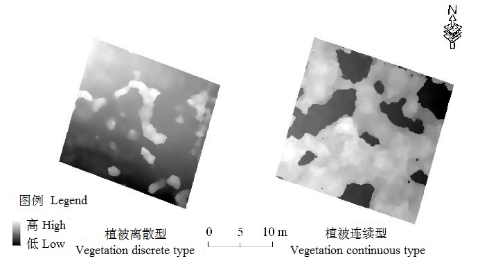
Fig. 2 Sample graph of vegetation types

Fig. 3 Flow chart of vegetation inversion technology
| 植被形态 Vegetation morphology | 树冠点提取结果 Canopy point extraction results | 地形反演结果 Terrain inversion results |
|---|---|---|
| 离散 Discrete | | |
| 连续 Continuous | | |
Table 1 Treatment results of typical sample plots
| 植被形态 Vegetation morphology | 树冠点提取结果 Canopy point extraction results | 地形反演结果 Terrain inversion results |
|---|---|---|
| 离散 Discrete | | |
| 连续 Continuous | | |
| 样地编号 Plot number | 植被形态 Vegetation morphology | 郁闭度 Canopy closure | 平均坡度 Average Slope/(°) | 地形起伏 Undulating Terrain/m | RMSEcloth/ m | RMSEmap/ m |
|---|---|---|---|---|---|---|
| 1 | 离散 Discrete | 0.081 | 9.466 | 4.947 | 0.303 | 0.584 |
| 2 | 离散 Discrete | 0.218 | 19.053 | 9.067 | 0.069 | 0.412 |
| 3 | 离散 Discrete | 0.323 | 22.268 | 10.06 | 0.067 | 0.355 |
| 4 | 离散 Discrete | 0.156 | 17.596 | 8.364 | 0.898 | 1.856 |
| 5 | 离散 Discrete | 0.248 | 22.404 | 10.065 | 0.107 | 0.995 |
| 6 | 连续 Continuous | 0.352 | 22.567 | 9.688 | 3.356 | 0.757 |
| 7 | 连续 Continuous | 0.27 | 15.779 | 5.17 | 1.547 | 0.210 |
| 8 | 连续 Continuous | 0.148 | 22.781 | 9.525 | 0.985 | 0.194 |
| 9 | 连续 Continuous | 0.482 | 5.341 | 2.606 | 3.528 | 0.918 |
| 10 | 离散 Discrete | 0.168 | 9.359 | 6.667 | 0.761 | 1.133 |
| 11 | 连续 Continuous | 0.482 | 18.676 | 15.014 | 2.857 | 0.681 |
| 12 | 离散 Discrete | 0.302 | 17.617 | 8.163 | 0.775 | 1.756 |
| 13 | 离散 Discrete | 0.178 | 19.872 | 9.134 | 0.222 | 0.574 |
| 14 | 连续 Continuous | 0.445 | 5.844 | 2.199 | 1.894 | 0.348 |
Table 2 Plot information and topography
| 样地编号 Plot number | 植被形态 Vegetation morphology | 郁闭度 Canopy closure | 平均坡度 Average Slope/(°) | 地形起伏 Undulating Terrain/m | RMSEcloth/ m | RMSEmap/ m |
|---|---|---|---|---|---|---|
| 1 | 离散 Discrete | 0.081 | 9.466 | 4.947 | 0.303 | 0.584 |
| 2 | 离散 Discrete | 0.218 | 19.053 | 9.067 | 0.069 | 0.412 |
| 3 | 离散 Discrete | 0.323 | 22.268 | 10.06 | 0.067 | 0.355 |
| 4 | 离散 Discrete | 0.156 | 17.596 | 8.364 | 0.898 | 1.856 |
| 5 | 离散 Discrete | 0.248 | 22.404 | 10.065 | 0.107 | 0.995 |
| 6 | 连续 Continuous | 0.352 | 22.567 | 9.688 | 3.356 | 0.757 |
| 7 | 连续 Continuous | 0.27 | 15.779 | 5.17 | 1.547 | 0.210 |
| 8 | 连续 Continuous | 0.148 | 22.781 | 9.525 | 0.985 | 0.194 |
| 9 | 连续 Continuous | 0.482 | 5.341 | 2.606 | 3.528 | 0.918 |
| 10 | 离散 Discrete | 0.168 | 9.359 | 6.667 | 0.761 | 1.133 |
| 11 | 连续 Continuous | 0.482 | 18.676 | 15.014 | 2.857 | 0.681 |
| 12 | 离散 Discrete | 0.302 | 17.617 | 8.163 | 0.775 | 1.756 |
| 13 | 离散 Discrete | 0.178 | 19.872 | 9.134 | 0.222 | 0.574 |
| 14 | 连续 Continuous | 0.445 | 5.844 | 2.199 | 1.894 | 0.348 |
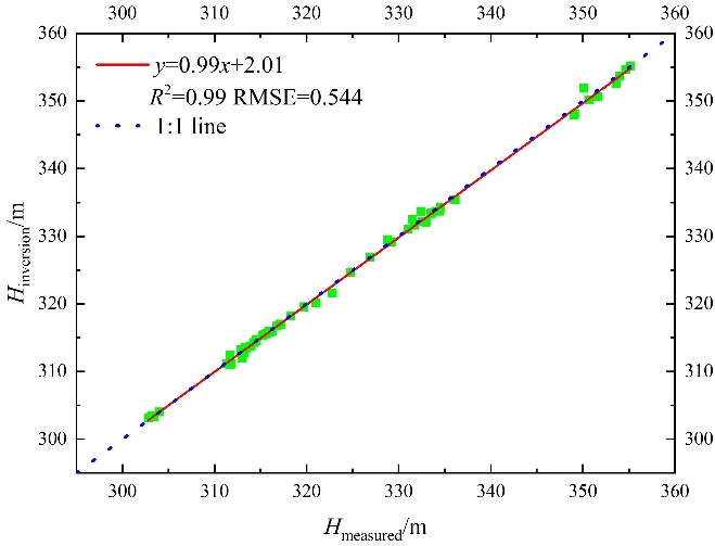
Fig. 4 Accuracy of terrain inversion
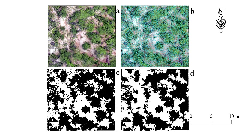
Fig. 5 Calculation of understory vegetation coverage The black area represents the plant area, and the white area represents the bare land area
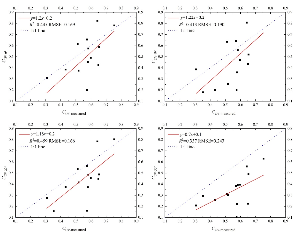
Fig. 6 Linear regression results of each angle
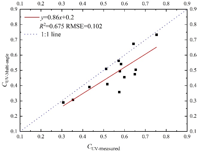
Fig. 7 Multi angle linear regression results of UVC
| [1] |
ACHANTA R, SHAJI A, SMITH K, et al., 2012. SLIC superpixels compared to state-of-the-art superpixel methods[J]. IEEE transactions on pattern analysis and machine intelligence, 34(11): 2274-2282.
DOI URL |
| [2] |
ANDERSON C T, DIETZ S L, POKSWINSKI S M, et al., 2021. Traditional field metrics and terrestrial LiDAR predict plant richness in southern pine forests[J]. Forest Ecology and Management, DOI: 10.1016/j.foreco.2021.119118.
DOI |
| [3] |
CHEN Y Q, ZHANG Y, YU S Q, et al., 2021. Responses of soil labile organic carbon and water-stable aggregates to reforestation in southern subtropical China[J]. Journal of Plant Ecology, 14(2): 191-201.
DOI URL |
| [4] |
FORREST G H, THOMAS H, NICHOLAS C C, et al., 2008. Multi-angle remote sensing of forest light use efficiency by observing PRI variation with canopy shadow fraction[J]. Remote Sensing of Environment, 112(7): 3201-3211.
DOI URL |
| [5] |
HARTLEY R J L, LEONARDO E M, MASSAM P et al., 2020. An Assessment of High-Density UAV Point Clouds for the Measurement of Young Forestry Trials[J]. Remote Sensing, DOI: 10.3390/rs12244039.
DOI |
| [6] |
KLÁPŠTĚ P, FOGL M, BARTÁK V, et al., 2020. Sensitivity analysis of parameters and contrasting performance of ground filtering algorithms with UAV photogrammetry-based and LiDAR point clouds[J]. International Journal of Digital Earth, 13(12): 1672-1694.
DOI URL |
| [7] |
LIN L C, YU K Y, YAO X, et al., 2021. UAV Based Estimation of Forest Leaf Area Index (LAI) through Oblique Photogrammetry[J]. Remote Sensing, 13(4): 803.
DOI URL |
| [8] |
LI L Y, CHEN J, MU X H, et al., 2020. Quantifying Understory and Overstory Vegetation Cover Using UAV-Based RGB Imagery in Forest Plantation[J]. Remote Sensing, 12(2): 298.
DOI URL |
| [9] |
LI L Y, MU X H, MACFARLANE C, et al., 2018. A half-Gaussian fitting method for estimating fractional vegetation cover of corn crops using unmanned aerial vehicle images[J]. Agricultural and Forest Meteorology, 262: 379-390.
DOI URL |
| [10] |
MAALEK R, 2021. Field information modeling (FIM)TM: Best practices using point clouds[J]. Remote Sensing, DOI: 10.3390/rs13050967.
DOI |
| [11] |
NA J M, XUE K K, XIONG L Y, et al., 2020. UAV-based terrain modeling under vegetation in the Chinese Loess Plateau: A deep learning and terrain correction ensemble framework[J]. Remote Sensing, DOI: 10.3390/rs12203318.
DOI |
| [12] | NIEDERHEISER R, WINKLER M, DI CECCO V, et al., 2021. Using automated vegetation cover estimation from close-range photogrammetric point clouds to compare vegetation location properties in mountain terrain[J]. GIScience & Remote Sensing, 58(1): 120-137. |
| [13] |
PANDEY S, KUMAR P, ZLATIC M, et al., 2021. Recent advances in assessment of soil erosion vulnerability in a watershed[J]. International Soil and Water Conservation Research, 9(3): 305-318.
DOI URL |
| [14] |
SHARDA V N, MANDAL D, DOGRA P, 2021. Prioritizing soil conservation measures based on water erosion risk and production and bio-energy losses in peninsular South Indian states[J]. Catena, DOI: 10.1016/j.catena.2021.105263.
DOI |
| [15] |
TOLGA G, 2019. Landslide recognition and mapping in a mixed forest environment from airborne LiDAR data[J]. Engineering Geology, DOI: 10.1016/j.enggeo.2019.105155.
DOI |
| [16] |
ZHANG W M, QI J B, PENG W, et al., 2016. An Easy-to-Use Airborne LiDAR Data Filtering Method Based on Cloth Simulation[J]. Remote Sensing, DOI: 10.3390/rs8060501.
DOI |
| [17] |
MENG X L, SHANG N, ZHANG X K, et al., 2017. Photogrammetric UAV Mapping of Terrain under Dense Coastal Vegetation: An Object-Oriented Classification Ensemble Algorithm for Classification and Terrain Correction[J]. Multidisciplinary Digital Publishing Institute, DOI: 10.3390/rs9111187.
DOI |
| [18] |
YAN Y J, DENG H Z, LIU Y et al., 2019. Application of UAV-based multi-angle hyperspectral remote sensing in fine vegetation classification[J]. Remote Sensing, 11(23): 2753.
DOI URL |
| [19] |
YANG L, RONGGAO L, JAN P, et al., 2017. Separating overstory and understory leaf area indices for global needleleaf and deciduous broadleaf forests by fusion of MODIS and MISR data[J]. Biogeosciences, 14(5): 1093-1110.
DOI URL |
| [20] |
YAO Y, LEUNG Y, FUNG T, et al., 2021. Continuous multi-angle remote sensing and its application in urban land cover classification[J]. Remote Sensing, DOI: 10.3390/rs13030413.
DOI |
| [21] |
YOLANDA S S, ANTONIO M, FERNANDO S F, et al., 2018. Mapping Wildfire Ignition Probability Using Sentinel 2 and LiDAR Jerte Valley, Cáceres, Spain[J]. Sensors, 18(3): 826.
DOI URL |
| [22] | 陈秋计, 杭梦如, 李继业, 等, 2020. 基于LIDAR的矿区恢复植被高度提取方法研究[J]. 煤炭科学技术, 48(4): 113-119. |
| CHEN Q J, HANG M R, LI J Y, et al., 2020. Extraction method of vegetation height in mining area based on lidar[J]. Coal science and technology, 48(4): 113-119. | |
| [23] | 韩文霆, 汤建栋, 张立元, 等, 2021. 基于无人机遥感玉米水分利用效率及生物量监测[J]. 农业机械学报, 52(5): 129-141. |
| HAN W T, TANG J D, ZHANG L Y, et al., 2021. Monitoring of water use efficiency and biomass of Maize Based on UAV Remote Sensing[J]. Transactions of the Chinese Society for Agricultural Machinery, 52(5): 129-141. | |
| [24] | 胡小芳, 李小雅, 赵红敏, 等, 2020. 民宿价格的空间分异特征及影响因素--以湖北省恩施州为例[J]. 自然资源学报, 35(10): 2473-2483. |
|
HU X F, LI X Y, ZHAO H M, et al., 2020. Spatial variation characteristics and influencing factors of homestay inn price: A case study of Enshi, Hubei[J]. Journal of natural resources, 35(10): 2473-2483.
DOI URL |
|
| [25] | 江海英, 贾坤, 赵祥, 等, 2020. 山地叶面积指数反演理论、方法与研究进展[J]. 遥感学报, 24(12): 1433-1449. |
| JIANG H Y, JIA K, ZHAO X, et al., 2020. Inversion theory, method and research progress of mountain leaf area index[J]. National Remote Sensing Bulletin, 24(12): 1433-1449. | |
| [26] |
焦桐, 刘荣高, 刘洋, 等, 2014. 林下植被遥感反演研究进展[J]. 地球信息科学学报, 16(4): 602-608.
DOI |
| JIAO T, LIU R G, LIU Y, et al., 2014. Advances in remote sensing inversion of understory vegetation[J]. Journal of Geo-information Science, 16(4): 602-608. | |
| [27] | 王敬哲, 陈志强, 陈志彪, 等, 2020. 南方红壤侵蚀区不同植被恢复年限下芒萁叶功能性状对土壤因子的响应[J]. 生态学报, 40(3): 900-909. |
| WANG J Z, CHEN Z Q, CHEN Z B, et al., 2020. Response of leaf functional traits of Osmunda japonica to soil factors under different vegetation restoration years in red soil erosion area of southern China[J]. Acta ecologica Sinica, 40(3): 900-909. | |
| [28] | 徐逸, 甄佳宁, 蒋侠朋, 等, 2021. 无人机遥感与XGBoost的红树林物种分类[J]. 遥感学报, 25(3): 737-752. |
| XU Y, ZHEN J N, JIANG X P, et al., 2021. Classification of mangrove species based on UAV remote sensing and xgboost[J]. National Remote Sensing Bulletin, 25(3): 737-752. | |
| [29] | 阎广建, 姜海兰, 闫凯, 等, 2021. 多角度光学定量遥感[J]. 遥感学报, 25(1): 83-108. |
| YAN G J, JIANG H L, YAN K, et al., 2021. Multi angle optical quantitative remote sensing[J]. National Remote Sensing Bulletin, 25(1): 83-108. | |
| [30] | 杨蜀秦, 宋志双, 尹瀚平, 等, 2021. 基于深度语义分割的无人机多光谱遥感作物分类方法[J]. 农业机械学报, 52(3): 185-192. |
| YANG S Q, SONG Z S, YIN H P, et al., 2021. Crop classification method based on depth semantic segmentation for UAV multispectral remote sensing[J]. Transactions of the Chinese Society for Agricultural Machinery, 52(3): 185-192. | |
| [31] | 张仓皓, 杨樟平, 谢巧雅, 等, 2020. 毛竹立竹度无人机遥感识别有效高度的研究[J]. 遥感技术与应用, 35(6): 1436-1446. |
| ZHANG C H, YANG Z P, XIE Q Y, et al., 2020. Study on effective height recognition of Phyllostachys pubescens based on UAV Remote Sensing[J]. Remote Sensing Technology and Application, 35(6): 1436-1446. | |
| [32] |
赵长森, 潘旭, 杨胜天, 等, 2019. 低空遥感无人机影像反演河道流量[J]. 地理学报, 74(7): 1392-1408.
DOI |
| ZHAO C S, PAN X, YANG S T, et al., 2019. Low altitude remote sensing UAV image retrieval of river flow[J]. Acta Geographica Sinica, 74(7): 1392-1408. |
| No related articles found! |
| Viewed | ||||||
|
Full text |
|
|||||
|
Abstract |
|
|||||
Website Copyright © 2021 Editorial Office of Ecology and Environmental Sciences
Add: 808# Tianyuan Road, Tianhe District, Guangzhou. 510650.
Institute of Eco-environmental and Soil Sciences, Guangdong Academy of Sciences
Tel/Fax: 020-87024961; E-mail: editor@jeesci.com
Support by Beijing Magtech Co. Ltd., E-mail: support@magtech.com.cn