
生态环境学报 ›› 2026, Vol. 35 ›› Issue (9): 1483-1494.DOI: 10.16258/j.cnki.1674-5906.2026.09.014
• 研究论文【环境科学】 •
上一篇
邹志琦1( ), 敦力民2, 王井利1,*(), 唐玉兰3
收稿日期:2025-06-04
修回日期:2026-05-14
接受日期:2026-07-31
出版日期:2026-09-18
发布日期:2026-09-16
通讯作者:
王井利, E-mail: 作者简介:邹志琦(2001年生),男(满族),硕士研究生,研究方向为高光谱遥感。E-mail: 2437432433@qq.com
基金资助:
Zou Zhiqi1(), Dun Limin2, Wang Jingli1,*(), Tang Yulan3
Received:2025-06-04
Revised:2026-05-14
Accepted:2026-07-31
Online:2026-09-18
Published:2026-09-16
摘要:
【目的】探讨利用低空无人机平台对污染区域土壤重金属铜(Cu)含量进行遥感估算的可行性,为污染场地快速评估与修复提供技术支撑,【方法】以辽宁省铁岭市银州区某废弃有色金属加工厂为研究区,提出一种结合光谱变换、特征波段筛选及光谱指数的土壤Cu含量定量反演方法。比较三类建模策略:4种二维光谱指数(2D)、4种三维植被光谱指数(3D-SI)和4种新三维光谱指数(3D-BI),并采用牛顿−拉夫逊优化极致梯度提升(NRBO-XGBoost)算法建立Cu含量反演模型。【结果】光谱变换显著提升光谱变量与Cu含量的相关性,其中一阶导数变换下ABI3(850,885,520)相关性最佳(−0.570)。同一预处理下,3D植被指数和新三维光谱指数与Cu含量的相关性及模型效果均优于2D光谱指数。NRBO-XGBoost结合FD-3D-SI数据集模型性能最优(R2=0.933,RMSE=75 mg·kg−1),显著优于XGBoost模型(R2=0.833,RMSE=116 mg·kg−1)。【结论】基于NRBO-XGBoost的无人机高光谱估算模型可快速预测研究区重金属污染并实现区域填图,证实了无人机高光谱数据在重金属污染监测中的潜力,可为污染场地的高效评估与修复提供有效技术手段。
中图分类号:
邹志琦, 敦力民, 王井利, 唐玉兰. 基于NRBO−XGBoost优化无人机高光谱土壤重金属铜(Cu)含量反演研究[J]. 生态环境学报, 2026, 35(9): 1483-1494.
Zou Zhiqi, Dun Limin, Wang Jingli, Tang Yulan. Optimization of UAV Hyperspectral Retrieval of Soil Copper (Cu) Content Using NRBO-XGBoost[J]. Ecology and Environmental Sciences, 2026, 35(9): 1483-1494.

图1 研究区位置及采样点分布 该图中辽宁省基于自然资源部标准地图服务网站下载的审图号为GS(2024)0650号的标准地图制作底图边界无修改
Figure 1 Location of the study area and distribution of sampling points

图2 实验流程图
Figure 2 Experimental flow chart
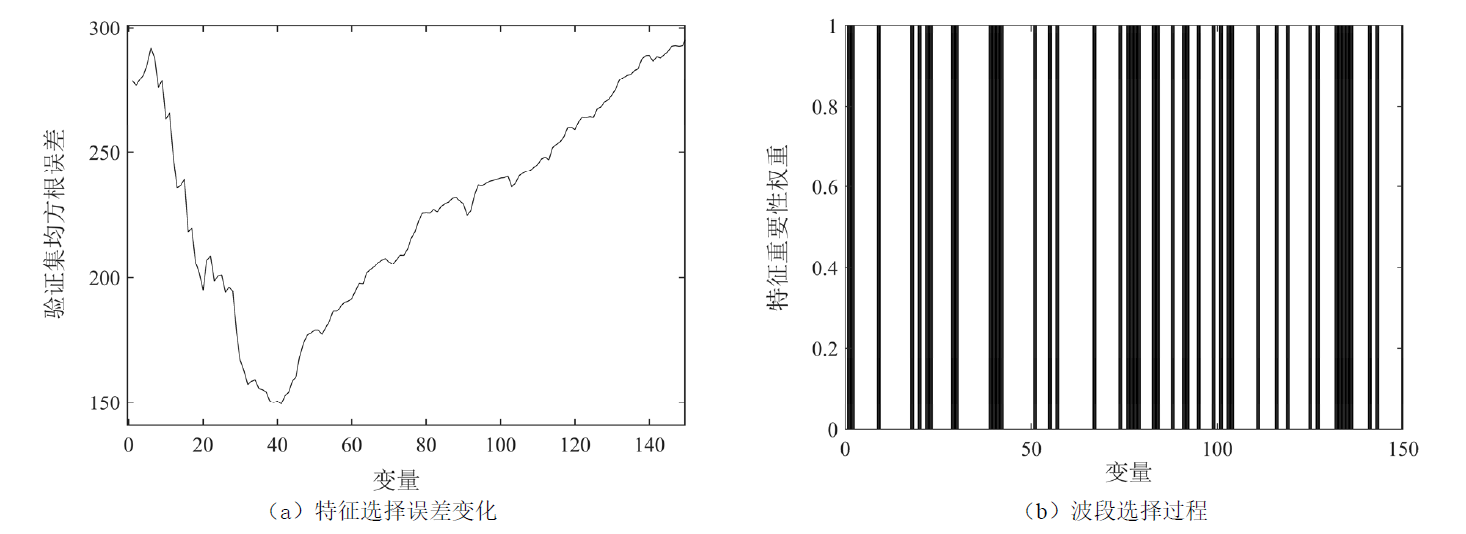
图3 VISSA特征选择过程
Figure 3 VISSA feature selection process

图4 2D光谱指数相关性等势图
Figure 4 2D spectral index correlation contour map
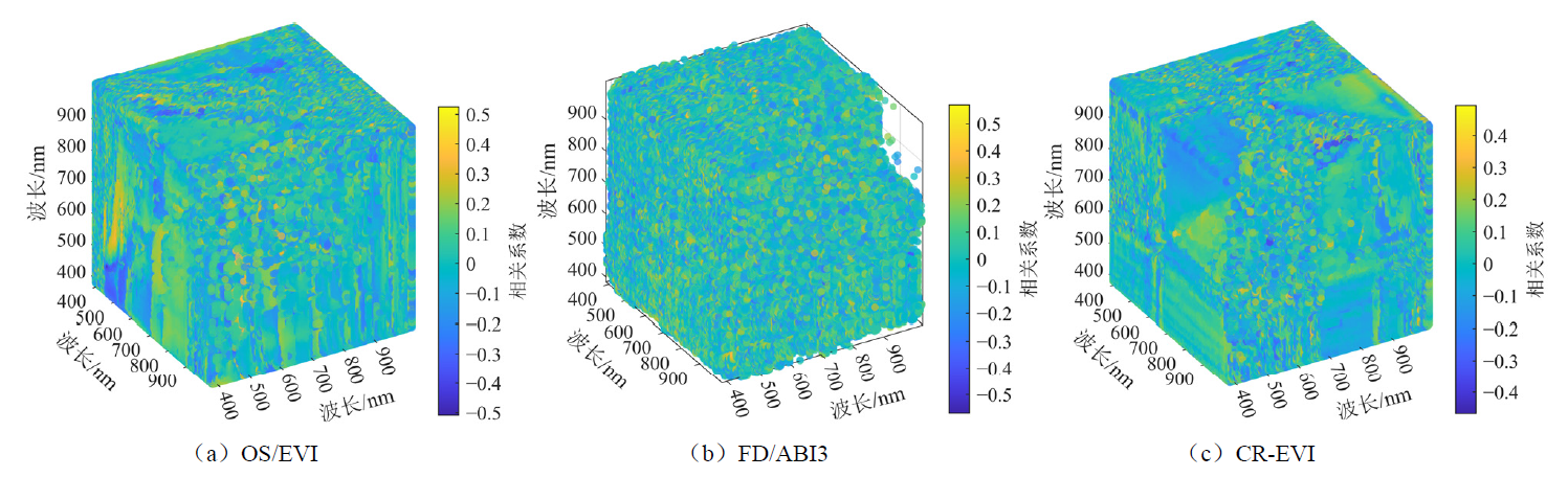
图5 3D光谱指数相关性等势图
Figure 5 3D spectral index and correlation contour map
| 光谱指数 | 波段组合/nm | 最佳相关系数 |
|---|---|---|
| NDVI | 466,470 | 0.322 |
| RSI | 894,988 | 0.328 |
| DSI | 466,470 | 0.323 |
| SAVI | 466,470 | −0.322 |
| EVI | 524,458,561 | 0.524 |
| NSI | 385,466,475 | 0.361 |
| SIPI | 549,385,558 | −0.491 |
| TSI | 495,483,466 | −0.451 |
| ABI1 | 458,574,512 | −0.506 |
| ABI2 | 466,483,491 | −0.432 |
| ABI3 | 483,495,458 | −0.496 |
| ABI4 | 466,475,898 | −0.341 |
表1 SG后最佳波段组合与相关系数
Table 1 Best band combination and correlation coefficient after SG
| 光谱指数 | 波段组合/nm | 最佳相关系数 |
|---|---|---|
| NDVI | 466,470 | 0.322 |
| RSI | 894,988 | 0.328 |
| DSI | 466,470 | 0.323 |
| SAVI | 466,470 | −0.322 |
| EVI | 524,458,561 | 0.524 |
| NSI | 385,466,475 | 0.361 |
| SIPI | 549,385,558 | −0.491 |
| TSI | 495,483,466 | −0.451 |
| ABI1 | 458,574,512 | −0.506 |
| ABI2 | 466,483,491 | −0.432 |
| ABI3 | 483,495,458 | −0.496 |
| ABI4 | 466,475,898 | −0.341 |
| 光谱指数 | 波段组合/nm | 最佳相关系数 |
|---|---|---|
| NDVI | 642,802 | 0.484 |
| RSI | 454,466 | 0.438 |
| DSI | 537,470 | 0.425 |
| SAVI | 553,470 | 0.484 |
| EVI | 802,397,553 | −0.544 |
| NSI | 446,553,483 | 0.455 |
| SIPI | 993,454,881 | 0.535 |
| TSI | 454,470,553 | −0.544 |
| ABI1 | 553,650,446 | −0.307 |
| ABI2 | 553,470,591 | −0.528 |
| ABI3 | 850,885,520 | −0.570 |
| ABI4 | 780,890,997 | 0.560 |
表2 FD后最佳波段组合与相关系数
Table 2 Best band combination and correlation coefficient after FD
| 光谱指数 | 波段组合/nm | 最佳相关系数 |
|---|---|---|
| NDVI | 642,802 | 0.484 |
| RSI | 454,466 | 0.438 |
| DSI | 537,470 | 0.425 |
| SAVI | 553,470 | 0.484 |
| EVI | 802,397,553 | −0.544 |
| NSI | 446,553,483 | 0.455 |
| SIPI | 993,454,881 | 0.535 |
| TSI | 454,470,553 | −0.544 |
| ABI1 | 553,650,446 | −0.307 |
| ABI2 | 553,470,591 | −0.528 |
| ABI3 | 850,885,520 | −0.570 |
| ABI4 | 780,890,997 | 0.560 |
| 光谱指数 | 波段组合/nm | 最佳相关系数 |
|---|---|---|
| NDVI | 625,570 | 0.342 |
| RSI | 723,719 | 0.337 |
| DSI | 625,570 | 0.333 |
| SAVI | 723,710 | 0.354 |
| EVI | 854,642,650 | 0.494 |
| NSI | 625,1020,389 | 0.395 |
| SIPI | 655,574,961 | 0.446 |
| TSI | 702,710,723 | −0.370 |
| ABI1 | 625,659,579 | −0.356 |
| ABI2 | 541,579,625 | −0.367 |
| ABI3 | 566,562,1002 | 0.453 |
| ABI4 | 710,723,591 | 0.376 |
表3 CR后最佳波段组合与相关系数
Table 3 Best band combination after CR and correlation coefficient
| 光谱指数 | 波段组合/nm | 最佳相关系数 |
|---|---|---|
| NDVI | 625,570 | 0.342 |
| RSI | 723,719 | 0.337 |
| DSI | 625,570 | 0.333 |
| SAVI | 723,710 | 0.354 |
| EVI | 854,642,650 | 0.494 |
| NSI | 625,1020,389 | 0.395 |
| SIPI | 655,574,961 | 0.446 |
| TSI | 702,710,723 | −0.370 |
| ABI1 | 625,659,579 | −0.356 |
| ABI2 | 541,579,625 | −0.367 |
| ABI3 | 566,562,1002 | 0.453 |
| ABI4 | 710,723,591 | 0.376 |
| 数据集 | 样本数量(n) | 平均值/ (mg·kg−1) | 标准差/ (mg·kg−1) | 变异系数(CV) |
|---|---|---|---|---|
| 训练集 | 50 | 885 | 215 | 0.243 |
| 测试集 | 13 | 868 | 199 | 0.229 |
| 全体样本 | 63 | 881 | 210 | 0.241 |
表4 训练集与测试集土壤重金属Cu含量统计特征对比
Table 4 Comparison of statistical characteristics of soil heavy metal Cu content in training and test sets
| 数据集 | 样本数量(n) | 平均值/ (mg·kg−1) | 标准差/ (mg·kg−1) | 变异系数(CV) |
|---|---|---|---|---|
| 训练集 | 50 | 885 | 215 | 0.243 |
| 测试集 | 13 | 868 | 199 | 0.229 |
| 全体样本 | 63 | 881 | 210 | 0.241 |
| 数据源 | 建模方法 | 训练集R2 | 训练集σRMSE | 测试集R2 | 测试集σRMSE |
|---|---|---|---|---|---|
| SG+2D 指数 | XGBoost | 0.600 | 196 | 0.305 | 236 |
| NRBO-XGBoost | 0.642 | 178 | 0.412 | 221 | |
| SG-FD+ 2D指数 | XGBoost | 0.785 | 135 | 0.435 | 211 |
| NRBO-XGBoost | 0.816 | 123 | 0.515 | 201 | |
| SG-CR+ 2D指数 | XGBoost | 0.806 | 240 | 0.443 | 236 |
| NRBO-XGBoost | 0.844 | 222 | 0.352 | 188 | |
| SG+植被 指数 | XGBoost | 0.769 | 138 | 0.618 | 187 |
| NRBO-XGBoost | 0.877 | 104 | 0.633 | 176 | |
| SG-FD+ 植被指数 | XGBoost | 0.833 | 116 | 0.570 | 213 |
| NRBO-XGBoost | 0.933 | 75 | 0.725 | 163 | |
| SG-CR+ 植被指数 | XGBoost | 0.577 | 241 | 0.340 | 281 |
| NRBO-XGBoost | 0.788 | 133 | 0.357 | 256 | |
| SG+新指数 | XGBoost | 0.562 | 154 | 0.433 | 253 |
| NRBO-XGBoost | 0.757 | 147 | 0.454 | 212 | |
| SG-FD+ 新指数 | XGBoost | 0.805 | 121 | 0.404 | 266 |
| NRBO-XGBoost | 0.898 | 95 | 0.655 | 148 | |
| SG-CR+ 新指数 | XGBoost | 0.683 | 179 | 0.423 | 223 |
| NRBO-XGBoost | 0.735 | 157 | 0.650 | 171 |
表5 3种数据集不同预处理在两种模型下的预测精度
Table 5 Prediction accuracy of the three datasets with different preprocessing under the two models
| 数据源 | 建模方法 | 训练集R2 | 训练集σRMSE | 测试集R2 | 测试集σRMSE |
|---|---|---|---|---|---|
| SG+2D 指数 | XGBoost | 0.600 | 196 | 0.305 | 236 |
| NRBO-XGBoost | 0.642 | 178 | 0.412 | 221 | |
| SG-FD+ 2D指数 | XGBoost | 0.785 | 135 | 0.435 | 211 |
| NRBO-XGBoost | 0.816 | 123 | 0.515 | 201 | |
| SG-CR+ 2D指数 | XGBoost | 0.806 | 240 | 0.443 | 236 |
| NRBO-XGBoost | 0.844 | 222 | 0.352 | 188 | |
| SG+植被 指数 | XGBoost | 0.769 | 138 | 0.618 | 187 |
| NRBO-XGBoost | 0.877 | 104 | 0.633 | 176 | |
| SG-FD+ 植被指数 | XGBoost | 0.833 | 116 | 0.570 | 213 |
| NRBO-XGBoost | 0.933 | 75 | 0.725 | 163 | |
| SG-CR+ 植被指数 | XGBoost | 0.577 | 241 | 0.340 | 281 |
| NRBO-XGBoost | 0.788 | 133 | 0.357 | 256 | |
| SG+新指数 | XGBoost | 0.562 | 154 | 0.433 | 253 |
| NRBO-XGBoost | 0.757 | 147 | 0.454 | 212 | |
| SG-FD+ 新指数 | XGBoost | 0.805 | 121 | 0.404 | 266 |
| NRBO-XGBoost | 0.898 | 95 | 0.655 | 148 | |
| SG-CR+ 新指数 | XGBoost | 0.683 | 179 | 0.423 | 223 |
| NRBO-XGBoost | 0.735 | 157 | 0.650 | 171 |
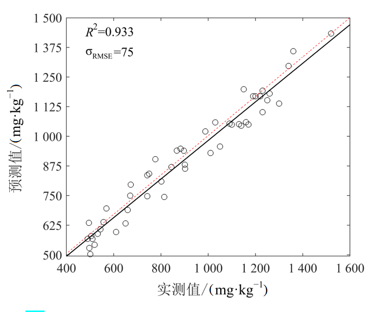
图6 OS-FD-3D-SI数据集在NRBO-XGBoost优化模型中的精度
Figure 6 Accuracy of the OS-FD-3D-SI dataset in the NRBO-XGBoost optimization model

图7 预测Cu含量空间分布
Figure 7 Predicted spatial distribution of Cu content
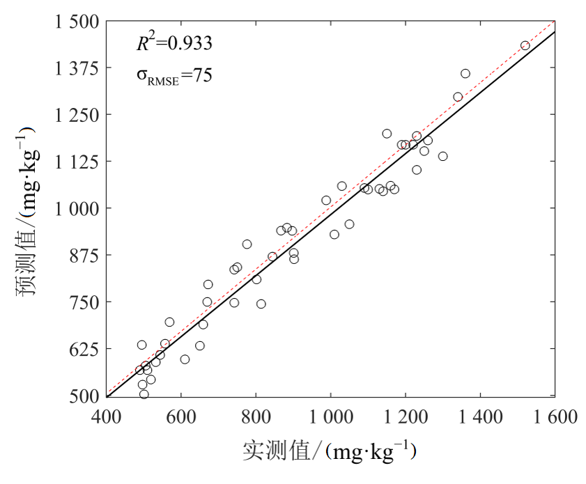
图8 土壤重金属Cu含量反演结果验证精度图
Figure 8 Accuracy diagram of the inversion results of heavy metal Cu content in soil
| [1] |
Bao Y L, Ustin S, Meng X T, et al., 2021. A regional-scale hyperspectral prediction model of soil organic carbon considering geomorphic features[J]. Geoderma, 403: 115263.
DOI URL |
| [2] |
Deng B C, Yun Y H, Liang Y Z, 2015. Model population analysis in chemometrics[J]. Chemometrics and Intelligent Laboratory Systems, 149: 166-176.
DOI URL |
| [3] |
Dong Y, Wang X T, Wang S, et al., 2025. Enhancing soil organic carbon prediction by unraveling the role of crop residue coverage using interpretable machine learning[J]. Geoderma, 455: 117225.
DOI URL |
| [4] |
Fang H, Man W D, Liu M Y, et al., 2023. Leaf area index inversion of spartina alterniflora using UAV hyperspectral data based on multiple optimized machine learning algorithms[J]. Remote Sensing, 15(18): 4465.
DOI URL |
| [5] |
Geng J, Lü J W, Pei J, et al., 2024. Prediction of soil organic carbon in black soil based on a synergistic scheme from hyperspectral data: Combining fractional-order derivatives and three-dimensional spectral indices[J]. Computers and Electronics in Agriculture, 220: 108905.
DOI URL |
| [6] |
Guo B, Guo X N, Zhang B, et al., 2022. Using a Two-Stage Scheme to Map Toxic Metal Distributions Based on GF-5 Satellite Hyperspectral Images at a Northern Chinese Opencast Coal Mine[J]. Remote Sensing, 14(22): 5804.
DOI URL |
| [7] |
He P, Cheng X F, Wen X P, et al., 2025. Improving soil heavy metal lead inversion through combined band selection methods: A case study in Gejiu city, China[J]. Sensors, 25(3): 684.
DOI URL |
| [8] |
Huang F, Peng S Y, Yang H, et al., 2022. Development of a novel and fast XRF instrument for large area heavy metal detection integrated with UAV[J]. Environmental Research, 214(Part 2): 113841.
DOI URL |
| [9] |
Li Y R, Liu B, Chai X, et al., 2025. Research on shallow water depth remote sensing based on the improvement of the newton-raphson optimizer[J]. Water, 17(4): 552.
DOI URL |
| [10] | Lu B, Sun J, Yang N, et al., 2019. Fluorescence hyperspectral image technique coupled with HSI method to predict solanine content of potatoes[J]. Journal of Food Processing and Preservation, 43(11): e1419. |
| [11] |
Lu Q K, Si W, Wei L F, et al., 2021. Retrieval of water quality from UAV-Borne hyperspectral imagery: A comparative study of machine learning algorithms[J]. Remote Sensing, 13(19): 3928.
DOI URL |
| [12] |
Ma C Y, Liu X, Li S Q, et al., 2023. Accuracy evaluation of hyperspectral inversion of environmental parameters of loess profile[J]. Environmental Earth Sciences, 82(10): 251.
DOI |
| [13] | Magreñán Á A, Argyros I K, 2018. A contemporary study of iterative methods: Convergence, dynamics and applications[M]. New York: Academic Press. |
| [14] |
Mahanty B, 2019. Efficient variable selection algorithm adopting variance inflated resampling weight vector into model population analysis[J]. Journal of Chemometrics, 33(2): e3099.
DOI URL |
| [15] |
Premkumar M, Jangir P, Sowmya R, 2021. MOGBO: A new Multiobjective Gradient-Based Optimizer for real-world structural optimization problems[J]. Knowledge-Based Systems, 218: 106856.
DOI URL |
| [16] |
Sowmya R, Premkumar M, Jangir P, 2024. Newton-Raphson-based optimizer: A new population-based metaheuristic algorithm for continuous optimization problems[J]. Engineering Applications of Artificial Intelligence, 128: 107532.
DOI URL |
| [17] |
Sun W C, Zhang X, Sun X J, et al., 2018. Predicting nickel concentration in soil using reflectance spectroscopy associated with organic matter and clay minerals[J]. Geoderma, 327: 25-35.
DOI URL |
| [18] |
Tan J, Ding J L, Wang Z Y, et al., 2024. Estimating soil salinity in mulched cotton fields using UAV-based hyperspectral remote sensing and a Seagull Optimization Algorithm-Enhanced Random Forest Model[J]. Computers and Electronics in Agriculture, 221: 109017.
DOI URL |
| [19] |
Tan K, Ma W B, Chen L H, et al., 2021. Estimating the distribution trend of soil heavy metals in mining area from HyMap airborne hyperspectral imagery based on ensemble learning[J]. Journal of Hazardous Materials, 401: 123288.
DOI URL |
| [20] |
Wei L F, Pu H C, Wang Z X, et al., 2020. Estimation of soil arsenic content with hyperspectral remote sensing[J]. Sensors, 20(14): 4056.
DOI URL |
| [21] |
Zhang F, Li X Y, Zhou X H, et al., 2023. Retrieval of soil salinity based on multi-source remote sensing data and differential transformation technology[J]. International Journal of Remote Sensing, 44(4): 1348-1368.
DOI URL |
| [22] |
Zhang Y, Yang Y Z, Zhang Q W, et al., 2023. Toward multi-stage phenotyping of soybean with multimodal UAV sensor data: A comparison of machine learning approaches for leaf area index estimation[J]. Remote Sensing, 15(1): 7.
DOI URL |
| [23] |
Zhou X H, Zhang F, Liu C J, et al., 2021. Soil salinity inversion based on novel spectral index[J]. Environmental Earth Sciences, 80(16): 501.
DOI |
| [24] |
Zhu C M, Zhang Z P, Wang H W, et al., 2020. Assessing soil organic matter content in a coal mining area through spectral variables of different numbers of dimensions[J]. Sensors, 20(6): 179.
DOI URL |
| [25] |
Zhu Y H, Liu K, Liu L, et al., 2017. Exploring the Potential of WorldView-2 Red-Edge Band-Based Vegetation Indices for Estimation of Mangrove Leaf Area Index with Machine Learning Algorithms[J]. Remote Sensing, 9(10): 1060.
DOI URL |
| [26] |
Zhuo W, Wu N, Shi R H, et al., 2024. Aboveground biomass retrieval of wetland vegetation at the species level using UAV hyperspectral imagery and machine learning[J]. Ecological Indicators, 166: 112365.
DOI URL |
| [27] | 陈晓凯, 李粉玲, 王玉娜, 等, 2020. 无人机高光谱遥感估算冬小麦叶面积指数[J]. 农业工程学报, 36(22): 40-49. |
| Chen X K, Li F L, Wang Y N, et al., 2020. Estimation of winter wheat leaf area index by UAV hyperspectral remote sensing[J]. Transactions of the Chinese Society of Agricultural Engineering, 36(22): 40-49. | |
| [28] | 陈银梦, 詹倩, 2019. 运用双样本t检验的若干误区与正确条件[J]. 统计与管理 (2): 40-42. |
| Chen Y M, Zhan Q, 2019. Several misunderstandings and correct conditions of applying two-sample t-test[J]. Statistics and Management (2): 40-42. | |
| [29] | 程俊恺, 冯秀丽, 陈立波, 等, 2024. 基于无人机高光谱数据的耕地土壤盐分反演模型优选[J]. 应用生态学报, 35(11): 3085-3094. |
| Cheng J K, Feng X L, Chen L B, et al., 2024. Optimization of inversion models for cultivated land soil salinity based on UAV hyperspectral data[J]. Chinese Journal of Applied Ecology, 35(11): 3085-3094. | |
| [30] | 呼斯乐, 包玉龙, 图布新巴雅尔, 等, 2025. 基于无人机高光谱和集成学习的春小麦叶绿素含量反演[J]. 中国农业科技导报(中英文), 27(6): 93-103. |
| Husile, Bao Y L, Tubuxinbayar, et al., 2025. Chlorophyll content inversion of spring wheat based on UAV hyperspectral and ensemble learning[J]. Journal of Agricultural Science and Technology, 27(6): 93-103. | |
| [31] | 刘潜, 王梦迪, 郭龙, 等, 2024. 基于机载高光谱影像的农田尺度土壤有机碳密度制图[J]. 遥感学报, 28(1): 293-305. |
| Liu Q, Wang M D, Guo L, et al., 2024. Mapping of soil organic carbon density at farmland scale based on airborne hyperspectral imagery[J]. Journal of Remote Sensing, 28(1): 293-305. | |
| [32] | 生态环境部, 2018. 土壤环境质量建设用地土壤污染风险管控标准 (试行): GB 36600—2018[S]. 北京: 中国环境出版社: 3. |
| Ministry of Ecology and Environment, 2018. Soil environmental quality-Risk control standard for soil contamination of development land (Trial): GB 36600—2018[S]. Beijing: China Environment Publishing Group Co., Ltd.: 3. | |
| [33] | 圣超, 苏敦雷, 2025. 土壤重金属污染治理策略研究[J]. 皮革制作与环保科技, 6(5): 123-125. |
| Sheng C, Su D L, 2025. Research on remediation strategies for soil heavy metal pollution[J]. Leather Making and Environmental Technology, 6(5): 123-125. | |
| [34] | 孙小添, 王海超, 韩青池, 等, 2025. 应用无人机遥感数据估算沙柳灌丛地上生物量的方法[J]. 东北林业大学学报, 53(5): 74-81. |
| Sun X T, Wang H C, Han Q C, et al., 2025. Method for estimating aboveground biomass of Salix cheilophila shrub based on UAV remote sensing data[J]. Journal of Northeast Forestry University, 53(5): 74-81. | |
| [35] | 涂宇龙, 邹滨, 姜晓璐, 等, 2018. 矿区土壤Cu含量高光谱反演建模[J]. 光谱学与光谱分析, 38(2): 575-581. |
| Tu Y L, Zou B, Jiang X L, et al., 2018. Hyperspectral inversion modeling of soil Cu content in mining areas[J]. Spectroscopy and Spectral Analysis, 38(2): 575-581. | |
| [36] |
王萌, 李杉杉, 李晓越, 等, 2018. 我国土壤中铜的污染现状与修复研究进展[J]. 地学前缘, 25(5): 305-313.
DOI |
| Wang M, Li S S, Li X Y, et al., 2018. Pollution status and remediation research progress of copper in soil in China[J]. Earth Science Frontiers, 25(5): 305-313. | |
| [37] | 肖学祥, 2025. 小麦病虫害监测及无人机精准防控技术[J]. 新疆农机化 (2): 26-28. |
| Xiao X X, 2025. Monitoring of wheat diseases and insect pests and UAV precise prevention and control technology[J]. Xinjiang Agricultural Mechanization (2): 26-28. | |
| [38] | 张雨婷, 齐欣宇, 2025. 土壤重金属污染:环境风险与治理策略[J]. 实验室检测, 3(8): 146-148. |
| Zhang Y T, Qi X Y, 2025. Soil heavy metal pollution: environmental risks and remediation strategies[J]. Laboratory Testing, 3(8): 146-148. | |
| [39] | 张紫玥, 刘晓, 杜丽丽, 等, 2025. 基于随机蛙跳降维和PSO-BPNN的高光谱水体总氮遥感反演[J]. 激光与光电子学进展, 62(17): 97-106. |
| Zhang Z Y, Liu X, Du L L, et al., 2025. Hyperspectral remote sensing inversion of total nitrogen in water based on random frog dimensionality reduction and PSO-BPNN[J]. Laser & Optoelectronics Progress, 62(17): 97-106. |
| [1] | 万翔, 严思琪, 严森, 谢淑云, 向武, 谭文峰. 基于地球化学调查的丹江口库区土壤氮磷流失风险评估[J]. 生态环境学报, 2026, 35(9): 1381-1392. |
| [2] | 徐玉静, 杨昊, 于泓, 柴钰莹. 珠江三角洲海岸带蓝碳储量时空演变特征及驱动因素分析[J]. 生态环境学报, 2026, 35(8): 1163-1175. |
| [3] | 梁淼, 向云, 陆倩. 农业经济高质量发展-产业升级-碳减排的动态耦合与交互响应机制研究[J]. 生态环境学报, 2026, 35(8): 1187-1198. |
| [4] | 张卫红, 宫燕, 韩增玉, 刘志鹏, 杨若杼, 马娟, 林乃峰, 田峰. 融合生态系统服务与生态管控单元的生态安全格局构建——以宁夏回族自治区为例[J]. 生态环境学报, 2026, 35(8): 1209-1220. |
| [5] | 王道远, 赵宁, 刘平新, 焦桂权, 黄聿铭, 李小慧. 太行山区生态系统服务权衡协同特征及分区管控研究[J]. 生态环境学报, 2026, 35(8): 1221-1233. |
| [6] | 汪丽妍, 曹玮, 罗云建, 张德顺. 长三角城市群城市蓝绿空间景观格局对生态利用效率的影响研究[J]. 生态环境学报, 2026, 35(8): 1234-1245. |
| [7] | 姚旭兵, 张玲, 车四方, 邓晓霞. 数字乡村建设对农业生态效率的影响研究[J]. 生态环境学报, 2026, 35(7): 1045-1058. |
| [8] | 周家豪, 张沛, 彭煜文, 钟松雄, 邹建平, 侯冬梅. 基于机器学习识别赣江流域重金属污染主控因素[J]. 生态环境学报, 2026, 35(6): 976-985. |
| [9] | 石洪飞, 侯光良, 曹明珠, 关佳萌, 何家豪, 唐中华, 马曙光. 基于InVEST模型的三江源黄河流域水源涵养时空演变与驱动机制[J]. 生态环境学报, 2026, 35(5): 793-804. |
| [10] | 秦群策, 李连伟, 郑直. 基于SRP模型的青岛市生态脆弱性时空演变分析[J]. 生态环境学报, 2026, 35(4): 540-550. |
| [11] | 杜嘉睿, 宋芊, 高文明. 黄河源区生态系统健康时空演变与多情景模拟研究[J]. 生态环境学报, 2026, 35(4): 551-562. |
| [12] | 何定学, 郝帅, 李国华, 蒋晓晴, 冯中丽. 艾比湖主要入湖河流稳定同位素特征及水体蒸发比例研究[J]. 生态环境学报, 2026, 35(4): 598-609. |
| [13] | 李家蔚, 黄凯, 李盛泽, 董路, 于相毅, 毛岩, 孟耀斌. SWAT-KM环境暴露模拟支持下的滇池流域邻苯二甲酸二辛酯生态风险研判[J]. 生态环境学报, 2026, 35(3): 362-377. |
| [14] | 徐龙龙, 陈晓玲, 谢团辉, 姜超, 徐波, 石振华, 陈炎辉. 基于MaxEnt模型预测加拿大一枝黄花在福建的潜在入侵风险区[J]. 生态环境学报, 2026, 35(3): 414-424. |
| [15] | 张煜坤, 陈懂懂, 李奇, 贺福全, 张莉, 赵亮. 基于多元统计分析和PMF模型的土壤重金属源解析——以三江源为例[J]. 生态环境学报, 2026, 35(3): 458-468. |
| 阅读次数 | ||||||
|
全文 |
|
|||||
|
摘要 |
|
|||||
