生态环境学报 ›› 2025, Vol. 34 ›› Issue (1): 135-144.DOI: 10.16258/j.cnki.1674-5906.2025.01.015
刘振江1( ), 王正2, 曹玉洁3, 蔡姝崴3, 陈伟3,*(), 路凯丽3
收稿日期:2024-09-04
出版日期:2025-01-18
发布日期:2025-01-21
通讯作者:
* 陈伟。E-mail: 13752220829@163.com作者简介:刘振江(1975年生),男,教授,硕士,研究方向为机场鸟击防范。E-mail: macrop@163.com
基金资助:
LIU Zhenjiang1(), WANG Zheng2, CAO Yujie3, CAI Shuwei3, CHEN Wei3,*(), LU Kaili3
Received:2024-09-04
Online:2025-01-18
Published:2025-01-21
摘要:
选取我国东部沿海某机场周围8 km范围作为调查区域,根据土地类型进行样线与样点调查法,全年记录到140种鸟类数据。通过对影响鸟击的显性条件和隐性条件分析,确定鸟类集群数量、平均体质量、飞行高度、网捕数量、飞行速度等5个指标为风险评价指标,建立鸟击风险评价指标体系,借助各指标数据特征以区间形式制定等级划分标准。针对鸟情数据冗余与极端值情况,对传统的CRITIC法和云模型法进行改进,得到改进CRITIC-云模型法,并运用到机场鸟击风险评价中。结合鸟类指标数据与传统CRITIC-云模型法和传统CRITIC-云模型L法(传统云模型法)评价结果进行对比分析,发现改进CRITIC-云模型法避免了模型受单个等级区间的影响,能够全面性、综合性评价鸟类的风险等级,评价结果更加准确,与鸟击风险评价方面适配性更高。确定风险评价等级IV级与V级的鸟类为高危鸟种,共26种,其中1种为国家一级重点野生保护动物,5种为国家二级重点野生保护动物。通过对高危鸟种活动环境进行分析,将其归纳为海洋活动鸟类、海洋与陆地活动鸟类、陆地活动鸟类,分别从鸟类性状的生活习性、繁殖特征、生物学特性等3个方面进行阐述,结合机场周边环境制定有效的防范措施。
中图分类号:
刘振江, 王正, 曹玉洁, 蔡姝崴, 陈伟, 路凯丽. 基于改进CRITIC-云模型法的机场鸟击风险评价[J]. 生态环境学报, 2025, 34(1): 135-144.
LIU Zhenjiang, WANG Zheng, CAO Yujie, CAI Shuwei, CHEN Wei, LU Kaili. Risk Assessment of Bird Strike at Airport Based on Improved CRITIC-cloud Model[J]. Ecology and Environment, 2025, 34(1): 135-144.
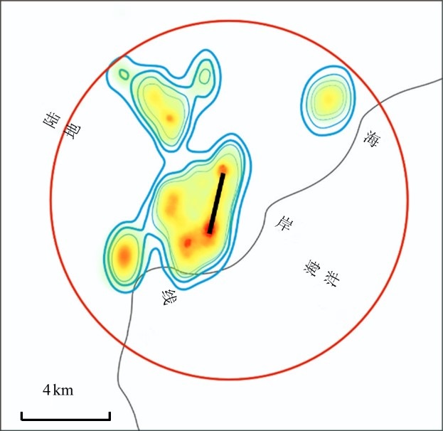
图1 机场及其周围鸟类分布情况示意图 红色圈表示8 km范围,圈内红色越深表示鸟类密度越高,绿色越深表示鸟类密度越低,蓝色为等密度线
Figure 1 Diagram of bird distribution at and around airports
| 目标层 | 准则层 | 指标层 | 指标单位 | 指标性质 | 含义 |
|---|---|---|---|---|---|
| 鸟击风险 因素 | 显性 因素 | 集群数量 | 只 | 负向 | 反映机场周围鸟类的生存数量 |
| 飞行速度 | km∙h −1 | 负向 | 反映机场周围鸟类飞行速度 | ||
| 飞行高度 | m | 负向 | 40 m以下鸟类平均飞行高度 | ||
| 正向 | 40 m以上鸟类平均飞行高度 | ||||
| 隐性 因素 | 网捕数量 | 只 | 负向 | 反映机场跑道周围鸟类的个体数量 | |
| 平均 体质量 | g | 负向 | 反映机场周围鸟类的重量数据 |
表1 鸟击风险评价指标体系
Table 1 Bird strike risk evaluation index system
| 目标层 | 准则层 | 指标层 | 指标单位 | 指标性质 | 含义 |
|---|---|---|---|---|---|
| 鸟击风险 因素 | 显性 因素 | 集群数量 | 只 | 负向 | 反映机场周围鸟类的生存数量 |
| 飞行速度 | km∙h −1 | 负向 | 反映机场周围鸟类飞行速度 | ||
| 飞行高度 | m | 负向 | 40 m以下鸟类平均飞行高度 | ||
| 正向 | 40 m以上鸟类平均飞行高度 | ||||
| 隐性 因素 | 网捕数量 | 只 | 负向 | 反映机场跑道周围鸟类的个体数量 | |
| 平均 体质量 | g | 负向 | 反映机场周围鸟类的重量数据 |
| 指标名称 | 指标单位 | V级影响严重 | IV级影响较大 | III级影响一般 | II级影响较小 | I级无显著影响 |
|---|---|---|---|---|---|---|
| 集群数量 | 只 | (122, 4347] | (25, 122] | (10, 25] | (5, 10] | ≤5 |
| 平均体质量 | g | (3600, 7150] | (1800, 3600] | (1000, 1800] | (200, 1000] | ≤200 |
| 网捕数量 | 只 | (37, 358] | (17, 37] | (8, 17] | (5, 8] | ≤5 |
| 飞行高度 | m | (32, 40] | (24, 32] | (16, 24] | (8, 16] | ≤8 |
| m | (40, 62] | (62, 84] | (84, 106] | (106, 128] | >128 | |
| 飞行速度 | km·h−1 | (90, 389] | (70, 90] | (50, 70] | (48, 50] | ≤48 |
表2 鸟击风险评价指标等级划分标准
Table 2 Standards for classification of bird strike risk evaluation indicators' levels
| 指标名称 | 指标单位 | V级影响严重 | IV级影响较大 | III级影响一般 | II级影响较小 | I级无显著影响 |
|---|---|---|---|---|---|---|
| 集群数量 | 只 | (122, 4347] | (25, 122] | (10, 25] | (5, 10] | ≤5 |
| 平均体质量 | g | (3600, 7150] | (1800, 3600] | (1000, 1800] | (200, 1000] | ≤200 |
| 网捕数量 | 只 | (37, 358] | (17, 37] | (8, 17] | (5, 8] | ≤5 |
| 飞行高度 | m | (32, 40] | (24, 32] | (16, 24] | (8, 16] | ≤8 |
| m | (40, 62] | (62, 84] | (84, 106] | (106, 128] | >128 | |
| 飞行速度 | km·h−1 | (90, 389] | (70, 90] | (50, 70] | (48, 50] | ≤48 |
| 指标名称 | V级影响严重 | IV级影响较大 | III级影响一般 | II级影响较小 | I级无显著影响 |
|---|---|---|---|---|---|
| 集群数量 | C− (4347, 1408.3, 0.1) | C− (122, 32.3, 0.1) | C−(25, 5, 0.1) | C− (10, 1.7, 0.1) | C− (5, 1.7, 0.1) |
| 平均体质量 | C−(7150, 1183.3, 0.1) | C− (3600, 600, 0.1) | C−(1800, 266.7, 0.1) | C− (1000, 266.7, 0.1) | C− (200, 66.7, 0.1) |
| 网捕数量 | C− (358, 107, 0.1) | C−(37, 6.7, 0.1) | C− (17, 3, 0.1) | C− (8, 1, 0.1) | C− (6.8, 3.2, 0.1) |
| 飞行高度 | C− (40, 2.7, 0.1) | C−(32, 2.7, 0.1) | C− (24, 2.7, 0.1) | C− (16, 2.7, 0.1) | C− (8, 2.7, 0.1) |
| C+(40, 7.3, 0.1) | C+(62, 7.3, 0.1) | C+(84, 7.3, 0.1) | C+(106, 7.3, 0.1) | C+(128, 7.3, 0.1) | |
| 飞行速度 | C− (389, 99.7, 0.1) | C− (108.5, 12.8, 0.1) | C− (88.5, 12.8, 0.1) | C− (51.9, 1.3, 0.1) | C−(92.4, 30.8, 0.1) |
表3 鸟击风险评价指标等级云模型
Table 3 Cloud model for classification of bird strike risk evaluation indicators' levels
| 指标名称 | V级影响严重 | IV级影响较大 | III级影响一般 | II级影响较小 | I级无显著影响 |
|---|---|---|---|---|---|
| 集群数量 | C− (4347, 1408.3, 0.1) | C− (122, 32.3, 0.1) | C−(25, 5, 0.1) | C− (10, 1.7, 0.1) | C− (5, 1.7, 0.1) |
| 平均体质量 | C−(7150, 1183.3, 0.1) | C− (3600, 600, 0.1) | C−(1800, 266.7, 0.1) | C− (1000, 266.7, 0.1) | C− (200, 66.7, 0.1) |
| 网捕数量 | C− (358, 107, 0.1) | C−(37, 6.7, 0.1) | C− (17, 3, 0.1) | C− (8, 1, 0.1) | C− (6.8, 3.2, 0.1) |
| 飞行高度 | C− (40, 2.7, 0.1) | C−(32, 2.7, 0.1) | C− (24, 2.7, 0.1) | C− (16, 2.7, 0.1) | C− (8, 2.7, 0.1) |
| C+(40, 7.3, 0.1) | C+(62, 7.3, 0.1) | C+(84, 7.3, 0.1) | C+(106, 7.3, 0.1) | C+(128, 7.3, 0.1) | |
| 飞行速度 | C− (389, 99.7, 0.1) | C− (108.5, 12.8, 0.1) | C− (88.5, 12.8, 0.1) | C− (51.9, 1.3, 0.1) | C−(92.4, 30.8, 0.1) |
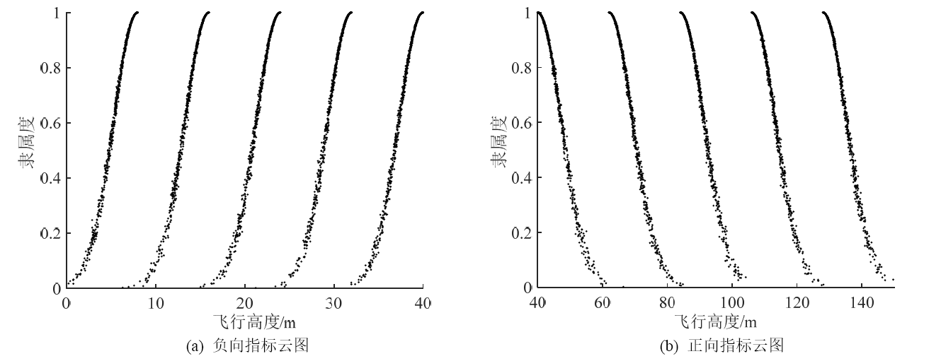
图2 飞行高度指标正负向云图
Figure 2 Flight altitude indicator positive and negative cloud map
| 序号 | 目 | 科 | 物种名 | 拉丁名 | 改进CRITIC- 云模型法 | 传统CRITIC- 云模型法 | 传统CRITIC- 云模型L法 |
|---|---|---|---|---|---|---|---|
| 1 | 鸻形目 | 鸥科 | 银鸥 | Larus argentatus | V | V | V |
| 2 | 鸻形目 | 鸥科 | 红嘴鸥 | Larus ridibundus | V | V | V |
| 3 | 雀形目 | 鹡鸰科 | 理氏鹨 | Anthus richardi | V | V | I |
| 4 | 雀形目 | 百灵科 | 云雀 | Alauda arvensis | V | V | V |
| 5 | 雀形目 | 燕科 | 家燕 | Hirundo rustica | V | I | V |
| 6 | 隼形目 | 隼科 | 游隼 | Falco peregrinus | V | V | II |
| 7 | 雁形目 | 鸭科 | 翘鼻麻鸭 | Tadorna tadorna | V | V | V |
| 8 | 雁形目 | 鸭科 | 小天鹅 | Cygnus columbianus | V | V | III |
| 9 | 鸡形目 | 雉科 | 雉鸡 | Phasianus colchicus | IV | IV | III |
| 10 | 鸻形目 | 丘鹬科 | 黑腹滨鹬 | Calidris alpina | IV | IV | I |
| 11 | 鸻形目 | 丘鹬科 | 中杓鹬 | Numenius phaeopus | IV | IV | IV |
| 12 | 雁形目 | 鸭科 | 斑脸海番鸭 | Melanitta fusca | IV | IV | III |
| 13 | 鸻形目 | 鸥科 | 黑嘴鸥 | Larus saundersi | IV | IV | I |
| 14 | 鸻形目 | 丘鹬科 | 白腰草鹬 | Tringa ochropus | IV | IV | I |
| 15 | 鸻形目 | 鸥科 | 黑尾鸥 | Larus crassirostris | IV | IV | I |
| 16 | 鸻形目 | 丘鹬科 | 矶鹬 | Actitis actitis hypoleucos | IV | IV | I |
| 17 | 雀形目 | 伯劳科 | 红尾伯劳 | Lanius cristatus | IV | IV | I |
| 18 | 鸻形目 | 丘鹬科 | 青脚鹬 | Tringa nebularia | IV | IV | I |
| 19 | 鸻形目 | 鸻科 | 环颈鸻 | Charadrius alexandrinus | IV | IV | I |
| 20 | 雀形目 | 鸦科 | 喜鹊 | Pica pica | IV | IV | III |
| 21 | 雀形目 | 雀科 | 麻雀 | Passer montanus | IV | IV | I |
| 22 | 鲣鸟目 | 鸬鹚科 | 普通鸬鹚 | Phalacrocorax carbo | IV | IV | II |
| 23 | 雀形目 | 鸦科 | 秃鼻乌鸦 | Corvus frugilegus | IV | IV | III |
| 24 | 鸻形目 | 丘鹬科 | 大杓鹬 | Numenius madagascariensis | IV | II | II |
| 25 | 雁形目 | 鸭科 | 斑嘴鸭 | Anas poecilorhyncha | IV | V | V |
| 26 | 雁形目 | 鸭科 | 白额雁 | Anser albifrons | IV | IV | IV |
| 27 | 鸽形目 | 鸠鸽科 | 家鸽 | Columba livia domestica | III | I | V |
| 28 | 鸻形目 | 丘鹬科 | 白腰杓鹬 | Numenius arquata | II | IV | II |
| 29 | 鸻形目 | 鸥科 | 棕头鸥 | Larus brunnicephalus | II | II | IV |
| 30 | 雀形目 | 鹎科 | 白头鹎 | Pycnonotus sinensis | II | IV | I |
| 31 | 鸻形目 | 蛎鹬科 | 蛎鹬 | Haematopus ostralegus | I | I | IV |
| 32 | 鸻形目 | 鸻科 | 金眶鸻 | Pluvialis fulva | I | IV | I |
| 33 | 鸻形目 | 丘鹬科 | 尖尾滨鹬 | Calidris acuminata | I | IV | I |
| 34 | 鸽形目 | 鸠鸽科 | 普通燕鸥 | Sterna hirundo | I | IV | I |
| 35 | 鸻形目 | 反嘴鹬科 | 黑翅长脚鹬 | Himantopus himantopus | I | I | IV |
| 36 | 鸻形目 | 丘鹬科 | 翘嘴鹬 | Xenus cinereus | I | IV | I |
| 37 | 鸮形目 | 鸱鸮科 | 纵纹腹小鸮 | Athene noctua | I | III | IV |
| 38 | 雀形目 | 百灵科 | 凤头百灵 | Galerida cristata | I | IV | IV |
| 39 | 隼形目 | 隼科 | 燕隼 | Falco subbuteo | I | IV | V |
表4 机场鸟类风险评价结果
Table 4 Results of airport bird strike risk assessment
| 序号 | 目 | 科 | 物种名 | 拉丁名 | 改进CRITIC- 云模型法 | 传统CRITIC- 云模型法 | 传统CRITIC- 云模型L法 |
|---|---|---|---|---|---|---|---|
| 1 | 鸻形目 | 鸥科 | 银鸥 | Larus argentatus | V | V | V |
| 2 | 鸻形目 | 鸥科 | 红嘴鸥 | Larus ridibundus | V | V | V |
| 3 | 雀形目 | 鹡鸰科 | 理氏鹨 | Anthus richardi | V | V | I |
| 4 | 雀形目 | 百灵科 | 云雀 | Alauda arvensis | V | V | V |
| 5 | 雀形目 | 燕科 | 家燕 | Hirundo rustica | V | I | V |
| 6 | 隼形目 | 隼科 | 游隼 | Falco peregrinus | V | V | II |
| 7 | 雁形目 | 鸭科 | 翘鼻麻鸭 | Tadorna tadorna | V | V | V |
| 8 | 雁形目 | 鸭科 | 小天鹅 | Cygnus columbianus | V | V | III |
| 9 | 鸡形目 | 雉科 | 雉鸡 | Phasianus colchicus | IV | IV | III |
| 10 | 鸻形目 | 丘鹬科 | 黑腹滨鹬 | Calidris alpina | IV | IV | I |
| 11 | 鸻形目 | 丘鹬科 | 中杓鹬 | Numenius phaeopus | IV | IV | IV |
| 12 | 雁形目 | 鸭科 | 斑脸海番鸭 | Melanitta fusca | IV | IV | III |
| 13 | 鸻形目 | 鸥科 | 黑嘴鸥 | Larus saundersi | IV | IV | I |
| 14 | 鸻形目 | 丘鹬科 | 白腰草鹬 | Tringa ochropus | IV | IV | I |
| 15 | 鸻形目 | 鸥科 | 黑尾鸥 | Larus crassirostris | IV | IV | I |
| 16 | 鸻形目 | 丘鹬科 | 矶鹬 | Actitis actitis hypoleucos | IV | IV | I |
| 17 | 雀形目 | 伯劳科 | 红尾伯劳 | Lanius cristatus | IV | IV | I |
| 18 | 鸻形目 | 丘鹬科 | 青脚鹬 | Tringa nebularia | IV | IV | I |
| 19 | 鸻形目 | 鸻科 | 环颈鸻 | Charadrius alexandrinus | IV | IV | I |
| 20 | 雀形目 | 鸦科 | 喜鹊 | Pica pica | IV | IV | III |
| 21 | 雀形目 | 雀科 | 麻雀 | Passer montanus | IV | IV | I |
| 22 | 鲣鸟目 | 鸬鹚科 | 普通鸬鹚 | Phalacrocorax carbo | IV | IV | II |
| 23 | 雀形目 | 鸦科 | 秃鼻乌鸦 | Corvus frugilegus | IV | IV | III |
| 24 | 鸻形目 | 丘鹬科 | 大杓鹬 | Numenius madagascariensis | IV | II | II |
| 25 | 雁形目 | 鸭科 | 斑嘴鸭 | Anas poecilorhyncha | IV | V | V |
| 26 | 雁形目 | 鸭科 | 白额雁 | Anser albifrons | IV | IV | IV |
| 27 | 鸽形目 | 鸠鸽科 | 家鸽 | Columba livia domestica | III | I | V |
| 28 | 鸻形目 | 丘鹬科 | 白腰杓鹬 | Numenius arquata | II | IV | II |
| 29 | 鸻形目 | 鸥科 | 棕头鸥 | Larus brunnicephalus | II | II | IV |
| 30 | 雀形目 | 鹎科 | 白头鹎 | Pycnonotus sinensis | II | IV | I |
| 31 | 鸻形目 | 蛎鹬科 | 蛎鹬 | Haematopus ostralegus | I | I | IV |
| 32 | 鸻形目 | 鸻科 | 金眶鸻 | Pluvialis fulva | I | IV | I |
| 33 | 鸻形目 | 丘鹬科 | 尖尾滨鹬 | Calidris acuminata | I | IV | I |
| 34 | 鸽形目 | 鸠鸽科 | 普通燕鸥 | Sterna hirundo | I | IV | I |
| 35 | 鸻形目 | 反嘴鹬科 | 黑翅长脚鹬 | Himantopus himantopus | I | I | IV |
| 36 | 鸻形目 | 丘鹬科 | 翘嘴鹬 | Xenus cinereus | I | IV | I |
| 37 | 鸮形目 | 鸱鸮科 | 纵纹腹小鸮 | Athene noctua | I | III | IV |
| 38 | 雀形目 | 百灵科 | 凤头百灵 | Galerida cristata | I | IV | IV |
| 39 | 隼形目 | 隼科 | 燕隼 | Falco subbuteo | I | IV | V |
| 风险等级 | 种数/种 | 种类 |
|---|---|---|
| V | 8 | 红嘴鸥、银鸥、云雀、理氏鹨、家燕、游隼、翘鼻麻鸭、小天鹅 |
| IV | 18 | 雉鸡、斑脸海番鸭、中杓鹬、大杓鹬、黑腹滨鹬、黑嘴鸥、环颈鸻、青脚鹬、白腰草鹬、矶鹬、红尾伯劳、喜鹊、黑尾鸥、麻雀、普通鸬鹚、秃鼻乌鸦、斑嘴鸭、白额雁 |
| III | 13 | 鹌鹑 (Coturnix coturnix)、凤头鸊鷉 (Podiceps cristatus)、斑尾塍鹬 (Limosa lapponica)、针尾沙锥 (Gallinago stenura)、灰尾漂鹬 (Tringa brevipes)、红胁蓝尾鸲 (Zosterops erythropleurus)、戴胜 (Upupa epops)、家鸽、苍鹭 (Ardea cinerea)、中杜鹃 (Cuculus saturatus)、白鹭 (Egretta garzetta)、凤头蜂鹰 (Pernis ptilorhynchus)、绿头鸭 (Anas platyrhynchos) |
| II | 19 | 灰斑鸻 (Plurialis fulva)、白腰杓鹬、棕头鸥、草鹭 (Ardea purpurea)、大白鹭 (Ardea alba)、白头鹎、白鹡鸰 (Motacilla alba)、燕雀 (Fringilla montifringilla)、黑枕黄鹂 (Oriolus chinensis)、紫背苇鳽 (Ixobrychus eurhythmus)、红隼 (Falco tinnunculus)、红脚隼 (Falco vespertinus)、黑水鸡 (Gallinula chloropus)、金翅雀 (Carduelis sinica)、池鹭 (Ardeola bacchus)、赤麻鸭 (Tadorna ferruginea)、日本松雀鹰 (Accipiter gularis)、普通鵟 (Buteo buteo)、赤膀鸭 (Anas strepera) |
| I | 82 | 小鷿鷈 (Tachybaptus ruficollis)、白尾鹞 (Circus cyaneus)、金眶鸻、蛎鹬、金斑鸻 (Plurialis fulva)、小杓鹬 (Numenius minutus)、尖尾滨鹬、普通燕鸥、黄苇鳽 (Ixobrychus sinensis)、丘鹬 (Scolopax rusticola)、扇尾沙锥 (Gallinago gallinago)、黑尾塍鹬 (Limosa limosa)、鹤鹬 (Tringa erythropus)、红脚鹬 (Tringa totanus)、林鹬 (Tringa glareola)、翘嘴鹬、白腰雨燕 (Apus pacificus)、普通夜鹰 (Caprimulgus indicus)、普通翠鸟 (Alcedo atthis)、红角鸮 (Otus scops)、纵纹腹小鸮、楔尾伯劳 (Lanius sphenocercus)、黑卷尾 (Dicrurus macrocercus)、达乌里寒鸦 (Corvus dauuricus)、中华攀雀 (Remiz consobrinus)、蒙古百灵 (Melanocorypha mongolica)、凤头百灵、黄眉柳莺 (Phylloscopus inornatus)、冕柳莺 (Phylloscopus coronatus)、褐柳莺 (Phylloscopus fuscatus)、双斑绿柳莺 (Phylloscopus plumbeitarsus)、黑眉苇莺 (Acrocephalus bistrigiceps)、厚嘴苇莺 (Arundinax aedon)、东方大苇莺 (Acrocephalus orientalis)、灰惊鸟 (Spodiopsar cineraceus)、灰背鸫 (Turdus hortulorum)、虎斑地鸫 (Zoothera dauma)、乌鸫 (Turdus merula)、北红尾鸲 (Phoenicurus auroreus)、乌鹟 (Muscicapa sibirica)、北灰鹟 (Muscicapa latirostris)、红喉姬鹟 (Ficedula parva)、布氏鹨 (Anthus godlewskii)、树鹨 (Anthus hodgsoni)、红喉鹨 (Anthus cervinus)、白眉鹀 (Emberiza tristrami)、黄眉鹀 (Emberiza chrysophrys)、灰头鹀 (Emberiza spodocephala)、苇鹀 (Emberiza pallasi)、三道眉草鹀 (Emberiza cioides)、铁爪鹀 (Calcarius lapponicus)、黑翅长脚鹬、大斑啄木鸟 (Dendrocopos major)、普通秧鸡 (Rallus indicus)、反嘴鹬 (Recurvirostra avosetta)、灰头麦鸡 (Vanellus cinereus)、泽鹬 (Tringa stagnatilis)、山斑鸠 (Streptopelia orientalis Latham)、灰斑鸠 (Streptopelia decaocto)、小蝗莺 (Helopsaltes certhiola)、红胁绣眼鸟 (Zosterops erythropleurus)、白眉鸫 (Turdus obscurus)、红尾鸫 (Oenanthe chrysopygia)、斑鸫 (Turdus naumanni)、蓝喉歌鸲 (Luscinia svecica)、红喉歌鸲 (Luscinia calliope)、红尾歌鸲 (Luscinia sibilans)、黄鹡鸰 (Motacilla flava)、短耳鸮 (Asio flammeus)、珠颈斑鸠 (Streptopelia chinensis)、金腰燕 (Cecropis daurica)、黄腰柳莺 (Phylloscopus proregulus)、棕扇尾莺 (Cisticola juncidis)、棕头鸦雀 (Paradoxornis webbianus)、芦鹀 (Emberiza schoeniclus)、黑喉石䳭 (Saxicola torquata)、灰头绿啄木鸟 (Picus canus)、四声杜鹃 (Cuculus micropterus)、燕隼、绿翅鸭 (Anas crecca)、雀鹰 (Accipiter nisus)、鹊鹞 (Circus melanoleucos) |
表5 改进CRITIC-云模型法评价结果
Table 5 Improve the evaluation results using the CRITIC-Cloud Model method
| 风险等级 | 种数/种 | 种类 |
|---|---|---|
| V | 8 | 红嘴鸥、银鸥、云雀、理氏鹨、家燕、游隼、翘鼻麻鸭、小天鹅 |
| IV | 18 | 雉鸡、斑脸海番鸭、中杓鹬、大杓鹬、黑腹滨鹬、黑嘴鸥、环颈鸻、青脚鹬、白腰草鹬、矶鹬、红尾伯劳、喜鹊、黑尾鸥、麻雀、普通鸬鹚、秃鼻乌鸦、斑嘴鸭、白额雁 |
| III | 13 | 鹌鹑 (Coturnix coturnix)、凤头鸊鷉 (Podiceps cristatus)、斑尾塍鹬 (Limosa lapponica)、针尾沙锥 (Gallinago stenura)、灰尾漂鹬 (Tringa brevipes)、红胁蓝尾鸲 (Zosterops erythropleurus)、戴胜 (Upupa epops)、家鸽、苍鹭 (Ardea cinerea)、中杜鹃 (Cuculus saturatus)、白鹭 (Egretta garzetta)、凤头蜂鹰 (Pernis ptilorhynchus)、绿头鸭 (Anas platyrhynchos) |
| II | 19 | 灰斑鸻 (Plurialis fulva)、白腰杓鹬、棕头鸥、草鹭 (Ardea purpurea)、大白鹭 (Ardea alba)、白头鹎、白鹡鸰 (Motacilla alba)、燕雀 (Fringilla montifringilla)、黑枕黄鹂 (Oriolus chinensis)、紫背苇鳽 (Ixobrychus eurhythmus)、红隼 (Falco tinnunculus)、红脚隼 (Falco vespertinus)、黑水鸡 (Gallinula chloropus)、金翅雀 (Carduelis sinica)、池鹭 (Ardeola bacchus)、赤麻鸭 (Tadorna ferruginea)、日本松雀鹰 (Accipiter gularis)、普通鵟 (Buteo buteo)、赤膀鸭 (Anas strepera) |
| I | 82 | 小鷿鷈 (Tachybaptus ruficollis)、白尾鹞 (Circus cyaneus)、金眶鸻、蛎鹬、金斑鸻 (Plurialis fulva)、小杓鹬 (Numenius minutus)、尖尾滨鹬、普通燕鸥、黄苇鳽 (Ixobrychus sinensis)、丘鹬 (Scolopax rusticola)、扇尾沙锥 (Gallinago gallinago)、黑尾塍鹬 (Limosa limosa)、鹤鹬 (Tringa erythropus)、红脚鹬 (Tringa totanus)、林鹬 (Tringa glareola)、翘嘴鹬、白腰雨燕 (Apus pacificus)、普通夜鹰 (Caprimulgus indicus)、普通翠鸟 (Alcedo atthis)、红角鸮 (Otus scops)、纵纹腹小鸮、楔尾伯劳 (Lanius sphenocercus)、黑卷尾 (Dicrurus macrocercus)、达乌里寒鸦 (Corvus dauuricus)、中华攀雀 (Remiz consobrinus)、蒙古百灵 (Melanocorypha mongolica)、凤头百灵、黄眉柳莺 (Phylloscopus inornatus)、冕柳莺 (Phylloscopus coronatus)、褐柳莺 (Phylloscopus fuscatus)、双斑绿柳莺 (Phylloscopus plumbeitarsus)、黑眉苇莺 (Acrocephalus bistrigiceps)、厚嘴苇莺 (Arundinax aedon)、东方大苇莺 (Acrocephalus orientalis)、灰惊鸟 (Spodiopsar cineraceus)、灰背鸫 (Turdus hortulorum)、虎斑地鸫 (Zoothera dauma)、乌鸫 (Turdus merula)、北红尾鸲 (Phoenicurus auroreus)、乌鹟 (Muscicapa sibirica)、北灰鹟 (Muscicapa latirostris)、红喉姬鹟 (Ficedula parva)、布氏鹨 (Anthus godlewskii)、树鹨 (Anthus hodgsoni)、红喉鹨 (Anthus cervinus)、白眉鹀 (Emberiza tristrami)、黄眉鹀 (Emberiza chrysophrys)、灰头鹀 (Emberiza spodocephala)、苇鹀 (Emberiza pallasi)、三道眉草鹀 (Emberiza cioides)、铁爪鹀 (Calcarius lapponicus)、黑翅长脚鹬、大斑啄木鸟 (Dendrocopos major)、普通秧鸡 (Rallus indicus)、反嘴鹬 (Recurvirostra avosetta)、灰头麦鸡 (Vanellus cinereus)、泽鹬 (Tringa stagnatilis)、山斑鸠 (Streptopelia orientalis Latham)、灰斑鸠 (Streptopelia decaocto)、小蝗莺 (Helopsaltes certhiola)、红胁绣眼鸟 (Zosterops erythropleurus)、白眉鸫 (Turdus obscurus)、红尾鸫 (Oenanthe chrysopygia)、斑鸫 (Turdus naumanni)、蓝喉歌鸲 (Luscinia svecica)、红喉歌鸲 (Luscinia calliope)、红尾歌鸲 (Luscinia sibilans)、黄鹡鸰 (Motacilla flava)、短耳鸮 (Asio flammeus)、珠颈斑鸠 (Streptopelia chinensis)、金腰燕 (Cecropis daurica)、黄腰柳莺 (Phylloscopus proregulus)、棕扇尾莺 (Cisticola juncidis)、棕头鸦雀 (Paradoxornis webbianus)、芦鹀 (Emberiza schoeniclus)、黑喉石䳭 (Saxicola torquata)、灰头绿啄木鸟 (Picus canus)、四声杜鹃 (Cuculus micropterus)、燕隼、绿翅鸭 (Anas crecca)、雀鹰 (Accipiter nisus)、鹊鹞 (Circus melanoleucos) |
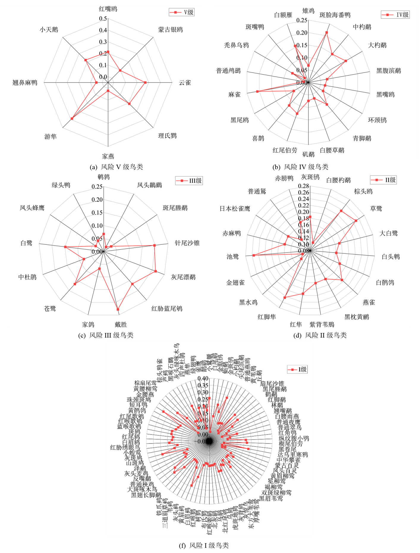
图3 机场高危鸟种评价等级图
Figure 3 Evaluation level chart of high-risk bird species at airport
| [1] | DIAKOULAKI D, MAVROTAS G, PAPAYANNAKIS L, 1995. Determining objective weights in multiple criteria problems: the critic method[J]. Computers & Operations Research, 22(7):763-770. |
| [2] |
ALLAN J, 2006. A heuristic risk assessment technique for birdstrike management at airports[J]. Risk Analysis, 26(3):723-729.
PMID |
| [3] | BLACKWELL B F, SCHAFER L M, HELON D A, et al., 2008. Bird use of stormwater-management ponds: Decreasing avian attractants on airports[J]. Landscape and Urban Planning, 86(2):162-170. |
| [4] | BOTH I, GASTERN H, DEKKER A, 2010. A quantified species specific Bird Hazard Index[M]. Carirns: International Bird Strike Committee. |
| [5] | SOLDATINI S, ALBORES-BARAJAS Y V, LOVATO T, et al., 2011. Wildlife strike risk assessment in several Italian airports: Lessons from BRI and a New Methodology Implementation[J]. PloS One, 6(12):6. |
| [6] | WASHBURN B E, BEGIER M J, WRIGHT S E, 2015. Collisions between eagles and aircraft: An increasing problem in the airport environment[J]. Journal of Raptor Research, 49(2):192-200. |
| [7] | DEVAULT T L, BLACKWELL B F, SEAMANS T W, et al., 2016. Identification of off airport interspecific avian hazards to aircraft[J]. The Journal of Wildlife Management, 80(4):746-752. |
| [8] | HU X Y, XING P, YANG F, et al., 2020. A birdstrike risk assessment model and its application at Ordos Airport[R]. China. Scientific Reports, 10:19627. |
| [9] | WU H W, ZHEN J, ZHANG J, 2020. Urban rail transit operation safety evaluation based on an improved critic method and cloud model[J]. Journal of Rail Transport Planning & Management, 16:1-13. |
| [10] | 曹志成, 2024. 基于CRITIC和云模型的航天标准化师评价方法研究[J]. 载人航天, 30(1):104-111. |
| CAO Z C, 2024. Research on evaluation method of space standardization engineers based on CRITIC and cloud model[J]. Manned Spaceflight, 30(1):104-111. | |
| [11] | 陈贵林, 2010. 一种定性定量信息转换的不确定性模型-云模型[J]. 计算机应用研究, 27(6):2006-2010. |
| CHEN G L, 2010. Uncertain model of qualitative/qualitative information transformation-cloud model[J]. Application Research of Computers, 27(6):2006-2010. | |
| [12] | 陈唯实, 万健, 李敬, 2013. 基于机场探鸟雷达数据的鸟击风险评价[J]. 北京航空航天大学学报, 39(11):1431-1436. |
| CHEN W S, WAN J, LI J, 2013. Bird strike risk assessment with airport avian radar data[J]. Journal of Beijing University of Aeronautics and Astronautics, 39(11):1431-1436. | |
| [13] | 高强, 彭秀华. 2023. 基于云模型-熵权法的大坝风险等级评价[J]. 人民长江, 54(11):208-213. |
| GAO Q, PENG X H, 2023. Dam risk level evaluation based on cloud model-entropy weight method[J]. Yangtze River, 54(11):208-213. | |
| [14] | 李德毅, 杜鹢, 2005. 不确定性人工智能[M]. 北京: 国防工业出版社:143-166. |
| LI D Y, DU Y, 2005. Artificial intelligence with uncertainty[M]. Beijing: National Defense Industry Press:143-166. | |
| [15] | 李德毅, 孟海军, 史雪梅, 1995. 隶属云和隶属云发生器[J]. 计算机研究与发展, 32(6):15-20. |
| LI D Y, MENG H J, SHI X M, 1995. Membership clouds and membership cloud generators[J]. Computer R & D, 32(6):15-20. | |
| [16] | 李德毅, 刘常昱, 2004. 论正态云模型的普适性[J]. 中国工程科学, 6(8):28-33. |
| LI D Y, LIU C Y, 2004. Study on the universality of the normal cloud model[J]. Engineering Science, 6(8):28-33. | |
| [17] | 李万德, 洪磊, 王官胜, 等, 2020. 云南宁蒗泸沽湖机场鸟类多样性及鸟击风险评价[J]. 西南林业大学学报(自然科学), 40(2):96-102. |
| LI W D, HONG L, WANG G S, et al., 2020. Avain diversity and bird strike risk evaluation in Ninglang Luguhu airport, Yunnan[J]. Journal of Southwest Forestry University (Natural Science), 40(2):96-102. | |
| [18] | 李振强, 曹琦, 孟庆军, 2023. 基于指数标度AHP-黄金分割率法云模型的军事设施建设项目风险评价[J]. 军事运筹与评价, 38(145):23-29. |
| LI Z Q, CAO Q, MENG Q J, 2023. Risk assessment of military facility construction projects based on the AHP with exponential scaling, golden section method, and cloud model[J]. Military Operations Research and Assessment, 38(145):23-29. | |
| [19] | 梁淑敏, 王维, 高利平, 等, 2016. 鸟类飞行高度与民航机场鸟击防范的关系[J]. 安全与环境学报, 16(1):104-109. |
| LIANG S M, WANG W, GAO L P, et al., 2016. Analysis of the relationship between the birds flying height and guard against the bird striking in the civil aviation airport[J]. Journal of Safety and Environment, 16(1):104-109. | |
| [20] | 梁佩云, 2020. 基于改进的CRITIC-VTKOR法的科技服务业服务创新能力评价研究[D]. 安徽: 合肥工业大学:25-26. |
| LIANG P Y, 2020. Research on evaluation of service innovation capability of science and technology service industry based on the improved CRITIC-VIKOR method[D]. Anhui: Hefei University of Technology:25-26. | |
| [21] | 柳毅, 徐焕然, 袁红, 等, 2017. 天津滨海国际机场鸟类群落结构及多样性特[J]. 生态学杂志, 36(3):740-746. |
| LIU Y, XU H R, YUAN H, et al., 2017. Bird community structure and diversity at Tianjin Binhai international airport[J]. Chinese Journal of Ecology, 36(3):740-746. | |
| [22] | 吕志鹏, 吴鸣, 宋振浩, 等, 2020. 电能质量 CRITIC-TOPSIS综合评价方法[J]. 电机与控制学报, 24(1):137-144. |
| LÜ Z P, WU N, SONG Z H, et al., 2020. Comprehensive evaluation of power quality on CRITIC-TOPSIS method[J]. Electric Machines and Control, 24(1):137-144. | |
| [23] | 石子凡, 周岩, 邵荃, 2021. 基于机场生态环境与飞行程序的鸟击风险评价[J]. 科技通报, 37(8):120-126. |
| SHI Z F, ZHOU Y, SHAO Q, 2021. Risk assessment of bird strike based on airport environment and flight procedures[J]. Bulletin of Science and Technology, 37(8):120-126. | |
| [24] | 谭豪, 脱云飞, 王倩, 等, 2023. 基于CRITIC-VTKOR法的云南省水资源承载力综合评价[J]. 水资源与水工程学报, 33(4):118-126. |
| TAN H, TUO Y F, WANG Q, et al., 2023. Comprehensive evaluation of water carrying capacity of Yunnan Province based on CRITIC-VIKOR method[J]. Journal of Water Resources & Water Engineering, 33(4):118-126. | |
| [25] | 王志高, 周放, 张勇, 等, 2008. 南宁吴圩国际机场春季鸟类鸟撞风险分析[J]. 四川动物, 27(4):585-589. |
| WANG Z G, ZHOU F, ZHANG Y, et al., 2008. Bird strike risk analysis in spring at Nanning Wuxu international airport[J]. Sichuan Journal of Zoology, 27(4):585-589. | |
| [26] | 吴雪, 杜杰, 李晓娟, 等, 2015. 重庆江北机场鸟类群落结构及鸟击防范[J]. 生态学杂志, 34(7):2015-2024. |
| WU X, DU J, LI X J, et al., 2015. Avian community structure and bird strike prevention measures at Jiangbei airport in Chongqing city[J]. Chinese Journal of Ecology, 34(7):2015-2024. | |
| [27] | 谢皓宇, 牛松山, 郑万山, 等, 2023. 基于CRITIC-熵权法的桥梁地震风险多尺度评价[J]. 重庆交通大学学报(自然科学版), 42(7):15-20. |
| XIE H Y, NIU S S, ZHENG W S, et al., 2023. Multi-scale assessment of bridge's seismic hazard basedon critic-entropy weighting method[J]. Journal of Chongqing Jiaotong University (Natural Science), 42(7):15-20. | |
| [28] | 郑光美, 1995. 鸟类学[M]. 北京: 北京师范大学出版社:51-52. |
| ZHENG G M, 1995. Ornithology[M]. Beijing: Beijing Normal University Press: 51-52 | |
| [29] | 中国民用航空局机场司, 2016. 2015年度中国民航鸟击航空器信息分析报告[R]. 北京: CAA, CAST机场研究所. |
| CAAC, 2016. Analysis report on bird strike incidents on aircraft in China's civil aviation in 2015[R]. Beijing: CAA, CAST Airport Research Institute. | |
| [30] | 中国民用航空局机场司, 2022. 运输机场鸟击航空器防范危险鸟种目录[R]. 北京: 民航局机场司. |
| CAAC, 2022. Directory of hazardous bird species for bird strike prevention at transport airports[R]. Beijing: CAAC. | |
| [31] | 邹小华, 徐平, 2018. 基于风险耦合的洞室群施工安全风险云评价[J]. 水利技术监督, 37(2):112-115. |
| ZOU X H, XU P, 2018. Cloud evaluation of construction safety risks for tunnel groups based on risk coupling[J]. Hydraulic Technical Supervision, 37(2):112-115. |
| No related articles found! |
| 阅读次数 | ||||||
|
全文 |
|
|||||
|
摘要 |
|
|||||